Broadway from Spring Street, Newport, Rhode Island

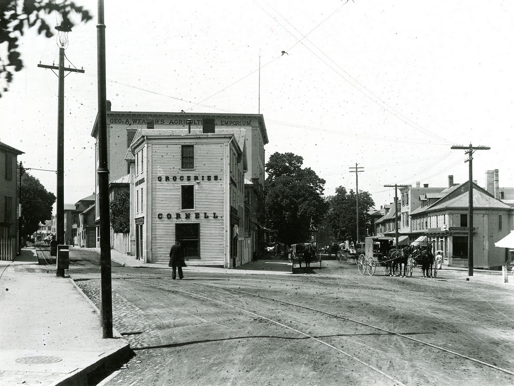
Looking south on Broadway toward the corner of Spring Street in Newport, around 1885. Image courtesy of the Providence Public Library.
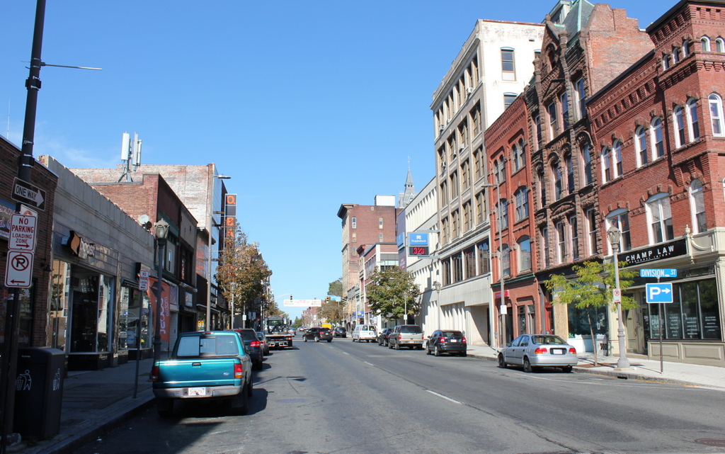
The scene in 2017:

These two photos were taken more than 130 years apart, yet they show remarkably little change. In fact, many of these buildings were already old by the time the first photo was taken. Newport had been a prosperous seaport throughout much of the 18th century, but its economy was hit hard by the American Revolution. Its shipping industry never fully recovered, and the city saw very little growth during the first half of the 19th century. The first federal census, taken in 1790, shows 6,719 residents living here, and over the next 50 years Newport saw only a very modest increase in population, with 8,333 by 1840.

This long period of stagnation hurt Newport’s economy, and there was very little new construction during this time. By the time the first photo was taken around 1885, Newport had reinvented itself as a Gilded Age summer resort, with most of this development occurring to the south of the downtown area. As a result, downtown Newport remained remarkably well-preserved, and it now boasts one of the largest collection of 18th and early 19th century buildings in the country, many of which are visible in this scene.

Along with the buildings themselves, Newport has also retained its colonial-era street network, complete with narrow streets, sharply-angled intersections, and oddly-shaped building lots. These photos show the view looking south on Broadway, at the complex intersection of Broadway, Spring Street, Bull Street, and Marlborough Street. Both Spring Street, to the left, and Marlborough Street, on the extreme right, intersect with Broadway at sharp angles, creating triangular-shaped lots on either side of Broadway.

The narrower of these two lots is on the left, between Broadway and Spring Street. Long before the Flatiron Building was constructed on a similarly-shaped plot of land, a small three-story, wood-frame commercial building was built here. It appears to date back to the late 18th or early 19th centuries, and by the time the first photo was taken it was occupied by Cornell & Son, a grocery store operated by William Cornell and his son Rodman. William also lived here in the building, and the 1880 census showed him here with his wife Sarah and their daughter Ellen.

Today, this scene has not undergone few significant changes, and many of the buildings from the first photo are still standing, including the former Cornell building. Newport remains a popular summer resort, and the storefronts in this scene are now filled with a variety of shops and restaurants that cater to tourists and seasonal residents. Because of its level of preservation, and its high concentration of historic buildings, the downtown area now forms the Newport Historic District, which was designated as a National Historic Landmark in 1968.

First Congregational Church, Holyoke, Mass

The First Congregational Church, at the corner of Hampden and Pleasant Streets in Holyoke, around 1910. Image from Holyoke: Past and Present Progress and Prosperity (1910).

The church in 2017:

Holyoke’s First Congregational Church was established in 1799, as the Third Congregational Church of West Springfield. At the time, West Springfield encompassed the present-day towns of Agawam and Holyoke. The latter was variously known as the Third Parish or Ireland Parish, and was only sparsely settled, with most of its population was located along Northampton Street. The church had only 11 members when it was established, and shared space with the First Baptist Church. Not until 1834 did the Congregational church move into a building of its own, upon the completion of a modest Greek Revival-style church near the corner of Northampton and Dwight Streets.

Holyoke was incorporated as a separate municipality in 1850, and the church became the First Congregational Church of Holyoke. Around the same time, the new town was undergoing a rapid transformation from a small farming community into a major industrial center. However, most of this new development was along the banks of the Connecticut River, far removed from the church on Northampton Street. Despite a significant growth in Holyoke’s population, the church actually declined in membership during this time, with many parishioners leaving to join the newly-established Second Congregational Church, with its more convenient location at the corner of High and Dwight Streets.

Faced with this decline, along with a revolving door of pastors throughout the 1870s and 1880s, the church finally decided to relocate closer to downtown Holyoke. In 1886, the church purchased this lot at the corner of Hampden and Pleasant Streets, and by the end of the following year it had completed a chapel on the site, which is visible on the far right side of both photos. Although still located some distance from downtown Holyoke, the new church was situated in the midst of a new upscale residential development, and within just a few years its membership had more than doubled, from 64 at the time of the 1887 move, to around 160 by 1890.

Church services were held in this chapel until 1894, when the church building itself was completed. The new church was the work of prominent Holyoke architect George P. B. Alderman, and featured a Romanesque-style design that was common for churches of this period. The exterior was primarily brick, with brownstone trim, and included common Romanesque elements such as rounded arches, asymmetrical facades, and a mix of towers and turrets of varying heights. The overall design bore some resemblance to the new Second Congregational Church, which had been completed almost a decade earlier on Maple Street, although that church had been constructed entirely of brownstone instead of brick.

Throughout the 20th century, the First Congregational Church underwent a series of mergers and name changes. In 1961, it became First United Congregational Church after a merger with the German Reformed Church, and then in 1973 it became Grace United Church after merging with Grace Church. The members of Grace United continued to worship here until 1995, when the church merged with the Second Congregational Church, becoming the United Congregational Church of Holyoke. Following this merger, most religious services were held at the former Second Congregational building on Maple Street, but the church retained ownership of the former First Congregational building here on Pleasant Street, which was repurposed as the E. B. Robinson Ecumenical Mission Center. The church still owns the property today, and the historic building is still standing with few exterior changes since the first photo was taken, although it appears to vacant as of the 2017 photo.

Second Congregational Church, Holyoke, Mass

The Second Congregational Church, seen from Maple Street near the corner of Appleton Street in Holyoke, around 1891. Image from Holyoke Illustrated (1891).

The church in 2017:

The Second Congregational Church was established in 1849, at a time when Holyoke was just beginning its transformation into a major industrial center. Prior to this time, the area’s population was centered further up the hill from here, along Northampton Street. The First Congregational Church was located there, but this site proved inconvenient for those who were moving into the newly-developed area along the river. This led to the formation of the Second Congregational Church, which built its first meeting house at the corner of High and Dwight Streets in 1853.

At the time, the church had just 36 members, in a building that could seat 800. However, as Holyoke grew so did the congregation, and by the 1880s it had outgrown the old building. Its location, right at the intersection of two major streets, had also become undesirable because of the levels of noise outside, so in 1885 the church moved into this new building a few blocks away, at the corner of Maple and Appleton Streets. Like many churches of the era, it was built of brownstone and featured Romanesque-style architecture, including an asymmetrical main facade with a tall tower at one corner and a shorter one at the other. The book Story of the Holyoke Churches, published a few years later in 1890, provides the following description:

The church edifice is a most imposing structure. It is built of East Longmeadow stone, with a tower at the northwest corner, 112 feet high. The chapel is at the rear of the church auditorium, with an entrance from Appleton street, its rear elevation being upon High street. Its style is Romanesque. It is undoubtedly as fine a church edifice as there is in the State outside the city of Boston. It will comfortably seat 1,100 persons. All its internal appointments are exceedingly attractive and convenient. It is the pride, not only of the congregation worshiping regularly within its walls, but also of our citizens generally.

In 1912, the Skinner Memorial Chapel was added next to the church, as seen on the far right of the 2017 photo. It was named for the late silk manufacturer William Skinner and his wife Sarah, and was built with funds provided by their children. However, just seven years later, in 1919, the church was almost completely destroyed in a fire. The chapel survived, as did the large tower on the left side, but otherwise only a few fragments from the original building survived. The Boston architectural firm of Allen & Collens, which had designed the chapel, was hired to provide plans for the reconstruction of the rest of the church. The result was a Gothic-style design that matched the chapel, while also incorporating the original Romanesque-style tower.

In 1995, Second Congregational Church merged with Grace United Church, which had itself been formed by a merger of several churches, including First Congregational. Following this merger, it was renamed the United Congregational Church of Holyoke, and its members continue to worship here today. The building itself stands as one of the many historic church buildings in Holyoke, although these two photos illustrate the difference between the original 1885 design and the 1921 reconstruction.

High Street from Essex Street, Holyoke, Mass

Looking north on High Street from the corner of Essex Street in Holyoke, around 1910-1915. Image from Illustrated & Descriptive Holyoke Massachusetts.

The scene in 2017:

In the northern part of downtown Holyoke, much of High Street has remained well-preserved, with entire blocks that have hardly been changed since they were developed in the second half of the 19th century. However, this is not the case further to the south, where newer buildings and vacant lots are a more common sight. This block, between Essex and Appleton Streets, has a small group of historic buildings at its northern end, but the southern part of the block, seen here in the foreground, is hardly recognizable from the first photo.

The most prominent building in the first photo is the eight-story LaFrance Hotel, which occupies much of the right side of the scene. It was built in the first decade of the 20th century, and was originally owned by Louis A. LaFrance, a French-Canadian immigrant who became a prominent figure in Holyoke’s real estate and construction business. The LaFrance Hotel was among his most notable properties, and was designed by local architect William B. Reid. It was also among the tallest buildings in the city, towering above the other commercial blocks on High Street, which generally ranged from two to six stories.

Further in the distance, at the corner of Appleton Street, is a pair of six-story buildings that were constructed a few years earlier in the 1890s. The narrower of these two is the red brick McLean Building, and just beyond it is the yellow brick Senior Block, which extends to Appleton Street. Diagonally across from the Senior Block is the turreted YMCA building, which is visible just to the left of the trolley in the distance of the first photo. This was probably the most historically-significant building in the scene, as it was the place where, in 1895, William G. Morgan invented the game of volleyball.

Today, all of the buildings in the foreground of the first photo have either been demolished or altered beyond recognition, and may of the buildings further in the distance are gone as well. Both the McLean Building and Senior Block are still there, but the historic YMCA building across the street was destroyed in a fire in 1943. The LaFrance Hotel, which later became the Essex House, stood here for many years. However, by the early 2000s it was vacant and in poor condition, with bricks regularly falling onto neighboring buildings. It was slated for demolition in 2014, but the process was expedited by a partial collapse that occurred the day before demolition work was scheduled to begin. The rest of the building was subsequently taken down, and the site is now a vacant lot.

High Street from Appleton Street, Holyoke, Mass

Looking north on High Street from the corner of Appleton Street in Holyoke, around 1891. Image from Holyoke Illustrated (1891).

The scene in 2017:

These photos were taken just a block south of the ones in the previous post, and show many of the same buildings in the distance. Closer to the foreground, the first photo shows a row of four-story commercial buildings extending north along High Street, from the corner of Appleton Street. These housed a variety of businesses in the first floor storefronts, with the awnings advertising for goods such as groceries, boots and shoes, and mantles and tiles.

Today, three of the buildings on the right side of the scene are still standing. Furthest to the right, at the corner of Appleton Street, is the P. Curran Block, which was built in 1886. It still retains many of its original details, although the ground floor storefront has been altered, along with the second floor windows on the High Street side of the building. Most significantly, though, it was badly damaged by a fire in 2016, and the two upper floors were still boarded up a year later when the first photo was taken.

Just beyond the P. Curran Block are two other brick buildings that also date back to the 1880s. The older of the two is the one in the middle, at 366-368 High Street. Its ornate brick facade features contrasting limestone trim, and is topped by a metal cornice, both of which are relatively unusual among Holyoke’s 19th century business blocks. The next building, at 358-364 High Street, was built in 1886. It is wider than its neighbors to the right, but has similar architecture, and like the other buildings it remains fairly well-preserved, especially on the exterior of the upper floors.

High Street from Division Street, Holyoke, Mass

Looking north on High Street from the corner of Division Street in Holyoke, around 1910-1915. Image from Illustrated & Descriptive Holyoke Massachusetts.

The scene in 2017:

High Street has been the commercial center of Holyoke since the second half of the 19th century, and it is still lined with a number of historic buildings that date back to this period. This particular block, looking north from Division Street toward Suffolk Street, has not remained as well-preserved as some of the blocks to the north, as shown by the differences between these two photos. However, there are still some surviving buildings from the first photo, particularly in the foreground on the right side.

Starting on the far right, closest to the foreground, is the Guyott House, a hotel that was built in the mid-1880s and was operated by brothers Theodore and Victor Guyott. It occupies a corner lot, and features a small tower that projects slightly above the roofline and outward from the walls. Just to the left of it is a four-story building with an ornate brownstone facade. Built in 1892, it was also owned by the Guyott brothers, and was evidently used as part of the hotel at some point. Although these two buildings have very different exterior designs, they both feature Romanesque-style architecture, and both were designed by noted Holyoke architect George P. B. Alderman.

Further in the distance is a four-story, brick building at 320-322 High Street. It was probably built around the same time as its neighbors to the right, although its architect appears to be unknown. On the left side of this building, in the first photo, is the old central fire station, which was completed in 1864. It was probably the oldest building visible in the first photo, and served as the city’s first central fire station until around 1915, when a new fire station was built on Maple Street. This new building is still standing as the Holyoke Transportation Center, but the old one was demolished soon after the first photo was taken, and the present six-story Young Men’s Hebrew Building was constructed on the site.

Several other buildings on the right side have also since been demolished, including the Cunningham Building, which once stood at the corner of Suffolk Street on the other side of the fire station. However, the left side of the scene has undergone more drastic changes in the century since the first photo was taken. The small two-story building, constructed sometime in the early 1910s, appears to still be there, but not much is left from the 19th century. Perhaps the only relatively unaltered 19th century building along this section of High Street is the Conway Block, which was built around 1885 and still stands in the distance on the southwest corner of Suffolk Street.