Maple Street from Essex Street, Holyoke, Mass

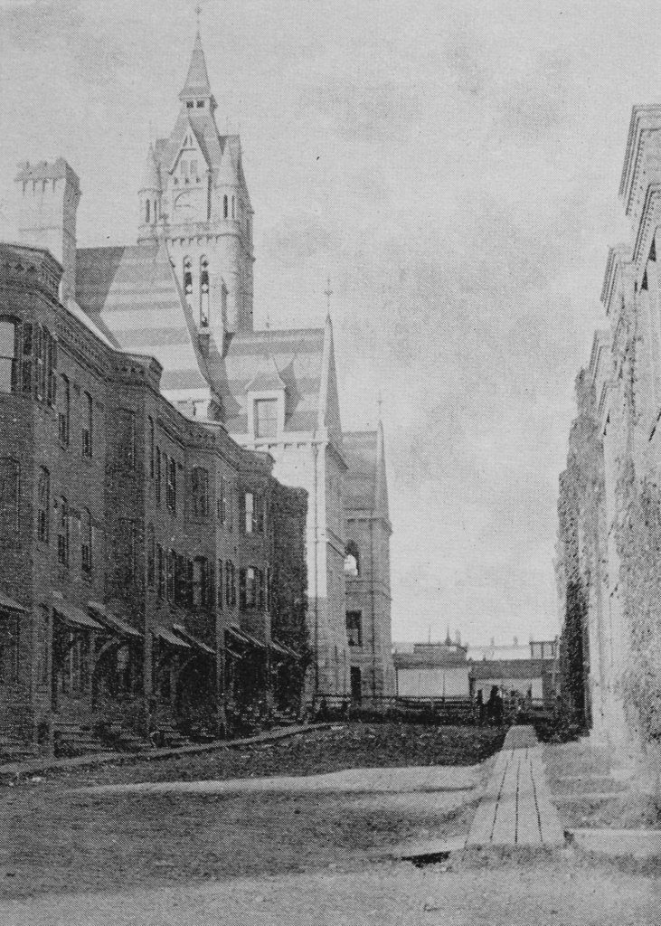
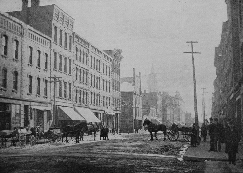
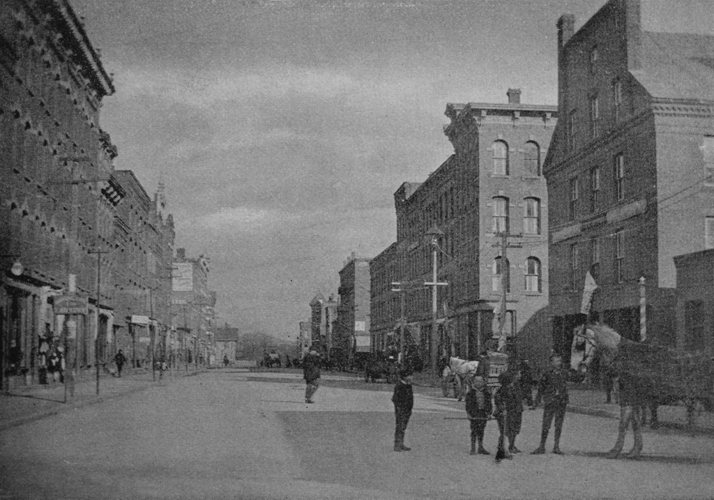
Looking north on Maple Street from the corner of Essex Street in Holyoke, around 1892. Image from Picturesque Hampden (1892).
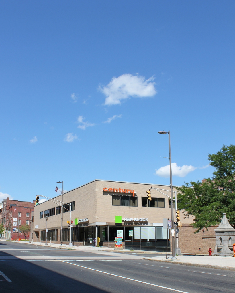
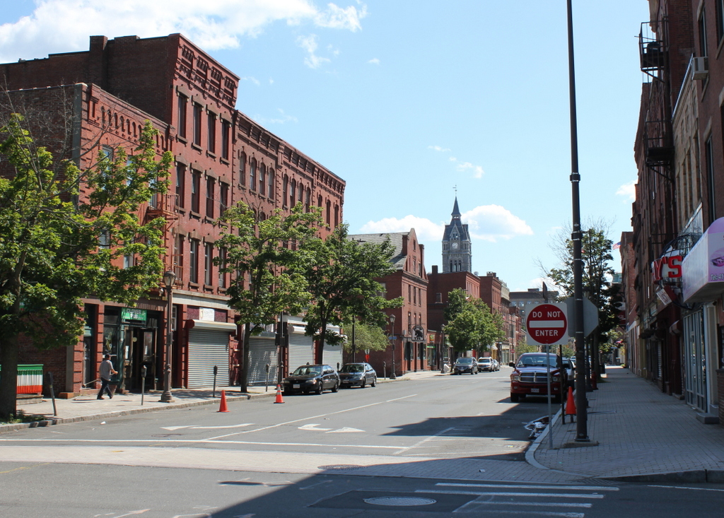
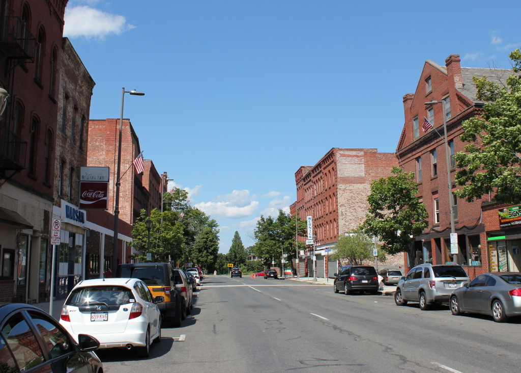
The scene in 2017:

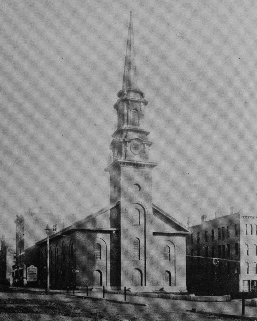
Maple Street runs parallel to High Street, which is located a block to the east. While High Street was developed as a major commercial center, Maple Street was primarily residential in the late 19th century. The first photo shows several homes on the left side, a group of brick rowhouses in the distance on the right, plus two churches closer to the foreground on the right side. Most of these buildings were fairly new when the first photo was taken, and probably none of them had been built before the 1870s. Perhaps the oldest building is the Unitarian Church on the far right, which was built in 1876, although it was significantly expanded in 1889. Further in the distance, near the center of the photo, is the Second Congregational Church, which was built in 1885 after the congregation moved out of its old building at the corner of High and Dwight Streets.

Today, the Second Congregational Church, now the United Congregational Church of Holyoke, is the only noticeable building still standing from the first photo, although most of it had to be rebuilt after a fire in 1919. All of the other 19th century buildings are gone, and today this block includes the 1930 Elks building on the left, the 1936 War Memorial beyond it, and the 1931 New England Telegraph and Telephone Company building on the right, which stands on the site of the Unitarian Church. Further in the distance is a group of early 20th century apartment buildings, and in between is a single 19th century rowhouse, which is barely visible to the left of the church tower. Built around 1880, it is the sole survivor of the long block of rowhouses that can be seen in the first photo, and it is now surrounded on both sides by parking lots.

Newton Place, Holyoke, Mass

Looking north on Newton Place, toward City Hall in Holyoke, around 1892. Image from Picturesque Hampden (1892).

The scene in 2017:

During the second half of the 19th century, brick rowhouses were common in Holyoke, where they housed workers for the city’s many factories. Newton Place, seen here looking north from the corner of Suffolk Street, was a short street directly behind City Hall, and it was lined on both sides with three-story brick rowhouses, which were probably built sometime in the 1870s or early 1880s. The houses were owned by James H. Newton, a prominent industrialist who had helped to transform Holyoke into a major papermaking center. After arriving in Holyoke in 1864, he and his brothers established the Hampden Paper Company, but Newton soon went on to establish six other paper companies. He was also involved in establishing several banks in Holyoke, and he served as the president of the Mechanics’ Savings Bank for 12 years.

Newton still owned these houses during the 1900 census, when he rented them to a variety of people. Unlike the nearby Lyman Mills tenements, which were crowded with newly-arrived Polish immigrants, these rowhouses appeared to have primarily middle-class residents. Many of them had jobs in the paper mills, but there was also a mix of other occupations, including a teacher, a cigar maker, a restaurant owner, a dressmaker, a messenger boy, a blacksmith, a stonecutter, and a telephone operator. The majority of the residents were born in the United States, but there was also a mix of immigrants from Canada, England, Ireland, Italy, and Scotland.

Today, the only building left from the first photo is City Hall, which is hidden from view by the trees on the left side of the photo. Otherwise, nothing is left from the first photo except the street itself, which is now a pedestrian walkway. The houses on the left side were demolished around 1913 to build the City Hall Annex, which still stands today. The houses on the right were demolished at some point afterwards, and the current Holyoke District Court was built on the site in the late 1970s.

High Street and Dwight Street, Holyoke, Mass

The corner of High and Dwight Streets in Holyoke, sometime before 1885. Image from Picturesque Hampden (1892).

The scene around 1891. Image from Holyoke Illustrated (1891).

The scene in 2017:

The first photo shows the Second Congregational Church, which was once located here at the corner of Dwight and High Streets, directly across from City Hall. The church was organized in 1849, and worshiped in several different locations until 1853, when this building was completed, at a cost of $12,000. It was designed by prominent New Haven architect Henry Austin, and was large enough for 800 people, although the congregation only had 36 members at the time. Holyoke was still in the early stages of its industrial development, with a population of a little over 3,000, but over the next few decades both the city and the church saw steady growth. By the mid-1880s, the congregation had outgrown the building, and in 1885 a new church was built a few blocks away, at the corner of Maple and Appleton Streets.

The old church was sold and demolished soon after the new one was completed, and later in 1885 Delaney’s Marble Block was built on the site. The building was owned by John Delaney, and was designed by local architect James A. Clough, with an exterior that was built of Vermont marble. Like many of the other commercial blocks on High Street, the building had stores on the ground floor, with professional offices in the upper floors, and it enjoyed a prominent location at one of the busiest intersections in the city. In later years, the building housed a W. T. Grant store, but around 1950 it was demolished to build a new, more modern-looking building for W. T. Grant. This chain of stores has long since gone out of business, but its architecturally nondescript building still stands here as somewhat of an anomaly, on a street that is otherwise still predominantly lined with 19th century commercial buildings.

High Street from Lyman Street, Holyoke, Mass

Looking south on High Street from Lyman Street in Holyoke, around 1892. Image from Picturesque Hampden (1892).

The scene in 2017:

This scene shows the same block of High Street as this previous post, just from the opposite direction. As mentioned in that post, these buildings were mostly built around the 1860s and 1870s, with the oldest probably being the Fuller Block in the center of the photo, which dates back to around the 1850s. Closer in the foreground, there are seven very similar Italianate-style brick commercial blocks. The six closest to the camera were all built around the same time, probably about 1870, and the one near the center of the photo was built a little later, around 1878. Holyoke’s Gothic-style city hall also dates back to around this time, having been completed in 1876, and its tower rises in the distance of both photos.

Today, this scene has not significantly changed in the past 125 years. Everything on High Street to the north of Lyman Street was demolished in the 1970s as part of an urban renewal project, but most of the historic High Street buildings are still standing to the south of Lyman Street. The Fuller Block is still here, as are most of the other buildings beyond it, and five of the seven buildings in the foreground are also still standing. The building on the far left, at the corner of Lyman Street, is gone, as is the one at the corner of Oliver Street, but otherwise this scene retains much of its late 19th century appearance. Because of this, the buildings along this section of High Street are now part of the North High Street Historic District, which was added to the National Register of Historic Places in 1986.

Oliver Street, Holyoke, Mass

Looking east on Oliver Street from the corner of High Street in Holyoke, around 1892. Image from Picturesque Hampden (1892).

Oliver Street in 2017:

The city of Holyoke became a major manufacturing center in the second half of the 19th century, and among the early corporations here was the Lyman Mills, a cotton company that was established in 1854. The mills themselves were located at the foot of this hill, between the First and Second Level Canals, but the company also built over 200 tenements here on the hill for worker housing. The tenements appear to have been built sometime in the 1850s, and they consisted of brick rowhouses that lined both sides of Oliver and Hampden Streets, as well as the south side of Lyman Street and the west side of Front Street.

The Lyman Mills still owned these tenements when the first photo was taken in the early 1890s. Like most of the other mills in Holyoke, the company relied heavily on immigrant labor, and during the 1900 census, the residents of these Oliver Street tenements were almost entirely Polish immigrants. The census records show a mix of jobs within the cotton mill, with carders and weavers being the most common, and each tenement building typically housed about four to five families, with many families also taking in boarders. For example, the tenement at 24 Oliver Street, the furthest one up the hill on the right side (not counting the Fuller Building on the far right) had four families, with a total of 33 residents, including boarders. All of them, except for the young children, were immigrants, and most had arrived in the United States only a few years earlier.

The Lyman Mills tenements were later owned by the Whiting Paper Company, and they remained in use until the 1930s. However, by this point the neighborhood was deemed to be a slum, and the tenement houses were among some 2,800 Holyoke houses that were found to be substandard in a 1938 survey. As a result, the city demolished the entire area between John and Lyman Streets and redeveloped it as a public housing project, with the newly-established United States Housing Authority paying for 90 percent of the project’s $1.8 million construction costs. The bricks from the old tenement buildings were saved, though, and were incorporated into the construction of the new buildings.

This New Deal-era housing project is still standing here today, and the buildings are still owned by the Holyoke Housing Authority. Further in the distance, many of the former Lyman Mills factory buildings are still standing along the canals, but in the foreground the only building remaining from the first photo is the Fuller Building on the far right side of the photo. This building was probably built in the 1850s, around the same time as the old tenements, and today it bears a badly-faded Coca-Cola ad that is painted onto the brick wall.

High Street from Oliver Street, Holyoke, Mass

Looking north on High Street from near Oliver Street in Holyoke, around 1892. Image from Picturesque Hampden (1892).

The scene in 2017:

As mentioned in the previous post, this section of High Street was developed in the second half of the 19th century as one of the primary commercial centers in Holyoke. Most of the buildings in this scene date to around the 1860s and 1870s, but perhaps the oldest is the Fuller Building, visible on the far right of the scene at the corner of Oliver Street. It was built sometime before 1863, probably around the early 1850s, and is a rare example of Greek Revival architecture in a city that is largely dominated by Italianate-style commercial blocks.

Just beyond the Fuller Building, on the other side of Oliver Street, is the four-story Hutchins House, which was built in 1878. Around the time that the first photo was taken, it was being used as a boarding house, with several stores on the ground floor, including a dress and cloak maker as well as a dry goods store. Just beyond this building is a row of five matching Italianate-style blocks, all of which were built sometime around 1870. The Hutchins House has since been demolished, and the site is now a small parking lot, but the other five buildings are all still standing with few exterior changes since the first photo was taken.

Likewise, the buildings on the left side of the photo also date back to around the 1860s and 1870s, and most of the ones in the foreground still survive, although the one on the far left of the first photo appears to have either been demolished or trimmed down to one story. Otherwise, the only significant change in this scene is further in the distance, beyond Lyman Street. Originally, High Street continued north for two more blocks beyond Lyman Street, ending at the present-day Pulaski Park, but these buildings were demolished in the 1970s as part of an urban renewal project, and today the Echo Hill Townhouses are located on the site.