First Baptist Church, North Adams, Mass

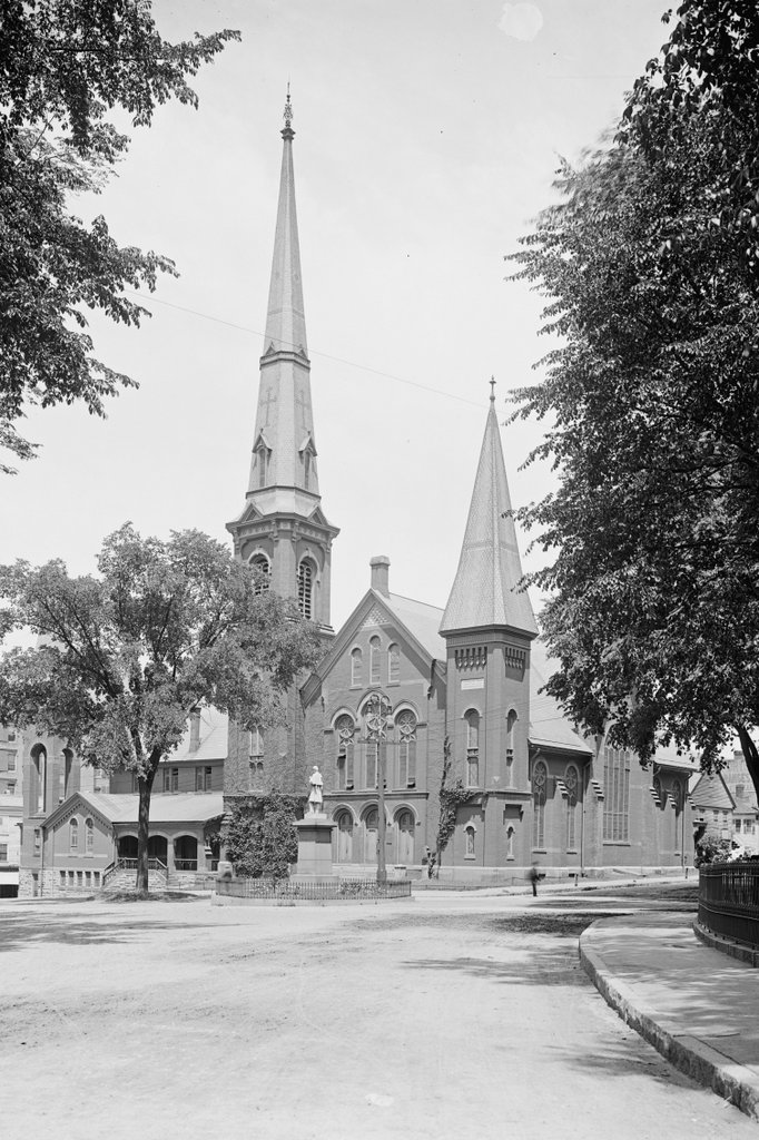
The First Baptist Church, at the corner of Church and Main Streets in North Adams, around 1900-1910. Image courtesy of the Library of Congress, Detroit Publishing Company Collection.
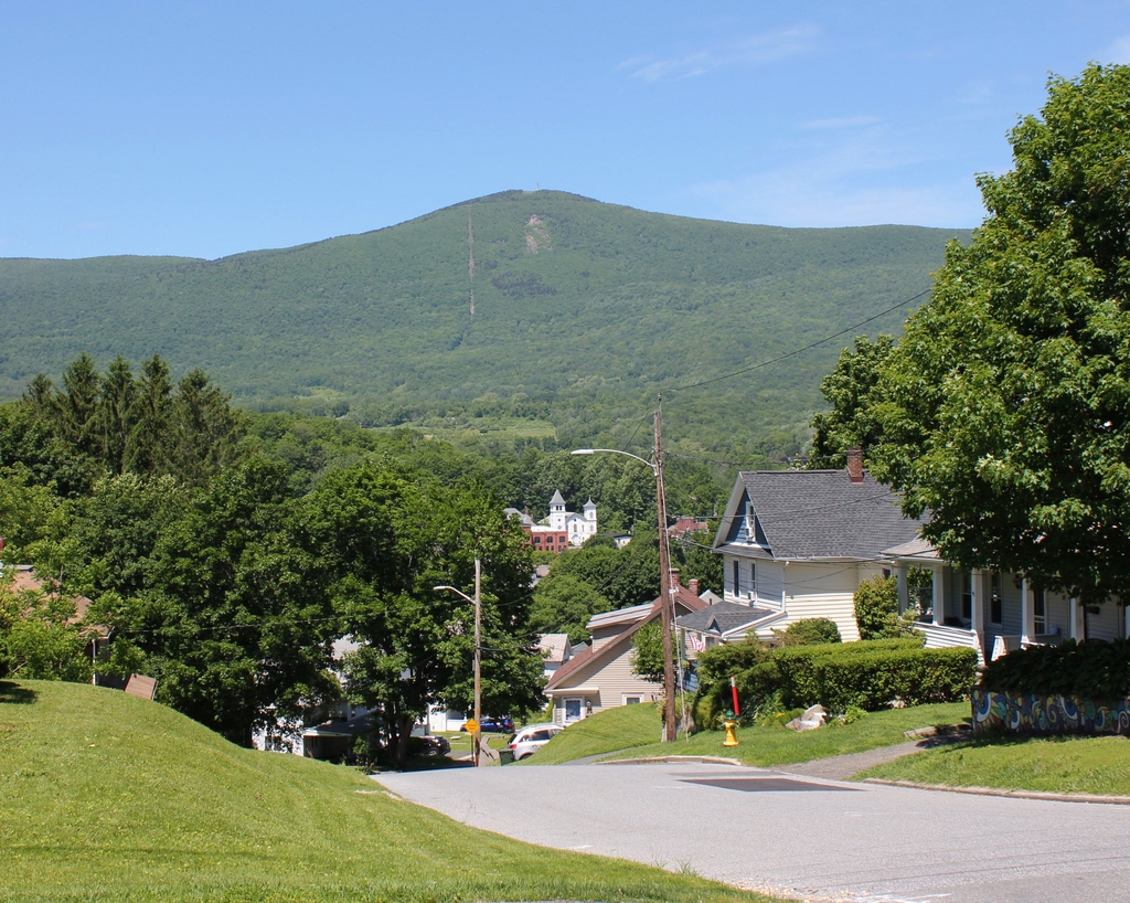
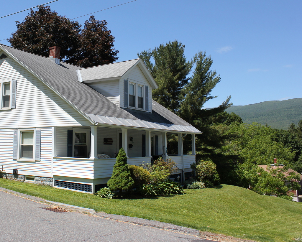
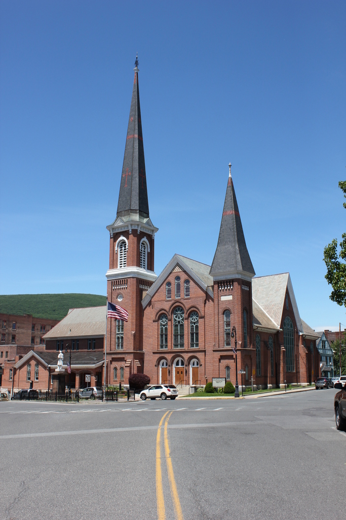
The scene in 2019:

The First Baptist Church was established in 1808, with its parishioners meeting here on this site in a former Congregational church that had been built in 1782. The old building was moved just to the north of here in 1829 and a new one was constructed here. This one was, in turn, replaced by a new one in 1848, which was renovated in 1871 with a new front facade and tower. At the time, present-day North Adams was still a part of the town of Adams, but in 1878 it was incorporated as a separate town, and the church became the First Baptist Church of North Adams.

However, only a year later, on May 5, 1879, the church was destroyed by a fire. The cause of the blaze was never determined, but it started in the organ and burned for at least a half hour before being detected. By the time it was extinguished, most of the building was destroyed, and contemporary newspaper accounts estimated the cost of the damage to be at least $45,000.

Despite the loss, the church was quickly rebuilt here on the same site. The new church may have even incorporated the 1871 front facade and towers, although if so they would have been heavily modified; the earlier church building featured Gothic-style pointed arches, while the rebuilt one has rounded Romanesque arches. The building was dedicated on September 7, 1880, with a series of services that were held throughout the day. In the morning, the Rev. George W. Samson of Harlem preached a sermon on “Strength and beauty are in His sanctuary.” He was followed in the afternoon by the Rev. John B. Brackett of Brookline, who spoke on justification by faith, and the evening service was marked by a sermon from the Rev. A. J. Gordon of Boston, who preached from Psalm 84.

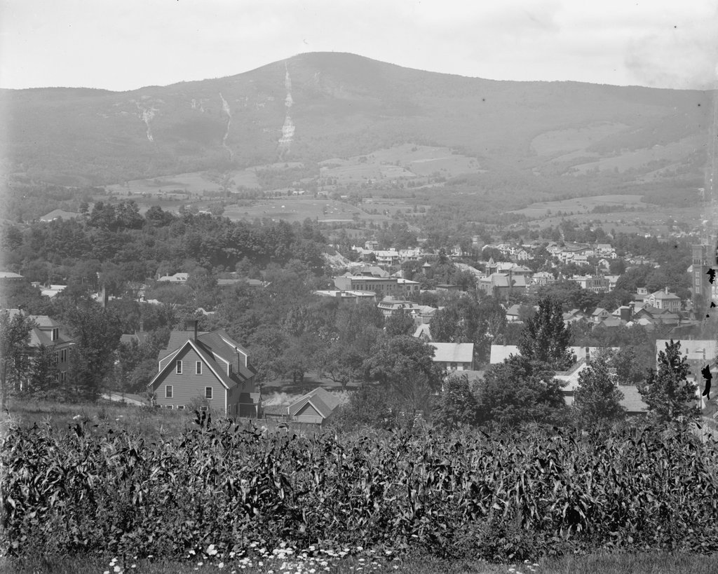
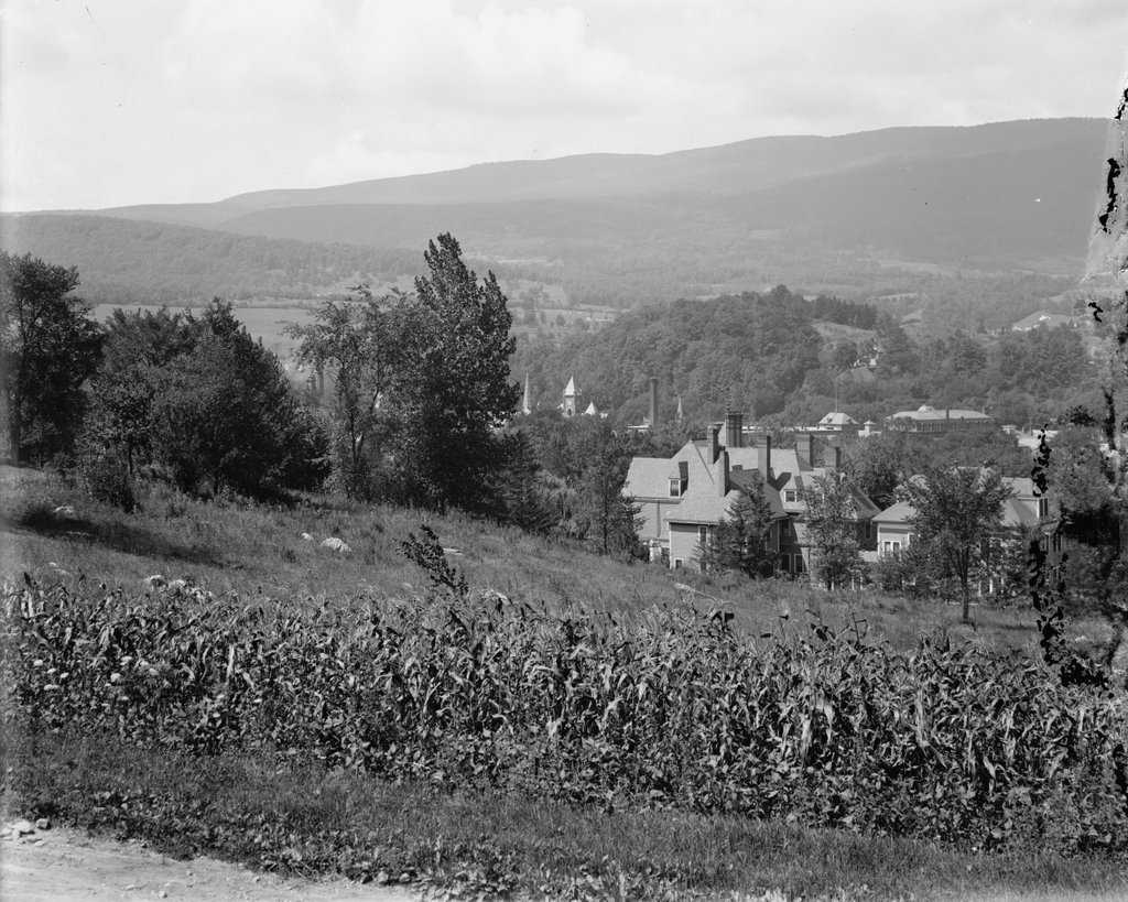
The first photo was taken sometime around the turn of the 20th century, showing the main facade of the church. Directly in front of the church is Monument Square, which features a Civil War statue that was sculpted by North Adams native Charles Niles Pike and dedicated in 1878. Just beyond the church, hardly visible on the far right side of the photo, is the original 1782 meeting house, which was converted into residential and commercial use after being moved in 1829.

Today, very little has changed in more than a century since the first photo was taken. There have been a few small changes to the exterior of the church, including the removal of the small tower on the far left side and the alteration or replacement of the spire atop the tall tower. Otherwise, though, it looks largely the same as it did when it was completed in 1880, and it remains an active Baptist church. The soldiers’ monument is also still standing here in Monument Square, and even the old meeting house behind the church has survived, although it has been heavily altered aver the years. Both of these building, along with a number of others here in downtown North Adams, are now part of the Monument Square–Eagle Street Historic District, which was added to the National Register of Historic Places in 1972.

Randall and Second Streets, Adams, Mass (3)

Looking north on Second Street toward the corner of Randall Street in Adams, around 1900-1915. Image courtesy of the Library of Congress, Detroit Publishing Company Collection.

The scene in 2019:

These photos were taken from the same spot as the ones in the previous post, just facing further to the north. The original photos, including ones featured in blog posts here and here, may have actually been intended as a panorama, because they line up with just a bit of overlap; the duplex on the far left here is the same building on the far right in the previous post.

In any case, these historic photos were taken in the early 20th century, when Adams was a fast-growing factory town. Its population had doubled in the 20 years between 1880 and 1900, and this period saw the development of new residential neighborhood, including these streets on the hillside immediately to the east of the center of town. Some of the houses here had already been built by the time the first photo was taken, but there were sill many vacant lots, and the streets were simply narrow dirt paths.

As mentioned in the previous house, the 1900 census shows that the duplex on the left, at 40-42 Randall Street, was the home of two different families. On the left side was Fred Wilder, a teamster who lived here with his wife Ida, their daughter, and a boarder. The other side of the house was rented by Grace Welch, a 23-year-old woman who lived here with her three children.

Also during the 1900 census, the house in the center of the photo, at 44 Randall Street, was owned by Arthur Randall, whose family may have been the namesake of the street. He was 26 years old at the time, and he, like several of his neighbors, worked as a teamster. At the time, four generations of the family lived here, including Arthur and his wife Azilda, their infant son Everett, Arthur’s father Levi Randall, grandfather Gilbert Harrington, and niece Ella Randall. Levi, who was 58 years old in 1900, worked as a carpenter, and according to the 1904 county atlas he was the owner of the duplex at 40-42 Randall Street.

The other house visible in the first photo is at 14 Second Street, located beyond and to the right of the Randall house. In 1900 it was owned by 43-year-old Marcus Harrington, the uncle of Arthur Russell. He was a blacksmith, and he lived here with his wife Elizabeth and their three children: Walter, Velma, and Earl. According to the 1904 atlas, he also owned the neighboring house at 16 Second Street. However, this house does not appear on the census, so it may have been either unbuilt or vacant in 1900.

Today, more than a century after the first photo was taken, much has changed in this scene. The roads look very different, having been widened and paved, and the exteriors of the houses have also changed, including the removal of the shutters, installation of modern siding, and alterations to the front porches. Overall, though, the turn-of-the-century houses are still standing here, and this scene is still easily recognizable from the first photo.

Randall and Second Streets, Adams, Mass (2)

The view looking northwest from the corner of Randall and Second Streets in Adams, around 1900-1915. Image courtesy of the Library of Congress, Detroit Publishing Company Collection.

The scene in 2019:

These two photos were taken from the same spot as the ones in the previous two posts, which face to the southwest and west. This particular view looks toward the northwest, with the town of Adams in the foreground and the Greylock Range in the distance. The present-day photo does not line up perfectly with the first one, as the line of sight from the original spot is blocked by the house on the far left, but the two photos show the same overall scene, including the two houses on the right side of the first photo, which still stand here in the second photo.

The houses here in the foreground were, for the most part, built around the late 19th century. During this time, Adams was growing in population, becoming an important manufacturing center on the Hoosic River, and residential neighborhoods were steadily making their way up the hillside to the east of town. Many of the house lots were still undeveloped by the time the first photo was taken at the turn of the century, as indicated by the cornfield in the foreground, but most of these would soon have houses on them.

The two houses on the right side of the first photo were both built sometime around 1900, and they are both included in that year’s census. At the time, the one furthest to the right, at 40-42 Randall Street, was occupied by two families. The left side was the home of 34-year-old teamster Fred Wilder, his wife Ida, their daughter Bertha, and a boarder who also worked as a teamster. On the right side was 23-year-old Grace Welch, who lived here with her three children. They ranged in age from 10 months to 7 years, and according to the census she had been married for nine years. It also listed her as being a widow, although subsequent censuses show her as being married to Melvin Welch, so this part of her record was likely in error.

To the left of the duplex is a single-family home at 38 Randall Street. In 1900 it was owned by Ai Davis, a 47-year-old stonemason who lived here with his wife Nora and their five children, the oldest of whom was 23 and the youngest was 5. Their oldest, Hiram, was a teamster, and two other children were listed as attending school. Like her neighbor Grace, Nora had also apparently married very young, because she was 39 years old in 1900 and had already been married for 24 years.

Further in the distance, the most visible building in downtown Adams is the Berkshire Cotton Manufacturing Company. Founded in 1889, the company grew quickly over the next few decades, and by the time the first photo was taken in the early 20th century it consisted of a large factory complex with a number of buildings in the center of the scene. In 1904, the company had around 2,400 people, making it a significant employer in a town that, at the time, had around 12,000 residents.

In more than a century since the first photo was taken, many changes have occurred here in this scene. The cornfield in the foreground is gone, having been replaced by the house on the far left side at some point around the 1920s. In the distance, the slopes of Mount Greylock are now far more wooded than they had been in the first photo, and much of downtown Adams is also now obscured by trees. The houses at 38 and 40-42 Randall Street are still standing though, as are some of the buildings in the Berkshire Cotton Manufacturing Company complex.

During the 20th century, Berkshire Cotton Manufacturing went through a series of mergers in the 20th century, eventually merging with Hathaway Manufacturing in 1955 to become Berkshire Hathaway. It continued to produce textiles here into the second half of the 20th century, and came under the control of a young Warren Buffett in 1965. The factory ultimately closed, and many of the buildings have since been demolished, but the company itself still exists. No longer a small-town cotton mill, Berkshire Hathaway is now a major multi-national holding company headquartered in Omaha, although its name continues to serve as a reminder of its origins here along the Hoosic River in Adams.

Mount Greylock from Adams, Massachusetts

The view of Mount Greylock as seen from the corner of Randall and Second Streets in Adams, around 1900-1915. Image courtesy of the Library of Congress, Detroit Publishing Company Collection.

The scene in 2019:

These two images do not line up perfectly; the first one was taken a few yards to the south of where the 2019 one was taken. However, the view from that spot is now blocked by a house that stands where the cornfield in the foreground used to be, so the present-day photo was taken a little closer to the corner of Randall Street. However, the overall scene is the same in both photos, showing the town of Adams at the bottom of the hill, with the summit of Mount Greylock as the backdrop in the distant center.

Standing 3,491 feet above sea level, Mount Greylock is the highest point in Massachusetts. It is part of the Taconic Mountains, a range within the Appalachians that runs roughly along the New York-Massachusetts border, and it is also one of the most topographically-prominent mountains in New England, rising nearly 2,500 feet above all of its surrounding valleys. As a result, it is visible for miles in every direction, and it is the most distinctive landscape feature within the town of Adams.

The east slope of the mountain, shown here in this scene, is its steepest. From the summit, it drops more than 2,700 feet in less than three miles to the floor of the Hoosic River valley. The town of Adams was settled here along the river, and during the second half of the 19th century it developed into a thriving industrial community. The town was divided in half in 1878, with the more populous northern half becoming North Adams, but Adams continued to grow, and by the time the first photo was taken at the turn of the 20th century its population had risen to over 10,000 residents.

The photo shows the downtown area of Adams, as seen from the hills immediately to the east. By this point, this area was in the process of being developed for housing, and the 1904 county atlas shows that the land in the foreground had already been subdivided into individual lots. Some of the houses had already been built by then, but other lots were still vacant, including the cornfield here in the first photo. However, within a decade or two this site would also be developed, and there is now a 1920s-era house that stands just out of view on the left.

Today, Adams is no longer a major factory town, and its population is actually smaller than it was at the turn of the last century. Overall, though, this view is not significantly different from the first photo. Probably the single most noticeable change is the increased number of trees. In the foreground, downtown Adams is mostly hidden by the trees, although there are several buildings visible, most notably the First Congregational Church, which stands in the center of the scene. Beyond the town, the slopes of Mount Greylock are much more wooded today than in the first photo, and at the summit is the Veterans War Memorial Tower, which was dedicated in 1933 in memory of Massachusetts residents who died in World War I.

Randall and Second Streets, Adams, Mass

The view looking southwest from the corner of Randall and Second Streets in Adams, around 1900-1915. Image courtesy of the Library of Congress, Detroit Publishing Company Collection.

The scene in 2019:

During the late 19th and early 20th centuries, the Berkshires became an important industrial center, with a number of factories located along the Housatonic and Hoosic Rivers. Here in Adams, near the northwest corner of Massachusetts, the town saw rapid growth during this period because of its industries. It lost nearly two thirds of its population in 1878 when its northern half was partitioned off as the town of North Adams, but over the next 20 years it doubled in population, ultimately reaching its peak at just over 13,000 people by 1910.

The first photo was taken around this time, facing southwest from the hillside just to the east of the center of town. A portion of downtown Adams is visible in the distance, including the steeple of First Baptist Church, which stands in the center of the photo. Further beyond the town is the southern end of the Greylock Range, which features the tallest mountains in the state. The highest, Mount Greylock, is just out of view on the far right side, but the state’s second-highest peak, Saddle Ball Mountain, is evidently visible in this scene.

In the foreground of the first photo is a corn field. At the time, this neighborhood was only partially developed, consisting of a few late 19th century homes interspersed with empty lots such as this one. However, by this point the area was already eyed for future development, with the 1904 county atlas showing that this land had already been subdivided into new streets and house lots, which were owned by the Bonnie Brae Land Company. Many of the houses and streets were ultimately never built, perhaps because the population of Adams plateaued after 1910, but this former corn field was developed sometime after the first photo was taken. As shown in the present-day scene, it is now the site of a bungalow-style house that, based on its architecture, was probably built sometime around the 1920s.

Burbank House, Springfield, Mass

The house at 330 Park Drive in Springfield, around 1938-1939. Image courtesy of the Springfield Preservation Trust.

The house in 2019:

This house is located in Colony Hills, an upscale residential neighborhood that was developed starting in the 1920s. The area is located just to the south of Forest Park, where it straddles the border of Springfield and Longmeadow. The Springfield side, where this house is located, is unusual in that it consists of two separate sections that are effectively enclaves of the city. They are surrounded on three sides by Forest Park, and on the fourth side by the Longmeadow border, so there is no direct road connection between Colony Hills and the rest of Springfield without passing through Longmeadow. As a result, the neighborhood is quiet and isolated from the rest of the city, making it a particularly desirable place to live.

About half of the houses on the Springfield side of the neighborhood are on Park Drive, which runs along part of the perimeter of Forest Park. Of these, this house has perhaps the most desirable location. The property lies in the center of a horseshoe-shaped curve, so it is almost entirely surrounded by wooded parkland, with no other homes visible from the front yard. The house itself was built in 1929, and it features a Tudor Revival design that was typical for upscale homes of this period. It was the work of Max Westhoff, a local architect who also designed similar homes on Maple Street and Longhill Street.

The original owner of this house was Daniel E. Burbank, a real estate investor whose properties included the Hotel Worthy in downtown Springfield. He ran a real estate business here in Springfield, but in 1932 he also became the real estate consultant for the Bickford’s restaurant chain, along with serving as one of the company’s directors.

Burbank was not living in this house during the 1930 census, but he and his family evidently moved in soon afterward. The first photo was taken sometime around the late 1930s, and the 1940 census shows Burbank living here with his wife Helen and their children Daniel Jr., Lyman, Barbara, and David. At the time, the house was valued at $50,000, or nearly $1 million today, and Burbank’s income was listed at over $5,000, which was the highest income level on the census.

Helen Burbank died in 1948, but Daniel continued to live here until his own death in 1960, at the age of 77. Later that year, the house was sold to Joseph J. Deliso, an industrialist who was, at the time, president and treasurer of the Hampden Brass & Aluminum Company, and president of the Hampden Pattern & Sales Company. Deliso has previously lived in a different Westhoff-designed house at 352 Longhill Street, and he went on to live here in this house on Park Drive for the rest of his life.

During this time, Deliso was instrumental in establishing Springfield Technical Community College after the closure of the Armory, and he was the first chairman of the STCC Advisory Board, serving from 1967 to 1981. He subsequently became the first chairman of the STCC Board of Trustees, and in 1992 one of the buildings on the campus was named Deliso Hall in his honor.

Deliso died in 1996, and a year later the house was sold to the Picknelly family, owners of the Peter Pan Bus Lines. The property is still owned by the Picknellys today, and the house remains well-preserved, with few exterior changes from this view aside from an addition on the far left side. It is now the centerpiece of the Colony Hills Local Historic District, which was established in 2016 and encompasses all of the historic homes on the Springfield side of the neighborhood.