William Cullen Bryant Homestead, Cummington, Mass

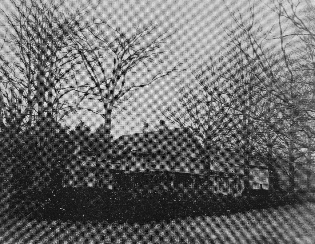
The William Cullen Bryant Homestead on Bryant Road in Cummington, around 1890. Image from Picturesque Hampshire (1890).
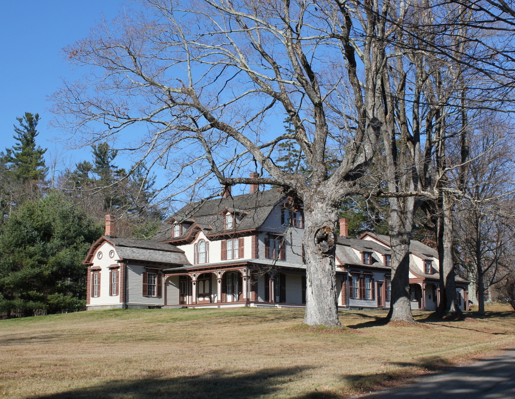
The scene in 2020:

These two photos show the childhood home—and later the summer home—of William Cullen Bryant, a prominent 19th century poet and newspaper publisher. The house was built in 1783 by his grandfather, Ebenezer Snell, who had moved to Cummington from North Bridgewater a decade earlier. At the time, Cummington was a small, remote settlement in the Berkshire Mountains, located along upper reaches of the north branch of the Westfield River. The first colonial settlers did not arrive here until 1762, and it was not formally incorporated as a town until 1779.

Ebenezer Snell and his wife Sarah were both in their mid-30s when they moved to Cummington. They brought four young children with them, including William Cullen Bryant’s mother Sarah, and they subsequently had a fifth child while living in Cummington. By the time they moved into this house in 1783, the younger Sarah was about 15 years old. She continued living here as an adult, and in 1792 the family took in a boarder, Dr. Peter Bryant. Like the Snell family, he was from North Bridgewater, and he he was a year older than Sarah.

According to tradition, Peter Bryant had fallen in love with Sarah while the Snells were still in North Bridgewater, and he subsequently followed them here to Cummington. This seems rather improbable or exaggerated, since he and Sarah were about five or six years old when the Snells left North Bridgewater. Either way, though, Peter and Sarah soon fell in love here in Cummington, and they were married in October 1792. They subsequently moved into their own house in town, where their first child, Austin, was born six months after their marriage.

Peter and Sarah’s second child was William Cullen Bryant, who was born at their home on November 3, 1794. Soon after, the family suffered financial trouble after Peter lost money in a risky investment. They lived in the nearby town of Plainfield for several years, and they ultimately moved in with Sarah’s parents here at their home in Cummington in the spring of 1799, when William Cullen Bryant was four years old.

The move here to the family homestead proved to be a transformative experience for the future poet. The house is located about two miles west of the town center, on a northeast-facing slope that overlooks the Westfield River Valley. The land around the house was mostly open fields and pastureland, but the outlying portions of the property were largely forested. Most famously, this included the Rivulet, a stream that flows past the house and through an old growth forest on the northeastern edge of the lot. This stream was a favorite childhood haunt of Bryant, who wrote some of his earliest lines of poetry along its banks, and he later memorialized it in his poem “The Rivulet.”

Writing many years later in 1872 in a letter to a friend, Bryant provided the following description of the landscape surrounding his childhood home:

The site of the house is uncommonly beautiful. Before it, to the east, the ground descends, first gradually, and then rapidly, to the Westfield River flowing in a dep and narrow valley, from which is heard, after a copious rain, in the roar of its swollen current, itself unseen. In the spring-time, when the frost-bound waters are loosened by a warm rain, the roar and crash are remarkably loud as the icy crust of the stream is broken, and the masses of ice are swept along by the flood over the stones with which the bed of the river is paved. Beyond the narrow valley of the Westfield the surface of the country rises again gradually, carrying the eye over a region of vast extent, interspersed with farm-houses, pasture-grounds, and wooded heights, where on a showery day you sometimes see two or three different showers, each watering its own separate district; and in winter-time two or three different snow-storms dimly moving from place to place.

Peter Bryant practiced medicine in an office here in this house, and during the early 19th century he achieved some success as a politician. In 1806 he was elected to a one-year term in the state house of representatives, and he subsequently served in that same capacity in 1808, 1809, and 1813, before serving in the state senate in 1818 and 1819.

Throughout this time, Peter Bryant was a staunch Federalist, and he instilled these political beliefs in young William. Although he would become famous for his nature poetry, some of William Cullen Bryant’s earliest poems were political. Among these was “The Embargo,” a satire that criticized Thomas Jefferson and the financial crisis caused by his infamous Embargo Act of 1807. Published in 1808 when Bryant was just thirteen, the poem is more than 500 lines in length. In one particularly scathing stanza, Bryant declared Jefferson to be “scorn of every patriot name, / Thy country s ruin and thy council s shame!” Bryant even alluded to the rumors about his affair with Sally Hemings, telling Jefferson to “sink supinely in her sable arms; / But quit to abler hands the helm of state.”

This poem and other similar politically-charged works would later become a source of some embarrassment for Bryant once he matured, but these poems earned him some notability as promising young poet. Although its reviewer disagreed with Bryant’s critical stance on Jefferson, the Monthly Anthology nonetheless admired his talents, declaring that “[w]e have never met with a boy of that age who had attained to such a command of language and to so much poetic phraseology.”

However, despite this early talent as a poet, Bryant’s career goal was to become a lawyer. To that end, he enrolled in Williams College in 1810 at the age of 16, but left at the end of the school year. He intended to continue his studies at Yale, but his father’s still-precarious financial situation forced him to change his plans. Instead, he read law—essentially a legal apprenticeship—with two different lawyers, and he was ultimately admitted to the bar in 1815.

Bryant began his legal career in Plainfield, but he continued to live here at the family homestead for a year, walking seven miles a day in each direction to get to his office. Then, around 1816 he moved to the much larger town of Great Barrington in the southwest corner of the state, where he practiced law for the next nine years. However, he was still publishing poetry during this time, including his most famous poem, “Thanatopsis.” Bryant had actually written the poem around 1811 when he was just 17, but it was published in 1817 and eventually became Bryant’s most significant contribution to the American canon of literature. The poem approaches death from a naturalistic perspective, describing how death is not something to be feared since the body becomes part of the natural world. The poem includes many vivid descriptions of nature, which were likely influenced by Bryant’s time here at the homestead in Cummington.

“Thanatopsis” would prove to be the high point of Bryant’s career as a poet, but he subsequently went on to achieve prominence as a newspaper editor. Having grown tired of Great Barrington, Bryant moved to New York City, where he worked as a magazine editor before becoming editor-in-chief of the New York Daily Post in 1829. He would go on to hold this position for the next half century, until his death in 1878. Throughout this time, the Post was one of the nation’s leading newspapers, and he used the paper to advocate for liberal causes such as abolitionism, organized labor, and immigrant rights. In 1860, he played an important role in Abraham Lincoln’s nomination, using his influence to generate support in the eastern states for the relatively obscure former congressman from Illinois.

In the meantime, the rest of the Bryant family also began to look beyond the old family homestead here in Cummington. Just as Ebenezer Snell had moved his family west from North Bridgewater in the 1770s, the later generations of his family also saw greater opportunities further to the west. Farming was difficult in the rocky, mountainous hill towns of western Massachusetts, and many families were drawn to the newly-formed territories and states, lured by promises of better farmland and greater opportunities. Many of these towns experienced population loss in the mid-19th century, including Cummington, which peaked in population in 1830 with 1,261 residents, before entering a 90-year decline. By 1920, the town had barely a third of its 1830 population, and experienced only moderate growth in the second half of the 20th century. Even today, the population of Cummington and many other hill towns is substantially lower than it was in the mid-19th century.

Among those who joined the exodus from Cummington were William Cullen Bryant’s younger brothers Arthur, John, and Cyrus, who moved away in the early 1830s and eventually made their way to Illinois. This left only the eldest brother Austin here at the homestead with their widowed mother Sarah, who continued to struggle financially and fell into debt. William helped with the interest payments on the loans, but Sarah and Austin ultimately decided to sell the property in 1835, much to William’s disappointment.

The new owner of the house was Welcome Tillson, a farmer who was in his mid-30s at the time. He lived here for the next 30 years, and at some point during this time he removed the wing that had once housed Bryant’s father’s office. This small piece of the building was, according to Bryant, subsequently moved down the hill to the banks of the Westfield River. During the 1860 census Welcome and his wife Sarah were in their late 40s, and were living here with their 28-year-old son Cyrus and his wife Elizabeth. He owned about 500 acres of improved land and 35 acres of unimproved land, and his agricultural output in 1860 consisted primarily of butter, cheese, wheat, corn, oats, potatoes, and maple syrup.

In 1865 Bryant, who was now 70, purchased the property from Tillson for use as a summer home. It was also intended to serve as a place of quiet rest for his wife Frances, who was in poor health. He soon set about making renovations, including adding a third story by raising the original section of the house and then constructing a new first floor underneath it. Bryant also added a replica of his father’s office to the southwest corner of the house. This one-story wing served as Bryant’s study, and it is visible on the left side of both photos here. However, Frances Bryant did not live long enough to see these renovations completed; she died in July 1866, just a year after her husband purchased the house.

Aside from these changes to the house, Bryant also made improvements to the grounds, including planting some 1,300 apple trees and a variety of other fruit trees. Immediately to the west of the house, in the distance of the first photo, Bryant planted a row of pine trees to act as a wind break, and further down the hill from here he built a small pond to serve as a source of ice that could be harvested and stored for the summer. In addition, he made two different additions to the barn on the other side of the street, first in 1866 and then in 1875. This barn had been built by Welcome Tillson after he purchased the property, replacing an earlier one that Peter Bryant had constructed on the same site in 1801.

Bryant continued to spend his summers here in Cummington for the rest of his life, generally arriving in late July and staying until early September. He died in New York City on June 12, 1878 at the age of 83, but this property remained in his family for several more generations. His younger daughter Julia inherited the house, and she owned it when the first photo was taken around 1890, although she spent most of her later years in Paris, where she lived with her cousin and presumed romantic partner, Anna Fairchild.

Julia died in 1907 and left this house to Anna Fairchild, who owned it until 1917, when she sold it to Julia’s niece Minna Godwin Goddard, who was the daughter of Bryant’s older daughter Frances. Minna then owned it until her own death in 1927, and in her will she left the property to the Trustees of Reservations, with the stipulation that her son Conrad would have life tenancy rights. The family also donated furniture and other items to the Trustees, and in 1931 Conrad built a caretaker’s house to the north of the main house, just out of view on the far right side of this scene.

Today, nearly a century after the Minna Goddard left this property to the Trustees and more than 230 years after her great-great grandfather Ebenezer Snell built the house, this house is still standing as an important historic landmark. As shown in these two photos, very little has changed here in this scene since the first photo was taken around 1890. Even some of the trees are still standing from the first photo. The three large maples in the foreground are the same ones from the first photo, and they were originally planted here in the early 19th century by the Bryant family.

The Bryant Homestead is still owned by the Trustees, which owns a number of other historic sites and conservation areas throughout Massachusetts. Here in Cummington, this property features not only the historic house but also nearly 200 acres of surrounding land. Several hiking trails wind through this landscape, including one that runs alongside the Rivulet, through the same old growth forest that first inspired Bryant more than two centuries ago. Overall, the homestead looks much the same as it did when Bryant acquired it in 1865, and it is one of the many important literary landmarks here in New England.

Old Bacon Academy, Colchester, Connecticut

The Bacon Academy building at 84 Main Street in Colchester, around 1896. Image from Connecticut Quarterly.

The building in 2020:

Bacon Academy is one of the oldest public high schools in the United States, and the second oldest in Connecticut. It was established in 1803 following the death of Pierpont Bacon, a Colchester resident who bequeathed $35,000 to maintain a school for the town’s residents. At the time, a high school education was rare in the United States, and few towns had a high school, even here in the relatively well-educated northeast. For Bacon Academy, the main purpose was to prepare boys for college, so the school offered what was, at the time, regarded as a well-rounded education. An 1803 newspaper advertisement declared that students would “be accommodated with suitable instruction in Reading, Writing, Arithmetic, the learned Languages and Sciences.” Tuition in 1803 was $2.00 per quarter in the summer, and $2.50 per quarter in the winter.

The school opened on November 1, 1803, here in this brick, three-story Federal-style building. It is situated right in the center of Colchester, on Main Street directly opposite Norwich Avenue. Behind the school, visible in the distance on the left side of the scene, is the town’s old burying ground, which dates back to 1713. The opening of the school was widely reported in newspapers across the region, and the New York Morning Chronicle provided the following description of the building and its location:

A large and elegant brick building is erected for the accommodation of the scholars; being 75 feet in length, 34 feet in breadth, and three stories high. It is divided into a large hall, and convenient apartments for the different branches. . . . Colchester is a very healthy and pleasant town situated on the turnpike road leading from Hartford to New-London, being nearly equi-distant from each. A more eligible situation for an institution of this kind, could not have been chosen.

The first principal of the school was 31-year-old John Adams, a Connecticut native and Yale graduate who had previously taught at Plainfield Academy in New Jersey. He went on to become a prominent educator, serving here in Colchester until 1810, followed by 23 years as principal of Phillips Academy Andover. Later in life he moved west, serving from 1836 to 1843 as principal of Jacksonville Female Seminary, a school that would eventually be incorporated into Illinois College in the early 20th century.

During its first year, Bacon Academy enrolled 206 students. The majority of these were from Colchester, but 63 of them were from out of town. In its early years, the school even attracted students from out of state. Perhaps most notably, this included 11-year-old Stephen F. Austin of Missouri, whose father Moses Austin enrolled him in the school starting in the fall of 1804. Stephen Austin attended the school for the next three years, and he would eventually go on to become one of the founders of Texas and the namesake of its capital city.

Aside from Austin, Bacon Academy saw a number of its other students go on to achieve prominence in the 19th century. These included at least five future governors: William Larrabee of Iowa, Edwin D. Morgan of New York, Lyman Trumbull of Illinois, and William A. Buckingham and Morgan Bulkeley of Connecticut. With the exception of Larrabee, all of these men also served as U.S. senators, and Trumbull had a particularly distinguished career in the Senate, serving from 1855 to 1873. During this time, he co-authored the Thirteenth Amendment, which outlawed slavery. Other distinguished Bacon Academy students included Eliphalet A. Bulkeley, who became the first president of Aetna Insurance Company, and Morrison Waite, who served as chief justice of the United States from 1874 to 1888.

By the mid-1830s, the school had grown to 425 students, including 137 who were from out of town and 32 from out of state. For the first few decades, the student body consisted of white males, with a separate school here in Colchester to educate African American children. However, at least one African American, the prominent educator Prince Saunders, was associated with Bacon Academy only a few years after it opened. He ran the African American students, and he is said to have taken courses at Bacon Academy, although it does not seem clear as to whether he was formally enrolled at the school, or was taught outside of school by some of its teachers.

In any case, by the 1840s Bacon Academy was racially integrated, and it had begun to enroll female students. This period in the mid-19th century was a high point for the school, which had aspirations of becoming a top-tier college preparatory school similar to Phillips Academy. However, the school ultimately saw a decline in enrollment, in part because of this deviation from its original mission. Unable to compete with the more established private schools, by the late 19th century Bacon Academy had settled into the role of the public high school for residents of Colchester.

The first photo was taken around the mid-1890s, showing the main academy building in the foreground. On the far right side is Day Hall, an Italianate-style building that was completed in 1858 as a church hall for the adjacent First Congregational Church. By this point, the exterior of the academy had seen a few changes from its original appearance, including the door hood above the main entrance and the octagonal cupola atop the building. The photo shows shutters on the windows and a balustrade along the roof, although these may not have been original either; an 1836 engraving of the building does not show either of these features.

This building remained in use by Bacon Academy until 1962, when the school relocated to a new facility. The school subsequently moved again in 1993, to its current site a few miles to the west of here on Norwich Avenue, where Bacon Academy remains the town’s public high school nearly 220 years after it was first established. In the meantime, the old building here on Main Street is still standing, as is the neighboring Day Hall, which was acquired by the school in 1929. The exteriors of both buildings have remained well-preserved over the years, and the only noticeable difference to the academy building in this scene is the lack of shutters or balustrade. Because of its architectural and historic significance, the building was added to the National Register of Historic Places in 1982. In addition, both it and Day Hall are contributing properties in the Colchester Village Historic District, which was added to the National Register in 1994.

Berkshire Cotton Manufacturing Company, Adams, Mass

Workers outside of the Berkshire Cotton Manufacturing Company, facing east on Hoosac Street at the corner of Depot Street in Adams, in August 1911. Image taken by Lewis Wickes Hine, courtesy of the Library of Congress, National Child Labor Committee Collection.

The scene in 2020:

The first photo was taken in August 1911 by prominent photojournalist and social reformer Lewis Wickes Hine. In the early 20th century, Hine traveled across the country on behalf of the National Child Labor Committee, taking thousands of photos that documented and exposed child labor conditions in factories, mines, farms, and other workplaces. He made several trips to New England during this time, including a lengthy visit in the summer and fall of 1911, when he investigated the region’s prosperous textile industry. Among his stops was the town of Adams in the northwestern corner of the state, where the Berkshire Cotton Manufacturing Company had a large factory complex along the Hoosac River. This photo shows the view looking down Hoosac Street toward the river, with Mill No. 1 in the distance on the left and the corner of Mill No. 3 in the foreground on the right side.

The Berkshire Cotton Manufacturing Company was established in 1889 by the prominent Plunkett family. The family patriarch, William C. Plunkett, had owned several local cotton mills in the mid-19th century, and he also served for two years as the state’s lieutenant governor in 1854 and 1855. He died in 1884, and five years later two of his sons, William and Charles Plunkett, organized the Berkshire Cotton Manufacturing Company. They built a new mill, which became Mill No. 1 here on the left side of the scene. The building featured some 35,000 spindles and 700 looms, but the company quickly outgrew this facility. Just two years later, the company began construction of a second mill directly behind this one, which more than doubled the number of spindles and looms.

The second mill was completed in 1892, and it was dedicated in a ceremony that included a speech by William McKinley, who was then serving as governor of Ohio. McKinley was a close friend of the Plunkett family, who supported his platform of high tariffs to protect American manufacturers. He would later return to Adams several times as president, including in 1897, when he spent the night at William Plunkett’s house and then toured the factory buildings the next day. By this point, the facility had been further expanded with the completion of Mill No. 3, which was built in 1896 on the opposite side of Hoosac Street, as shown in the foreground of the first photo. The company would make one more major addition in 1899, with Mill No. 4, located beyond Mill No. 3 on the other side of the railroad tracks. President McKinley was again on hand for this project, and he laid the cornerstone of the building in June 1899.

McKinley was ultimately assassinated in 1901, but he was commemorated here in Adams with a large statue just around the corner from here, at the intersection of Maple and Park Streets. In the meantime, the Berkshire Cotton Manufacturing Company continued to prosper, thanks in large part to the protective tariffs that McKinley had championed as a congressman and as president. By the turn of the 20th century, the company employed over two thousand workers, representing about half of the town’s entire workforce. The October 1908 issue of the trade journal Textile American included an article about the company, which described the facility as “the largest plant manufacturing fine goods at this time.” These fine goods, according to the article, included “carded and combed cotton goods, comprising lawns, organdies, mulls, India linens, etc.”

The first photo was taken only a few years later, and it was one of at least 25 photographs that Hine took during his visit. Most feature interior scenes of the factory, showing teenagers working as spinners and spooler tenders, among other jobs. He identified the ages of most of these workers, who were typically between 14 and 16 years old. This particular photo was one of the few exterior views that he captured, showing a group of workers gathered around the entrance. He does not provide any ages, but most of the employees appear to be adults, with the exception of the child in the center of the scene. Regarding this child, Hine wrote in his caption:

While I was photographing these workers (Berkshire Mills) the watchman dragged out the smallest boy, saying, “Here, photograph ‘Peewee'” Location: Adams, Massachusetts.

“Peewee” appears in one of Hine’s other photos, were he is sitting on the curb outside one of the factory buildings. Neither caption identifies his name or age, which is somewhat unusual for Hine, who typically provided at least one of these pieces of information about his subjects. However, his appearance is characteristic of many of Hines’s subjects, particularly his small size and his lack of shoes. This is further emphasized here in this photo by contrasting the boy with the otherwise well-shod and relatively well-dressed adults who are gathered around him, laughing and smiling.

It is unlikely that any of the workers in the 1911 photo would have realized it, but by this point the textile industry in New England was nearing its peak, and within the next few decades it would face a steep decline. Much of this was brought on by competition from the southern states, in addition to overseas competition that McKinley and his tariffs had sought to stave off. Many textile companies closed in the 1920s, and those that survived were typically hit hard by the Great Depression of the 1930s.

Berkshire Cotton Manufacturing Company lasted longer than most here in New England, and in 1929 it merged with four other textile companies to form the Berkshire Fine Spinning Associates. In consolidating, the company hoped to be in a better position to compete with southern manufacturers, and over the next few decades it continued to acquire other mills. Most significantly, in 1955 it merged with Hathaway Manufacturing Company of New Bedford, forming Berkshire Hathaway Inc.

Despite these many mergers, though, the textile industry in New England was in an irreversible decline. Berkshire Hathaway produced textiles here in Adams for only a few more years, before ultimately closing these mills in 1958, leaving some 1,200 workers unemployed. The company closed many of its other facilities around this time, before ultimately being acquired by a young Warren Buffett in 1965. Under his ownership, the company steadily moved away from textile manufacturing and into the realm of insurance and finance, eventually becoming the modern-day holding company headquartered in Omaha, Nebraska.

In the meantime, the old Berkshire mills here in Adams were sold off to other owners. Mill No. 2 was demolished in the early 1960s to build a supermarket on the lot, and Mill No. 3 was demolished about a decade later. As shown in the present-day scene, the site of this mill is now a surface parking lot. However, Mill No. 1 is still standing today, partially hidden by trees on the left side, as is Mill No. 4, which stands further in the distance in the right-center of the photo. Mill No. 4 is currently vacant, but No. 1 was repurposed as an apartment building in 1987. Despite these many changes, the building’s exterior has remained well-preserved over the years, and in 1982 it was added to the National Register of Historic Places.

Judges Cave, New Haven, Connecticut

The Judges Cave on West Rock in New Haven, around 1901. Image courtesy of the Library of Congress, Detroit Publishing Company Collection.

The scene in 2019:

The immediate origins of the American Revolution can be traced back to the 1760s, when colonists began protesting taxes that were being levied on the colonies in the aftermath of the French and Indian War. However, this was hardly the first time that the colonies had defied the British crown. A century earlier, following the English Civil War and the eventual restoration of the monarchy, the colony of New Haven protected several regicides who had signed the death warrant of Charles I in 1649. This ultimately helped lead to the downfall of the colony and its merger with Connecticut in 1664, but none of the regicides were ever captured, and the incident has lived on in New England lore.

John Dixwell, William Goffe, and Edward Whalley were three military officers who had fought on the side of Parliament during the English Civil War in the 1640s. Following the defeat of the Royalists, King Charles I was captured put on trial for treason, and was found guilty of being a “tyrant, traitor, murderer and public enemy.” These three men were among the 59 commissioners who signed his death warrant, and he was subsequently beheaded on January 30, 1649.

This led to a decade-long interregnum, during which time Puritan leader Oliver Cromwell took on the title of Lord Protector of the Commonwealth of England. However, this government collapsed soon after Cromwell’s death in 1558, and in 1660 Charles II, the son of Charles I, returned from exile became king. That same year, Parliament passed the Indemnity and Oblivion Act, which pardoned most of the people who took part in the war but specifically excluded the 59 regicides and other high-ranking leaders who were connected to the trial and execution of Charles I. Over the next few years, royal officials tracked down many of these people, who were then imprisoned or executed. Even those who were already dead could not escape punishment; the bodies of Cromwell and several other dead regicides were exhumed from their graves, publicly executed, and then beheaded.

In the meantime, Dixwell, Goffe, and Whalley fled to the New World, to seek shelter among the Puritans. The exact date and location of Dixwell’s arrival is unknown, but he was presumed dead by the British and was not actively pursued by royal authorities. As for Goffe and Whalley, they arrived in Boston in July 1660, and they lived openly in Cambridge, before news of the Indemnity and Oblivion Act reached the colony in the fall. Over the next few months, the colonial leaders debated what to do about the two men. Although many were sympathetic to them and their cause, they feared the consequences to the colony if they continued to shelter them. So, on February 26, 1661 Goffe and Whalley left Cambridge for New Haven, where they arrived on March 7.

Here in New Haven, the men initially lived with the Reverend John Davenport. However, within a few months they were again in danger. News of their formal arrest warrant, dated March 5, reached New Haven around the end of April. This was soon followed by the arrival of royal officials in nearby Guilford, where they met with Governor William Leete. He managed to delay them in Guilford for several days, allowing Goffe and Whalley to quite literally take to the hills in order to escape arrest.

Goffe and Whalley spent several nights in temporary lodgings, aided by local farmers, before they were brought here to this rock formation on May 15. Although commonly referred to as Judges Cave, it is a cave in only the most generous sense of the word. In reality, it is a pile of boulders that, in a few areas, overhang enough to provide minimal shelter from the elements.  It is located high atop West Rock, a traprock ridge located about three miles northwest of the center of New Haven. At the time, this was a remote, sparsely-settled area, and they were able to live here for nearly a month without being detected.

Throughout this month, Goffe and Whalley received food every day from Richard Sperry, a local farmer who lived about a mile from here. They spent several nights at a nearby house during periods of inclement weather, but otherwise they lived here on the hill, which they named Providence Hill. In the meantime, royal officials were diligently searching for them in New Haven, offering generous rewards for their capture while also threatening Reverend Davenport for having aided them. The two regicides considered turning themselves in, in order to spare the colony any further trouble, but Governor Leete convinced them to remain in hiding. Within a few years, though, New Haven’s aid to the regicides would be a contributing factor in the demise of the colony, which was absorbed by the neighboring Connecticut colony in 1664.

According to legend, it was ultimately not royal officials who drove Goffe and Whalley from this cave, but rather a mountain lion that made an appearance at the entrance to the cave and frightened the two men. They left here on June 11, and lived at two other locations in the vicinity of West Rock for the next few months before finding more permanent lodgings at a house in Milford. They remained at this house for the next two or three years, before eventually moving to Hadley, Massachusetts, where they spent the rest of their lives in safety.

Because of the obvious need for secrecy in the movements of the regicides, there are few contemporary sources to corroborate these events. Perhaps the only primary source document was a diary that Goffe kept from 1660 to 1667, which he wrote in an easily-decipherable shorthand. This diary is now lost to history, but in the mid-1700s it was owned by Thomas Hutchinson, the royal lieutenant governor and later governor of the Province of Massachusetts Bay.

Aside from his role in colonial government, Hutchinson was also a historian, and in 1764 he published The History of the Colony of Massachusetts Bay. This book included an account of the regicides, which was based largely on Goffe’s journal. However, as a loyalist in the years leading up to the American Revolution, Hutchinson took a dim view of the regicides, and this bias is evident in much of his narrative. For example, he emphasizes the role that colonial officials had in trying to apprehend them, in an effort to portray the majority of 17th century New Englanders as having been loyal to the crown

Regardless of the biases, and the fact that it was written a century after the events happened, Hutchinson’s book provides the earliest significant account of the regicides and their flight through New England. The section relevant to their time here at Judges Cave, which is part of a lengthy footnote, reads as follows:

About that time, news came to Boston that ten of the judges were executed, and the governor received a royal mandate, dated March 5, 1660, to cause Whaley and Goffe to be secured. This greatly alarmed the country, and there is no doubt that the court were now in earnest in their endeavours to apprehend them; and to avoid all suspicion, they gave commission and instruction to two young merchants from England, Thomas Kellond and Thomas Kirk, zealous royalists, to go through the colonies, as far as Manhados, in search of them. They had friends who informed them what was doing, and they removed from Mr. Davenport’s to the house of one Jones, where they lay hid until the 11th of May, and then removed to a mill, and from thence, on the 13th, into the woods, where they met Jones and two of his companions, Sperry and Burril, who first conducted them to a place called hatchet-harbor, where they lay two nights, until a cave or hole in the side of a hill was prepared to conceal them. This hill they called Providence hill; and there they continued, from the 15th of May to the 11th of June, sometimes in the cave, and, in very tempestuous weather, in a house near to it. During this time, the messengers went through New-Haven to the Dutch settlement, from whence they returned to Boston by water. They made diligent search, and had full proof that the regicides had been seen at Mr. Davenport’s, and offered great rewards to English and Indians who should give information that they might be taken, but, by the fidelity of these three friends, they remained undiscovered.

Goffe’s journal remained in Hutchinson’s possession until 1765, when his house was ransacked by a Patriot mob in protest of the Stamp Act. The journal was either lost or destroyed in the process, making Hutchinson’s book the only surviving description of its contents. However, at least one other prominent historian, future Yale president Ezra Stiles, had the opportunity to examine the journal before its disappearance. He saw it during a 1763 visit to Hutchinson’s house, and he subsequently wrote his own history of the regicides.

Unlike Hutchinson’s description of the regicides, which fills just seven pages in his massive multi-volume history of the colony, Ezra Stiles published an entire book about their exploits in 1794. Titled A History of Three of the Judges of King Charles I, the book is over 350 pages long, and it relies heavily on oral traditions that were passed down to the descendants of the men involved in helping the regicides. Like Hutchinson’s account, Stiles’s book also has a political slant, although in the opposite direction. Writing just a decade after the American Revolution, in the midst of republican, anti-monarchical sentiment, Stiles viewed the regicides in a positive light, and he even included a chapter in which he justified their actions.

Stiles’s seemingly uncritical use of oral tradition in his book would come under criticism from later scholars, including biographer Edmund S. Morgan. Writing in his 1962 book The Gentle Puritan: A Life of Ezra Stiles, 1727-1795, Morgan asserted that it “represents Stiles at his worst. It is a tedious hodgepodge of fact and fancy, compounded mainly out of dim recollections by old men and women of things their grandfathers had told them fifty years before.” One such recollection, which relates to the Judges Cave, came from an interview with Joseph Sperry, whose grandfather Richard Sperry had aided the regicides in 1661. Stiles provided the following account in his book, including a description of this cave:

In 1785 I visited aged Mr. Joseph Sperry, then living, aged 76, a grandson of the first Richard, a son of Daniel Sperry, who died in 1751, aged 86, from whom Joseph received the whole family tradition. Daniel was the sixth son of Richard, and built a house at the south end of Sperry’s farm, in which Joseph now lives, not a half a mile west from the Cave, which Joseph shewed me. There is a notch in the mountain against Joseph’s house, through which I ascended along a very steep acclivity up to the Cave. From the south end of the mountain for three or four miles northward, there is no possible ascent or descent on the west side, but at this notch, so steep is the precipice of the rock. I found the Cave to be formed, on a base of perhaps forty feet square, by an irregular clump or pile of rocks, or huge broad pillars of stone, fifteen and twenty feet high, standing erect and elevated above the surrounding superficies of the mountain, and enveloped with trees and forest. These rocks coalescing or contiguous at top, furnished hollows or vacuities below, big enough to contain bedding and two or three persons. The apertures being closed with boughs of trees or otherwise, there might be found a well covered and convenient lodgement.

After this description of the cave and its surroundings, he wrote of what he learned from Joseph Sperry:

Here, Mr. Sperry told me, was the first lodgment of the Judges, and it has ever since gone and been known by the name of the Judges’ Cave to this day. Goffe’s Journal says, they entered this Cave the 15th of May, and continued in it till the 11th of June following—Richard Sperry daily supplied them with victuals from his house, about a mile off; sometimes carrying it himself, at other times sending it by one of his boys, tied up in cloth, ordering him to lay it on a certain stump and leave it: and when the boy went for it at night he always found the basons emptied of the provisions, and brought them home. The boy wondered at it, and used to ask his father the design of it, and he saw no body. His father only told him there was some body at work in the woods that wanted it. The sons always remembered it, and often told it to persons now living, and to Mr. Joseph Sperry particularply [sic].

They continued here till 11th of June. Mr. Joseph Sperry told me that the incident which broke them up from this Cave was this, that this mountain being a haunt for wild animals, one night as the Judges lay in bed, a panther, or catamount, putting his head into the door or aperture of the Cave, blazed his eye-balls in such a hideous manner upon them, as greatly affrighted them. One of them was so terrified by this grim and ferocious monster, her eyes and her squawling, that he took to his heels, and fled down the mountain to the Sperry’s house for safety. They thereupon considered this situation too dangerous, and quitted it. All the Sperry families have this tradition.

Aside from the events here in New Haven, the subsequent lives of Goffe and Whalley in Hadley are shrouded in mystery and legend. They lived at the home of the Reverend John Russell, but it appears that most townspeople were unaware of their identities. At some point around 1664, they were reunited with John Dixwell, the third regicide who had fled to New England. He eventually moved to New Haven, where he lived under the name John Davids until his death in 1689. Because the authorities believed that he was dead, he was able to live in relative security, and does not appear to have required the use of this cave or any other improvised shelters.

In the meantime, Edward Whalley died in Hadley around 1675 of natural causes, but Goffe lived long enough to become the subject of perhaps the most memorable regicide legend. According to tradition, at some point in either 1675 or 1676 the town of Hadley was facing an attack by Native Americans during King Philip’s War. The townspeople started panicking, but then an elderly man, identified in the legend as William Goffe, emerged and began to take charge. Some 30 years after he fought the Cavaliers on the battlefields of the English Civil War, he rallied the people and led their defense, and succeeded in saving the town. Then, as suddenly as he had appeared, the “Angel of Hadley” was gone.

As is the case for nearly all of the regicide-related stories, the first published account of the Angel of Hadley did not appear for nearly a century, until Thomas Hutchinson included it in his book in 1764. He included it at the end of his lengthy footnote on the movements of the regicides, writing:

The town of Hadley was alarmed by the Indians in 1675, in the time of publick worship, and the people were in the utmost confusion. Suddenly, a grave elderly person appeared in the midst of them. In his mien and dress he differed from the rest of the people. He not only encouraged them to defend themselves; but put himself at their head, rallied, instructed and led them on to encounter the enemy, who by this means were repulsed. As suddenly, the deliverer of Hadley disappeared. The people were left in consternation, utterly unable to account for this strange phœnomenon. It is not probable, that they were ever able to explain it. If Goffe had been then discovered, it must have come to the knowledge of those persons, who declare by their letters that they never knew what became of him.

Writing in his book 30 years after Hutchinson, Stiles repeats essentially the same account of the incident, although his wording tends to be more explicitly favorable to Goffe. Rather than describing him as “a grave elderly person,” Stiles writes of “a man of a very venerable aspect.” He copies Hutchinson’s wording by saying “the inhabitants could not account for the phœnomenon,” but then added “but considering that person as an Angel sent of God upon that special occasion for their deliverance; and for some time after said and believed that they had been delivered and saved by an Angel.”

Stiles’s romanticized description helped to solidify the idea of the “Angel of Hadley,” and by the early 19th century the story had become a part of early American folklore. In his 1823 novel Peveril of the Peak, Scottish writer Sir Walter Scott alluded to the incident, and in 1829 James Fenimore Cooper included it in his novel The Wept of Wish-ton-Wish. Nathaniel Hawthorne, who was never one to pass up a good story about the Puritans, also took inspiration from it. As a young man, he visited Judges Cave here in New Haven, and one of his early short stories, “The Gray Champion,” was loosely based on the Angel of Hadley legend. In the story, the title character is a shadowy, mysterious figure who embodies the Puritan ancestors of New England. Instead of defending a town against Native Americans, Hawthorne’s hero challenges the authoritarian rule of Edmund Andros in the 1680s. The Gray Champion disappears once the threat to the colony is over, but over the years he continues to make appearances whenever American liberty is at stake, including nearly a century later on the battlefields at Lexington and Bunker Hill.

Although Hutchinson’s and Stiles’s accounts provided plenty of material for 19th century authors, many historians began calling into question the accuracy of these tales, especially the ones that were handed down to Stiles through multi-generational hearsay. Legends such as the Angel of Hadley might very well have some basis in reality, but at this point it is difficult to sort out fact from fiction, given the inherent secrecy involved in the regicides and their activities here in New England. As for the tradition that the regicides spent a month hiding here in this rock formation, it is impossible to state with certainty that this is true. However, this belief does not seem to have been seriously questioned, and it seems plausible that this was, in fact, their hiding place during the spring of 1661.

The first photo was taken around 1901, showing the south side of the rock formation. By this point, the surrounding land was owned by the city of New Haven as part of West Rock Park. In the early 1890s a road was opened up here to the Judges Cave, and then in 1896 a plaque was installed here on the rocks. This plaque, which is visible here on the right side of the scene, commemorates the role that this site played in sheltering the regicides, and it was presented to the city by the Society of Colonial Wars. The formal dedication occurred on October 14, 1896, and it was attended by dignitaries such as Mayor Frederick B. Farnsworth, state adjutant general Edward E. Bradley, future governor Simeon E. Baldwin, and writer Charles Dudley Warner. Along with providing a short description of the regicides, the plaque features the phrase “opposition to tyrants is obedience to God,” which had apparently been inscribed on the rocks here as early as 1803.

Today, more than a century after the first photo was taken, the Judges Cave still looks essentially the same. It is still preserved as parkland, although it was acquired by the state in 1975, and it is now named West Rock Ridge State Park. The Judges Cave remains an important landmark within the park, and the only real difference between these two photos is the loss of the plaque, which was evidently stolen at some point. Its replacement is a somewhat larger plaque on the left side, although it bears the same inscription as the original one. It includes the same closing line about how “opposition to tyrants is obedience to God,” reflecting the beliefs that had led two Puritans across the Atlantic Ocean and to this secluded cave on the fringes of European settlements in the New World.


Meriam’s Corner, Concord, Mass

The view looking northeast at Meriam’s Corner in Concord, with Old Bedford Road to the left and Lexington Road on the right, around 1900. Image courtesy of the Library of Congress, Detroit Publishing Company Collection.

The scene in 2020:

The battles of Lexington and Concord on April 19, 1775 marked the start of the American Revolution, when colonial militiamen resisted British attempts to seize military supplies in Concord. However, the fighting did not consist of a single battle, but rather a series of skirmishes spread out across several towns between Boston and Concord. It began at dawn in Lexington, when about 80 of the town’s militiamen gathered on the town common to confront the advancing British. A tense standoff led to both sides exchanging gunfire, killing eight colonists before the British continued their march to Concord. There, they seized some of the colonial supplies, but their advance was halted at Old North Bridge, where militiamen fired the famous “shot heard ’round the world” and forced three companies of redcoats to retreat.

Up until this point, the day was relatively bloodless for the British, who had one soldier wounded at Lexington, three killed at Old North Bridge, and nine wounded there. They had partially succeeded in their objectives, having destroyed some of the colonial cannons and supplies, but they now found themselves deep in hostile territory, with an ever-increasing number of militiamen streaming in from the surrounding towns. Facing a 17-mile march back to the safety of Boston, the redcoats ate lunch in Concord before leaving the town around noon.

Lt. Colonel Francis Smith, the commander of the British soldiers here, ordered a flank guard to protect the column of redcoats as they marched out of Concord. However, just beyond this intersection the road crosses a small stream, requiring the flank guard to return to the road in order to cross the bridge. At the same time, militiamen from Reading, Chelmsford, and Billerica arrived on scene. Observing that the British were vulnerable to attack without a flank guard, Captain John Brooks of the Reading minutemen ordered his soldiers to open fire, beginning what would soon turn into a long and bloody struggle for the British as they made their way back to Boston.

This intersection is known as Meriam’s Corner because it was the longtime home of the Meriam family, who had lived here since the mid-1600s. By 1775 there were three different houses here that belonged to members of the family, including the one on the left side of these photos. Built around 1705 by Joseph Meriam, it was subsequently owned by his son Nathan, who was living here with his wife Abigail and their children in 1775. Nathan was 54 years old at the time, and he was serving as one of the three town selectmen in Concord. He does not appear to have participated in the fighting here, but accounts of the battle suggest that his house and outbuildings were probably among the structures that the militiamen used for cover when they opened fire on the British column.

Contemporary descriptions of the day’s fighting lack specific details about how the fighting unfolded here at Meriam’s Corner, but several later accounts provide more information. Among these is a letter, written in 1825 by Reverend Edmund Foster, who had been one of the Reading minutemen who fought here a half century earlier. In this letter, he wrote the following, which is quoted from the National Park Service’s Historic Structure Report on the Meriam house:

We rendezvoused near the middle of the town of Bedford; left horses, and marched forward in pursuit of the enemy. A little before we came to Merriam’s hill, we discovered the enemy’s flank guard, of about 80 or 100 men, who, on their retreat from Concord, kept that height of land, the main body [being] in the road. The British troops and the Americans, at that time, were equally distant from Merriam’s corner. About twenty rods short of that place, the Americans made a halt. The British marched down the hill with very slow, but steady step, without music, or a word being spoken that could be heard. Silence reigned on both sides. As soon as the British had gained the main road, and passed a small bridge near that corner, they faced about suddenly, and fired a volley of musketry upon us. They overshot; and no one, to my knowledge, was injured by the fire. The fire was immediately returned by the Americans, and two British soldiers fell dead a little distance from each other, in the road near the brook. The battle now began, and was carried on with little or no military discipline and order, on the part of the Americans, during the remainder of that day. Each one sought his own place and opportunity to attack and annoy the enemy from behind trees, rocks, fences and buildings, as seemed most convenient.

As noted in the letter, the brief exchange of fire here at Meriam’s Corner was only the beginning of what would become an afternoon of guerilla warfare and ambushes on the part of the colonial militiamen. They inflicted particularly heavy casualties less than a mile to the east of here, at a spot now known as the Bloody Angle, where 30 British soldiers were killed or wounded. By the time the column reached Lexington the retreat had turned into a rout, and only the timely arrival of reinforcements from Boston saved the British from total disaster.

The British retreat marked the beginning of the Siege of Boston, which lasted until they evacuated the town 11 months later in March 1776. In the meantime, no further fighting occurred here in Concord for the rest of the war, and life in the town largely returned to normal. Nathan Meriam continued to live here in this house until his death in 1782. His son Ephraim subsequently acquired the property, and it would remain in his family until the death of his son Rufus in 1870. Rufus was a bachelor with no children, and the family sold the house a year later, ending two centuries of Meriam family ownership of this lot.

In 1871, the house was purchased by Thomas and Rose Burke, two Irish immigrants who lived here with their four children. He was a farmer, and he and Rose were still living here when the first photo was taken around 1900. According to that year’s census, all four of their children, who were now adults, were also still here, along with a hired hand who worked on the farm and lived with the family.

The first photo shows the scene looking northeast from the intersection. From here, the road on the left is Old Bedford Road, the route that the Reading minutemen took to get here. Out of view on the right is Lexington Road, which the British took on their way to and from Boston on the day of the battle. In the foreground on the right side of the scene is an inscribed boulder, which was installed in 1885 as part of the commemoration of the 250th anniversary of Concord’s founding. It reads: “Meriam’s Corner. The British troops retreating from the Old North Bridge were here attacked in flank by the men of Concord and neighboring towns and driven under a hot fire to Charlestown.”

Today, around 120 years after the first photo was taken, this scene has not changed substantially, except for the paved roads and increase in vegetation. The commemorative boulder is still there, as is the Meriam House in the distance, although it is now mostly hidden by trees from this angle. This site, along with much of the land surrounding the historic Battle Road, is now preserved and administered by the National Park Service as part of the Minute Man National Historical Park, which was established in 1959.