Wells Adams House, Boston

Looking up Salem Street from the corner of Cooper Street, in Boston’s North End, before 1894. Photo courtesy of Boston Public Library.

The same scene in 2014:

The building in the first photo was known as the Wells Adams House, and according to late 19th century sources was built sometime in the late 1600s, probably around the same time as the Paul Revere House.  Like many other historic colonial-era North End buildings, it was demolished in 1894, and the current building was probably built shortly after that.  The only building that appears in both photos is the one on the far right; it was built in the 1840s, and is one of the few bow fronted houses that remains in the North End.

Corner of Lewis & North Streets, Boston

The eastern corner of Lewis and North Streets in Boston’s North End, sometime in the 1860s. Photo courtesy of Boston Public Library.

270_1860sc-bpl

The street corner in 2014:

This ancient building in the first photo probably dated to the early 18th century, but it didn’t last for too long after the photo was taken.  The present-day building on the site was completed around 1874, so the days were numbered for the old building by the 1860s.  At that time, the North End was somewhat of a slum, and the building itself looked like it wasn’t in the greatest condition (note the broken windows on the second floor), so its demolition and replacement was probably hailed as a 19th century version of urban renewal.


Ebenezer Hancock House, Boston

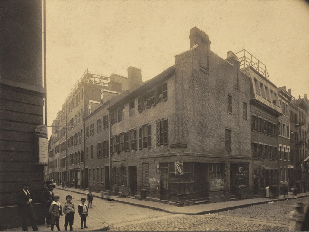
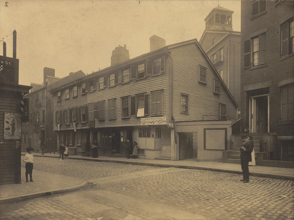
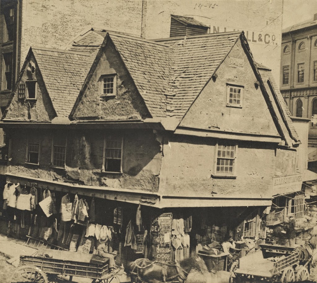
The Ebenezer Hancock House in Boston’s Blackstone Block, before 1886. Photo courtesy of Boston Public Library.
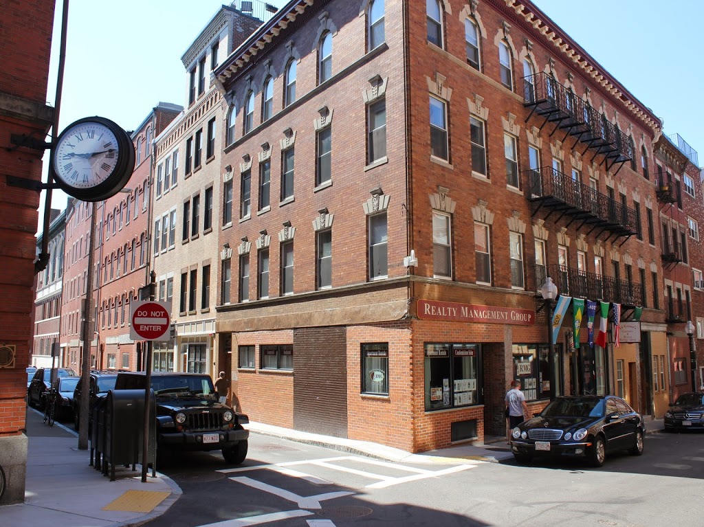
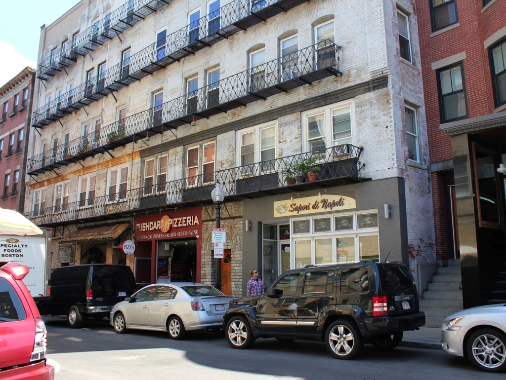
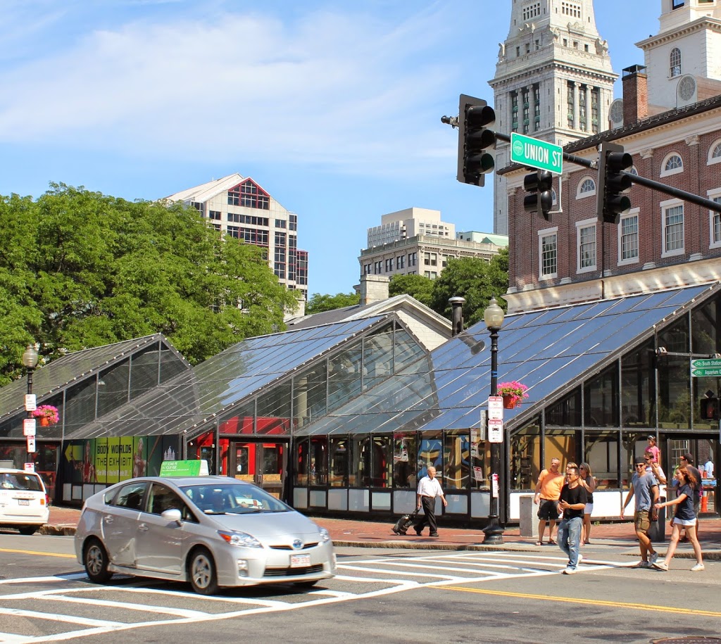
269_1800sc-bpl

The scene in 2014:

269_2014

Boston’s Blackstone Block is in an odd location; the collection of historic 18th and 19th century buildings and narrow, 16th century alleys sits as sort of a time capsule, surrounded by modern development.  On one side is the Government Center area, where street scenes like this were demolished wholesale and replaced with concrete monoliths and open paved areas, and on the other side is the Central Artery, where the elevated highway was originally built in the 1950s before being put underground as part of the Big Dig.

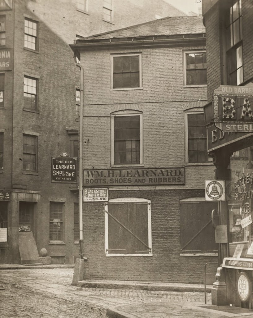
However, the Blackstone Block appears virtually unchanged in over 125 years.  A few notable landmarks are visible in these photos, including the Ebenezer Hancock House in the center.  In the 19th century, it was home to William H. Learnard’s shoe store, who operated out of the building from the 1820s until 1886.  He wasn’t the only person to own a shoe store here, though.  The building functioned as a shoe store from 1798 until 1963, and is today used for offices.  Originally, though, it was a house, and was built around 1767 and later owned by Ebenezer Hancock, the brother of John Hancock.

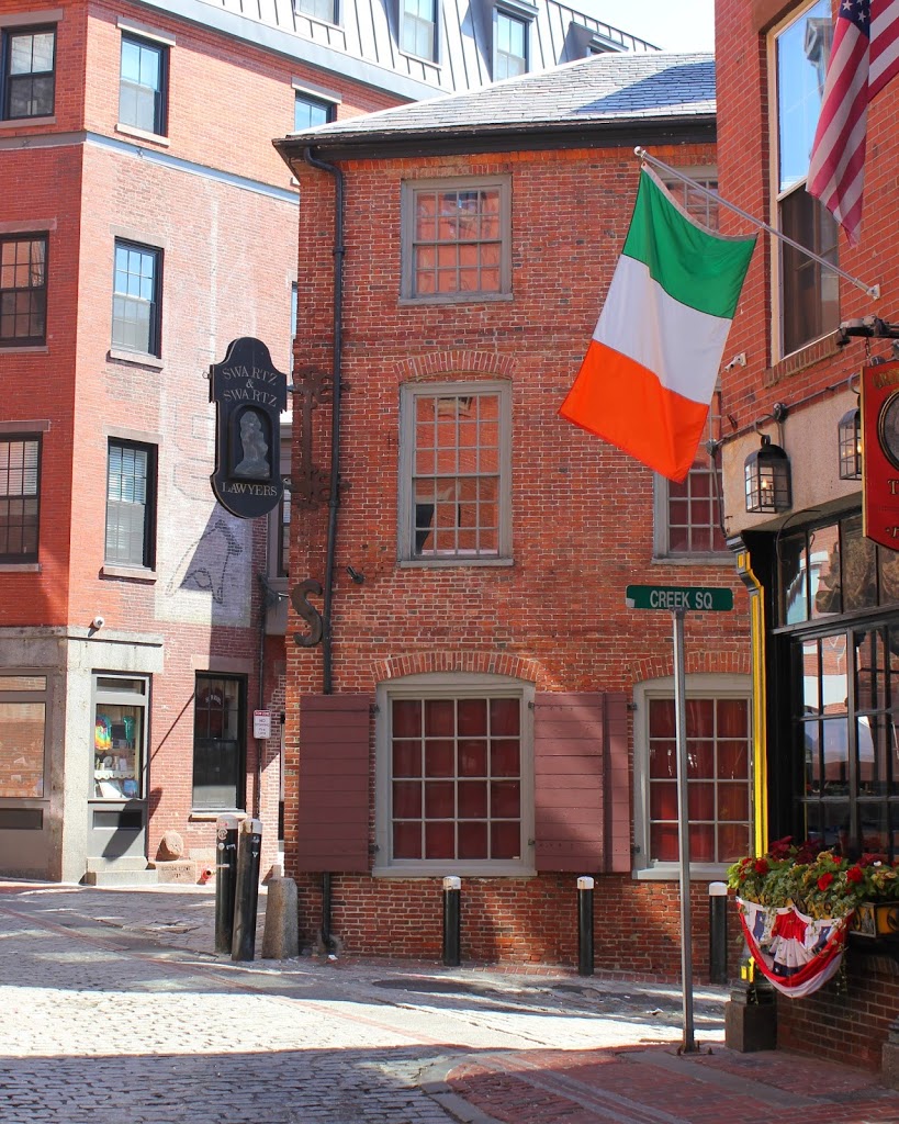
Also of note in this photo is the Boston Stone, seen in the background, embedded in the wall of the building to the left of the Ebenezer Hancock House.  Supposedly, this stone, which actually predates the circa 1835 building, was once used as the zero milestone for Boston, but this doesn’t appear to be likely.  The building, though, is probably the one thing that has changed the most since the first photo was taken.  At some point in the mid 20th century, the building was trimmed down to just three stories.  Today, it has all of its floors again, but this is a recent addition; photos in this post, from the other side of the building, show that the extra stories weren’t there in 2011.

Old Feather Store, Boston

The Old Feather Store at Dock Square in Boston, around 1860. Image courtesy of Boston Public Library.

Colonial

The location in 2014:

268_2014

The building in the 1860 photo looks like it belongs in Elizabethan England, not in 19th century Boston.  However, the building actually dates to the same century as Queen Elizabeth – it was built around 1680, and survived until around the time that this photo was taken.  Despite its age and unique architecture, historical preservation was not a major concern in the 1860s, and it was demolished.  At least one of its contemporaries survives to this day, though.  Just a few blocks up North Street (the road in the foreground of the 2014 photo) is the Paul Revere House, which was built around the same time, and is the only remaining 17th century building in downtown Boston.

As an example of the way Boston has expanded in the past few centuries, the Old Feather Store was built right on the waterfront, but by the time it was taken down, it was over a quarter mile from the harbor.  This area was originally known as Dock Square, because of its proximity to the Town Dock.  As a result, it has long been a center of commercial activity in the city.  Although the buildings that replaced the Old Feather Shop are also long gone, there is one commercial building that is in both photos; Faneuil Hall can be seen behind and to the right of the Old Feather Shop, and on the right-hand side in 2014.

South Station, Boston

South Station around the time that it opened in 1899. Image courtesy of the Library of Congress, Detroit Publishing Company Collection.

263_1899c-loc

The same view around 1905, after the construction of the Atlantic Avenue Elevated. Image courtesy of the Library of Congress, Detroit Publishing Company Collection.

Transportation

South Station in 2014:

These three photos reveal the changes that have taken place here at South Station over the past 115 years.  While the building itself (or at least most of it) has remained essentially the same, its surroundings have continually changed.

Before 1899, four different railroads had terminals in the general vicinity of the present-day station.  To make things simpler, South Station was built, and all four lines were rerouted to it.  A few years later, in 1901, the Atlantic Avenue Elevated was built, as seen in the second photo.  The rapid transit line included a station at South Station, which can be seen on the far right of the 1905 photo.

The third photo shows the result of changes in the way people travel; the Atlantic Avenue Elevated closed in 1938, and was demolished four years later.  Even South Station was seeing a severe drop in passengers in postwar America, as cars became the primary method of travel.  However, Boston’s colonial-era street network was not particularly accommodating to large number of cars, so the Central Artery was built in the 1950s.  Most of the Central Artery was elevated, but it was put underground for a few blocks near South Station, and was known as the Dewey Square Tunnel.

The Dewey Square Tunnel turned out to be a foreshadowing of things to come; part of Boston’s infamous Big Dig involved putting the entire Central Artery underground.  Today, the tunnel is still there, directly underneath where I was standing when I took the photo.  It is the only existing part of the Central Artery; the remainder of the 1950s-era expressway was demolished upon completion of the Big Dig.

Today, South Station has been trimmed a bit – notice that the facade on both sides is shorter than in the first two photos.  This was a result of demolition in the 1960s, at a time when many railroads were cutting back or eliminating passenger service.  However, today South Station is a busy transportation center again – it is the busiest railroad station in New England and the sixth busiest in the country, and it is the northern terminus of the Northeast Corridor, the busiest rail line in the country.

Custom House, Boston

Boston’s Custom House, around 1900-1906. Image courtesy of the Library of Congress, Detroit Publishing Company Collection.

254_1900-1906c-oc.tif

The building in 2014:

254_2014

Although no longer used as a US Customs office, the Custom House still looks much the same as it did when it was completed in 1849, aside from the addition of a 32-story skyscraper on top of it.  When it was built, it was on the waterfront, roughly level with Quincy Market, which was also located along the water.  It was a convenient location, as it facilitated the inspection of ship cargoes.  Today it is several blocks away from Long Wharf, but it continued to be used by Customs for many years.

By the time the first photo was taken, the increase in shipping to Boston necessitated expanding the Custom House, which led to the construction of the Custom House Tower in 1915. At the time, Boston  restricted the height of buildings to 125 feet, but as a federal building it was exempt from these restrictions.  As a result, it was the tallest building in Boston until the completion of the Prudential Tower in 1964.  US Customs left the building in 1986, and it is now a Mariott hotel.