Main Street, Charlemont, Mass

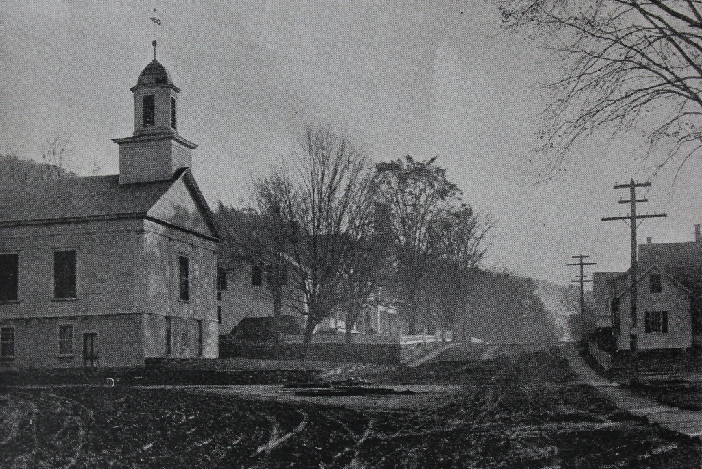
Looking east on Main Street from the corner of North Heath Road in the center of Charlemont, around 1891. Image from Picturesque Franklin (1891).

The scene in 2020:

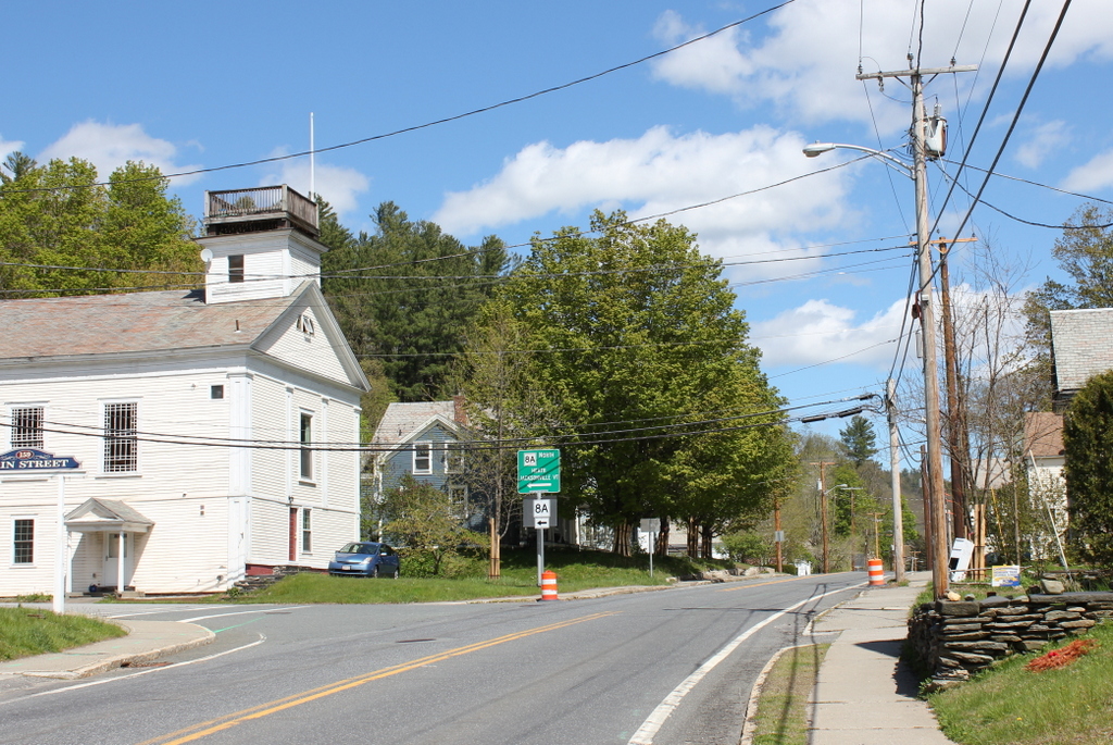
These two photos show the scene looking east on Main Street in the center of Charlemont. The town is situated along the Deerfield River, and this valley serves as the primary east-west route through the northern Berkshires. Charlemont was settled in the mid-1700s, and today the town features a number of historic buildings from the late 18th and early 19th centuries, some of which are visible here in this scene.

On the far left side of the scene is the former Charlemont Methodist Church. The exact origins of this building seem murky, with various sources listing it as having been built in 1840, 1820, or 1770. Regardless of its actual date of construction, it was originally built elsewhere in Charlemont, and it served as the town’s Unitarian church. However, this congregation subsequently disbanded, and in 1861 the Methodists purchased it to replace their own church building, which had been destroyed in a fire. They then moved the former Unitarian building to this site on Main Street. Prior to the move, they built the ground floor to house social rooms, and then placed the church on top of this structure.

Aside from the church, the first photo shows a number of houses on both sides of Main Street. Most feature modest Greek Revival-style designs, and they were likely constructed around the mid-19th century. One of the largest of these houses is the one in the center of the scene, just to the right of the church, which appears to have been enlarged several times during the 19th century. The main section of the house has two stories, and on the left is a one-story ell extending toward the church. There is another one-story addition in the rear of the house, which is connected to a barn.

The 1871 county atlas lists this house as the home of Robert R. Edwards, a local manufacturer who ran a small factory in Charlemont that produced scythe snaths. During the 1870 census, he was 52 years old and living in the town with his wife Lydia, presumably here at this house. At the time, his real estate was valued at $4,000, along with $1,000 for his personal estate, so his total net worth was somewhat higher than that of most of his neighbors. By 1879, his factory employed six workers, and produced a thousand snaths per week. Aside from his business, he served on the board of trustees for the neighboring Methodist Church, and he was also on the town’s library committee. He died in 1910 at the age of 92, so it seems plausible that he was still living here in this house when the first photo was taken.

The first photo depicts the scene here in Charlemont shortly before the dawn of the automobile age. Within just a few years, early “horseless carriages” would begin to make their appearances on the streets. One of the challenges for these pioneering motorists, though, was the generally poor condition of America’s roads. As shown in the first photo, Charlemont’s Main Street was a muddy dirt road, with plenty of ruts left behind by many horse-drawn wagons.

Because of conditions like these, by the early 20th century Massachusetts began upgrading its road network, including the creation of the Mohawk Trail, which was formally designated in 1914. This scenic route, which still exists today as the western part of Massachusetts Route 2, links the northern Connecticut River Valley with the northern Berkshires. Main Street in Charlemont became part of this route, and the town center is the approximate midpoint between Greenfield and North Adams.

Today, notwithstanding the upgrades to the road, this scene has remained well-preserved more than 125 years after the first photo was taken. The center of Charlemont retains much of its historic character, and many of the buildings in the first photo are still standing, including Robert Edwards’s house and the Methodist Church. The church building has undergone significant interior changes, having been converted into a house in the 1960s, but its exterior is mostly the same, aside from the missing belfry. Both the church and the house, along with the other surrounding buildings, are now part of the Charlemont Village Historic District, which was added to the National Register of Historic Places in 1988.

Florida Baptist Church, Florida, Mass

The Florida Baptist Church, seen looking north on Church Road in Florida, around 1893. Image from Picturesque Berkshire (1893).

The scene in 2020:

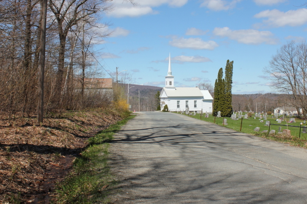
The origins of the name of Florida, Massachusetts are murky, but there seems to have been a certain level of irony to it, since the town has little in common with its southern namesake. Located high in the Hoosac Range of the northern Berkshires, just south of the Vermont state border, Florida has cool weather and high elevations. The town center, shown here, is nearly 1,900 feet above sea level, and the town’s lowest point, located along the Deerfield River, is nearly twice the elevation of the highest point in the state of Florida. Because of this remote, mountainous location, the area was not settled until around 1783, and it was not incorporated as a town until 1805, when it acquired the name of Florida.

In the vast majority of New England towns, incorporation was soon followed by the establishment of a Congregational church. However, here in Florida, the town’s first church was a Baptist church, which was established in 1810 with about 20 members. The first church building was constructed in 1824, and it was used until 1861, when the building here in this scene was completed. The old building was then sold and converted into a house, and it still stands just a little to the north of here, at the present-day corner of Church Road and the Mohawk Trail.

Architecturally, the new building featured a Greek Revival-style exterior, similar to the other small church buildings in the hill towns of western Massachusetts during this period. Writing many decades later in 1907, the North Adams Transcript described how, in the shadow of the impending Civil War, “the whole parish made many sacrifices and literally bared their backs to the burden, considering personal labor, and economy in wearing apparel, thus erecting a new house of worship at the cost of $1,800.” At the time, the church had 51 members, and it had two different pastors who served here in 1861. Rev. J. M. Mace was the pastor for at least part of the year, but he was succeeded by Rev. John Fairman, who served from 1861 to 1865.

Throughout the first half of the 19th century, Florida’s economy was largely agricultural, although the lumber industry was also prosperous here, with at least 14 sawmills in the town by the mid-1850s. However, during the 1860s the town saw a population boom as a result of construction on the Hoosac Tunnel. This 4.75-mile railroad tunnel was built between 1851 and 1873, and most of it, including the eastern portal and the central shaft, is located within the town of Florida. The tunnel runs about a half mile to the north of the church, and about a thousand feet underground. The eastern portal is just under a mile away from here, although the actual travel distance is about 3.5 miles by way of steep, winding mountain roads.

The influx of workers in Florida led to a brief but substantial rise in population, more than doubling in residents from 645 in 1860 to 1,322 in 1870. Much of this growth appears to have been concentrated in the area around the eastern portal along the Deerfield River, so it seems unclear as to what effect this influx had on church membership. Given that many of the workers were Irish, and thus presumably Catholic, it seems unlikely that many would have been interested in making the long uphill climb to attend services at a rural Baptist church.

In any case, the tunnel workers left as quickly as they had arrived, and by the 1880 census the town was down to 459 residents. However, while the town itself experienced a net loss of more than a quarter of its residents between 1860 and 1880, the church saw a substantial increase during this time, growing to 79 members by 1885. During this time, in 1883, the building underwent renovations and repairs, including wallpaper, paint for the pews, and repairs to the chimney. The total cost for the project was about $400. Just after it was completed, the newly-repaired chimney was struck by lightning, but the damage to the building was minimal, and the repair costs were estimated at under five dollars.

The first photo was taken around a decade after these renovations occurred. It shows the view looking north, with the church in the center and a small cemetery next to it. In the foreground, the road is a muddy, heavily rutted path that is lined by a stone wall on the right side and some sort of drainage ditch on the left. Further in the distance, Spruce Mountain provides a dramatic backdrop to the scene. Its peak, on the left side of the photo, rises more than 2,700 feet above sea level, making it one of the highest mountains in the state.

The church was renovated again in 1907. This work was apparently limited to the interior, and it was done by Daniels & Canfield of North Adams. The dedication ceremony was held on September 15, 1907, and the event included guest speaker James McCullough from Savoy, whose grandfather Nathaniel McCullough had been the pastor of the Florida church in the early 1830s. Rev. Willard E. Waterbury of Springfield delivered the sermon, which was based on Isaiah 52:1—”Awake, awake; put on thy strength, O Zion; put on thy beautiful garments.”

Today, more than 125 years after the first photo was taken, parts of this scene have undergone significant changes. Perhaps the most ominous sign of the passage of time is the much-enlarged cemetery next to the church. Other changes include the old Florida Town Hall, which was built in 1923 across the street. The road itself has gone from a muddy dirt path to a paved road, but the most significant transportation change to this scene is the Mohawk Trail, which opened in the early 20th century. The Mohawk Trail made it easy for cars to pass over the Hoosac Range, and over the years it has served as a popular route for scenic road trips.

Throughout this time, the Florida Baptist Church has remained a distinctive landmark for travelers as they approach the road’s high point at Whitcomb Summit. Its exterior appearance has changed somewhat over the years, including a 1980 renovation that involved alterations to the front entryway an addition to the rear, but overall it survives as a good example of a mid-19th century rural New England church.

First Congregational Church, Fall River, Mass

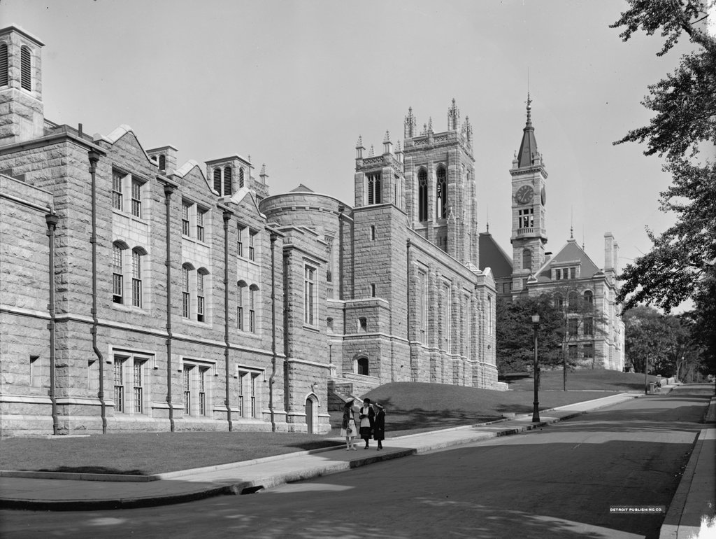
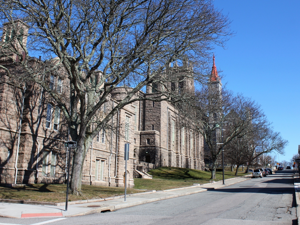
The First Congregational Church, seen looking up Cherry Street from the corner of June Street, around 1913-1920. Image courtesy of the Library of Congress, Detroit Publishing Company Collection.

The church in 2020:

The First Congregational Church of Fall River was established in 1816, and throughout most of the 19th century the church worshipped in a building at the northwest corner of North Main and Elm Streets. However, in 1913 the church moved into this new building, which was donated by one of its parishioners, Sarah S. Brayton. The building was designed by the prominent Boston architectural firm of Shepley, Rutan & Coolidge, and it features a granite, Gothic Revival exterior. It was formally dedicated on January 9, 1913, on the 97th anniversary of the church’s founding. Among those in attendance was Sarah Brayton, who was 78 years old at the time, and the dedication sermon was delivered by the Rev. Nehemiah Boynton of the Clinton Avenue Congregational Church in Brooklyn.

The first photo was taken within a few years after the building was completed. It is a rather strange angle, because it shows the rear and side of the church, with the parish house in the foreground on the left. Further up in the distance, on the other side of Rock Street, is the B.M.C. Durfee High School, which was built in 1886. The three girls on the sidewalk are likely students at the school, and are apparently walking home at the end of the school day. During the early 20th century, the Durfee High School ended at 1:25 p.m., and the photo was taken ten minutes later at 1:35, according to the school’s clock tower.

Today, more than a century after the first photo was taken, almost nothing has changed in this scene except for the trees, which now partially hide the buildings. The church is still an active congregation, and the exterior of the building has remained well-preserved. Further up the hill, the old high school building was converted into a family and probate courthouse in the 1990s, but it has retained its historic exterior appearance. The high school building was added to the National Register of Historic Places in 1981, and two years later both it and the church were designated as contributing properties in the Highlands Historic District.

Free Quaker Meetinghouse, Philadelphia, Pennsylvania

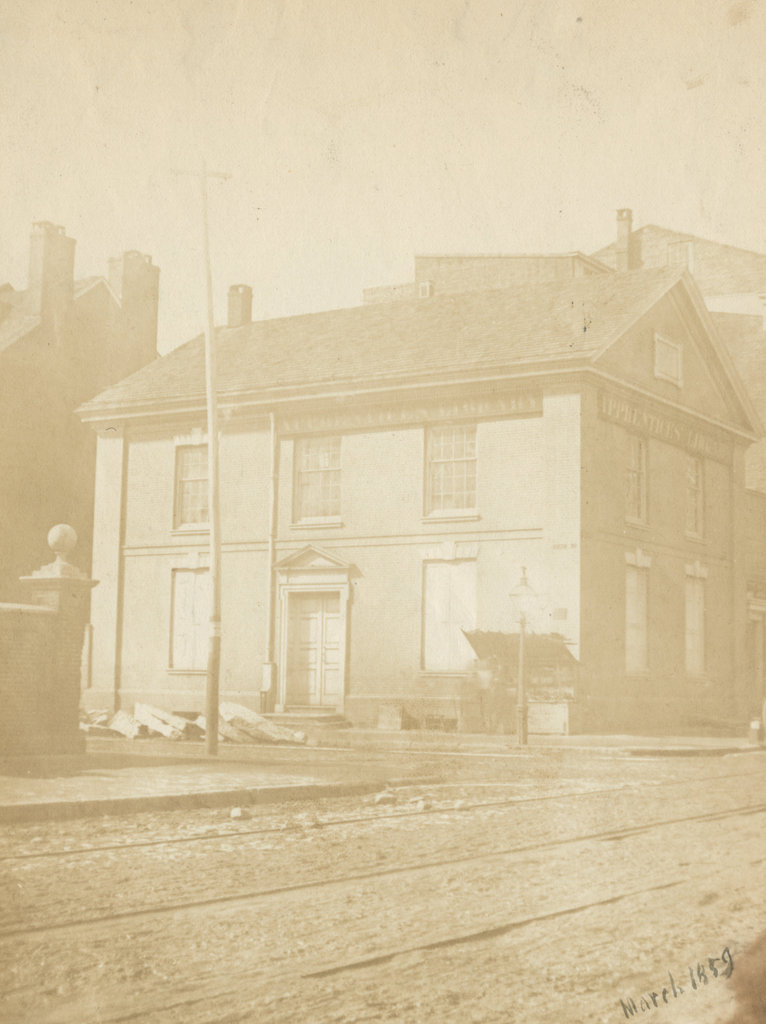
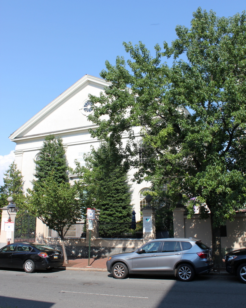
The Free Quaker Meetinghouse at the corner of Fifth and Arch Streets in Philadelphia, in March 1859. Image courtesy of the Library Company of Philadelphia, Frederick De Bourg Richards Photograph Collection.

The scene in 2019:

Philadelphia was the national capital throughout most of the American Revolution, with the city serving as the meeting place of the Continental Congress. However, it also had a large population of Quakers, whose religious beliefs included a strong emphasis on pacifism. This caused significant tension between the colonial leaders here who favored independence, and the Quakers who opposed fighting the war. Far from simply refusing to serve in the military, many Quakers refused to pay taxes that would fund the military, and some even refused to use the currency issued by the Continental Congress, believing that the currency was also being used to pay for the war.

Even within the Quaker community, though, there was significant dissent regarding the war for independence. Here in Philadelphia, some were ultimately expelled for supporting the Revolution, and in 1781 they formed the Religious Society of Free Quakers. The group collected money to purchase a lot and build a meeting house, and among the contributors were George Washington and Benjamin Franklin. The design and construction of the building was largely done by Samuel Wetherill and Timothy Matlack, who were among the leaders of the Free Quakers. Matlack had been a delegate to the Continental Congress during the Revolution, but he is probably best remembered for his penmanship; he hand-wrote the official engrossed copy of the Declaration of Independence in 1776.

The meeting house was completed in 1783, and the occasion was commemorated by a marble tablet under the gable on the Arch Street side of the building, which reads “By general subscription for the Free Quakers, erected in the Year of our Lord, 1783, of the Empire 8.” The last part of the inscription refers to the fact that it was the eight year of the American “empire,” with 1776 as its starting point. At the time, the term empire was a bit of an overstatement for a loosely-affiliated group of 13 states on the east coast, but it ultimately foreshadowed the country’s future expansion across the continent.

Aside from Matlack, several other notable Philadelphians were involved with the Free Quakers, including Betsy Ross, the heroine of the famous but likely apocryphal story about the first American flag. Another likely attendee was Dolley Payne, whose father appears to have joined the Free Quakers after being expelled from the Pine Street Meeting. However, Dolley herself was later expelled from the faith when, in 1794, she married a non-Quaker: future president James Madison.

The Free Quakers steadily dwindled in number during the early 19th century, as the original members either died or moved elsewhere. During this time, though, the building was used for a number of other purposes aside from religious gatherings. From 1788 to 1791, part of the building was the home of John Poor’s Academy for Young Ladies, and from 1791 to 1799 it was occupied by the Grand Lodge of Pennsylvania. Then, from 1800 to 1836 it housed the Philadelphia Select Academy.

In the meantime, the Free Quakers continued to use the meeting house until the late 1830, and after this it was used purely for secular purposes. The next long-term occupant was the Apprentices’ Library Company, which moved into the building in 1841. The library made some changes to the building, including two additions in the 1850s and 1860s, and the organization remained here until 1897. The first photo was taken during this time, in 1859, and the photo shows signs for the Apprentices’ Library on both sides of the building.

Today, more than 160 years after the first photo was taken, and nearly 240 years after the building opened, the Free Quaker Meeting House still stands here as an important landmark at the corner of Arch and Fifth Streets. All of the other historic buildings nearby were demolished in the mid-20th century in order to create the Independence Mall, but the meeting house survived, likely because of its connection to Revolutionary-era Philadelphia. However, the building was relocated in 1961, in order to accommodate the widening of Fifth Street. It was moved 33 feet west and 8 feet south to its current location, and this project also included removing the 19th century additions and subsequently restoring the building to its 1780s appearance.

Saint Paul’s Episcopal Church, Philadelphia, Pennsylvania

Saint Paul’s Episcopal Church, on the east side of Third Street just south of Walnut Street in Philadelphia, in April 1859. Image courtesy of the Library Company of Philadelphia, Frederick De Bourg Richards Photograph Collection.

The church in 2019:

St. Paul’s Church was established in 1760 by a group of parishioners from Christ Church, the city’s oldest Anglican church. They separated from Christ Church because of a controversy surrounding William McClenachan, a former Presbyterian minister who was associated with the evangelical beliefs of the Great Awakening. Some of the leaders within the church, along with the bishop of London, had blocked McClenachan from receiving a position at Christ Church, apparently because of concerns about his past affiliations and support among local Presbyterians. His followers responded by leaving and forming St. Paul’s Church, with McClenachan as their minister. They met for the first time at Independence Hall on June 22, 1760, and they soon began work on their own church building, which would be located here on Third Street.

To help fund the construction costs, the church organized a lottery. This was a common way of raising money during this time, both for public and private projects, and the church hoped to raise 3,000 pieces of eight through the lottery. An advertisement for the lottery appeared in the January 29, 1761 issue of Benjamin Franklin’s Pennsylvania Gazette, with the following description:

As a new Church, called PAUL’s – CHURCH, has been thought necessary, for the Worship of ALMIGHTY GOD, to be erected in this City, by many well disposed Christians; who have, according to their Abilities, chearfully subscribed, and many of them paid considerable Sums of Money, towards carrying on this pious Work. In Consequence whereof, a very large and commodious Building hath been begun, and carried on to the full Height of the Brick Work: But it being judged that the Expence of completing and finishing this Church, will greatly exceed the Sums subscribed; therefore it is thought expedient to set up a LOTTERY, for the raising 3000 Pieces of Eight, which it is hoped will compleatly finish the said Church; and not doubted but all well Wishers to the true Worship of GOD, will favour and encourage this Undertaking.

A total of 5,000 tickets were to be issued, at four dollars each, and the advertisement promised that “This Scheme is the most favourable one heretofore calculated in this City to the Adventurers, the Blanks and Prizes being considerably less than two to one.” There were many tiers of prizes, ranging from 1,515 tickets that would win 8 pieces of eight each, to a single grand prize of 1,000 pieces of eight.

The church was ultimately completed later in the year, and the first services were held here on December 20, 1761. Reverend McClenachan was still the rector at the time, although he would only remain in the position for a few more years; he retired in 1765 and moved to Maryland, where he died a year later. His departure, however, may have helped to resolve the conflict between St. Paul’s and Christ Church, because in 1773 his successor, William Stringer, was ordained by the bishop of London.

Within a few years, though, Reverend Stringer himself would be a source of controversy within the church. During the American Revolution, Stringer remained loyal to the British crown, despite many parishioners with patriot sympathies. The division culminated in the fall of 1777, after the British army captured Philadelphia. On the next Sunday after the capture, Stringer preached from Ezekiel 20, which speaks of the rebelliousness of Israel, including a verse that was particularly incendiary given the context of the war: “And I will purge out from among you the rebels, and them that transgress against me.” Many of the church members interpreted this scripture selection as a thinly-veiled threat, and this sermon marked the end of Stringer’s tenure as rector; he soon left the church and returned to England.

During the 19th century, St. Paul’s had several rectors who achieved national prominence. Among these was Stephen H. Tyng, who served here from 1829 to 1833. He was a leader in the evangelical wing of the Episcopal Church, and much of his ministry was focused on providing social services and other outreach programs for the poor. During his time here in Philadelphia, he also focused some of his efforts on changing the physical church building. This included altering the interior to make space for Sunday school programs, along with removing elements that were considered old-fashioned by the 1830s, including the colonial-era high back pews. The project was overseen by prominent Philadelphia architect William Strickland, and the building was re-dedicated on New Year’s Day in 1831.

Aside from Reverend Tyng, the other notable 19th century rector here was R. Heber Newton. His father, Richard Newton, had served here from 1840 to 1862, and the younger Reverend Newton became rector in 1866 at the age of 26. He remained here for just three years, though, before leaving to accept the position of rector at All Souls’ Protestant Episcopal Church in New York City. While in New York, he became a leader in the Social Gospel movement. However, he also faced criticism from other Episcopalian clergy, and in 1883 he was charged with heresy for, among other things, supposedly denying essential doctrines such as the inerrancy of the Bible and the divinity of Jesus. He went on to face similar accusations in subsequent years, but retained his position within the church until 1902.

The first photo, which was taken in 1855, shows the exterior of the church as it appeared during Newton’s father’s time as rector. It would remain an active parish throughout the rest of the century, but in the later years it experienced a decline. This neighborhood, which had once been a fashionable residential area in the 18th and early 19th century, was no longer as desirable, and many of its affluent parishioners had relocated elsewhere in the city. Attendance in general dropped, as did church revenue, to the point where it could no longer support itself. As a result, in 1901 the church’s leaders requested that it be dissolved, with its property transferred to St. Peter’s Church, which is located just a few blocks south of here.

Despite this closure, the old St. Paul’s building ultimately remained in use by the Episcopal Church. Today, nearly 170 years after the first photo was taken, the building is still standing with few exterior alterations. It is no longer used for religious services, but since 1906 it has been the home of Episcopal Community Services, which offers assistance programs in areas such as food, housing, healthcare, and education. It seems only appropriate that the organization would be housed in this building, since in many ways it fulfills the Social Gospel-related ideals of its former ministers such as Tyng and Newton.

Old Dutch Church, Sleepy Hollow, New York

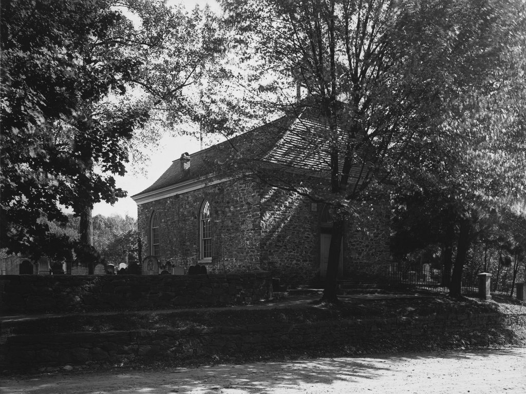
The Old Dutch Church of Sleepy Hollow, around 1903. Image courtesy of the Library of Congress, Detroit Publishing Company Collection.

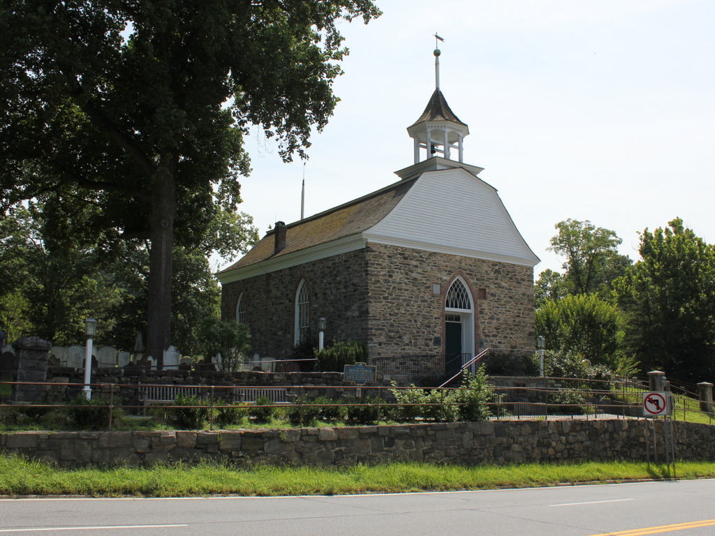
The church in 2019:

This church was made famous by Washington Irving’s 1820 short story “The Legend of Sleepy Hollow,” but the building predates the story by more than a century, and it stands as the second-oldest existing church building in the state of New York. It was built in the late 1690s by Frederick Philipse I, a wealthy Dutch settler who owned a large tract of land along the Hudson River in Westchester County.

Philipse immigrated to New York in the 1650s, about a decade before England gained control of the colony from the Dutch. However, the Dutch landowners here were allowed to retain their property, and by the 1670s he had acquired a significant amount of land, including the modern-day municipalities of Yonkers, Greenburgh, and Mount Pleasant. At the time, there was a small community here in North Tarrytown, including a graveyard here on the left side of this scene. However, the people lacked a permanent church building, so in the late 1690s Philipse had this stone, Dutch Colonial-style church constructed at the southern end of the graveyard for his tenant farmers. By some accounts, Philipse designed the church himself, and he also may have personally assisted with the construction work, including carving the pulpit.

The church is located on the west side of the Albany Post Road, modern-day US Route 9, on a hillside about a hundred yards north of where the road crosses the Pocantico River. During the American Revolution, this area around Sleepy Hollow was a sort of neutral zone, located between British-occupied New York City and the areas to the north, which were controlled by the Continental Army.

One of the most important wartime incidents here occurred in 1780, when Major John André was captured by American forces less than a mile south of the church. He had been returning south after a secret meeting with Benedict Arnold, and upon searching him the Americans discovered documents that incriminated Arnold in a plot to surrender West Point to the British. Arnold was able to evade capture after the plot was exposed, but West Point remained secure and André was subsequently executed as a spy, since he had been behind enemy lines in civilian clothing.

Another significant local event in the war was the Battle of White Plains, which was fought a few miles to the southeast of here in 1776. During the battle, a Hessian soldier was decapitated by an American cannonball, and this is said to have been the inspiration for the Headless Horseman of “The Legend of Sleepy Hollow.” In the story, the narrator describes how, according to legend, the ghostly apparition had lost his head in “some nameless battle” during the war. He was buried here in the graveyard next to this church in Sleepy Hollow, but he would leave every night and travel to the battlefield in search of his head, although he always needed to return to the graveyard by dawn.

By the time Washington Irving published his story in 1820, this church was already over 120 years old. In the story, he emphasized the eerie, isolated location of the church, particularly in this passage:

The sequestered situation of this church seems always to have made it a favorite haunt of troubled spirits. It stands on a knoll, surrounded by locust-trees and lofty elms, from among which its decent, whitewashed walls shine modestly forth, like Christian purity beaming through the shades of retirement. A gentle slope descends from it to a silver sheet of water, bordered by high trees, between which, peeps may be caught at the blue hills of the Hudson. To look upon its grass-grown yard, where the sunbeams seem to sleep so quietly, one would think that there at least the dead might rest in peace. On one side of the church extends a wide woody dell, along which raves a large brook among broken rocks and trunks of fallen trees.

The first photo shows the church as it appeared nearly a century later, around 1903. By this point, both the church and its surroundings had undergone changes. The church was damaged by a fire after a lightning strike in 1837, and the repairs included alterations to the building. It was partially restored to its original appearance in the late 19th century, but by then it was no longer in regular use. The congregation had moved to a new building in Tarrytown during the mid-19th century, and the old one here in Sleepy Hollow was subsequently used only for special events.

Also during this period, the land around the church became a new cemetery. Originally named the Tarrytown Cemetery, it was later renamed Sleepy Hollow Cemetery at the request of Washington Irving, who was interred here after his death in 1859. Unlike the much older graveyard next to the church, this new cemetery reflected the mid-19th century trend of rural cemeteries. These were typically well-landscaped, with plenty of trees and winding footpaths that followed the contours of the ground, making cemeteries feel more like a park. Aside from Irving, many other prominent people have been buried here in Sleepy Hollow, including industrialist Andrew Carnegie after his death in 1919.

Today, more than a century after the first photo was taken, the 320-year-old church is still standing here alongside US Route 9. Remarkably little has changed in the scene during this time, and the building is still owned by the Reformed Church of the Tarrytowns, which continues to hold events and services here on occasion. Because of its historical significance, along with its literary associations with “The Legend of Sleepy Hollow,” the church was designated as a National Historic Landmark in 1961.