Union and North Water Streets, New Bedford, Massachusetts

The northwest corner of Union and North Water Streets in New Bedford, in November 1893. Image courtesy of the New Bedford Free Public Library, Gilbert D. Kingman Photograph Collection.

The scene in 2022:

These two photos show the northwest corner of Union and Water Streets in downtown New Bedford. The most prominent building in the scene, and the only one that appears in both photos, is the three-story brick building here in the foreground at the corner. It was built around 1820, and it is known as the Sundial Building because of the vertical sundial between the second story windows on the left side. To the left of it in the first photo are several other early 19th century buildings, including the Macomber-Sylvia House, which was built in 1816 and later embellished with Italianate-style details.

During the 19th century, the Sundial Building had a variety of different commercial tenants. In the 1840s these included the merchant tailor firm of C. Ricketson & Son and the grocer Edward Bourne. By the 1850s there was another tailor here, C. W. Chapman & Co., followed by hair dresser A. G. Jourdain in the 1860s. Then, in the 1870s the building became a restaurant, with Steven’s Dining Rooms occupying two floors here. The first photo was taken in 1893, but by this point it does not appear to have had any commercial tenants on the ground floor, as evidenced by the shuttered windows on the right side and the lack of signage above any of the storefronts.

Overall, the buildings here in this scene would remain largely unchanged until January 18, 1977, when a gas explosion caused considerable damage here at this intersection. The explosion was caused by a leaking gas pipe in the basement of O’Malley’s Tavern, which occupied the building just to the left of the Sundial Building. That building was completely destroyed, as was the Macomber-Sylvia House to the left of it, which had just finished undergoing a major restoration. As for the Sundial Building, it was gutted by the subsequent fire and was nearly demolished, but it was ultimately saved and restored to its original appearance. The building  is now part of the New Bedford Whaling Museum, which occupies most of the block between North Water Street and Johnny Cake Hill.

Bradley Street, New London, Connecticut

The view looking north on Bradley Street from the corner of State Street in New London, around 1868. Image courtesy of the New York Public Library.
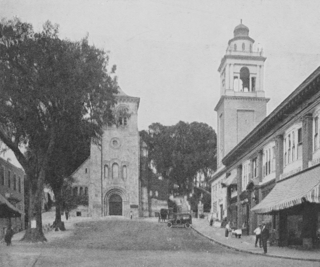
The scene in 2021:

During the 1800s, New London was an important seaport, in particular because of its role in the whaling industry. At one point, it was second only to New Bedford in terms of number of whaling ships, which brought significant prosperity to the city. However, like other major ports, New London also had its share of crime, poverty, and vice, and perhaps no street in the city better exemplified this than Bradley Street, which is shown in the first photo around 1868.

At the time, Bradley Street began here at State Street, and it ran northward parallel to Main Street for three blocks, before ending at Federal Street. The northern end of the street was predominantly residential, but the southern end, shown here in this scene, had an assortment of commercial buildings, mostly older wood-frame structures.

There are a few signs that are visible in the first photo, advertising for businesses such as a harness maker at the corner of State Street and a bakery further down Bradley Street. However, the street was better known for its less reputable establishments, particularly its saloons and brothels. As early as the 1840s, women were convicted for running “houses of ill fame” here on Bradley Street, and the street would remain the epicenter of the city’s red light district into the early 20th century. Even Eugene O’Neill, the prominent playwright, would patronize these brothels as a young man while spending summers with his family in New London, and he made reference to one of the madams, “Mamie Burns,” in his famous play Long Day’s Journey into Night.

By the turn of the 20th century, when O’Neill would have made his visits to Bradley Street, the street was predominantly the home of working class immigrants, particularly Polish and Jewish families. However, the relatively short street also had up to 13 saloons and four brothels in operation by 1910, as outlined by Dr. Matthew Berger in a 2021 blog post.

In an effort to overcome the street’s seedy reputation, it was eventually rebranded as North Bank Street around 1921. Then, around the 1960s it became Atlantic Street, and it was about this same time that all of the older buildings on the street were demolished as part of an urban renewal project. The street was also truncated so that it now ends after just one block, rather than continuing all the way to Federal Street. The result is a streetscape that looks more or less like every other urban renewal project of the 1960s, with a parking garage on one side and a vaguely brutalist office building on the other side.

However, there is one historic building that stands in the present-day scene. On the far right side in the foreground is the Nathan Hale Schoolhouse. It was built in 1773, and the famous Revolutionary War hero taught here from 1774 to 1775. This is not its original location, though. It has been moved six times over the past 250 years, most recently in 2009 when it was brought to its current location at the corner of what had once been Bradley Street.

Ocean Bank, Stonington, Connecticut

The First National Bank building, formerly the Ocean Bank, on the north side of Cannon Square in Stonington, in November 1940. Photo by Jack Delano, courtesy of the Library of Congress, FSA/OWI Collection.

The scene in 2021:

The first photo was taken in November 1940 by Jack Delano, a noted photographer who was employed by the Farm Security Administration in the late 1930s and early 1940s. In this capacity, he was part of a team of photographers who traveled around the country, documenting life in America during the Great Depression. He was in Connecticut during the fall of 1940, where he visited a number of cities and towns, including here in Stonington. His caption for this photo is simply, “A bank for sale in Stonington, Connecticut,” and he perhaps chose this subject as a way of representing the effects of the Depression on the once-prosperous whaling and fishing port.

Nearly a century before its demise in the Great Depression, the First National Bank of Stonington had its origins in 1851, with the incorporation of the Ocean Bank. This small Greek Revival bank building was constructed around this time, and the bank’s first president was Charles P. Williams, a former whaling ship captain. Williams had gained considerable wealth in the whaling industry, and he went on to further expand his fortune through real estate speculation. By the time he died in 1879, he was said to have been the wealthiest man in eastern Connecticut, with an estate valued at around $3 million.

In the meantime, the Ocean Bank became the First National Bank of Stonington in 1865, and it would remain in business here in this building for the next 75 years. However, the bank ultimately closed in February 1940, leaving the town of Stonington without any financial institutions. The bank’s president at the time, Judge J. Rodney Smith, explained in newspaper accounts that, although the bank itself was financially sound, the business conditions in town made the bank unprofitable for investors. He apparently did not cite specific reasons for this, but a likely cause was the ongoing Great Depression, along with the recent hurricane in September 1938, which battered coastal Connecticut.

As the sign in the first photo shows, the bank building was still for sale when Jack Delano took the photo some nine months after the bank closed. The building would ultimately be acquired by the Stonington Historical Society in 1942. The organization originally intended to turn the building into a museum and headquarters, but over the years it has instead been used as a rental property. Today, the historical society still owns the building, which has remained well-preserved in its 19th century appearance. It has also retained its original use as a bank, and it is currently a branch of Dime Bank, as shown on the sign on the left side in the 2021 photo.

Philadelphia Arcade, Philadelphia, Pennsylvania

The Arcade Hotel on the north side of Chestnut Street, between Sixth and Seventh Streets in Philadelphia, in January 1858. Image courtesy of the Library Company of Philadelphia, Frederick De Bourg Richards Collection.

The scene in 2019:

In 1819, the Burlington Arcade opened in London, becoming one of the earliest precursors to the modern shopping mall. It soon inspired similar buildings here in the United States, including ones in New York, Providence, and here in Philadelphia. The Philadelphia Arcade, shown here in the first photo, was designed by John Haviland, an architect who was responsible for many important buildings in early 19th century Philadelphia. Work on the building began in 1826, and it was completed a year later, at a cost of $112,000.

In the architectural sense, an arcade is a series of arches, and this building featured four large arches here on the Chestnut Street façade. The Arcade extended the width of the block to Carpenter Street (modern-day Ranstead Street), and on the interior it featured three floors The first two floors each had two parallel hallways, or “avenues,” that were topped by skylights, and these avenues were lined by shops and offices on either side. On the third floor was the Philadelphia Museum, which had been established by prominent artist Charles Willson Peale. In total, the Arcade could house 80 shops and professional offices, and it also had a restaurant in the basement.

The intent was that this section of Chestnut Street would become the commercial center of the city, with the Arcade as an upscale shopping center that would attract high-end tenants and affluent customers. From the beginning, however, the Arcade struggled to fill vacant spaces in the building, and an 1829 report lists just 33 tenants here. In general, the ground floor primarily housed retail shops, selling goods such as books, boots and shoes, clothing, confectioneries, dry goods, lamps, and tobacco. The second floor also featured several stores, but it was primarily office space, with tenants such as lawyers, editors, employment services, an engraver, and a bookkeeping teacher. Overall, these businesses here in this building offered customers a variety of goods and services, but these were hardly the exclusive boutique shops that the Arcade’s founders had envisioned.

The decline of the Arcade continued over the next few decades, especially after the Philadelphia Museum moved to a new location. The building was eventually purchased by Dr. David Jayne, who converted the upper floors into the Arcade Hotel. It opened in 1853, and it provided accommodations for men only, at a rate of 50 cents per night. Guests could also eat here at the hotel, for 25 cents per meal for breakfast or supper, or 50 cents for dinner. The Arcade Hotel had nearly 200 guest rooms, and it also featured a saloon, a reading room, and a smoking room, in addition to the dining room. The saloon was located here at the front of the building, with a balcony that was likely added during the hotel renovations.

The first photo was taken a few years later, showing the Chestnut Street façade of the building. It was still in use as a hotel at this point, with storefronts on the ground floor, but it would only stand here for a few more years. In 1863, it was demolished and replaced by three new commercial buildings. These buildings, in turn, have long since been demolished, and most of this block is now One Independence Mall, a high-rise office building that has a parking garage here on the lower floors.

Fifth and Minor Streets, Philadelphia, Pennsylvania

Looking north on Fifth Street near the corner of Minor Street in Philadelphia, in February 1859. Image courtesy of the Library Company of Philadelphia, Frederick De Bourg Richards Collection.

The scene in 2019:

The first photo shows a row of commercial buildings along the west side of Fifth Street. Of these, the most significant is Robert Smith’s Brewery in the center of the scene. This brewery underwent many name changes over its long history, but it dated back to the colonial era, when Joseph Potts opened a brewery here around 1774. Potts operated it until 1786, when he sold it to Henry Pepper. By this point Philadelphia had become a leading producer of beer, and this brewery remained in the Pepper family for many years. Robert Smith, a native of England who had learned the trade as an apprentice at the Bass Brewery, joined the firm in 1837, and eventually took over the business in the following decade.

As was the case in most early American breweries, this facility produced ale. Americans began to acquire a taste for lagers by the second half of the 19th century, thanks to an influx of German immigrants with surnames like Busch, Coors, Miller, and Pabst. Here in Philadelphia, though, Robert Smith continued to have success brewing ales. He remained here for nearly 30 years after the first photo was taken, and eventually incorporated the business as the Robert Smith India Pale Ale Brewing Company in 1887. A year later, he moved to a new, larger facility at the corner of 38th Street and Girard Avenue. Smith ran the brewery at the new location until his death in 1893.

Smith’s brewery business was ultimately acquired by the Christian Schmidt Brewing Company, the largest brewery in the city. With the exception of the Prohibition era, Schmidt continued brewing Smith’s popular Tiger Head Ale until the company closed in 1987. In the meantime, the original brewery here on Fifth Street was likely demolished soon after Robert Smith moved to the new brewery, and it was definitely gone by the mid-1950s, when this entire block was demolished to make way for the Independence Mall. As a result, there are no surviving buildings from the first photo, and even Minor Street itself is gone. This site is now the southeastern section of the Independence Mall, and it is located only a few hundred feet to the north of Independence Hall.

Jayne Building, Philadelphia, Pennsylvania

Looking west on Chestnut Street between Bank and Third Streets in Philadelphia, around 1859. Image courtesy of the Library Company of Philadelphia, Frederick De Bourg Richards Photograph Collection.

The scene in 2019:

The first photo shows the view looking west along the south side of Chestnut Street, from near the corner of Bank Street. The scene features a variety of commercial buildings, but the most prominent of these is the Jayne Building in the center of the photo. Built between 1849 and 1851, this eight-story building was far ahead of its time, predating the advent of modern skyscrapers by nearly half a century. As such, it is generally considered to be the first skyscraper in the city, and arguably the first in the entire country as well.

The Jayne Building was designed by local architect William L. Johnston, and it featured a Gothic Revival exterior of Quincy granite. In contrast to most of the neighboring buildings, its façade featured strong vertical lines that emphasized its height, a technique that would later become common for 20th century skyscrapers. However, the building also featured a two-story crenelated tower atop the roof, giving it an unusual combination of modern and medieval-style architecture.

The building was owned by Dr. David Jayne, a physician who made his fortune selling patent medicines. Although based in Philadelphia, he sold his products across the country. He even published a free almanac that was replete with medical advice, most of which involved taking one or more of his products. Among these were the Expectorant, which was intended for lung diseases, and the Alterative, which Jayne claimed could treat a wide range of ailments, including cancer, gout, rheumatism, scrofula, scurvy, syphilis, ulcers, and various skin disorders.

Architect William L. Johnston provided much of the vision for Jayne’s building, but he did not live to see it completed. He died of tuberculosis during the early stages of the construction, and another Philadelphia architect, Thomas Ustick Walter, oversaw the rest of the work. Walter also designed two six-story wings, one on either side of the main building, which were completed in 1851 and are visible here in the first photo. Also in 1851, Walter was appointed as Architect of the Capitol, and in this capacity he designed both the House and Senate wings of the US Capitol, along with the current Capitol dome.

David Jayne died in 1866 at the age of 66, but his family carried on the business for many years. However, just six years later this building was gutted by a massive fire on the night of March 4, 1872. The fire started around 9:00 p.m. in the rear of the third floor, but it soon spread up to the top of the building. Firefighting efforts were hampered by the height of the building, and also by the sub-zero temperatures, which caused the water to freeze into icicles on the exterior. However, firefighters succeeded in preventing the flames from spreading to the six-story wings, and most of the exterior walls remained standing, despite extensive damage to the interior.

The building was subsequently reconstructed around the old walls, albeit without the ornate two-story tower atop the roof. It would remain here for the next 80 years, but by the mid-20th century it was threatened by an urban renewal project related to the Independence National Historical Park. Planners envisioned a park area that would feature the city’s prominent Revolutionary-era landmarks surrounded by open space, rather than being crowded by more recent development. This meant the demolition of many 19th century buildings that, despite their architectural and historic significance, were not a part of the park’s mission.

In the case of the Jayne Building, it stood on the periphery of the park, three blocks away from Independence Hall. The mid-19th century proto-skyscraper clearly had no connection to the American Revolution, but some preservationists made an effort to have the building spared. Among these was Charles E. Peterson, who in 1951 published a theory that the Jayne Building had likely helped to influence the design of more modern skyscrapers, since prominent architect Louis Sullivan had once worked out of an office across the street from here. However, this appeal failed to convince the park planners to save the building, and it was ultimately demolished in the fall of 1957.

Today, more than 160 years after the first photo was taken, there are no surviving landmarks from the first photo. Many of the older commercial buildings were likely replaced by newer buildings later in the 19th century, but anything that was still standing by the 1950s would have, like the Jayne Building, been demolished as part of the Independence National Historical Park. Here in the foreground, where the Jayne Building once stood, this site became a visitors center. This building was, in turn, demolished in 2014, and the site is currently occupied by the Museum of the American Revolution, which is shown here in the 2019 photo.