High Street from Lyman Street, Holyoke, Mass

Looking south on High Street from Lyman Street in Holyoke, around 1892. Image from Picturesque Hampden (1892).

The scene in 2017:

This scene shows the same block of High Street as this previous post, just from the opposite direction. As mentioned in that post, these buildings were mostly built around the 1860s and 1870s, with the oldest probably being the Fuller Block in the center of the photo, which dates back to around the 1850s. Closer in the foreground, there are seven very similar Italianate-style brick commercial blocks. The six closest to the camera were all built around the same time, probably about 1870, and the one near the center of the photo was built a little later, around 1878. Holyoke’s Gothic-style city hall also dates back to around this time, having been completed in 1876, and its tower rises in the distance of both photos.

Today, this scene has not significantly changed in the past 125 years. Everything on High Street to the north of Lyman Street was demolished in the 1970s as part of an urban renewal project, but most of the historic High Street buildings are still standing to the south of Lyman Street. The Fuller Block is still here, as are most of the other buildings beyond it, and five of the seven buildings in the foreground are also still standing. The building on the far left, at the corner of Lyman Street, is gone, as is the one at the corner of Oliver Street, but otherwise this scene retains much of its late 19th century appearance. Because of this, the buildings along this section of High Street are now part of the North High Street Historic District, which was added to the National Register of Historic Places in 1986.

High Street from Oliver Street, Holyoke, Mass

Looking north on High Street from near Oliver Street in Holyoke, around 1892. Image from Picturesque Hampden (1892).

The scene in 2017:

As mentioned in the previous post, this section of High Street was developed in the second half of the 19th century as one of the primary commercial centers in Holyoke. Most of the buildings in this scene date to around the 1860s and 1870s, but perhaps the oldest is the Fuller Building, visible on the far right of the scene at the corner of Oliver Street. It was built sometime before 1863, probably around the early 1850s, and is a rare example of Greek Revival architecture in a city that is largely dominated by Italianate-style commercial blocks.

Just beyond the Fuller Building, on the other side of Oliver Street, is the four-story Hutchins House, which was built in 1878. Around the time that the first photo was taken, it was being used as a boarding house, with several stores on the ground floor, including a dress and cloak maker as well as a dry goods store. Just beyond this building is a row of five matching Italianate-style blocks, all of which were built sometime around 1870. The Hutchins House has since been demolished, and the site is now a small parking lot, but the other five buildings are all still standing with few exterior changes since the first photo was taken.

Likewise, the buildings on the left side of the photo also date back to around the 1860s and 1870s, and most of the ones in the foreground still survive, although the one on the far left of the first photo appears to have either been demolished or trimmed down to one story. Otherwise, the only significant change in this scene is further in the distance, beyond Lyman Street. Originally, High Street continued north for two more blocks beyond Lyman Street, ending at the present-day Pulaski Park, but these buildings were demolished in the 1970s as part of an urban renewal project, and today the Echo Hill Townhouses are located on the site.

High Street from Hampden Street, Holyoke, Mass

Looking north on High Street from the corner of Hampden Street in Holyoke, around 1892. Image from Picturesque Hampden (1892).

The scene in 2017:

Holyoke was developed into a major industrial center starting in the mid-19th century, and a number of factories were built along the city’s network of canals. Around the same time, two commercial districts were developed to serve the needs of the rapidly-growing population, with one along Main Street at Depot Square and the other one here, a few blocks up the hill on High Street. The commercial blocks here on this section of High Street were primarily built between the 1850s and 1870s, and nearly all are brick, typically with four stories. In the 125 years since the first photo was taken, this street scene has remained remarkably well-preserved, with few significant changes since the first photo was taken.

The most visible building in this scene is the W. L. Martin Block, which was built around 1860 at the corner of High and Hampden Streets. Its design is typical of the earlier commercial buildings in Holyoke, with a relatively plain exterior that contrasts with the more ornate styles of later decades. Just beyond it is the two-story Fuller’s Block, which was built in 1857 by John Fuller, a developer whose property included this building as well as the rest of the lots between here and Oliver Street. Around 1870 he built the one-story buildings near the center of the first photo; these are still standing, although hidden from view by trees in the 2017 photo. Fuller also built the large, gable-roofed building at the corner of Oliver Street. It was completed no later than 1863, and probably as early as the 1850s, making it among the oldest surviving commercial buildings in downtown Holyoke.

Today, nearly all of the buildings in the foreground of this scene are still standing. Everything beyond Lyman Street, which is barely visible two blocks in the distance, was demolished in the 1970s as part of an urban renewal project, but south of Lyman Street very little has changed. The only noticeable loss on the right side of the street in this section is the Hutchins House, which is visible in the distance just to the left of the center of the first photo. Demolished sometime in the late 20th century, this building has not been replaced, and there is now a small parking lot on the site. Otherwise, the rest of the buildings are still standing, and these blocks of High Street are now part of the North High Street Historic District, which was added to the National Register of Historic Places in 1986.

Main Street from Dwight Street, Holyoke, Mass

Looking north on Main Street from the corner of Dwight Street in Holyoke, around 1892. Image from Picturesque Hampden (1892).

The scene in 2017:

These two photos, taken 125 years apart, show some of the dramatic changes that the city of Holyoke has experienced in the intervening years. When the first photo was taken, Holyoke was among the world’s leading producers of paper, and at its peak the city had more than two dozen paper mills along its extensive canal system. The resulting influx of factory workers led to a dramatic increase in the city’s population, from under 5,000 in 1860 to over 35,000 in 1890, and the first photo shows a busy Main Street, filled with trolleys, horse-drawn carriages, and pedestrians.

The commercial buildings on the right side of Main Street show a mix of late 19th century architectural styles, and are predominantly brick with three or four stories. Probably the oldest building on the right side of the first photo is the Perkins Block, which dates back to about 1870 and was, in later years, known as the Hotel Jess. Its Italianate design was typical of the era, and it includes cast iron ornamentation that has remained well-preserved over the years. Just beyond it is another, somewhat shorter Italianate building, which was built in the mid-1880s. It lacks the cast iron on the exterior, but it has a similar bracketed cornice at the top of the building. The only other building still standing on the right side of the street from the first photo is the narrow, four-story building in the center, which was built around 1883 and has seen few exterior changes since then.

Otherwise, all of the other buildings on this side of the street have either been replaced by newer ones or are now vacant lots. Perhaps the most notable of these lost buildings is the Whiting Street Building at 32 Main Street, the four-story granite building just to the left of the center of the first photo. Completed in 1885, it was owned by Whiting Street, a prominent landowner for whom the Whiting Street Reservoir is named. By the time the first photo was taken, the building was the home of the recently-established American Pad and Paper Company. Now known as Ampad, this company is still a major producer of writing pads and other paper products, although it has long since relocated its headquarters out of Holyoke.

The only building visible on the left side of the first photo is the Holyoke House, which was later known as the Hotel Hamilton. Built in the early 1850s, it was significantly expanded over the years and is still standing, although it has lost its top floor. Like many of the buildings across the street, it is now abandoned, and today the scene of boarded-up storefronts, vacant lots, and a deserted Main Street contrasts sharply with the photo taken at the same site in the 1890s.

Main and Old South Streets, Northampton, Mass

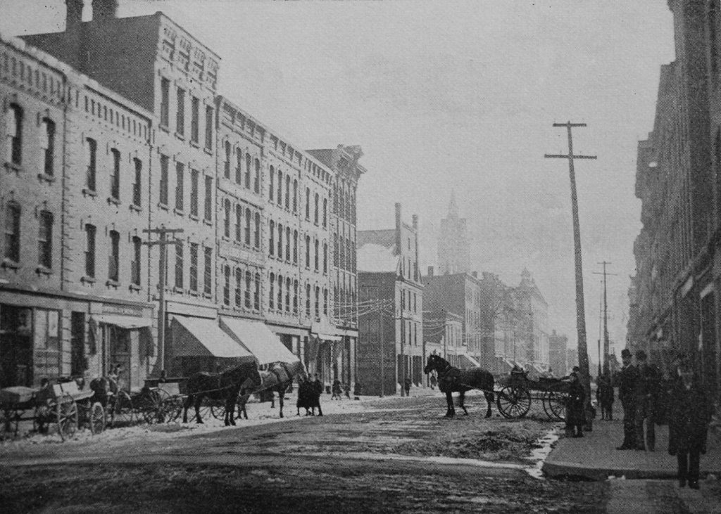
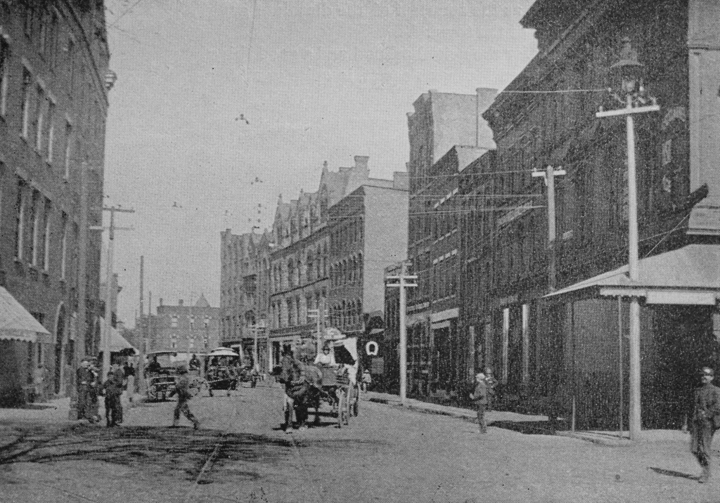
The south side of Main Street, just east of the corner of Old South Street in Northampton, probably sometime in the 1860s. Image from Northampton: The Meadow City (1894).
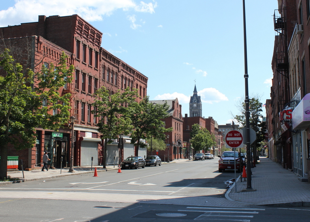
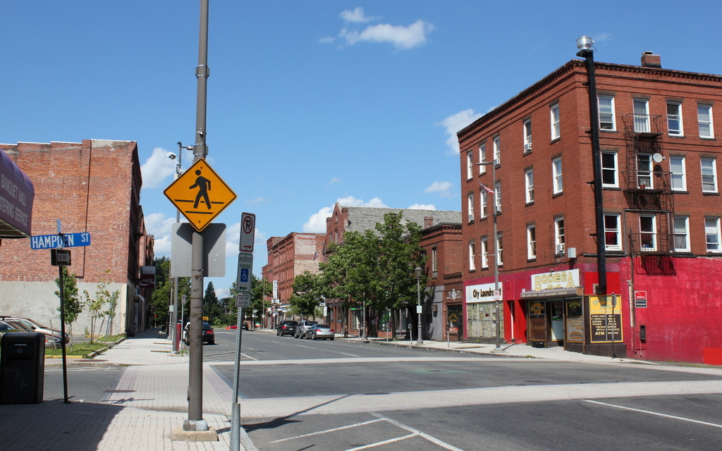
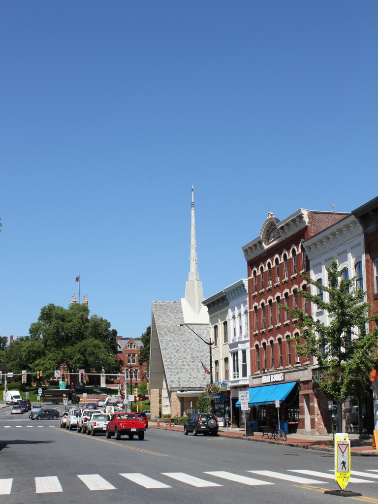
The scene in 2017:

The first photo shows the scene along the south side of Main Street in Northampton, sometime around the 1860s. The four buildings here represent a variety of uses and architectural styles, with two mid-19th century brick commercial blocks on the left, a Georgian-style house in the center, and a Greek Revival-style Edwards Church on the right. The most notable of these buildings was the church, which was built in 1833 at the corner of Main and Old South Streets. Formed as an offshoot of the First Church, it was named in honor of Jonathan Edwards, who had served as pastor of the First Church from 1729 to 1750. The congregation worshipped here in this modest wood-frame church for the next 37 years, until it was destroyed by a fire in 1870.

This same fire also destroyed the adjacent Hunt Building, which was built in 1770 as the home of Dr. Ebenezer Hunt. A 1764 graduate of Harvard, Hunt studied medicine in Springfield under Dr. Charles Pynchon, before returning to his native Northampton in 1768. This house was built two years later, with Georgian-style architecture that was similar the home of his second cousin, John Hunt, that still stands on Elm Street. In 1772, Dr. Hunt married his wife Sarah, and they had eight children, two of whom died in infancy. He lived here for the rest of his life, and during this time he was, in addition to practicing medicine, also active in politics. He served for eight years in the state legislature, in both the House and the Senate, and he was a presidential elector for John Adams in both the 1796 and 1800 elections.

Upon Ebenezer Hunt’s death in 1820, the house was inherited by his son David, who was also a physician. At the time, the property extended as far as Old South Street, but in 1833 David sold the corner lot to the Edwards Church, and the church building was constructed soon after. The house remained in the Hunt family after David’s death in 1837, but by the time the first photo was taken it had been converted to commercial use. The storefront signs are not legible in the first photo, but around the 1860s the ground floor housed three tenants, with a crockery store on the left side, a confectionery and fruit store in the middle, and the dry goods store of Robert J. Fair on the right side. By 1870, Fair’s store occupied the entire ground floor, but on May 19, 1870 he lost nearly his entire stock when both the Hunt Building and the neighboring Edwards Church burned.

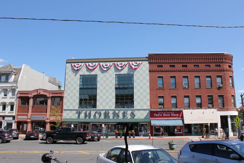
After the fire, the Edwards Church constructed a new building a few blocks away at the corner of Main and State Streets, and this site here at the corner of Old South Street was soon rebuilt with new brick commercial blocks. The Columbian Building, located on the right side where he church once stood, was completed in 1871, and two years later McCallum’s Dry Goods opened in a new building on the site of the Hunt house. Both buildings are still standing today, although the latter has undergone significant changes over the years and is now Thornes Marketplace. As for the other two buildings in the first photo, these were either demolished or altered beyond recognition, and other commercial buildings now stand on those lots.

Main Street from Masonic Street, Northampton, Mass

Looking west on Main Street from near the corner of Masonic Street in Northampton, around 1894. Image from Northampton: The Meadow City (1894).

The scene in 2017:

This scene, on the western end of Main street, was at the outer edges of downtown Northampton for most of the 19th century, and it was not fully developed into its present-day form until the 1870s and 1880s. The oldest building in the first photo is the Edwards Church, located directly in the center of the photo. This congregation was established in 1833 as an offshoot of the First Church, and was named in honor of Jonathan Edwards, the prominent theologian who had served as the pastor of the First Church from 1729 to 1750. The first permanent home of the new congregation was a church at the corner of Main and Old South Streets, but this building was destroyed in a fire in 1870 and, a few years later, the church completed a new building a few blocks to the west, as seen in the first photo.

Around the same time that the new church was built here, Smith College was established on a site just beyond the church, where Main Street divides into West and Elm Streets. The school’s first building, College Hall, was completed in 1875, and can be seen in the distance on the left side of both photos. Like many of the other 19th century buildings on the campus, College Hall was the work of the Boston-based architectural firm of Peabody and Stearns, and was designed in the High Victorian Gothic style that was popular at the time, particularly for schools and other institutional buildings.

The newest buildings in the first photo were the five brick commercial blocks in the foreground on the right side. Known as the Daley Blocks, these buildings were completed around 1886-1887 and were originally owned by Patrick J. Daley, an Irish native who owned a dry goods store in Florence. As the first photo shows, the three buildings in the middle were built with the same architectural style – red brick, with light-colored lintels and sills – but paint and other alterations have obscured these details on the buildings to the left and the right.

Today, aside from these minor changes to the Daley Blocks, the only significant difference in this scene is the Edwards Church. The old church building from the first photo stood here for over 80 years, and during this time it was the home church of Calvin Coolidge and his family, as well as the site of his funeral in 1933. However, by the 1950s it was in in need of serious repairs, and the congregation voted to build a new church rather than renovate the old one. As a result, it was demolished and replaced with the current church building, which was completed in 1958 on the same site as the old church.