Main Street and Eden Avenue, Southington, Connecticut

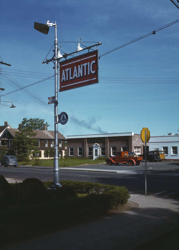
Looking northwest from the corner of Main and Eden in Southington, in May 1942. Image courtesy of the Library of Congress, FSA-OWI Collection.
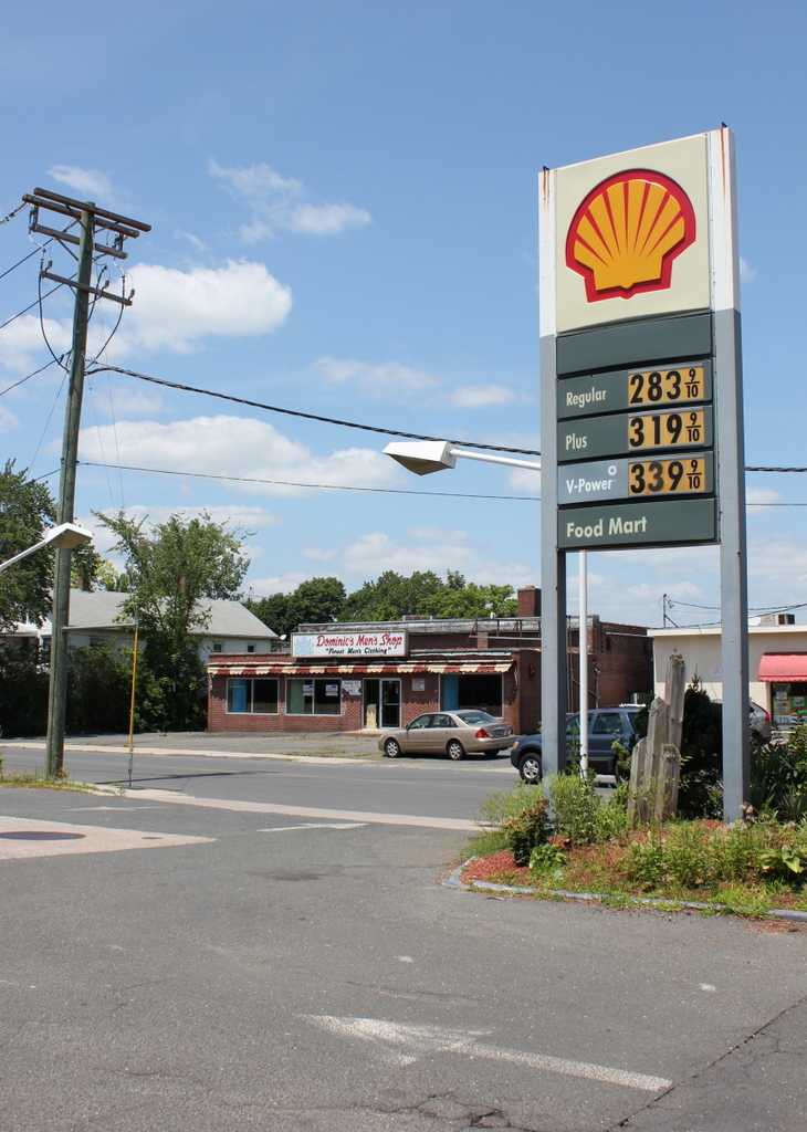
636_1942-05 loc

The scene in 2015:

636_2015
This is the first color “then” photo that I have featured here, and it was taken by the Office of War Information, about six months after the US entered World War II.  The euphemistically-named OWI was essentially the propaganda department during the war, and one of their projects was to create a pamphlet that documented life in an American town.  Southington was chosen as the model, and several hundred photographs were taken in May 1942, including a few color ones.  The idea was to distribute the pamphlet overseas, with the goal of showing the freedom and equality that Americans enjoyed and hopefully gaining sympathy for the American war effort.

The 1942 photo was taken from the parking lot of an Atlantic gas station, with another gas station visible across Eden Avenue on the far right.  Both are still there, although the Atlantic one is now a Shell, and the gas prices are a little higher than they were in 1942, when the average price per gallon was 20 cents.  Across the street in the center of the photo was the home of The Southington News.  The building is still there today, although with an addition on the front.  Because the addition is not as tall as the rest of the building, the top of the original facade can still be seen from this angle.  It was most recently used as a men’s clothing store, but it is now vacant.

Captain Barnes House, Portsmouth, NH (2)

The Captain Barnes House in Portsmouth, NH, on March 19, 1937, immediately following its conversion into a gas station. Image courtesy of the Library of Congress, Historic American Buildings Survey collection.

627_1937-03-19 loc

The building in 2015:

627_2015
As explained in the previous post, this building was once a 1808 Federal style mansion, owned by two different Portsmouth sea captains in the early 1800s.  However, in 1936-37 it was converted into a Sunoco station, leaving very little of the original structure.  However, in a way the renovated building has become historic in its own right, as an example of a 1930s service station.  There have been some changes since the 1937 photo was taken, though.  The shingles have been replaced with vinyl siding, and the gas pumps are gone, along with the windows on the right side and the garage door to the left.  The building now has additions to the left and right, and it is no longer a Sunoco station, but it is still in use as auto repair garage, with a restaurant in the addition to the right.

Market Square, Portsmouth, NH

Market Square in Portsmouth, looking east from the corner of Congress Street and Fleet Street around 1900-1910. Image courtesy of the Library of Congress, Detroit Publishing Company Collection.

625_1900-1910 loc

Market Square in 2015:

625_2015
Unlike some of the other street views of Portsmouth, this scene has actually seen some significant changes over the past century, although two prominent historic buildings from the first photo are still standing today.  In the center of the photo is the North Church, which was built in 1854.  Perhaps owing to the relatively small scale of the old city, the “North” and “South” churches are actually only separated by a single city block, although as time went on it was doctrine rather than distance that distinguished one from the other, with the South Church becoming Unitarian, while the North Church remained more conservative in its theology.  The congregation has met at this site in Market Square since 1712, and over the years this area became the main commercial center of the city.  Some of the oldest surviving commercial buildings in the city can be seen from in front of the church in this post.

The other prominent historical building is the National Block, on the far right side of the photos.  It was built in 1878 by Frank Jones, a mayor, Congressman, and businessman who also owned the Rockingham Hotel, the Hotel Wentworth, and the humbly-named Frank Jones Brewery.  When the first photo was taken, the first floor of the National Block was used by both the Granite State Fire Insurance Company, with the Odd Fellows occupying the upper floors.  Since then, the interior has since been extensively renovated, but its exterior appearance is largely unchanged, and its style has been imitated in the modern commercial buildings between the National Block and the church.

Waterfront, Portsmouth, NH

The view along the Portsmouth waterfront, taken from along Ceres Street looking toward the buildings on Bow Street, around 1900-1906. Image courtesy of the Library of Congress, Detroit Publishing Company Collection.

620_1900-1906 loc

The view in 2015:

620_2015
The angle here isn’t exactly the same,  but the two photos show some of the same buildings while demonstrating some of the change that has occurred along Bow Street.  The four buildings on the far right of the first photo are the same ones seen in the center of the 2015 view, and the two in the center of the first one still exist, but they are out of view from here, obscured by taller, modern buildings to the right of them.  The spire of St. John’s Church, which features prominently in the first photo, is also still there, although from this angle just the very top of the weathervane can be seen above the buildings.

Although many of the buildings are still there, though, the greatest change has been in their use; the waterfront of early 20th century Portsmouth was heavily industrial.  To the right were the offices for Eldredge Brewery, a prominent local brewery that opened in 1858 and operated for nearly a century, with a hiatus during the Prohibition era that came less than 20 years after the photo was taken.  In the center of the first photo, the white building served its purpose as both the home of Preston’s Laboratory and also as a large advertisement for its products.  It offered to customers such necessities as “Cologne Water,” “Tooth Powder,” and “Stedman’s Tu-Tha-Lin,” along with other “Simple remedies at all summer resorts.”  Although primarily industrial, it looks like there were people living here, too – notice the laundry hanging behind some of the buildings.

Today, the waterfront has been redeveloped as an upscale commercial district, with stores and restaurants replacing breweries and drug companies.  Martingale Wharf, the building once occupied by Preston’s Laboratory, is now a restaurant, one of several along this section of Bow Street that offer diners a view of the Piscataqua River.  On the left, in the background of both photos, is the Portsmouth Naval Shipyard.  although technically located in Kittery, Maine, the shipyard has played a major role in Portsmouth’s economy since it was established in 1800.  It is still in use today, specializing in submarine repair and modernization.

Congress Street, Portsmouth, NH

Looking east on Congress Street from Middle Street, around 1905-1915. Image courtesy of the Library of Congress, Detroit Publishing Company Collection.

614_1900-1915 loc

Congress Street in 2015:

614_2015
This view faces down Congress Street toward Market Square, where the photos in this post and this post were taken.  Unlike those views, however, there have actually been some changes here.  When the first photo was taken, this area was on the edge of the Market Square commercial district, so the scene shows a mix of both brick commercial buildings and wood-frame houses.  The houses on the right-hand side date to the mid-1700s, when Portsmouth was the colonial capital of New Hampshire and a major seaport and shipbuilding center.

On the far right is the corner of the Cutter House, which was built around 1750 and subsequently owned by Dr. Ammi R. Cutter, a surgeon in the French and Indian War and the American Revolution.  He later gave the house to his daughter, who married Clement Storer, who was also a doctor and military officer.  He served in the War of 1812, and also served one term in the House of Representatives and two years as a U.S. Senator.  In his 1817 trip to New England, President James Monroe stayed at the house; at the time, Storer was a Senator and a fellow Democratic-Republican.

Beyond the Cutter House is the Leavitt House, which was built prior to 1761 and was the home of Wyseman Clagett, a colonial judge who was infamous for his draconian rulings.  It later went through a series of other owners, and by the mid 1800s was owned by a Miss M. Leavitt, from whom we get the historic name of the house.  The third house down the street, barely visible beyond the Leavitt House, was the home of Colonel Joshua Peirce, a New Hampshire militia officer who purchased it in 1839.  It had been built around 1785, making it by far the newest of these three mansions.

Today, all three of these historic houses are gone, having long ago been replaced with 20th century commercial blocks.  Another 18th century house was demolished not long before the first photo was taken; it had been owned by W.H.Y. Hackett, a lawyer, banker, and politician who lived here for over 50 years.  After his death in 1878, the YMCA used the building until 1905, when they demolished it to build the present-day yellow brick building on the same spot.  This is the only building in the foreground that still exists today, and even then it has been altered.  The bay windows on the second floor have been removed, and the storefront has been heavily altered.  The YMCA used this building until 1957, and today the first floor storefront is home to the Sake Japanese Restaurant.

Market Street, Portsmouth, NH

Looking north on Market Street from the corner of Daniel Street at Market Square in Portsmouth, around 1914-1920. Historic image courtesy of the Library of Congress, Detroit Publishing Company Collection.

613_1910-1920 loc

Market Street in 2015:

613_2015
These photos show a view very similar to the ones in this post, and as was the case there, not much has changed here either.  Market Street is located at the northeastern end of Market Square, and is lined with historic early 19th century commercial buildings on both sides, most of which were built in the immediate aftermath of several disastrous fires in the first couple decades of the 19th century.  These were constructed with fire safety in mind, with brick walls, slate roofs, and firewalls extending above the roofs between buildings.  Most of this street was destroyed in a 1802 fire, and the buildings on the left were built by 1807, when Daniel Webster opened his law office on the second floor of either the building with the yellow storefront or the one beyond it with the maroon awning.

The fireproofing efforts seem to have been successful, because this street was already considered historic when the first photo was taken.  Today, a century after the first photo was taken, and two centuries after most of the buildings were built, everything from the first photo is still there.  Even one of the businesses is still there: Alie Jewelers on the far right side, which was established in 1914 and provides the earliest possible date for the first photo.