Louisburg Square, Boston

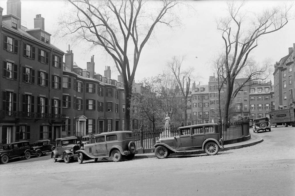
Louisburg Square on Beacon Hill in Boston, on July 5, 1930. Image courtesy of the Boston Public Library, Leon Abdalian Collection.

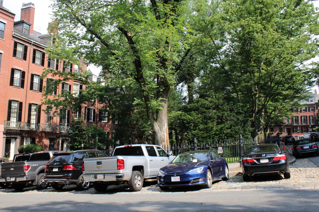
The scene in 2021:


Beacon Hill is one of the best-preserved neighborhoods in Boston, and it generally consists of narrow streets lined with brick rowhouses. However, the one exception to these narrow streets is here at Louisburg Square, a long, narrow park that extends from Mount Vernon Street to Pinckney Street. The square was laid out as part of development of Beacon Hill during the 1820s, and the houses around it were constructed in the 1830s and 1840s. Like most of the other houses in the neighborhood, they are generally three or four stories tall, and many have bow fronts, including a row of eight bow-fronted houses on the left side of the scene.

As for the park itself, it was one of a number of small urban parks that were laid out in Boston during this period. Some have been lost over time, including the Tontine Crescent on Franklin Street and Pemberton Square just to the east of Beacon Hill, but Louisburg Square has remained largely unchanged since the mid-19th century. The park is privately owned and maintained by the residents of the square, and in 1846 they added the cast iron fence around the perimeter of the park, followed by statues of Aristides the Just and Christopher Columbus in 1850. The square also briefly had a fountain, which was installed in 1850 but removed in 1856.

Over the years, Louisburg Square has had a number of prominent residents, particularly in the literary world. The house at 10 Louisburg Square—the second bow-fronted house from the left in this scene—was the final home of Louisa May Alcott and her father Bronson Alcott. They lived here for several years in the 1880s, until their deaths two days apart in March 1888. Also in the 1880s, novelist William Dean Howells lived at Louisburg Square, first at number 16 in 1882, and then at number 4 from 1883 to 1884. One of the houses near the end of the street, at 20 Louisburg Square, was the home of author and banker Samuel Gray Ward, who was also one of the founders of the Metropolitan Museum of Art. In 1852, prominent Swedish opera singer Jenny Lind married her husband, Otto Goldschmidt, in this house. Much more recently, prominent Louisburg Square residents include former U.S. Senator and Secretary of State John Kerry, who lives in the house on the right side at the far end of the street.

By the time the first photo was taken in 1930, the houses on Louisburg Square were already nearly a century old, yet not much had changed here in the intervening years, aside from the addition of automobiles on the streets around the square. Today, nearly a hundred more years have gone by, and still Louisburg Square has remained well-preserved. It is the centerpiece of the Beacon Hill neighborhood, and all of the houses in this scene are now part of the Beacon Hill Historic District, which was designated as a National Historic Landmark district in 1962.

61-63 Mount Vernon Street, Boston

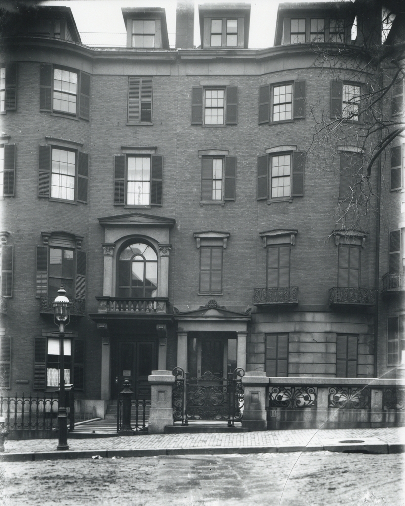
The houses at 61 and 63 Mount Vernon Street in Boston, on March 20, 1909. Image courtesy of the City of Boston Archives.

The buildings in 2021:

These two photos were taken near the same spot as the ones in the previous post, and they show two rowhouses on Mount Vernon Street in Boston’s Beacon Hill neighborhood. This area was developed in the early 19th century, and these two lots were once part of a much larger property owned by Senator Jonathan Mason. After Mason and his wife Susan died in the 1830s, their mansion was demolished and the land was subdivided into smaller lots for new houses. Among the housed built here were the two in the first photo, at 61 and 63 Mount Vernon Street. Built around 1837, their design was typical for Beacon Hill homes of this period; they were brick, four stories in height, with a bowed front façade and three window bays.

The house on the left, at 63 Mount Vernon Street, was originally owned by merchant William Sawyer. Subsequent owners included William Mason, the son of Jonathan Mason, but the most prominent resident here was William Claflin, who lived here from around 1870 until his death in 1905. Claflin was a shoe manufacturer and politician who served as lieutenant governor from 1866 to 1869, and then as governor from 1869 to 1872. He was also involved in national politics, serving as chairman of the Republican National Committee from 1868 to 1872, and he served two terms in the U.S. House of Representatives from 1877 to 1881. In addition to this, he was a major donor and namesake of Claflin University, a historically black university in South Carolina, which was established to educate recently-emancipated former slaves.

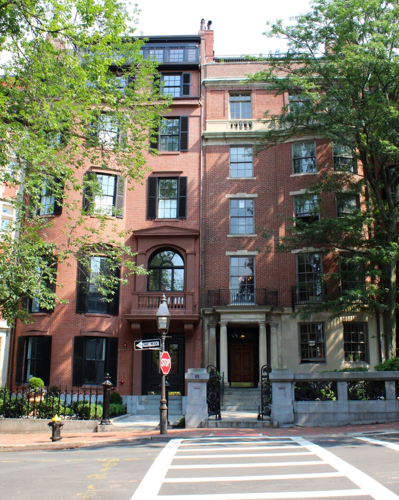
As for the house on the right, at 61 Mount Vernon Street, it was built around the same time as its neighbor, but it does not appear to have had any particularly prominent residents. According to the state’s MACRIS inventory form on this house, its original owner was Jonathan Phillips, but over the course of the 19th century its subsequent residents included William Minot, John C. Gray, and John C. Bancroft. The house was still standing when the first photo was taken in 1909, but it was demolished soon after. Its replacement, which is shown in the 2021 photo, was built in 1911, and it is of similar size and appearance to its predecessor, although with more Classical Revival-style features.

Today, the house at 63 Mount Vernon Street is still standing, although it has been altered since the first photo was taken, most significantly with the addition of a fifth floor. Overall, though, the house retains much of its historic exterior appearance, and even the newer house next door at 61 Mount Vernon Street fits in well with its surroundings, despite the different architectural details. Both houses are now part of the Beacon Hill Historic District, which was designated as a National Historic Landmark district in 1962.

Mount Vernon Street, Boston

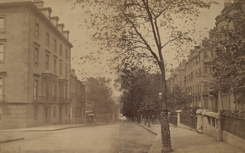
Looking west on Mount Vernon Street from near the corner of Walnut Street in Boston’s Beacon Hill neighborhood, around 1860. Image courtesy of the Boston Public Library.

The scene in 2021:

For more than two centuries, Beacon Hill has been one of the most desirable residential neighborhoods in Boston. During the colonial period, this area was primarily hilly pastureland on the outskirts of town, but in 1798 it became the site of the Massachusetts State House, which still stands at the southeastern corner of the neighborhood. Residential development soon followed, consisting largely of brick, Federal-style row houses. Over the years, many prominent people have lived here on Beacon Hill, and it remains a remarkably well-preserved early 19th century neighborhood.

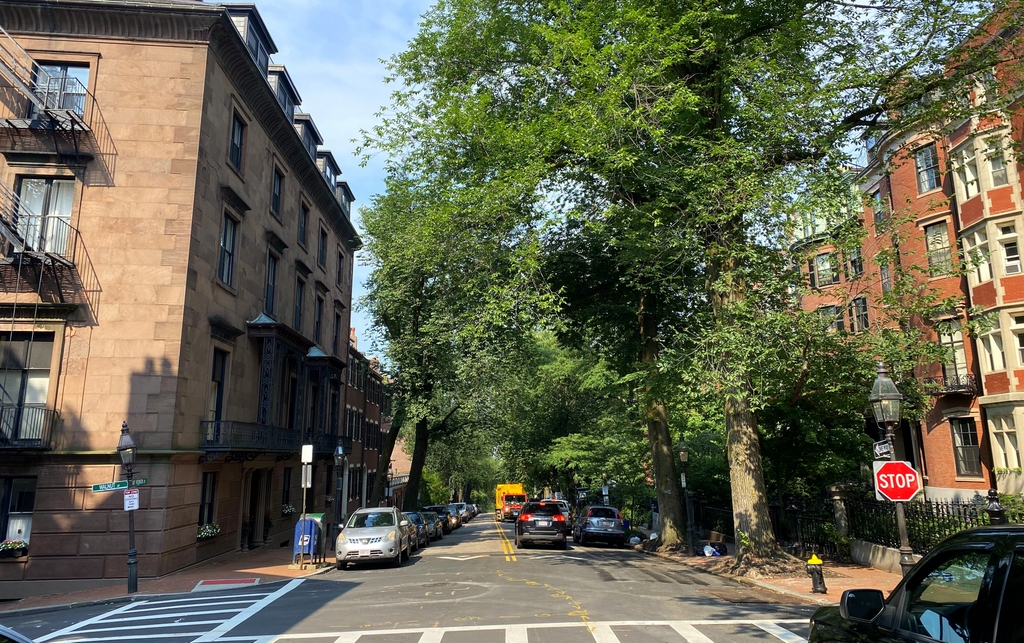
These two photos show the view looking west on Mount Vernon Street from the corner of Walnut Street, near the crest of the hill. Nearly all of the buildings from the first photo are still standing more than 160 years later, with the exception of the one on the far right, which was demolished around 1905-1910 in order to build the current Tudor Revival-style building. Aside from this one, the other houses on the right side of the street in this scene all date back to the first half of the 19th century. The two closest to the foreground, just past the Tudor-style building, were both built in the 1830s, and the both feature a bowed front façade, which is a distinctive feature on many Beacon Hill homes.

On the left side of the street, the most distinctive houses are the two brownstone homes in the foreground at 40 and 42 Mount Vernon Street. These were among the first houses in the neighborhood to be built of brownstone rather than brick, and they were both designed by architect George Minot Dexter. Both were built for prosperous merchant Augustus Hemenway, who lived in the house at the corner, at 40 Mount Vernon Street. He was still living here when the first photo was taken around 1860, and both houses remained in his family until the early 20th century.

Just past these houses are three comparatively modest brick rowhouses, which were built around 1825, and further in the distance are three single-story buildings. These are probably the oldest buildings in this scene, dating back to 1804 when they were built as carriage houses for homes on nearby Chestnut Street. Despite their small size and humble origins, all three have survived to the present day, and have since been converted into residences.

Overall, with the exception of the present-day cars and paved roads, very little has changed in this scene since the first photo was taken. This is generally true throughout much of the neighborhood, and because of this level of preservation, Beacon Hill was designated as a National Historic Landmark district in 1962.

King’s Chapel Burying Ground, Boston

The scene in the King’s Chapel Burying Ground in Boston, around the 1920s. Image courtesy of the Boston Public Library.

The scene in 2021:

King’s Chapel Burying Ground is the oldest cemetery in Boston, dating back to the very beginning of the European colonization of the area. According to tradition, the first burial here was Isaac Johnson, one of the wealthiest and most influential of the original settlers of the Massachusetts Bay Colony. He had extensive landholdings, but he died in September 1630, only a few months after his arrival in the New World. As the story goes, Johnson was buried on his property in Boston, and as other people died in the coming months and years, they were likewise buried here.

In reality, there is no contemporary evidence to indicate that Johnson was even buried in Boston, let alone in this specific plot of land. The earliest account of this story was written nearly 50 years after the fact, in the diary of Judge Samuel Sewall. But, one way or another, this site became a burial ground very early in Boston’s history, although the exact date is uncertain. It would remain the town’s only cemetery until 1659, when Copp’s Hill Burying Ground was established in the North End.

There are no surviving gravestones from the early burials here. The oldest is dated 1658, for William Paddy, although this stone had an interesting history. Paddy was presumably buried here at King’s Chapel, but the gravestone itself was discovered buried under the street next to the Old State House in 1830. It seems highly unlikely that Paddy would have been buried there, and there were no human remains in the vicinity, so the stone was probably removed from the burying ground at some point, perhaps in the 1700s, and repurposed as something else. In any case, it was safely returned here after its discovery in 1830, and has remained here ever since.

Gravestones became more common here during the late 1600s and early 1700s, often with highly ornate, intricate carvings decorated with images of skulls and other symbols of death. Perhaps most notable among them is the gravestone of Joseph Tapping, a large slate stone that stands at the entrance to the graveyard. It is dated 1678, and it features a scroll pediment at the top, and beneath it is a large hourglass atop a winged skull. Beneath the skull is a striking image of a skeleton, likely symbolizing death, trying to extinguish a candle while Father Time tries to restrain him. Another notable gravestone is that of Elizabeth Pain, dated 1704. It likewise features a skull and hourglass, but it also has a large coat of arms carved into it. This design somewhat resembles a capital “A,” which has led some to speculate that this gravestone inspired Nathaniel Hawthorne to write The Scarlet Letter.

In the meantime, in 1688 King’s Chapel was built on the southern portion of the graveyard. It was the first Anglican church in a town that was otherwise dominated by Puritanism, and this was the only land that the church officials were able to acquire. It was originally built of wood, although it was later rebuilt with stone in 1754, as shown in these two photos. The church was not at all affiliated with the graveyard, but, because of its proximity, it came to be known as King’s Chapel Burying Ground, and the name has stuck ever since.

The graveyard continued to be used throughout the 18th and into the early 19th centuries. However, by that point Boston was growing rapidly, and the old burial grounds such as this one were becoming overcrowded and, in the minds of many, posed health risks. So, in 1831 the Mount Auburn Cemetery was established in Cambridge and Watertown, in the suburbs of Boston. In contrast to the crowded, urban setting here, this new cemetery would be laid out like a rural park. And, while the old graveyards featured gravestones with grim, Puritan-era reminders of death, Mount Auburn would have monuments that were generally more neoclassical in style.

By the time the first photo was taken around the 1920s, King’s Chapel Burying Ground had not been used as an active cemetery for many decades. And, in the meantime, many of the old gravestones had been rearranged during the 19th century, evidently to create more orderly rows of stones. As a result, the location of many of the stones no longer corresponded to the site of the remains that they were intended to mark. This practice continued after the first photo was taken, and today the arrangement of the stones is very different from a century ago, as shown in the present-day photo.

Today, King’s Chapel Burying ground is a popular stop on the Freedom Trail, and a nice summer day will find many tourists circulating through the old graveyard. None of the particularly famous gravestones are readily visible in this scene, although the obelisk in the center of the photo stands out amid the otherwise relatively small colonial-era stones. It marks the gravesite of Thomas Dawes, a builder and architect who was also a militia colonel during the American Revolution. Just beyond the obelisk is a tomb that was long believed to have been the final resting place of William Dawes Jr., Thomas’s cousin. He had been one of the riders who, along with Paul Revere, warned of the advancing British redcoats before the Battles of Lexington and Concord. However, it appears that he is actually buried at the Forest Hills Cemetery in Jamaica Plain.

Aside from the graveyard itself, a few of the surrounding buildings are still standing from the first photo. Most notably is King’s Chapel itself, which remains an active church, although it has been a Unitarian congregation—rather than Anglican—ever since the end of the American Revolution. Further in the distance, on the right side of the scene, the other survivor from the first photo is the Tremont Building. Constructed in 1895, this office building still stands at the southwest corner of Tremont and Beacon Streets, and it is currently part of the Suffolk University campus.

St. Stephen’s Church, Boston

Looking north on Hanover Street in Boston, with St. Stephen’s Church in the center of the scene, around 1895-1905. Image courtesy of the Boston Public Library.

The scene in 2018:

These photos show the view looking north on Hanover Street from about the corner of Tileston Street, in Boston’s North End. The most prominent building here in this scene is St. Stephen’s Church, which is located directly opposite the Paul Revere Mall. Although it is currently a Roman Catholic church, it was constructed in 1804 as a Congregational church. It was originally known as the New North Church, as opposed to the more famous Old North Church less than 200 yards away, and it was the work of prominent architect Charles Bulfinch, who was responsible for designing many important buildings in early 19th century Boston.

This church was built around the same time that Unitarian theology was causing divisions within Congregational churches across New England. In 1813, New North became Unitarian, as did a number of other Congregational churches in Boston. That same year, 25-year-old Francis Parkman became its pastor. He would go on to serve the church for the next 36 years, and he was also the father of Francis Parkman Jr., who went on to become a noted historian and writer.

By the mid-19th century, the demographics of the North End had changed. As new, more desirable neighborhoods were developed in other parts of the city, affluent North End residents had steadily left the area. These largely Protestant, native-born residents were replaced by Irish Catholic immigrants, who settled in large numbers here in the North End. With its congregants leaving the increasingly crowded and impoverished neighborhood, the New North Church was ultimately sold in 1862 to the Roman Catholic Diocese of Boston, becoming St. Stephen’s Church.

The church building subsequently underwent some changes, including alterations to the original cupola. In 1870, it was moved back 16 feet when Hanover Street was widened, and it was also raised six feet on a new, higher foundation, in order to create a lower level. The interior was also modified, and it saw further changes after being damaged by fires in 1897 and 1929.

The first photo shows the church, and its surroundings on Hanover Street, around the turn of the 20th century. By this point, the North End was no longer predominantly Irish. Instead, the neighborhood was filled with newer immigrant groups, particularly Italians, and the North End was well on its way to becoming known as Little Italy. However, some of the Irish parishioners maintained their connections to St. Stephen’s Church, including John F. Fitzgerald, who was a congressman and mayor of Boston. His daughter Rose – the mother of John F. Kennedy – was baptized here in 1890, and her funeral was held here 104 years later, in 1995.

Out of the five churches that Charles Bulfinch designed in Boston, this church is the only one that survived into the 20th century. By the 1960s it was also one of his few remaining churches anywhere, and it was recognized for its historic and architectural significance. From 1964 to 1965, it underwent a major renovation, which included lowering the building to its original level and restoring the cupola. The interior was also restored during this time, although it is somewhat different from Bulfinch’s original plans.

Today, St. Stephen’s Church is still an active Roman Catholic parish, and the restored building stands as an important architectural landmark in the North End. The surrounding streetscape has seen some changes since the first photo was taken around 120 years ago, with the most obvious being the three buildings on the right side, which were constructed around 1905. Overall, though, this scene has maintained the same scale since the late 19th century, which still consists primarily of four-story brick commercial blocks, and the North End remains a remarkably well-preserved section of Boston.

John Hancock House, Boston

The John Hancock House on Beacon Street in Boston, around 1860. Image courtesy of the Boston Public Library.

The scene in 2017:


This grand mansion was built in the mid-1730s for Thomas Hancock, a wealthy Boston merchant. At the time, Beacon Hill was on the outskirts of Boston, and this house was the westernmost one on Beacon Street. Here, Thomas and his wife Lydia created what amounted to a country estate, with gardens, orchards, and pastureland that extended up the southern slope of hill, and was directly across the street from Boston Common. Despite the pastoral setting, though, the was within easy walking distance of Boston’s wharves, where Hancock conducted his business. The house itself was built of granite, and was an outstanding example of Georgian architecture, complete with a balcony that offered sweeping views of Boston and the the surrounding harbor.

Thomas and Lydia had no children of their own, but in 1744 Thomas’s brother John died, and his seven-year-old son, also named John, moved to Boston and lived here in this house. After graduating from Boston Latin School in 1750 and Harvard College in 1754, John Hancock joined his uncle’s firm, eventually taking over the business after Thomas’s death in 1764. Along with the business, he also inherited his uncle’s estate here on Beacon Hill, and he went on to live here for the rest of his life.

John Hancock went on to become one of the most prominent Patriots in the years leading up to the American Revolution, and in 1774 he was elected as a Massachusetts delegate to the Second Continental Congress. From 1775 to 1777, he served as the President of the Continental Congress, and it was in this capacity in 1776 that he famously signed the Declaration of Independence. Following his time in Congress, he briefly served in the war as a major general in the Massachusetts militia, and in 1780 he was elected as the first governor of Massachusetts. Widely popular, he easily won re-election every year until 1785, when he resigned due to ill health.

Later in 1785, James Bowdoin was elected as his successor, but his two years as governor were marked by a failing economy and a poor response to Shays’ Rebellion in 1786-1787. As a result, Hancock ran against him in the 1787 election and won easily, and he went on to win re-election every year until his death in 1793. During this time, he pardoned those involved in Shays’ Rebellion, and he was also an influential proponent of the U.S. Constitution, which was narrowly ratified by the state in 1788, probably thanks to his support. In the absence of an official governor’s mansion, Hancock’s house served that purpose well, and he received a number of distinguished visitors here, including the Marquis de Lafayette in 1781 and George Washington in 1789.

By the time John Hancock died in 1793, this house was no longer at the outskirts of Boston, and Beacon Hill was in the process of being transformed into an exclusive neighborhood of elegant townhouses. Portions of the estate were steadily sold, including land to the east of the house, which became the site of the Massachusetts State House. Other parcels were sold for new homes, and by the early 19th century the house was surrounded by more modern homes. Hancock’s widow, Dorothy, had remarried in 1796, and she lived here in this house until 1816. The house remained in the family, though, with John Hancock’s nephew, also named John, owning the house until his death in 1859.

The first photo was taken sometime around the time when the younger John Hancock died, and it shows his granddaughter, Elizabeth Lowell Hancock Moriarty, standing on the second floor balcony. Despite being over a century old, the house still retained its stately elegance, and was recognized as an important landmark. There had been several different proposals for using the house, including the possibility of purchasing it as an official governor’s mansion. The family even offered the property to the state for the low price of $100,000, but many balked at the idea of such an expense, and the idea was dropped.

The property was finally sold in 1863, with the intention of redeveloping it with modern townhouses. The state was offered one last chance to move the house to a new location, but again there was significantly opposition to the $12,000 expense, and the historic house was ultimately demolished in the summer of 1863. Had it survived, the house would have become one of the city’s iconic Revolutionary War landmarks, on par with such places as the Old State House, the Paul Revere House, and Old North Church. Instead, though, its demolition did help to spur preservation movements for some of these other landmarks, including the Old South Meeting House, which survived similar redevelopment threats a decade later.

In 1865, two townhouses were built on the site of Hancock’s house. However, these houses did not last nearly as long as their predecessor, because in 1917 they were demolished to build a new wing of the Massachusetts State House. Since then, not much has changed. The 1798 state house, with its various additions over the years, remains in use as the state capitol building, and the surrounding Beacon Hill neighborhood is still home to many of Boston’s wealthy residents, nearly 300 years after Thomas Hancock first made his home here.