Main Street, Concord, Mass

The view looking west on Main Street, from the corner of Lexington Road in Concord, around 1910-1920. Image courtesy of the Library of Congress, Detroit Publishing Company Collection.

The scene in 2018:

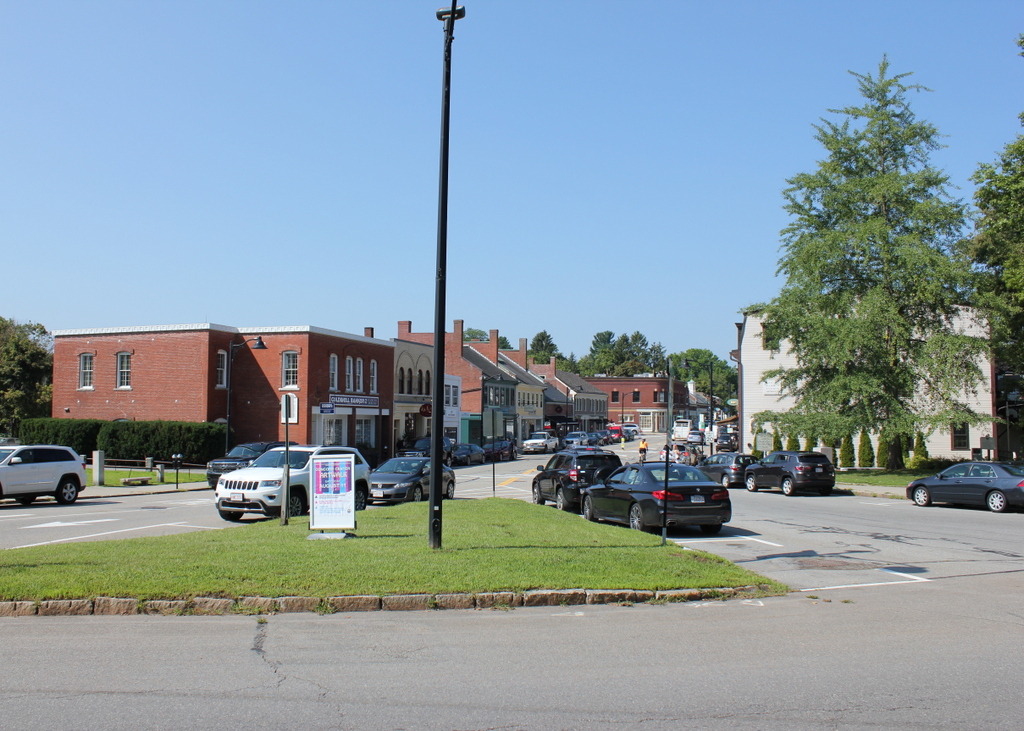
These two photos were taken more than a century apart, from the small rotary at the intersection of Monument Road, Lexington Road, and Main Street in downtown Concord. The view is facing west down Main Street, showing a variety of low-rise commercial buildings, most of which date back to the 19th century. Aside from some obvious modern changes, such as an increase in automobiles on the road and a lack of trolleys in the present-day photo, remarkably little has changed in this scene, and most of the historic buildings here on Main Street remain well-preserved.

This block of Main Street was originally known as the Milldam. Starting in the 17th century, the site of the street was a dam across the Mill Brook, and over the years it steadily grew to include a variety of offices and stores on top of the dam itself. Then, in 1828 the Milldam Company was formed, and it purchased the land on either side of the dam. The pond was subsequently drained, the old buildings on the dam were demolished, and new lots were laid out. The result was new commercial buildings on either side of Main Street, and many of these are still standing today.

Starting on the far left side, the closest building to the foreground of the two photos is Garty’s Block, which came several decades after the milldam was reconstructed. It dates back to around 1870, and it originally had a Second Empire-style mansard roof, as shown in the first photo. This has since been removed, and the ground floor storefront has also been altered at some point in the 20th century, leaving only the second floor relatively unaltered from the exterior. Just to the right of it, at 15-17 Main Street, is a two-story building that once housed Alexander Urquhart’s bakery. It was constructed in 1898, replacing an earlier wooden structure on the same site, and it still stands today, with fewer dramatic changes than its neighbor to the left.

Further in the distance is a pair of two-story buildings with gabled roofs and high chimneys on their end walls. These features distinguish them from later 19th century commercial blocks, which tended to have flat roofs and less prominent chimneys. Both buildings were part of the Milldam Company’s redevelopment of the area, and they were constructed sometime around 1835. Like most of the other buildings here, the ground floors have been altered, but otherwise they have retained much of their original appearance.

Just beyond these two buildings, in the first photo, is a small two-story Italianate-style building that probably dated back to around the 1850s or 1860s. This is one of the few buildings from the first photo that is no longer standing; it was demolished by the early 1930s, when the present-day building—originally a First National Store—was constructed on the site. On the other side of it is the Davis-Richardson Block at 37 Main Street, which features a design similar to the nearby 1835 buildings. This block is slightly newer, though, having been built around 1845.

Some of the other 19th century buildings in this scene include the Friend’s Block, the two-story brick building that stands in the distance in the right-center of the photos, at the corner of Main and Walden Streets. It was built in 1892, making it one of the newer structures here on this section of Main Street. On the other side of the street, on the far right of both photos, is the Union Block at 18-26 Main Street. Like Garty’s Block across the street, it was built with a mansard roof, but in this case the roof has been retained, and the exterior of the building has not changed significantly over the years.

Although very little has changed here since the first photo was taken, this block of Main Street faced the possibility of demolition during the early 20th century. In the late 1920s, cement manufacturer Albert Y. Gowen purchased many of these properties, with the intention of demolishing all of them and replacing them with new colonial-style buildings. Gowen had been inspired by the newly-reconstructed Colonial Williamsburg in Virginia, and he hoped to create something similar here, with a Main Street lined with faux-colonial shops. However, this plan faced significant opposition, including from some of the property owners who refused to sell, and Gowen ultimately abandoned his plans. As a result, Concord continues to have a town center filled with authentic 19th century buildings, as opposed to entirely fabricated 18th century ones.

Wright’s Tavern, Concord, Mass (2)

Wright’s Tavern on Lexington Road in Concord, around 1900-1910. Image courtesy of the Library of Congress, Detroit Publishing Company Collection.

The scene in 2018:

As discussed in more detail in the previous post, this building was constructed in 1747 as a tavern. It was originally owned by Ephraim Jones, but it changed hands several times during the mid-18th century. By the 1770s, it was owned by Daniel Taylor but operated by Amos Wright, whose name has come to be associated with the tavern because of several important events that occurred here at the start of the American Revolution.

In October 1774, the Massachusetts Provincial Congress met in Concord in defiance of the Intolerable Acts, which had dissolved the colonial legislature. The delegates met nearby in the First Parish Church, but they held committee meetings here at the tavern, in addition to visiting here for food and drink. About six months later, on April 19, 1775, the tavern became a gathering place for minutemen prior to the Battle of Concord, and later in the day it was briefly used as the headquarters of Major John Pitcairn, while he searched the town for munitions.

After the war, the tavern became a bakery, which remained in operation until 1831. From there, it went through a series of commercial tenants over the years before eventually being acquired and restored by the neighboring First Parish Church. The first photo was taken only a couple decades later, showing the tavern as it appeared at the turn of the 20th century. Since then, the tavern has remained largely the same, and it stands as one of the most historic buildings in Concord, having been designated as a National Historic Landmark in 1961.

Wright’s Tavern, Concord, Mass (1)

Wright’s Tavern, seen from Lexington Road in Concord, around 1910-1920. Image courtesy of the Library of Congress, Detroit Publishing Company Collection.

The scene in 2018:

This tavern has stood at the center of Concord for nearly 275 years, since its construction in 1747. It was built by Ephraim Jones, who ran the tavern here for several years before selling the property to Thomas Munroe in 1751. After Munroe’s death in 1766, it was purchased by Daniel Taylor, and he went on to own it for the next nine years. During this time, in the years leading up to the American Revolution, the tavern served as a popular gathering place for locals. These included the militiamen who met regularly on the nearby training field for drills, as well as congregants from the neighboring First Parish Church.

The tavern came to be known as Wright’s Tavern because of Amos Wright, who was the proprietor during the mid-1770s. Although he did not own the property, he ran the tavern, and it was during his tenure here that several historic events occurred. The first of these came in October 1774, when the Massachusetts Provincial Congress met in Concord. Earlier in the month, the colonial legislature had been dissolved as part of the so-called Intolerable Acts, but its members ignored this directive and met anyway, convening in Concord on October 7. The Congress itself met in the First Parish Church, with John Hancock presiding, but the tavern was used for committee meetings, in addition to providing food and drink for the 300 delegates in attendance.

Just six months later, Wright’s Tavern again found itself at the center of revolutionary activities in Massachusetts. In the early morning hours of April 19, 1775, Concord minutemen gathered here in advance of the approaching British forces, which were attempting to seize colonial military supplies that were stored here in town. Later in the day, these minutemen retreated to the north of town, on the other side of Old North Bridge, where they fired the famous “Shot heard round the world.”

In the meantime, though, the British temporarily occupied the center of Concord, and Major John Pitcairn made the tavern his headquarters. From here, he dispatched search parties in a largely unsuccessful attempt to find the military supplies. He also reportedly ordered a drink here at the tavern, which he is said to have stirred with his finger while declaring that he would “stir the damned Yankee blood” in the same manner by nightfall. However, as it turned out, the colonial minutemen defeated the British at Old North Bridge, and Pitcairn and his men were forced to retreat to Boston. Pitcairn returned safely, but he was ultimately killed two months later at the Battle of Bunker Hill.

After the war, the old tavern became a bakery, with residential space for the baker on the upper floor. Starting in 1790, the bakery was run by Francis Jarvis, and it became a fixture here in the center of Concord for many years. Jarvis sold baked goods out of the building here, but part of his business also involved a wagon route that sold bread, pies, and other goods throughout the surrounding towns. His son, Francis Jr., was born here in 1794, and he would later become a partner in the bakery before taking it over from his father in 1824. The younger Francis operated the bakery for another seven years, before selling the property in 1831.

Over the next few decades, the building housed a variety of commercial tenants, ranging from the print shop to the manufacturer of Potter’s Hair Balm. By the late 19th century, the building was in poor condition, but in the 1880s it was purchased by Reuben Rice and former U.S. Attorney General Ebenezer Hoar, with the goal of preserving the historic structure. They then donated it to the First Parish Church, and it was subsequently converted back to its original use as an inn.

The first photo was taken around 30 years later, showing the old colonial-era tavern at the dawn of the automobile age. One such car is visible on the right side of the photo, with a group of occupants climbing into it, presumably after staying at the hotel or eating in its dining room. The exterior of the building is covered with a variety of signs, attesting to its historical significance as well as the amenities offered here. Another sign, located at the corner on the left side, indicates that it is an “Automobile Red Book Station.”

Today, around a century after the first photo was taken, the exterior of the tavern remains essentially the same as it did back then. It is still owned by the church, although it is no longer used as a hotel. Instead, part of the building is used by the Concord Museum for educational space, and another part of the building is occupied by two architectural firms. Because of its historical significance, the tavern was named as a National Historic Landmark in 1961, making it one of six sites in Concord to receive this level of recognition.

Forest Park Lily Ponds, Springfield, Mass

The lily ponds in Forest Park in Springfield, around 1907. Image courtesy of the Library of Congress, Detroit Publishing Company Collection.

The scene in 2018:

Forest Park is the largest public park in Springfield, encompassing 735 acres of land in the southwestern corner of the city. The origins of the park date back to 1884, and over the years it has been steadily expanded through various donations and land purchases. One of the most significant of these donors was Everett H. Barney, a local ice skate manufacturer who owned much of what is now the western section of the park. He built his house, Pecousic Villa, on the property in 1883, and he subsequently landscaped the grounds with ponds, fountains, a waterfall, bridges, and a network of paths.

Barney had intended to construct a house here for his only child, George. However, George died in 1889, and Barney instead built a mausoleum for his son on the site of what would have been his house. With no other heirs, Barney donated his entire estate to the city, including the house and the meticulously-maintained grounds. His only stipulation was that he and his wife Eliza would be able to reside in the house for the rest of their lives, and they went on to live here until her death in 1905 and his in 1916.

The first photo was taken sometime around 1907, showing the lily ponds that Barney had constructed. It was taken from the path between the lily ponds and the Pecousic Brook, and the view faces north, with Pecousic Villa just out of view on the far left side, on the other side of the hill. Unlike the other sections of Forest Park, which were left in more or less a natural state, this scene was mostly artificial, and the plan was not necessarily admired by all. For example, in 1901 the Springfield Republican published a lengthy commentary on the park, in which it lamented that “Not all the changes of recent years have been for the better.” The article went on to explain:

Everyone must admire the enthusiasm with which Mr. Barney has cultivated the extensive grounds which he has generously added to the park, and criticism of the results would be a most ungrateful task, yet it must be clear from the principles which have been indicated, that a somewhat difficult problem is raised by the conflicting ideals which have been pursued. The rare beauty of the lotus and lily ponds is undeniable, but the general scheme of the park and that of Mr. Barney’s very valuable addition are incongruous. In the park the effort has been to keep as much of nature as is possible in a city park. Mr. Barney’s plan, carried out with diligent personal attention through many years, has involved a design which, though not conventional, is at least artificial.

This criticism notwithstanding, Forest Park proved to be a popular recreation area, with most visitors evidently remaining unfazed by the inconsistencies between the more natural eastern half of the park and the carefully-manicured areas here in the western half. One of the city’s other newspapers, the Springfield Union, praised Barney for his landscaping work in his obituary in 1916, writing:

Forest Park is Springfield’s great breathing ground, and a trip there always includes a visit to “Barney’s front yard.” There he showed his passionate love for nature and that he was an expert horticulturalist. He planted there rare shrubs and trees from Europe, Egypt, China, Japan and India, and there he planned and maintained lily ponds containing nearly all varieties of lilies. There, too, he maintained a lotus pond. Mr. Barney’s nature was a restless, untiring one, and he changed his lawns and flower gardens frequently. His taste ran strongly to mathematical arrangement of flower beds and shrubs, and one is constantly startled by coming suddenly on a stone deer or other piece of statuary.

Today, more than a century after the first photo was taken, Forest Park has undergone some significant changes, including the demolition of the Barney house in the late 1950s to make way for Interstate 91. However, many other scenes in the park, including this one, have remained largely the same. Forest Park is actually much more forested now than it was when it acquired its name, and there are far more trees in the present-day photo, including in the foreground and on the distant hillside. Overall, though, Barney’s lily ponds still look as they did when he first laid them out in the late 19th century, and much of his other landscaping work remains intact after having been enjoyed by many generations of Springfield residents.


Crawford House, Carroll, New Hampshire

The Crawford House at Crawford Notch in the White Mountains of New Hampshire, seen from across Saco Lake, around 1891-1910. Image courtesy of the Library of Congress, Detroit Publishing Company Collection.

The scene in 2018:

The first photo shows the Crawford House, one of the many large hotels that were built in the White Mountains during the second half of the 19th century. It stood just to the north of the gates of Crawford Notch, one of the most important mountain passes in the region. The location of the hotel was near the high point of the notch, at the divide that separates the watersheds of the Ammonoosuc and Saco Rivers. In the foreground of this scene is Saco Lake, which forms the headwaters of the Saco River. From here, the river flows southeast through Crawford Notch before emptying into the Atlantic Ocean just south of Portland, Maine. Less than a half mile to the north of here, on the other side of the hotel, is Ammonoosuc Lake, which ultimately drains into the Connecticut River and then to Long Island Sound.

This site was an ideal location for a hotel. At the time, this road was the only east-west route through the mountains, and this area to the north of Crawford Notch was relatively broad and flat, unlike the long, narrow valley to the south of here. The first hotel in this immediate vicinity was the Notch House, which was built in 1828 by Ethan Allen Crawford. He was the son of Abel Crawford, the first white settler to live near the notch, and his family operated several taverns in the area. Ethan’s brother Thomas became the manager here at the Notch House, and he ran it until 1852, two years before it was destroyed by a fire.

The Notch House was located near the spot where these two photos were taken, but around 1850 Thomas Crawford began construction of a new hotel nearby, on the site of the hotel in the first photo. However, he ran into financial problems before it was completed, and he had to sell the property in the early 1850s. The new owner finished the hotel, which became known as the Crawford House, but, like the Notch House, it fell victim to fire, burning on April 30, 1859.

Such fires were not uncommon in large resort hotels of this period, which were generally made almost entirely of wood and lacked effective fire suppression systems. Despite this setback, though, the hotel was quickly rebuilt. The work began on May 10, 1859 and it was completed in just two months, with the hotel holding a celebratory dinner here on July 13. This new Crawford House, which was still standing when the first photo was taken, was three stories high and originally measured about 200 feet in length, with two wings that extended back about the same distance. Overall, it was much larger than the old building on the site, and a July 1859 article in the Boston Evening Transcript declared it to be the largest hotel in the state.

Another New England newspaper, the Independent Democrat of Concord, New Hampshire, published a letter around the same time that the hotel opened. The letter described a journey through the White Mountains, and it paid particular attention to the new Crawford House. The writer commented on how quickly the hotel was built, and also provided a glowing description of its interior, writing:

It is not too much to say that the “New Crawford house” is an advance upon any other at the Mountains. Its dining hall is of magnificent proportions, measuring 85 feet by 40, and 14 feet high. The principal parlor is 60 feet by 40. The general reception room is large and airy; while the sleeping rooms, of which there are some 120, are large, high, and thoroughly ventilated, leaving nothing, in these respects, to be desired. Then, the whole house is to be furnished in the most elegant and substantial style, and the whole is to be lighted with gas.

Guests at the Crawford House could enjoy a variety of outdoor activities. There were short hikes to places such as Ripley Falls, Arethusa Falls, and the summit of nearby Mount Willard, and for the more ambitious there was the Crawford Path, which led 8.5 miles to the summit of Mount Washington. This trail, which began here at the Crawford House, was created by Abel and Ethan Crawford in 1819, and it was eventually incorporated into the Appalachian Trail, making it probably the oldest active hiking trail in the country today. Guests could hike these trails on their own, but the hotel also had ponies that they could ride, along with experienced guides to accompany them.

In 1870, the Crawford House was purchased by brothers Asa T. and Oscar F. Barron. At the time, they also operated the nearby Twin Mountain House and Fabyan House, and their hotel empire would subsequently include the Mount Pleasant House and the Summit House, which was located at the top of Mount Washington. Oscar died here at the Crawford House in 1879, and Asa died eight years later, but the Barron family would continue to run these hotels for many years.

For the first two decades of its existence, the Crawford House was not directly served by railroads, but in 1875 the Portland & Ogdensburg Railroad opened through Crawford Notch, making the hotel far more accessible to visitors. At the time, it was the only hotel in the vicinity of the notch, and it received a glowing review in the 1887 Chisholm’s White-Mountain Guide-Book, which included the following description:

[T]his is a good hotel of the first class, 1,900 feet above the sea, with broad and almost interminable piazzas, cool and airy halls, post-office, telegraph-office, livery-stable, bowling-alley, gaslights; environs which the landscape-gardener has justly approved; and a dining-room where even Epicurus or Uncle Sam Ward need not famish….

Near the front of the house is the pretty little Saco Lake, the cradle of the Saco River, and so far widened and deepened by art as to give a reason for being for the boats which float on its crystal tide. The rugged forest between the lake and the overhanging mountain has been combed and brushed and perfumed, and otherwise adorned for a summer pleasaunce, so that it has won the happily suggestive name of Idlewild.

In 1888, not long after this description was published, the rail line through the notch was acquired by the Maine Central Railroad. Three years later, the railroad built a new station here at the Crawford House, which is visible on the left side of this scene. It was built of wood, and it featured an ornate Queen Anne-style design, complete with a small tower on one corner of the building. Most hotel guests and other visitors to Crawford Notch would have arrived here by way of the station, and the building also served as the local freight house and post office.

By the time the first photo was taken at the turn of the 20th century, the Crawford House was owned by the firm of Barron, Merrill, & Barron. This partnership was comprised of Asa Barron’s sons, Oscar G. and William A. Barron, along with Cardenio H. Merrill, and the trio also ran the other Barron hotels here in the White Mountains. Merrill died a few years later in 1908 at the age of 68, and Oscar in 1913 at 62, but William continued to operate the hotel until 1947, when he retired and sold the property. He died in 1964 at the age of 96, only a week after the death of his son, William A. Barron Jr., who had served as a brigadier general in the Army during World War II and as chairman of the board of Gillette after the war.

The Crawford House outlasted most of the other 19th century grand hotels in the White Mountains, but it ultimately closed in 1975, nearly 120 years after the building was constructed. It was destroyed by a fire two years later, on November 20, 1977, and the property was subsequently acquired by the Appalachian Mountain Club, which constructed the Highland Center on the site. This building, which serves as a lodge and an educational center, stands in the center of the 2018 photo. Today, the only surviving building from the first photo is the railroad station on the left. It was added to the National Register of Historic Places in 1982, and it remains in use as a railroad station, serving as the northern terminus for most tourist excursion trains on the Conway Scenic Railroad.

Crawford Notch, Hart’s Location, New Hampshire (2)

The view looking north through Crawford Notch in the White Mountains of New Hampshire, around 1900. Image courtesy of the Library of Congress, Detroit Publishing Company Collection.

The scene in 2018:

As discussed in greater detail in the previous post, Crawford Notch is one of the major mountain passes through the White Mountains region. It was first discovered by European settlers in 1771, and a road was built through here a few years later. However, the notch was already known to Native Americans long before then, and they had a trail that passed through here.

Crawford Notch is several miles in length, consisting of a narrow valley through the mountains, but its narrowest point is here at the northern end of the valley, near the divide between the watersheds of the Ammonoosuc and Saco Rivers. This spot, with steep rock ledges on either side, became known as the gates of the notch, and it was originally just a little over 20 feet in width. Over the years, though, it has been steadily widened, as a result of improvements to the road and the construction of a railroad through here in 1875.

The first photo was taken around the turn of the 20th century, at the start of the automobile era, but the road through the notch still looked very primitive at the time. Despite its appearance, though, this road served as a vital corridor through the mountains. Prior to the construction of the Kancamagus Highway in the 1960s, it was the only east-west road in the White Mountains, linking northern Vermont with the coastal region of southern Maine.

In addition, Crawford Notch also provided tourists with access to the White Mountains region, and many began arriving here during the first half of the 19th century. In fact, the notch itself is named for the Crawford family, who ran several different hotels in the vicinity of Crawford Notch during this period. They also blazed a trail, later known as the Crawford Path, from the notch to the summit of Mount Washington, and provided guided tours for visitors. This trail is still in use today, as the oldest segment of the modern-day Appalachian Trail.

Probably the most famous hotel here at the notch was the Crawford House, which is visible in the distance of the first photo. This property had previously been owned by the Crawford family, and in 1850 Tom Crawford began construction on the hotel. However, he soon ran into financial problems, and he had to sell the unfinished hotel. It was subsequently completed by a different owner, although the building was destroyed by a fire only a few years later, in 1859. The Crawford House was rebuilt later in 1859, though, and this second hotel building was still standing when the first photo was taken.

Today, more than a century after the first photo, Crawford Notch remains an important route through the mountains, although this scene here at the gates of the notch has undergone some significant changes. The narrow road from the first photo, with its wagon tracks visible in the dirt, is now the much wider U.S. Route 302. Further in the distance, the Crawford House is gone. It stood here for many years, but the hotel ultimately closed in 1975 and the building burned two years later. The site of the hotel is now the Highland Center, a lodge and educational center that is run by the Appalachian Mountain Club. The only surviving building from the first photo is the railroad station, which is barely visible in front of the left side of the hotel. It was built in 1891, and today it is still in use, serving as the northern terminus for most trains on the Conway Scenic Railroad.