Astor Hall, New York Public Library, New York City

Astor Hall, at the entrance to the main branch of the New York Public Library, around 1911-1920. Image courtesy of the Library of Congress, Detroit Publishing Company Collection.

916_1910-1920 loc

The scene in 2016:

916_2016
Like the photo McGraw Rotunda in the previous post, this early photo of Astor Hall was probably taken around the time that the main branch of the New York Public Library opened in 1911. This marble entryway is named for the prominent Astor family. Upon his death in 1848, John Jacob Astor, the family patriarch, left funds to establish the Astor Library, a free public library that was later merged to form the New York Public Library system in 1895. The present-day main branch was built several years later, and not much has changed in this scene in the century since the first photo was taken, but the marble walls now bear the names of various benefactors of the library, including, appropriately, several generations of the Astor family at the top of the list.

McGraw Rotunda, New York Public Library, New York City

The McGraw Rotunda on the third floor of the New York Public Library Main Branch, around 1911-1920. Image courtesy of the Library of Congress, Detroit Publishing Company Collection.

915_1911-1920 loc

The scene in 2016:New York Public LibraryN

915_2016
The main branch of the New York Public Library, located at the corner of Fifth Avenue and 42nd Street, was completed in 1911, and the first photo was probably taken soon after, as it is part of a series of photos that the Detroit Publishing Company took to show the interior of the new building. The rotunda includes walnut paneling and a valuted ceiling, and the present-day photo also shows the murals that were added after the first photo was taken. Located on the walls and on the ceiling, the murals are entitled “The Story of the Recorded Word,” and were painted in 1937 by Edward Laning. One of them depicts Johannes Gutenberg holding a page from his famous Bible, which was the first book to have been printed using movable type. Appropriately, the McGraw Rotunda is also home to the New York Public Library’s copy of the Gutenberg Bible, which can be seen in the center of the 2016 photo. It was the first Gutenberg Bible in the United States, when James Lenox brought it here in 1847, and today it is one of only 49 existing copies in the world.

Lost New England Goes West: Venice, California

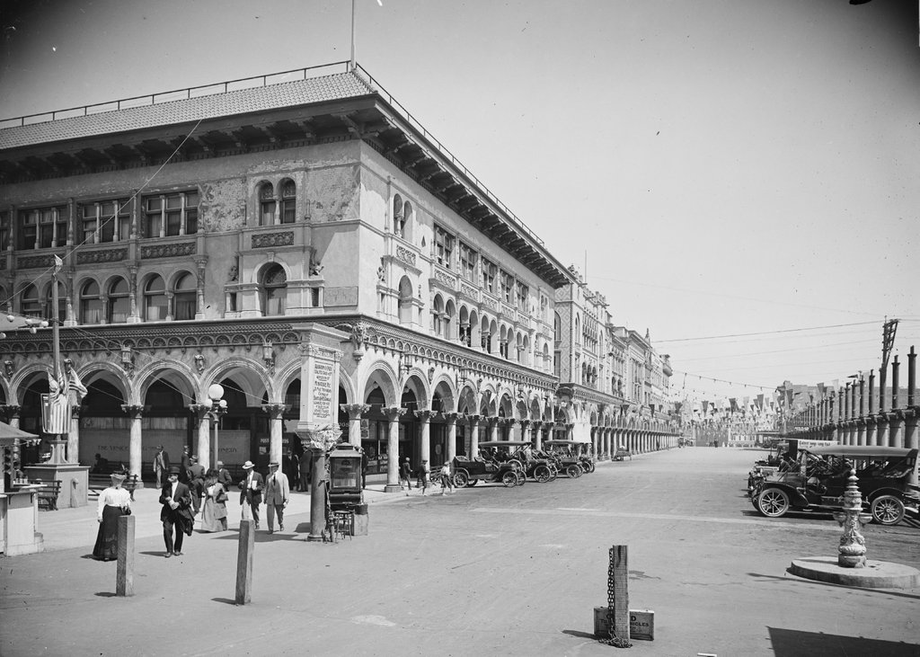
Looking east on Windward Avenue in Venice, around 1912. Image courtesy of the Library of Congress, Detroit Publishing Company Collection.
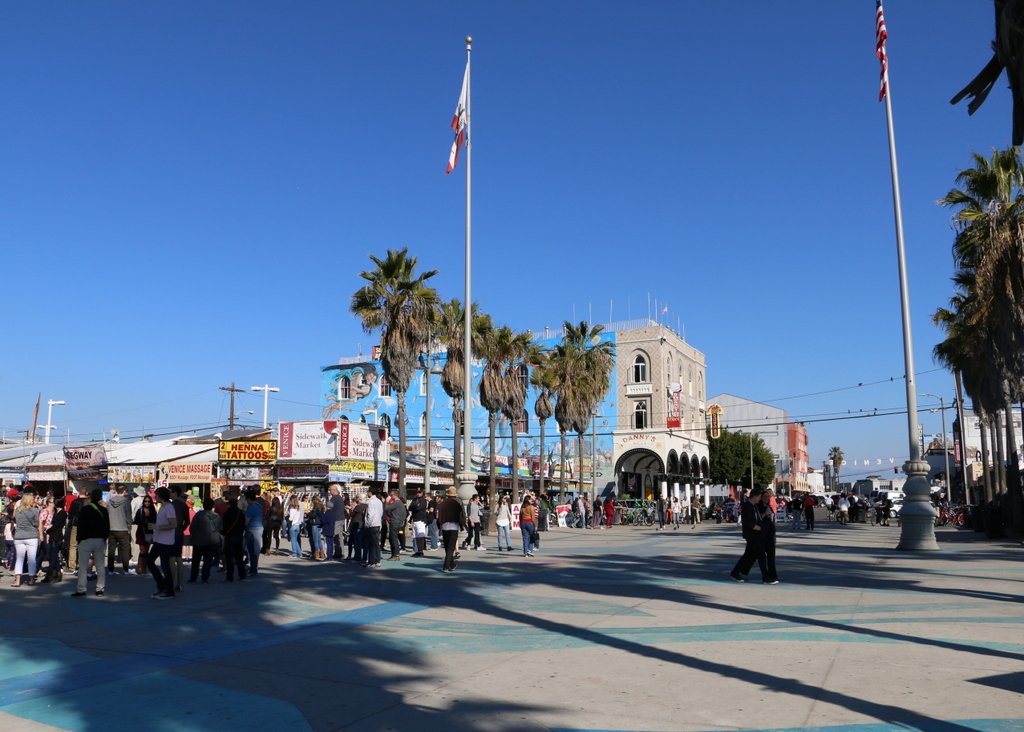
912_1900-1915 loc

The scene in 2015:

912_2015
Venice was founded in 1905 as a beach resort town just west of Los Angeles. Its developer, tobacco company owner Abbott Kinney, envisioned it as the “Venice of America,” complete with canals, gondolas, and Venetian-style architecture. Among the architectural features in the first photo are the arcades, or arches, along all of the buildings here on Windward Avenue. The building on the left at the corner is the Hotel St. Mark, which was built in 1905, and beyond it are a number of other matching buildings. On the right side, many of the buildings are not yet completed, with a row of columns marking where arches would eventually be built.

When the first photo was taken, Venice had already become a popular tourist destination. The white sign in front of the hotel advertises some of the city’s attractions, including the aquarium on the pier (admission 10 cents), the scenic railway, gondolas and boats on the canals, and the Venice Plunge, which was a heated indoor salt-water pool on one of the piers.

The city was successful in attracting tourists, but politically it was unable to support itself, so in 1926 the residents voted to be annexed by Los Angeles. This brought some major changes, which included filling in most of the canals and building roads on top of them. Venice’s decline continued during and after the Great Depression, and by the 1950s it was in serious decay. The piers were demolished by the 1960s, as were many of the historic buildings here along Windward Avenue and elsewhere in Venice.

Today, Venice is known for its unique countercultural aspects, including artists, street performers, and an inordinate number of medicinal marijuana dispensaries. A number of small shops now occupy the space where the Hotel St. Mark once stood, but a few of the buildings from the first photo still remain, including the one in the center of the photo and another further down Windward Avenue. Over the years, Venice has been used as a filming location for many movies and television shows, several of which feature this particular view here. The opening scene of Orson Welles’s 1958 film Touch of Evil shows the St. Mark a few years before its demolition, and a 2003 episode of Gilmore Girls includes several scenes from this section of Windward Avenue.

This post is part of a series of photos that I took in California this past winter. Click here to see the other posts in the “Lost New England Goes West” series.

Lost New England Goes West: James C. Flood Mansion, San Francisco

The James C. Flood Mansion on California Street in San Francisco, in the aftermath of the April 18, 1906 earthquake. Image courtesy of the Library of Congress, Detroit Publishing Company Collection.

881_1906c loc

The house in 2015:

881_2015
James C. Flood was born in New York City, but when he was in his early 20s he joined the California Gold Rush and moved to San Francisco in 1849. He had limited success in gold mining, but after a short time running the Auction Lunch Saloon, he began purchasing shares in silver mines and eventually made his fortune off of the Comstock Lode in Nevada. In 1886, he built this mansion on Nob Hill, where many of the city’s other millionaires lived at the time.

He only lived here for three years before his death in 1889, and at the time of the 1906 earthquake his daughter Cora lived here. Most of the other Nob Hill mansions were made of wood, so although the Flood Mansion was completely gutted by the fires, the stone exterior survived. The property was sold to the Pacific-Union Club, who rebuilt the interior and added wings to either side of the building and a third floor. Today, it is still used as their clubhouse, and along with the nearby Fairmont Hotel it is one of the few pre-earthquake buildings still standing on Nob Hill.

This post is part of a series of photos that I took in California this past winter. Click here to see the other posts in the “Lost New England Goes West” series.

Lost New England Goes West: Fairmont Hotel, San Francisco

The Fairmont San Francisco, seen from the corner of California and Powell Streets in the aftermath of the April 18, 1906 earthquake. Image courtesy of the Library of Congress, Detroit Publishing Company Collection.

880_1906c loc

The hotel in 2015:

880_2015
The Fairmont Hotel was still under construction when the 1906 earthquake hit. Structurally, it was heavily damaged, but it survived, and for a time was even used for emergency planning meetings before the fires made their way up Nob Hill. The burn stains over the windows in the first photo show the extent of the fire that gutted the hotel, but it would soon be repaired. The owners hired architect Julia Morgan to oversee the reconstruction, and the hotel opened exactly a year after the earthquake.

Nearly 40 years later, in 1945, it played a role in establishing the United Nations. While World War II was just coming to an end that summer, representatives from 50 countries met here at the hotel to draft the United Nations Charter, which was later signed at the San Francisco War Memorial and Performing Arts Center, and went into effect on October 26, 1945. Since then, it has remained a prominent San Francisco hotel, and it is listed on the National Register of Historic Places.

This post is part of a series of photos that I took in California this past winter. Click here to see the other posts in the “Lost New England Goes West” series.

Lost New England Goes West: California Street, San Francisco

The view looking up California Street from Sansome Street in San Francisco, in the aftermath of the April 18, 1906 earthquake. Image courtesy of the Library of Congress, Detroit Publishing Company Collection.

879_1906c loc

California Street in 2015:

879_2015
California Street is at the heart of San Francisco’s Financial District, and this area was hit hard by the 1906 earthquake and the subsequent fires. Most of the buildings in this scene appear to have been supported by load-bearing masonry walls, which easily crumbled as the ground shook. However, several taller buildings in this scene survived serious structural damage, including the 1904 Merchants Exchange Building in the left center, and the 1901 Kohl Building in the right center of the photo. These modern skyscrapers were built with steel frames, which have more “give” in an earthquake than brick or stone, allowing the building to bend rather than crack, and both are still standing today, amid newer and much taller skyscrapers.

The other surviving feature from this section of California Street is the cable car line, which is visible in the middle of the street in both photos. It was once one of 23 lines in the city, but after the earthquake most were replaced with less expensive electric trolleys. However, this line remained in operation because of its geography; Nob Hill in the distance was insurmountable for conventional trolleys, which did not have the traction to get up the steep grade. Cable cars, though, are literally pulled up the hill by a continuously-running cable under the street, which allows it to climb far steeper hills than the trolleys. Today, the city’s three remaining cable car lines are mostly used by tourists, but the California Street line still sees a significant number of commuters, because of its location in the Financial District.

This post is part of a series of photos that I took in California this past winter. Click here to see the other posts in the “Lost New England Goes West” series.