Rhode Island Normal School, Providence, RI

The Rhode Island Normal School, seen from Francis Street in Providence, around 1906. Image courtesy of the Library of Congress, Detroit Publishing Company Collection.

1059_1906c-loc

The scene in 2016:

1059_2016
The building in the first photo was once the home of the Rhode Island Normal School, a teacher preparatory college that has since become Rhode Island College. The school was established in 1854, and was housed in several different buildings in the city until 1898, when the building in the first photo opened. Here, it enjoyed a prominent location just south of the Rhode Island State House, with a large lawn on the Francis Street side of the building.

During its time here, the school steadily grew. In 1920, it became the Rhode Island College of Education, offering bachelor’s and master’s degrees for the first time. By the 1950s, though, there were talks of merging the school into the University of Rhode Island. However, the school remained independent, and in 1958 they moved to a new campus in the outskirts of the city. A year later, with the school expanding beyond just education degrees, the name was changed to simply Rhode Island College.

After the college moved to its current campus, the old 1898 building remained here in downtown Providence for many more years. It was finally demolished in the late 1990s to build Providence Place, the large shopping mall that stands on the site today. I don’t known whether it was deliberate or not, but the Nordstrom section of the building appears to pay homage to the design of the old Normal School, with its yellow brick exterior and the similar-looking cornice with dentils at the top of the building.

Rhode Island State House, Providence, RI

The south side of the Rhode Island State House in Providence, around 1906. Image courtesy of the Library of Congress, Detroit Publishing Company Collection.

1058_1906c-loc

The scene in 2016:

1058_2016
Rhode Island is known for having the smallest land area of any US state, but despite its diminutive size, it had an unusual state capital arrangement for many years, with the legislature alternating sessions between the five county courthouses, effectively giving the state five capital cities. While much larger states managed to make do with just one capital city, this practice continued until 1854, when the rotation was reduced to just two, Providence and Newport. Having joint capitals was not unique to Rhode Island – neighboring Connecticut did the same for many years – but Rhode Island continued the practice until 1900.

At this point, when the legislature was in Providence, they were still meeting in the small colonial-era courthouse on Benefit Street. It hardly compared to the far grander capitol buildings other New England states such as Connecticut and Massachusetts, so in 1895 construction began on the present-day Rhode Island State House. It was built on Smith Hill, a hill that overlooks downtown Providence on the other side of the Woonasquatucket River. Its architecture resembles the US Capitol Building, with wings on either side for the two legislative houses and a large rotunda in the center, and it was designed by the prominent firm of McKim, Mead and White in their distinctive Classical Revival style.

The Rhode Island legislature began meeting in the new building in 1901, although it was not completed until 1904, after nearly a decade of construction. Today, the area around the State House has seen some dramatic changes. Interstate 95 now passes just west of here, and just to the east is the Northeast Corridor, the busiest passenger rail line in the country. To the southwest is Providence Place, a large shopping mall with adjacent parking garages. However, here on the State House grounds, very little has changed. The grounds retain a park-like atmosphere, and the historic building itself is still the seat of Rhode Island’s state government.

View from Citadel Hill, Halifax, Nova Scotia

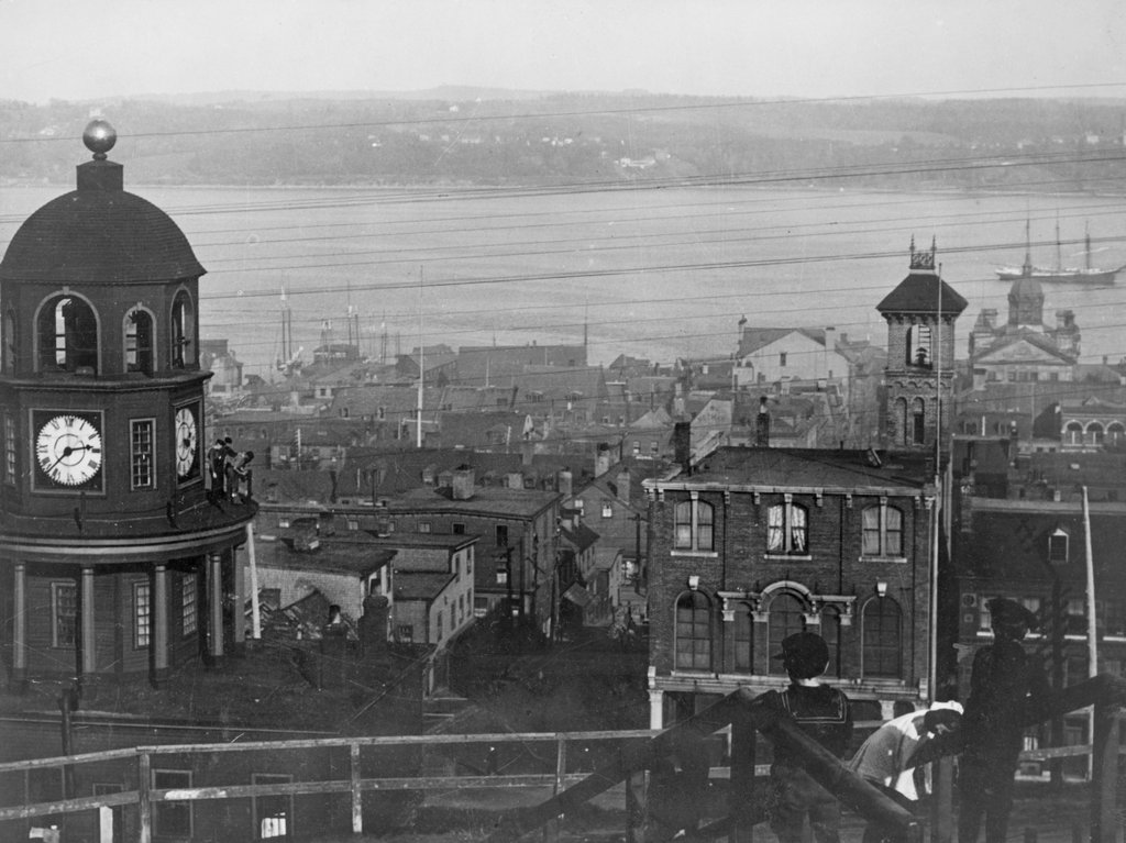
The view looking east toward downtown Halifax from Citadel Hill, around 1900-1917. Image courtesy of the Library of Congress.
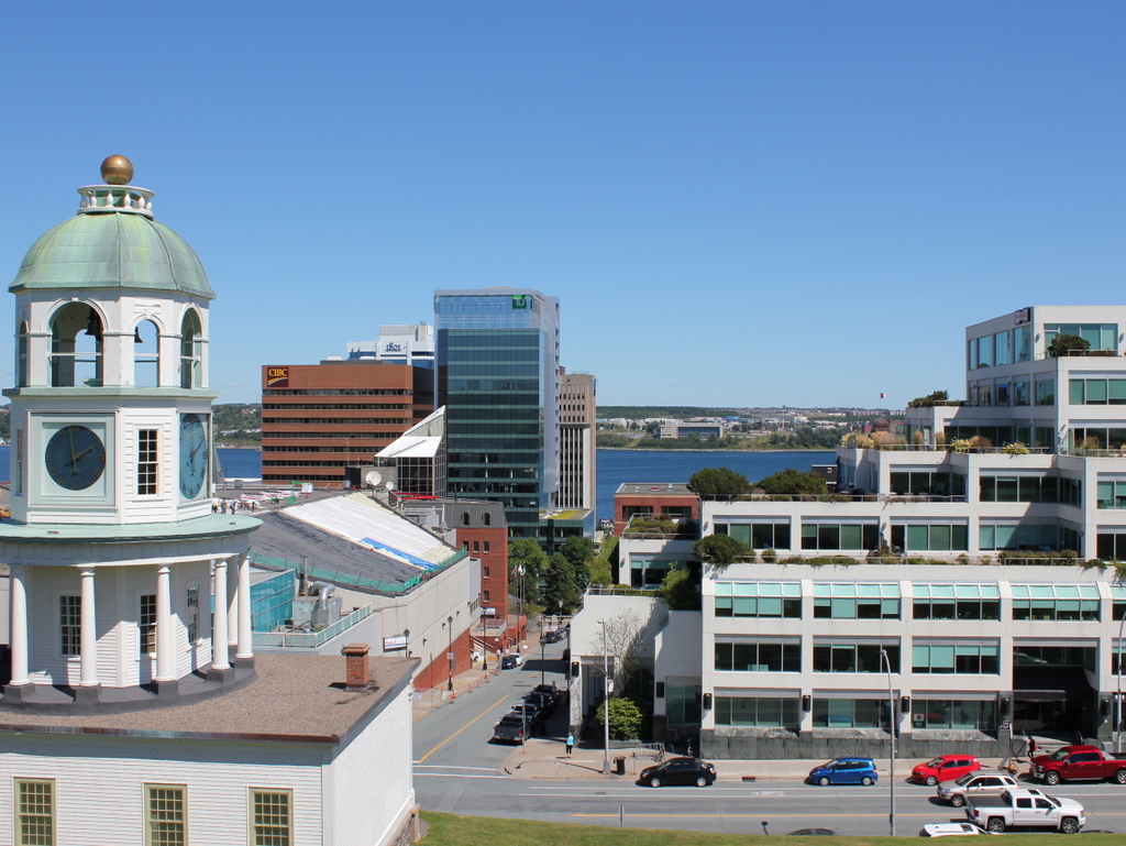
1056_1900-1917c-loc

The view in 2016:

1056_2016
It isn’t in New England, or even in the United States, but Halifax has long had close ties with New England, especially Boston. It is the closest major North American port to Europe, and as such it is the last stop for outgoing ships from Boston, and the first for incoming ships. This scene here shows part of the city’s massive harbor, which has been of strategic importance over the years. After the British occupation of Boston ended in 1776, their fleet took refuge here in Halifax while preparing for an assault on New York City, and many years later the harbor was used as a gathering place for eastbound Atlantic convoys in both world wars.

Through all of this, the strategically-valuable harbor has been protected by Fort George, a series of fortifications atop Citadel Hill. The hill stands just west of downtown Halifax, offering sweeping views of the city and harbor, and making it the ideal location for a fort to command the harbor and its approaches. The photos here were taken near the top of the hill, near the outer walls of the fort. On the left is one of Halifax’s oldest landmarks, the Town Clock, which was built at the foot of the hill. It faces down Carmichael Street, which leads to the Grand Parade three blocks down the hill, where City Hall and St. Paul’s Anglican Church are located.

The date of the first photo is somewhat unclear, but it was taken sometime soon before 1917, when Halifax experienced one of the deadliest disasters in history. Known as the Halifax Explosion, it occurred on December 6, 1917, when the harbor was filled with ships heading to and from Europe during World War I. Two such ships were the Norwegian SS Imo, which collided with French ammunition ship SS Mont-Blanc. The latter caught fire, and after about 20 minutes its cargo of high explosives detonated.

The Mont-Blanc was essentially vaporized, and the blast wave leveled much of the northern part of the city, to the left and out of view in the photos here. A few earlier posts, here and here, show scenes from the aftermath of the explosion, which killed nearly 2,000 people, injured around 9,000 others, and damaged or destroyed around 12,000 houses. The main commercial center of Halifax, seen in this view from Citadel Hill, escaped serious damage. Essentially every window in the city was shattered by the explosion, but most of the buildings in the first photo would have survived the disaster.

Despite being spared from serious damage, there is very little that is still recognizable from the first photo a century later. There are a number of 19th century buildings scattered throughout this section of the city, but the only one that is readily visible in both photos is the clock tower itself, which remains a prominent city landmark.

Today, Halifax remains an important port. It is the largest city in Canada’s Maritime provinces, and its downtown has been built up with skyscrapers, partially obscuring the view of the harbor from Citadel Hill. The shoreline across the harbor in Dartmouth has also changed dramatically in the past 100 years. In 1911, the community had a population of just over 5,000, but today it has over 67,000 people, and is a major suburb of Halifax as well as a commercial center in its own right.

Josiah Day House, West Springfield, Mass (3)

One more view of the Josiah Day House on Park Street in West Springfield, around 1908. Image courtesy of the Library of Congress, Detroit Publishing Company Collection.

1054_1908c-loc

The scene in 2016:

1054_2016
This view of the Josiah Day House is similar to the previous one, showing what it looked like around the time that the Ramapogue Historical Society acquired it as a museum in the first decade of the 20th century. Since then, the area around the house has changed, and West Springfield’s town common is no longer lined with the tall trees that appeared in the first photo. However, the Day House is still standing, and remains a museum, with an interior furnished with 18th and 19th century antiques, many of which belonged to the Day family, who lived in this house for four generations from 1754 to 1897. For more information on the history of the house, see this earlier post.

Josiah Day House, West Springfield, Mass (2)

Another photo of the Josiah Day House on Park Street in West Springfield, around 1900-1910. Image courtesy of the Library of Congress, Detroit Publishing Company Collection.

1053_1900-1910-loc

The house in 2016:

1053_2016
As mentioned in the previous post, the Josiah Day House is the oldest building in West Springfield, dating back to 1754. This angle of the house shows the wooden 1810 addition, which was built for Aaron Day, Jr. and his wife Anne. Aaron was the grandson of the home’s original owner, and he and Anne raised their six children here in the first half of the 19th century.

The last of their children, Lydia, died in 1897. She was the last of four consecutive generations of Days to live in the house, and in 1902 the family put the property up for sale. It was purchased by the Ramapogue Historical Society, who preserved it as a museum. Today, the house is on the National Register of Historic Places, and is one of West Springfield’s historic treasures. For more details on the history of this house, see the previous post.

Josiah Day House, West Springfield, Mass (1)

The Josiah Day House on Park Street in West Springfield, around 1900-1910. Image courtesy of the Library of Congress, Detroit Publishing Company Collection.

1052_1900-1910-loc

The house in 2016:

1052_2016
This house is the oldest existing building in West Springfield, and probably the oldest brick building in Hampden County. It was built by Josiah Day in 1754 as a rare example of a brick saltbox-style house, and is probably the oldest such house in the United States. The house actually predates West Springfield itself, which had been settled in 1660 as part of Springfield, but was not actually incorporated as a separate town until 1774. By this point, the village on the west side of the river, with its fertile soil for farming, had grown larger and more prosperous than Springfield itself, and for many years its residents had been calling for separation.

Josiah Day was one of the residents who had petitioned the colonial General Court of Massachusetts for separation from Springfield, but he never lived to see West Springfield become its own town. He died in 1770, and his son Aaron inherited the house. Aaron and his wife Eunice moved into the house after their marriage in 1775, just months before the start of the American Revolution.

Although far removed from any major battles, the Day house nonetheless saw several important events relating to the war. In January 1776, Henry Knox passed in front of the house along his journey from Fort Ticonderoga to Boston. He and his men were hauling 60 tons of cannons to fortify Dorchester Heights overlooking Boston, and just two months later these guns forced the British to evacuate Boston. Two years later, the Day House saw the results of another American victory in the war. Following the British defeat at Saratoga, General Riedesel and his Hessian troops were captured and marched to Boston, and along the way they stopped and encamped here in West Springfield on October 30 and 31, 1777, on the common in front of the house.

The closest that the Day House came to witnessing direct military action came nearly a decade later, during Shays’ Rebellion. This uprising, which took place in western Massachusetts in 1786-1787, was the result of high taxes and foreclosures against farmers in the region, and during this time the rebels succeeded in closing courthouses to prevent foreclosure cases from coming to trial. Although Daniel Shays of Pelham was the primary leader of the uprising, Luke Day of West Springfield was also one of the leaders. Luke and Aaron Day were second cousins, and while planning for the assault on the Springfield Arsenal, the climactic event of the rebellion, Luke trained his soldiers on the common in front of the house. According to local tradition, he also used his cousin’s house as his headquarters while he planned the attack.

In the meantime, Aaron and Eunice Day continued living in this house for decades. In 1810, they expanded the house with a wooden addition in the back for their oldest son, Aaron, Jr., who had married Anne Ely that year. Eunice died in 1818 and Aaron, Sr. in 1827, and the house was passed down to the younger Aaron. He and Anne raised their six children here, and Lydia, their last surviving child, lived in the house until her death in 1897. A few years later, the house was sold by the Day family after four consecutive generations of ownership.

While so many other colonial buildings in the area were being demolished around the turn of the 20th century, the Day House was purchased by the Ramapogue Historical Society, around the same time that the first photo was taken. This early effort at historic preservation has been successful, and today the house is still owned by the society. It is open to the public as a museum, and the interior is furnished with antiques from the 18th and 19th centuries, many of which had once belonged to members of the Day family.