Junction House, White River Junction, Vermont

The Junction House on South Main Street in White River Junction, around 1865-1878. Image courtesy of the New York Public Library.

The scene in 2018:

The village of White River Junction is located within the town of Hartford, Vermont, on the New Hampshire border at the confluence of the White River and Connecticut River. Hartford’s original town center is located about a mile to the west of here, along the banks of the White River, but by the second half of the 19th century much of the town’s commercial activity had shifted here to White River Junction, thanks in large part to the advent of rail travel.

The late 1840s saw a frenzy of railroad construction in Vermont, and this site became an important hub in the state’s rail network. By the end of the decade, four rail lines converged here, with the Vermont Central Railway from the northwest, the Connecticut River Railroad from the south, the Connecticut and Passumpsic Rivers Railroad from the north, and the Northern New Hampshire Railroad from the east. A fifth railroad, the short 14-mile Woodstock Railroad, subsequently opened to the west of here in 1875, connecting White River Junction to Woodstock, Vermont.

Prior to the construction of these rail lines, this part of Hartford was sparsely populated, with only a few farms and a one-room schoolhouse. One of these farmers was Samuel Nutt, who had lived here since 1817 and owned about 500 acres of land. The rail lines met right near his house, and he was quick to recognize the strategic location of this property. By 1849 he had purchased the Grafton House hotel in nearby Enfield, New Hampshire, dismantled it, and rebuilt it here in White River Junction, as shown in the first photo. It was named the Junction House, and it thrived on business from the railroads, providing both meals and overnight accommodations for travelers.

Throughout the 1850s, advertisements for the Junction House regularly appeared in local newspapers, promising “Meals in readiness on the arrival of each train of Cars” along with “Horses and Carriages to Let.” One newspaper, the Independent Democrat of Concord, New Hampshire, published glowing remarks about the hotel in 1852 while describing a short layover here at White River Junction:

Here, being informed that we had half an hour’s waiting to do for the up-river train, most of our company—ourself in particular—went over to the Junction House, situated a few rods from the Depot, where we found a well-set and well-furnished table, at which we replenished the inner man to our hearts’—perhaps we should say bowels’—content. The Junction House is a new, commodiously built house, kept by Mr. H. F. Willis, who understands himself and the wants of his guests.

Three years later, the Vermont Phoenix of Brattleboro provided similar praise:

The “Junction House” at White River Junction, is one of the neatest and best managed hotels we have ever visited in Vermont; and, what is of more consequence to the proprietor, it does a capital business. Being favorably located for public travel it receives and entertains the travellers of three trains which have their terminus nightly at the Junction. Col. Samuel Nutt is the popular landlord who does the honors of the house, and he is very efficiently assisted by Mr. Wm. H. Witt, formerly of this village. The journey to Montpelier is made exceedingly pleasant and convenient by stopping over night under such care and with such excellent keeping.

Along with serving travelers, though, the hotel was also a meeting place for locals. During the 1850s and 1860s it was used for a variety of events, including railroad shareholder meetings, agricultural society meetings, public auctions, and nominating conventions for political parties. Most of these political conventions were for local and congressional district races, but the 1856 Republican state convention was held here in White River Junction, in a tent near the hotel. The event drew over two thousand attendees, but not all approved of the location, with the Middlebury Register writing:

We regret to close by hoping that the people of this state will never be called again to White River Junction for a similar purpose. The location is absurdly inconvenient, and a good many complaints of petty extortion at the Junction House, have reached our ears. One dollar for a hard dinner, at a Mass Convention of plain farmers, is cutting it rather fat.

By this point, Samuel Nutt was no longer running the hotel. He sold it earlier in 1856 to C. S. Hambleton, who was evidently responsible for making the attendees pay a dollar for dinner. Although it seems trivial now, this was a substantial amount of money at the time, equivalent to nearly $30 today. This controversy aside, the hotel continued to prosper in the years that followed.

However, in 1863 the owner at the time, Asa T. Barron, faced some legal trouble, first when one of the boarders accused him of assault. He was ultimately absolved after it was discovered that the boarder had instigated the disturbance and Barron had acted out of self defense. Just a few months later, though, Barron faced more serious trouble when he sold liquor here despite the state’s strict prohibition laws. He was found guilty of 36 violations, for which he was fined $360.

Barron continued to run the Junction House throughout the 1860s and 1870s, and the first photo was almost certainly taken during his ownership. It shows the view from near the railroad depot, looking southwest across the tracks. The village was still only lightly developed at the time, and the photo shows a gravel bank on the side of the hill beyond the hotel. An 1869 map of the village shows only a handful of buildings along this section of South Main Street, and most of these appear to have been houses, with the exception of the Junction House and a nearby store that was operated out of a converted farmhouse.

The original Junction House stood here until 1878, when it was destroyed by a fire on the morning of August 10. The fire began in the kitchen, and it soon spread throughout the building. Without any local fire companies, it took about an hour for firemen and equipment to arrive by train from Hanover and Lebanon, New Hampshire. By this point, the hotel was beyond saving, but the firemen were able to prevent it from spreading to other nearby structures.

The fire caused an estimated $50,000 in damage to the property, only about half of which was insured. Apparently, not everyone saw the fire as a tragedy, though. Writing just over a decade later in History of Hartford, Vermont, July 4, 1761-April 4, 1889, author William Howard Tucker argued that “It was a den of wickedness and its destruction should have been regarded by the senior proprietor thereof as the natural sequence of the unrestricted looseness that characterized his system of running this public house.”

Such disapproval notwithstanding, the Junction House was soon rebuilt. The new building was completed in 1879, and it was about one and a half times larger than the old one, featuring room for about 200 guests and a hall that could seat about a thousand. It was four stories in height, and it had two towers, which were located on either end of the front facade. Asa Barron still owned the hotel at the time, but he sold the property within about a year of the completion of the new building.

The new Junction House remained an important hotel into the 20th century. It was eventually expanded to 340 rooms, and in 1925 it was renamed the Hotel Coolidge in honor of the owner’s close friend, John C. Coolidge, the father of then-President Calvin Coolidge. Many evidently assumed that it had been named for the president, and the Caledonian Record of St. Johnsbury humorously observed that the change was done “probably in the hope that it will be quieter at night,” in reference to Calvin Coolidge’s famously silent demeanor.

Only a few weeks later, though, the newly-renamed hotel also burned. This time, it was caused by an oil heater that exploded on the second floor. As with the fire nearly a half century earlier, crews from New Hampshire arrived to fight the flames, but the building was a total loss. The fire also destroyed eight stores on the ground floor, but all of the guests were safely evacuated from the hotel and there was no loss of life.

As before, the hotel was quickly rebuilt, and this time it had a brick facade. Its exterior lacked the ornamentation of the previous hotel, but it featured two towers that echoed those of its predecessor. This building has now stood here for longer than the two earlier ones combined, and it remains the Hotel Coolidge nearly a century after it was completed. During this time, it has even hosted its namesake president in May 1929, when Coolidge spent several days at the hotel while on a fishing trip, several months after leaving the White House.

Today, with the decline of rail travel, White River Junction is no longer the bustling railroad hub that it once was. The area is still at the juncture of two major transportation routes, with Interstates 89 and 91 crossing just to the west of here, but the highways bypass the village itself. However, many of the historic buildings in the center of White River Junction have survived over the years, including the Hotel Coolidge and the surrounding commercial buildings, such as the large 1890 Gates Block on the right side of this scene, and the c.1910 Greenough Block, located beyond the hotel on the left side. All of these buildings, along with a number of others in the area, are now part of the White River Junction Historic District, which was added to the National Register of Historic Places in 1980.

Old North Bridge, Concord, Mass (3)

Looking west across the Old North Bridge over the Concord River in Concord, around 1875-1885. Image courtesy of the New York Public Library.

The scene around 1900-1909. Image courtesy of the Library of Congress, Detroit Publishing Company Collection.

The scene in 2018:

As discussed in more detail in an earlier post, the Old North Bridge over the Concord River was the site of the Battle of Concord at the beginning of the American Revolution. It occurred on April 19, 1775, only a few hours after the opening shots of the war in nearby Lexington, and it was the first American victory of the war, resulting in the British abandoning their search for colonial munitions and returning to Boston.

Because of its historical significance, the battlefield is now marked with two monuments. On the east side of the river, directly behind the spot where this photo was taken, is a granite obelisk dedicated in 1837, and on the west side of the bridge is the statue The Minute Man, visible in the distance of all three photos. This statue was the work of prominent sculptor Daniel Chester French, and it was dedicated on the 100th anniversary of the battle on April 19, 1775, in a ceremony that included dignitaries such as President Ulysses S. Grant.

Aside from the monuments, the most significant landmark here on the battlefield is the bridge. The original one was removed in 1788, and from 1793 to 1875 there was no bridge on this site after the roads were rerouted. However, as part of the centennial celebrations of 1875, a new one was built around the same time that the statue was installed. This bridge, shown here in the first photo, bore no resemblance to the original one. It was designed by noted architect William R. Emerson, and it featured a rustic Victorian-style design, with cedar logs for railings and two half-arbors at the middle of the bridge.

The centennial bridge was ultimately destroyed in a storm in 1888, and it was replaced by a simpler yet sturdier wooden bridge, as shown in the second photo. It was similar to, although not identical to, the original bridge here at this spot, and it stood here until it too was destroyed in 1909. Its replacement, built later in 1909, lasted until 1955, when it sustained serious damage in a flood. The current bridge was completed the following year, and it was designed to be a replica of the original colonial-era bridge.

In 1975, this bridge became a focal point for the bicentennial celebrations here in Concord. As was the case a century earlier, the event included a visit from the president, with Gerald Ford speaking from a platform here at the eastern end of the bridge, which was located just out of view on the right side of the scene. Since then, very little has changed here. The battlefield has been well-maintained in its 1775 appearance, and today the site probably looks more like it did on the day of the battle than in either of the two earlier photos. Much of this is due to the efforts of the National Park Service, which has administered the battlefield since 1959, when the bridge and the surrounding area became a part of the Minute Man National Historical Park.

Willey House, Hart’s Location, New Hampshire (3)

The view looking north in Crawford Notch in the White Mountains, with the Willey House in the distance on the left, around the 1860s or 1870s. Image courtesy of the New York Public Library.

The scene in 2018:

These photos show the view looking north in Crawford Notch, a long, narrow valley through the heart of the White Mountains. For many years, it was the only east-west route through the mountain range, and since the late 18th century it has been a vital transportation corridor. As explained in more detail in an earlier post, the first road through the notch was opened in 1774, and over the years it was steadily improved, eventually becoming part of the Tenth New Hampshire Turnpike in 1806.

To serve these travelers in the midst of the northern New Hampshire wilderness, a series of inns were opened in and around the notch. The first building within the notch itself was a house that was constructed in 1793. Later known as the Willey House, it stood in the left-center of the first photo, where the peak of its gabled roof is barely visible beyond a much larger three-story hotel that was constructed in 1845.

The house served as both a residence and a small inn, and it had several different owners in the early 19th century before being acquired by Samuel Willey in 1825. It was an isolated location in the middle of the notch, several miles away from the nearest neighbor, but Willey moved here in the fall of 1825, along with his wife Polly and their five young children. He spent much of the fall improving the property and preparing it for the long, cold northern New England winter, and the result was a modest but comfortable place for travelers to stop for food, drink, or shelter.

As the Willeys would soon discover, though, the house’s location at the base of a steep cliff made it susceptible to landslides. One occurred in June 1826, and it narrowly missed the house. Then, two months later, another one occurred during a heavy rainstorm on the night of August 28. This time, the house was completely encircled by the debris, although the house itself survived unscathed thanks to a low ledge just above it, which split the flow into two channels.

Unfortunately, though, the Willey family attempted to flee the house in the midst of the storm, evidently fearing that the house would be destroyed. However, in the darkness they unknowingly ran directly into the path of the slide, and all seven were killed, along with two hired hands who lived here with them. Searchers subsequently found six of the bodies, some of them badly mangled, but three of the Willey children were never recovered.

The sudden deaths of nine people, more than half of whom were children under the age of 13, quickly gained national attention. This helped to spur tourism to the White Mountains, and over the next few years many curious visitors came to Crawford Notch to see the Willey House, the aftermath of the landslide, and the surrounding wilderness. The story also became the subject of a now-lost painting by noted artist Thomas Cole, and a short story, “The Ambitious Guest,” by Nathaniel Hawthorne.

By the mid-19th century, the area was a popular destination thanks in large part to the publicity generated by the Willey disaster, and there were many hotels in the vicinity of Crawford Notch. These included the Willey House itself, which had been purchased by Horace Fabyan in 1845. He constructed a new, much larger hotel building adjacent to the old house, and it can be seen on the left side of the first photo. Both buildings stood here until nearly the end of the 19th century, but they were ultimately destroyed by a fire in September 1899.

Today, the site of the house and hotel is now the visitor center and park headquarters for the Crawford Notch State Park. There is little evidence of the buildings that once stood here, although the location of the Willey House is now marked by a small stone monument. The road has also changed significantly since the first photo was taken some 150 years ago, and the narrow dirt path is now U.S. Route 302. Overall, the only thing from the first photo that has not changed is the surrounding landscape, which has been preserved as part of the state park. This includes the most prominent feature in both photos, the 2,804-foot Mount Willard, which dominates the background of the scene and marks the northern end of Crawford Notch.

Willey House, Hart’s Location, New Hampshire (2)

The Willey House in Crawford Notch, around 1872. Image courtesy of the New York Public Library.

The scene in 2018:

As discussed in more detail in the previous post, this building was constructed in 1793 in Crawford Notch, a long, narrow pass through the White Mountains of New Hampshire. At the time, it was the only building in the notch, and for the next few decades it was operated as a tavern, providing food, drink, and lodging to travelers along this important transportation route.

In the fall of 1825, Samuel Willey moved here with his wife Polly and their five children. The family lived in the house, and Samuel continued to run the tavern. The house proved to be in a precarious location, though; it was at the base of a steep cliff, and the site was vulnerable to landslides, as the Willey family learned in June 1826 when one such slide narrowly missed their home.

Undeterred by this threat, the Willey family decided to remain here, in an isolated location far from any other neighbors. Samuel Willey was apparently convinced that this was a once-in-a-lifetime event, but another landslide came just two months later, during a torrential downpour on the night of August 28. This time, the house sat directly in the path of the slide, and the family—which also included two hired men—evidently heard it coming and evacuated the building. However, in the darkness outside they were engulfed by the landslide, and all nine of them were killed. Ironically, though, the house itself survived the landslide with minimal damage; a low ridge just behind the house had divided the landslide into two streams, causing it to circle around either side of the house before rejoining in the front yard.

The sudden, unexpected death of a young family, combined with the harsh wilderness setting and the seemingly cruel twist of fate that saved the house, resulted in national attention for this tragedy. Within a matter of months, tourists were flocking here to see the site of the disaster for themselves, and this would only increase over the next few years. Up until this point, the White Mountains were largely seen as an obstacle to travel, but in the aftermath of this event the region began to be seen as a destination in itself.

The tragedy also became the subject of various works of art and literature. Prominent painter Thomas Cole made a visit to the site early in his career in 1828, and he subsequently painted a now-lost landscape of the scene. Another young, aspiring artist was Nathaniel Hawthorne, who came here a few years later and, in 1835, published a fictionalized account of it as a short story, titled “The Ambitious Guest.”

In 1845, Horace Fabyan purchased the property and built a three-story hotel directly to the left of the house. It had room for 50 guests, and it was one of many hotels that were constructed around this time to accommodate the influx of visitors to the region. The first photo was less than 30 years later, showing the house in the foreground with the hotel behind it to the left. The buildings would stand here until September 1899, when both were destroyed by a fire that was apparently caused by a defective chimney.

Today, this site is now the location of a visitor center and the park headquarters of the Crawford Notch State Park. However, the Willey tragedy has not been forgotten. The spot where the house once stood is now marked by a small stone monument in the lower center of the 2018 photo, and the 4,285-foot mountain behind the house has been named Mount Willey, in honor of the family.

Willey House, Hart’s Location, New Hampshire

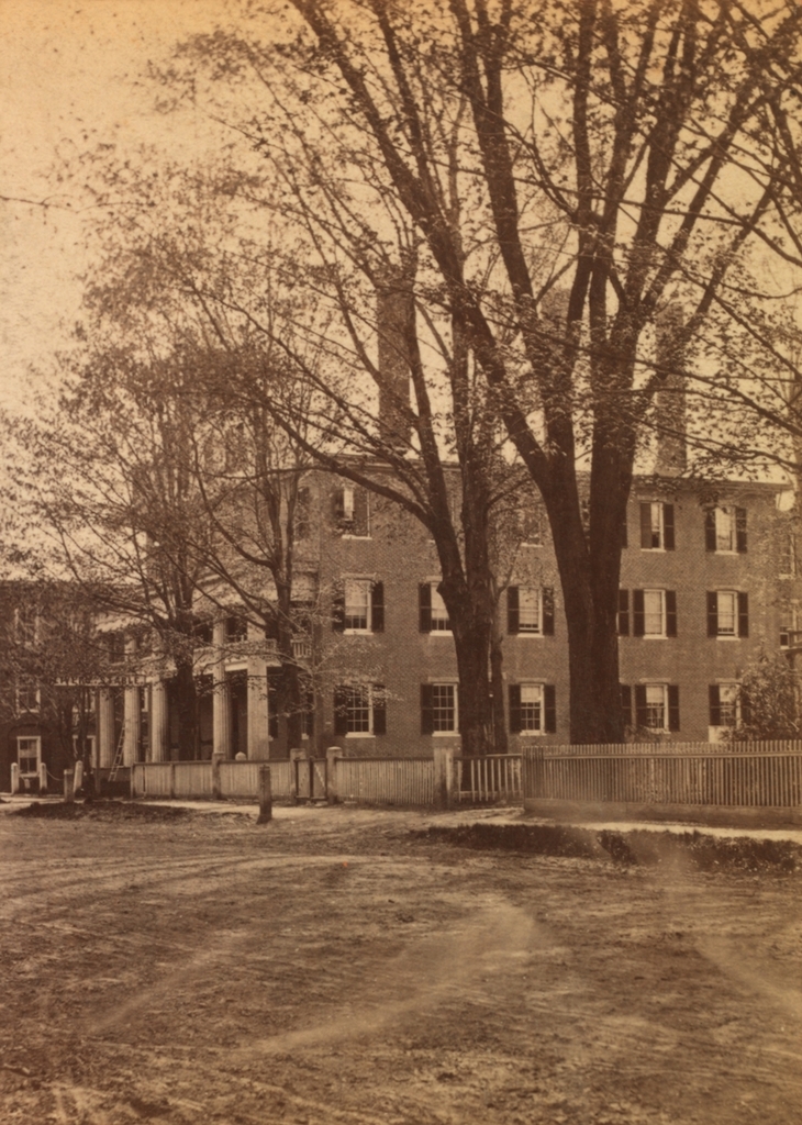
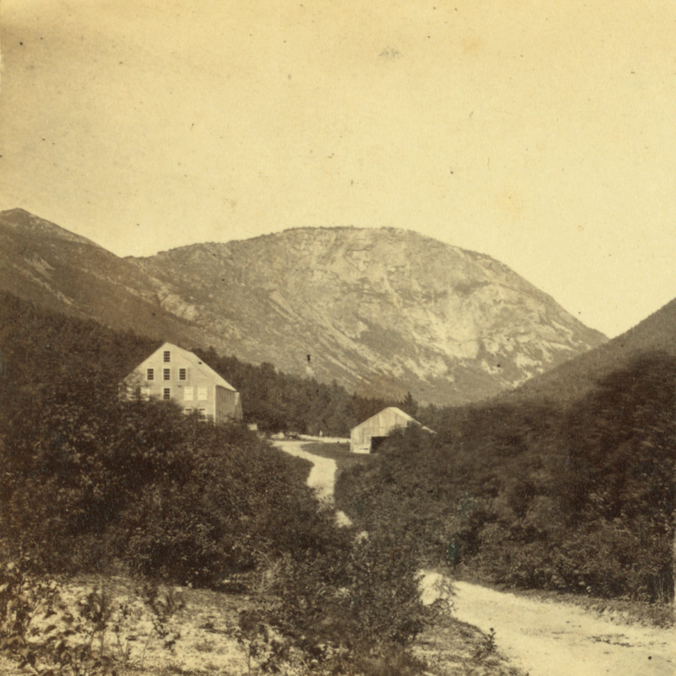
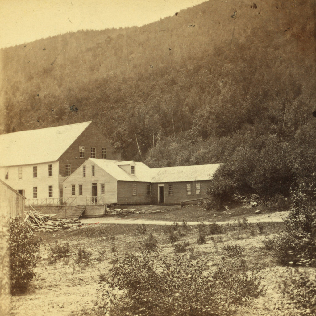
The Willey House in Crawford Notch, probably around the 1860s or 1870s. Image courtesy of the New York Public Library.
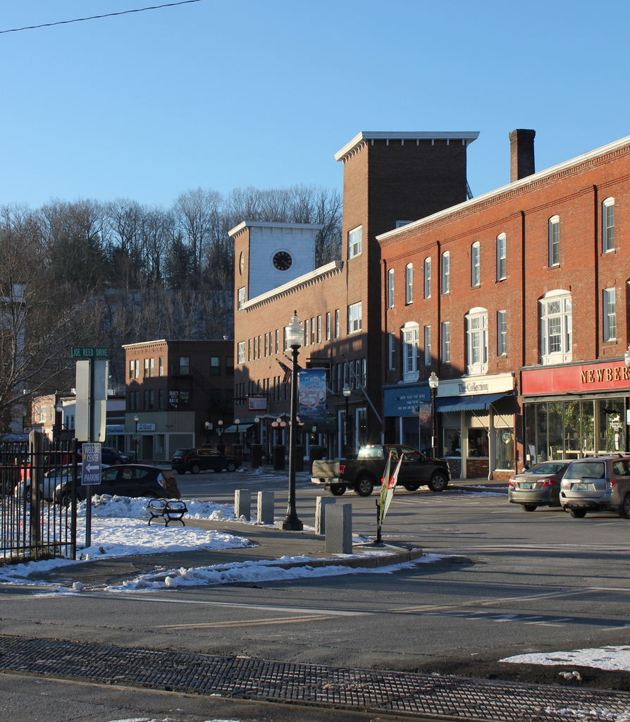
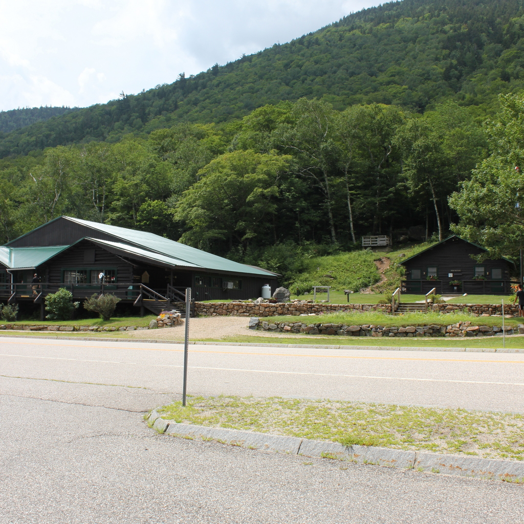
The scene in 2018:

The one-and-a-half-story building in the center of the first photo was built in 1793 in Crawford Notch, a long, narrow valley through the White Mountains of New Hampshire. The notch was, at the time, the only east-west route through the mountains, and this was evidently the first building to be constructed here. Known as the Notch House, it served as a tavern for travelers through here, and it was operated by several different innkeepers during the late 18th and early 19th centuries.

In the fall of 1825, the Notch House was acquired by Samuel Willey, who moved into the house with his wife Polly and their five children, who ranged in age from 2 to 11 years old. At the time, the property had been abandoned for several months, so Samuel spent much of the fall repairing the house, enlarging the stables, and making preparations for winter. The tavern was ready in time for the winter, and, despite its modest size and appearance, it was a welcome shelter for cold, weary travelers on their way through the mountains.

Willey continued to operate the tavern throughout the spring and summer of 1826, and a description of the house was published in the August 11 issue of the New Hampshire Sentinel newspaper. The writer, in describing a journey northbound through Crawford Notch, included the following account about the Notch House:

At the conclusion of this six miles, the eye is greeted with the appearance of a small but comfortable dwelling house, owned and occupied by a Mr. Willey, who has taken advantage of a small, a very small intervale, – where the bases of the two mountains seem to have paused and receded, as if afraid of coming in contact and amalgamating into one impassible pile, – to erect his lone habitation. Rude and uninviting as the spot appears, he has contrived to gather around it the necessaries if not conveniences of life. We observed a large flock of sheep in one of his inclosures; other domestic animals in the barn-yard, and several flocks of ducks and geese in the little meadow which fronted the house. We were furnished with a dinner of ham, eggs, and the usual accompaniments to such a meal in a country tavern. – The interior of the house exhibited a neatness that might well become some inns that we have seen of more frequent resort, and the faces of parents and children were the pictures of content. Can philosophy or conjecture account for or explain the motives that can induce a man thus to plant himself at a distance of six miles from the habitation of any of his race, and in a spot where it is next to impossible he can ever have a nearer neighbor?

Despite this bucolic description, though, there were more hazards to life here in Crawford Notch than simply its isolation. The house was situated at the base of a steep slope, on a narrow plot of flat ground between the mountain in the back, and the Saco River in front of the house on the other side of the road. As a result, this location was vulnerable to landslides, and its occupants would have no viable way to escape its path if one was to occur.

This reality became very clear to the Willey family in June 1826, when they survived a close call from one such landslide. The slide, which came within less than 200 feet of their house, covered about an acre of land by Samuel’s estimate, and it traveled nearly a mile in a matter of minutes. An account of this event was published in the New England Galaxy, and it subsequently appeared in The Farmers’ Cabinet on August 12, 1826, in an article that included the following description:

Just before our visit to this place, – on the 26th of June, – there was a tremendous avalanche, or slide, as it is there called, from the mountain which makes the southern wall of the passage. an immense mass of earth and rock from the side of the mountain was loosened from its resting place and began to slide towards the bottom. In its course it divided into three portions, each coming down with amazing velocity into the road, and sweeping before it shrubs, trees and rocks, and filling up the road beyond all possibility of its being recovered. 

The article went on the describe the Willey family’s reaction:

The place from which this slide or slip, was loosened, is directly in the rear of Mr. Willey’s house; and were there not a special Providence in the fall of a sparrow, and had not the fingers of that Providence traced the direction of the sliding mass, neither he nor any soul of his family would ever have told the tale. – They heard the noise when it first began to move, and ran to the door. In terror and amazement, they beheld the mountain in motion. But what can human power effect in such an emergency? Before they could think of retreating, or ascertain which way to escape, the danger was past.

According to Samuel’s brother Benjamin, who discussed the event in a book many years later, the Willeys had initially planned on moving away after this near-disaster, but upon further reflection they decided to stay. Benjamin related a conversation that Samuel had with another person after the incident, with Samuel supposedly explaining, “Such an event, we know, has not happened here for a very long time past, and another of the kind is not likely to occur for an equally long time to come. Taking things past in this view, then, I am not afraid.”

Over the next two months, the region experienced a severe drought that dried the soil to a much greater depth than usual. However, this drought came to a sudden end on the night of August 28, when a severe storm passed through here. The torrential rainfall destroyed nearly all of the bridges in the notch, and it also soaked deep into the dry earth, making the ground particularly susceptible to landslides along the steep cliffs. One such slide occurred here at the Notch House, but, as in the June slide, the building was narrowly spared. It stood right in the path of the landslide, but the falling debris struck a low ridge just above the house, causing it to split into two streams. As a result, the landslide passed on both sides of the house, destroying the stables but otherwise leaving the building miraculously intact before reuniting into a single stream just below the house.

Over the next few days, though, the nearby residents of the notch could find no sign of the seven members of the Willey family, or the two hired men who lived here. Inside the house, there was evidence that the occupants had left in a hurry, suggesting that they had tried to flee to safety in advance of the landslide. Subsequent searches of the area uncovered the badly-mangled bodies of Polly Willey and one of the hired men, David Allen, in the debris below the house. Samuel’s remains were soon discovered as well, along with those of their youngest child, three-year-old Sally. The body of David Nicholson, the other hired man, was found five days after the disaster, and a day later the body of twelve-year-old Eliza Willey was found far from the house, on the other side of the Saco River. However, the other three children—eleven-year-old Jeremiah, nine-year-old Martha, and seven-year-old Elbridge—were never found.

In the aftermath of the disaster, there were many theories as to exactly what happened here on the night of August 28. The most likely explanation, which Benjamin Willey provided in his book, is that Samuel stayed up during the night to monitor the storm and watch for signs of a landslide. As he heard the slide approaching, he awakened his family, and as they were leaving they heard the sound of the stables being destroyed. This caused them to flee in the opposite direction, and in the darkness and pouring rain they unknowingly ran directly into the path of the other side of the landslide.

Regardless of the actual sequence of events, though, the news of the disaster quickly spread across the country. Within just a few months, curious sightseers were making their way up to Crawford Notch to see the house and the devastation caused by the landslide, and over the next few years many more continued to arrive. This helped to fuel a nascent tourist industry here in the White Mountains. At the time, the eastern United States was becoming increasingly industrial and urbanized, and many were drawn by the primeval wilderness of the area and the destructive forces of nature that were demonstrated in the Willey disaster. Local innkeeper Ethan Allen Crawford—for whose family the notch is named—enjoyed brisk business in the aftermath of the tragedy, and in 1828 he constructed a new hotel a few miles away from here at the gates of the notch. Even Samuel’s brother, Benjamin Willey, capitalized on the influx of tourism by charging visitors for a guided tour of the house.

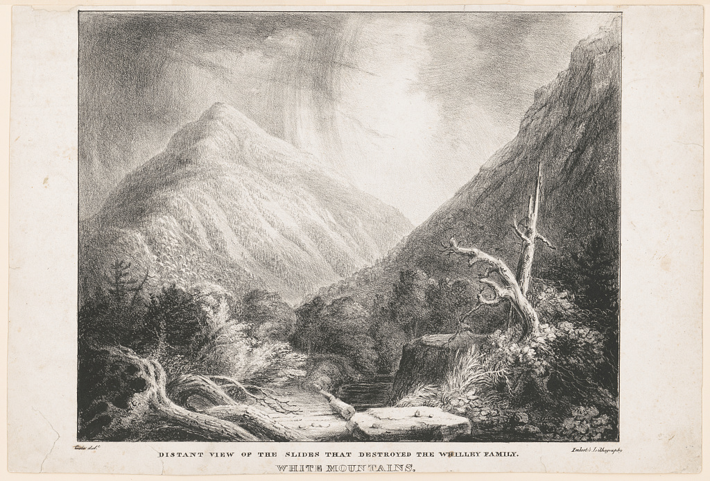
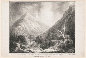
The tragedy also inspired noted artists and writers. Painter Thomas Cole visited here in October 1828, and he described how “[t]he sight of the Willey House, with its little patch of green in the gloomy desolation, very naturally recalled to mind the horrors of the night when the whole family perished beneath an avalanche of ricks and earth.” Cole was the founder of the Hudson River School art movement, and his paintings typically featured dramatic landscapes that emphasized both the beauty and the dangers of the untamed American wilderness. This setting in Crawford Notch, combined with the Willey disaster, was perfect subject matter for Cole, and he subsequently painted this scene. The painting, titled Distant View of the Slides that Destroyed the Whilley [sic] Family, is now lost, but there are several surviving lithographic reproductions, including the one below, which is located at the Library of Congress.

In addition to Cole, author Nathaniel Hawthorne also incorporated the disaster into one of his works. In 1835, when he was still a young, relatively obscure author, he published the short story “The Ambitious Guest,” which was based on the event. The story does not mention the Willey family by name, and there are some differences in the ages and composition of the family, but otherwise it is largely a retelling of the commonly-accepted theory about the Willey family’s demise. However, Hawthorne embellishes it by adding a character—the eponymous ambitious guest—who arrived at the house on the night of the storm. In the story, the young man talks with the family about his desire to leave a legacy so that he will be remembered after death. In the end, though, he dies along with the rest of the family, his body is never found, and there is uncertainty among the locals as to whether or not there had even been a guest in the house at the time.

In the meantime, the Willey House continued to be a popular attraction. By the mid-19th century, the White Mountains had become a major tourist destination, thanks in large part to the publicity surrounding the Willey disaster. A number of new hotels were constructed around this time, including one right here at the Willey House. In 1845, local hotelier Horace Fabyan purchased the property and constructed a new hotel directly adjacent to the old house, as shown on the left side of the first photo. It was named the Willey Hotel, and it stood three stories in height and measured 40 feet by 70 feet, with a capacity of 50 people.

The hotel and house were still standing here when the first photo was taken around the 1860s or 1870s. By this point, some 40 to 50 years after the disaster, there was little visual evidence of the destructive landslide, but the house remained an important local landmark. It survived for several more decades, but ultimately met the same fate as so many other White Mountain hotels when it was destroyed by a fire in September 1899, evidently as a result of a defective chimney.

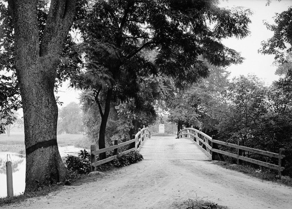
Today, more than 120 years after the fire, the house is long gone, but the story remains an important part of local lore. The site of the house is now marked by a small stone monument in the center of the first photo, and immediately to the left of it is a visitor center and the park headquarters of the Crawford Notch State Park. Further in the distance, the only landmark left from the first photo is the mountain itself, which looms more than 2,000 feet above the floor of the valley. At 4,285 feet in elevation, it is the 29th-tallest mountain in the state, and it is, appropriately enough, named Mount Willey.

Crawford Notch, Hart’s Location, New Hampshire

The view looking northwest through Crawford Notch in the White Mountains of New Hampshire, around 1860-1875. Image courtesy of the New York Public Library.

The same view around 1907. Image courtesy of the Library of Congress, Detroit Publishing Company Collection.

The scene in 2018:

Crawford Notch is an important mountain pass within the White Mountains of New Hampshire. Until the completion of the Kancamagus Highway in the 1960s, it was the only east-west route through the mountain range, and over the years it has served as a major link between northern Vermont and the coastal region of southern Maine. The notch consists of a narrow valley that is several miles in length, but the actual mountain pass is here at the northern end of this valley, at a gap in the mountains that was originally barely 20 feet wide. This spot came to be known as the gate of the notch, because of the high rocks that stand on either side of the pass.

The highest point of Crawford Notch is just to the north beyond the gates, in the distance of this scene. At 1,900 feet in elevation, it forms the divide between the Ammonoosuc River, which flows west to the Connecticut River and then to Long Island Sound, and the Saco River, which flows east through Crawford Notch and then to Maine, where it empties into the Atlantic Ocean just south of Portland. To the northeast of here is the Presidential Range, which begins here at the Notch and reaches its highest point, Mount Washington, about 6.5 miles from here. In the opposite direction, to the southwest of the notch, is the Peimgewasset Wilderness, the largest wilderness area in the state.

The first recorded discovery of Crawford Notch occurred in 1771, when Timothy Nash and Benjamin Sawyer came across it while hunting. As the story goes, Nash had become lost while tracking a moose. He climbed a tree in order to get his bearings, and in the process he sighted the gates here at the northern end of the notch. The notch had long been known to Native Americans, but Nash and Sawyer were evidently the first Europeans to find it, and within a few years there was a rough road through here.

The notch was ultimately named in honor of the Crawford family, who became the first permanent settlers of the area. Around 1790, Abel Crawford built a house a little further to the north of here, where he remained for several years before selling it to his father-in-law, Eleazer Rosebrook. Crawford then moved to the southern end of the notch, around the site of the present-day town of Hart’s Location.

Both he and Rosebrook operated inns for travelers, and Crawford helped to pioneer tourism to the White Mountains region. After Rosebrook’s death in 1817, Abel’s son Ethan Allen Crawford inherited the property here at the notch. Two years later, the Crawfords constructed an 8.5-mile trail from the notch to the summit of Mount Washington, and provided guided trips for visitors. Now known as the Crawford Path, it is considered to be the oldest continuously-used hiking trail in the country, and it has been incorporated into the Appalachian Trail.

One early visitor to this region was Timothy Dwight IV, a prominent author and theologian who served as president of Yale from 1795 to 1817. He came to the Notch on at least two separate occasions, and provided a description of it in his book Travels in New England and New York. In this particular visit, he approached the notch from the north, facing the opposite direction of these photos, and he wrote:

The entrance of the chasm is formed by two rocks, standing perpendicularly at the distance of twenty-two feet from each other: one about twenty feet in height, the other about twelve. Half of the space is occupied by the brook, mentioned as the head stream of the Saco; the other half by the road. The stream is lost, and invisible, beneath a mass of fragments, partly blown out of the road, and partly thrown down by some great convulsion.

When we entered the Notch we were struck with the wild and solemn appearance of every thing before us. The scale, on which all objects in view were formed, was the scale of grandeur only. The rocks, rude and ragged in a manner rarely paralleled, were fashioned and piled on each other by a hand, operating only in the boldest and most irregular manner. As we advanced, these appearances increased rapidly. Huge masses of granite, of every abrupt form, and hoary with a moss which seemed a product of ages, recalling to the mind the “Saxum vetustum” of Virgil, speedily rose to a mountainous height. Before us, the view widened fast to the south-east. Behind us, it closed almost instantaneously; and presented nothing to the eye but an impassable barrier of mountains.

The first photo was taken more than a half century after Dwight wrote this account, but the notch still had much of the same rugged appearance that he would have seen. The road had been improved somewhat over the years, starting in 1806, when the Tenth New Hampshire Turnpike opened through the notch. By the late 1820s, the road was suitable for stagecoaches, but when the first photo was taken around the 1860s or 1870s, this section of the road still looked like a narrow dirt path through the wilderness.

Aside from the road, the only sign of civilization in the first photo is the Crawford House, which is barely visible in the distant center. The original Crawford House was built here in the early 1850s, but it burned in 1859. The hotel was quickly rebuilt on the same site, reopening later in 1859. This new building can be seen in both the first and second photos, and it stood here until it too was destroyed by a fire in 1977. The site of the hotel is now the Highland Center, a lodge and education center operated by the Appalachian Mountain Club.

Perhaps the most dramatic change in this scene occurred shortly after the first photo was taken, when a railroad was constructed through here. The first railroad across the continent had been completed in 1869, and by this point there was even a cog railway to the summit of nearby Mount Washington. However, it would take several more years for railroad engineers to conquer Crawford Notch. The project required several long trestles and deep rock cuts, along with the widening of the gap here at the gates of the notch. The grade of the railroad was also a challenge, with northbound trains having to ascend 1,623 feet in just 30 miles, but the Portland & Ogdensburg Railroad was ultimately completed through the notch in 1875.

In addition to improving transportation through northern New England, the railroad also provided passenger service to the heart of the White Mountains, making it easier for tourists to visit the region. Several of the grand hotels along the route even had their own stations, including the Crawford House, whose station is barely visible in the distance on the right side of the tracks in the second photo. This particular station building had been constructed in 1891, several years after the Maine Central Railroad acquired the Portland & Ogdensburg, and it is still standing today as the only surviving structure from the second photo.

In more than a century since the second photo was taken, the road through the notch has been widened and straightened. It has come a long way since the dirt path of the first photo, and it is now designated as U.S. Route 302, which runs from Portland, Maine to Montpelier, Vermont. Today, it remains as important a route through the White Mountains as it had been when the first road was constructed through here in the 18th century. In that sense, the road has actually outlived the railroad, which was abandoned by Maine Central’s successors, Guilford Transportation, in 1983. However, this section of railroad was ultimately acquired by the Conway Scenic Railroad, which operates excursion trains for tourists. The railroad also owns the station here in the distance, and it serves as the northern terminus for most of its trains.

Today, the White Mountains are still a popular tourist destination, and Crawford Notch is still a major focal point within the region. Most of the notch is within the town of Hart’s Location (population 41 as of 2010), but the northern border of the town is here at the gates of the notch, so the buildings in the distance are actually within the town of Carroll. The land on the Carroll side of the border is still privately owned, but the Hart’s Location side is part of the 5,775-acre Crawford Notch State Park. This park is, in turn, mostly surrounded by the much larger White Mountains National Forest, which covers more than 750,000 acres in New Hampshire and Maine.