
Workers outside of the Berkshire Cotton Manufacturing Company, facing east on Hoosac Street at the corner of Depot Street in Adams, in August 1911. Image taken by Lewis Wickes Hine, courtesy of the Library of Congress, National Child Labor Committee Collection.

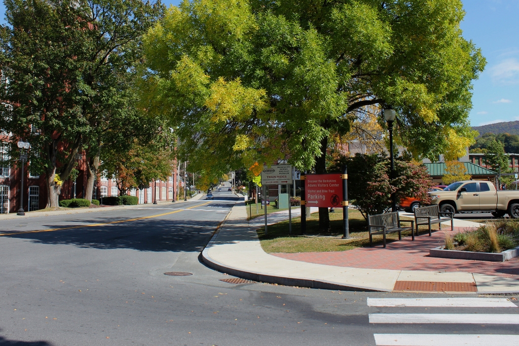
The scene in 2020:
The first photo was taken in August 1911 by prominent photojournalist and social reformer Lewis Wickes Hine. In the early 20th century, Hine traveled across the country on behalf of the National Child Labor Committee, taking thousands of photos that documented and exposed child labor conditions in factories, mines, farms, and other workplaces. He made several trips to New England during this time, including a lengthy visit in the summer and fall of 1911, when he investigated the region’s prosperous textile industry. Among his stops was the town of Adams in the northwestern corner of the state, where the Berkshire Cotton Manufacturing Company had a large factory complex along the Hoosac River. This photo shows the view looking down Hoosac Street toward the river, with Mill No. 1 in the distance on the left and the corner of Mill No. 3 in the foreground on the right side.
The Berkshire Cotton Manufacturing Company was established in 1889 by the prominent Plunkett family. The family patriarch, William C. Plunkett, had owned several local cotton mills in the mid-19th century, and he also served for two years as the state’s lieutenant governor in 1854 and 1855. He died in 1884, and five years later two of his sons, William and Charles Plunkett, organized the Berkshire Cotton Manufacturing Company. They built a new mill, which became Mill No. 1 here on the left side of the scene. The building featured some 35,000 spindles and 700 looms, but the company quickly outgrew this facility. Just two years later, the company began construction of a second mill directly behind this one, which more than doubled the number of spindles and looms.
The second mill was completed in 1892, and it was dedicated in a ceremony that included a speech by William McKinley, who was then serving as governor of Ohio. McKinley was a close friend of the Plunkett family, who supported his platform of high tariffs to protect American manufacturers. He would later return to Adams several times as president, including in 1897, when he spent the night at William Plunkett’s house and then toured the factory buildings the next day. By this point, the facility had been further expanded with the completion of Mill No. 3, which was built in 1896 on the opposite side of Hoosac Street, as shown in the foreground of the first photo. The company would make one more major addition in 1899, with Mill No. 4, located beyond Mill No. 3 on the other side of the railroad tracks. President McKinley was again on hand for this project, and he laid the cornerstone of the building in June 1899.
McKinley was ultimately assassinated in 1901, but he was commemorated here in Adams with a large statue just around the corner from here, at the intersection of Maple and Park Streets. In the meantime, the Berkshire Cotton Manufacturing Company continued to prosper, thanks in large part to the protective tariffs that McKinley had championed as a congressman and as president. By the turn of the 20th century, the company employed over two thousand workers, representing about half of the town’s entire workforce. The October 1908 issue of the trade journal Textile American included an article about the company, which described the facility as “the largest plant manufacturing fine goods at this time.” These fine goods, according to the article, included “carded and combed cotton goods, comprising lawns, organdies, mulls, India linens, etc.”
The first photo was taken only a few years later, and it was one of at least 25 photographs that Hine took during his visit. Most feature interior scenes of the factory, showing teenagers working as spinners and spooler tenders, among other jobs. He identified the ages of most of these workers, who were typically between 14 and 16 years old. This particular photo was one of the few exterior views that he captured, showing a group of workers gathered around the entrance. He does not provide any ages, but most of the employees appear to be adults, with the exception of the child in the center of the scene. Regarding this child, Hine wrote in his caption:
While I was photographing these workers (Berkshire Mills) the watchman dragged out the smallest boy, saying, “Here, photograph ‘Peewee'” Location: Adams, Massachusetts.
“Peewee” appears in one of Hine’s other photos, were he is sitting on the curb outside one of the factory buildings. Neither caption identifies his name or age, which is somewhat unusual for Hine, who typically provided at least one of these pieces of information about his subjects. However, his appearance is characteristic of many of Hines’s subjects, particularly his small size and his lack of shoes. This is further emphasized here in this photo by contrasting the boy with the otherwise well-shod and relatively well-dressed adults who are gathered around him, laughing and smiling.
It is unlikely that any of the workers in the 1911 photo would have realized it, but by this point the textile industry in New England was nearing its peak, and within the next few decades it would face a steep decline. Much of this was brought on by competition from the southern states, in addition to overseas competition that McKinley and his tariffs had sought to stave off. Many textile companies closed in the 1920s, and those that survived were typically hit hard by the Great Depression of the 1930s.
Berkshire Cotton Manufacturing Company lasted longer than most here in New England, and in 1929 it merged with four other textile companies to form the Berkshire Fine Spinning Associates. In consolidating, the company hoped to be in a better position to compete with southern manufacturers, and over the next few decades it continued to acquire other mills. Most significantly, in 1955 it merged with Hathaway Manufacturing Company of New Bedford, forming Berkshire Hathaway Inc.
Despite these many mergers, though, the textile industry in New England was in an irreversible decline. Berkshire Hathaway produced textiles here in Adams for only a few more years, before ultimately closing these mills in 1958, leaving some 1,200 workers unemployed. The company closed many of its other facilities around this time, before ultimately being acquired by a young Warren Buffett in 1965. Under his ownership, the company steadily moved away from textile manufacturing and into the realm of insurance and finance, eventually becoming the modern-day holding company headquartered in Omaha, Nebraska.
In the meantime, the old Berkshire mills here in Adams were sold off to other owners. Mill No. 2 was demolished in the early 1960s to build a supermarket on the lot, and Mill No. 3 was demolished about a decade later. As shown in the present-day scene, the site of this mill is now a surface parking lot. However, Mill No. 1 is still standing today, partially hidden by trees on the left side, as is Mill No. 4, which stands further in the distance in the right-center of the photo. Mill No. 4 is currently vacant, but No. 1 was repurposed as an apartment building in 1987. Despite these many changes, the building’s exterior has remained well-preserved over the years, and in 1982 it was added to the National Register of Historic Places.


