High Street from Main Street, Brattleboro, Vermont

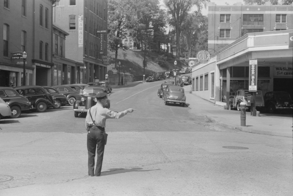
Looking west up High Street, from the corner of Main Street in Brattleboro, in August 1941. Image taken by Jack Delano, courtesy of the Library of Congress, Farm Security Administration/Office of War Information Collection.
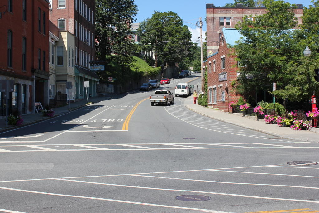
The scene in 2017:

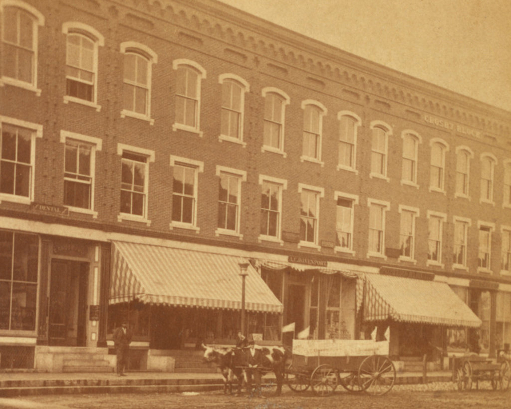
The first photo was taken in August 1941 by Jack Delano, a noted photographer who worked for the Farm Security Administration. This Depression-era agency was part of the New Deal, and its programs included photographers who traveled around the country, documenting rural poverty in the wake of the Great Depression. Delano visited Vermont in 1941, and he took a number of photographs here in Brattleboro, capturing images of everyday life in the town, including this scene of a police officer directing traffic at the corner of Main and High Streets.

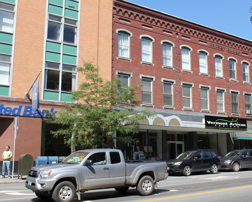
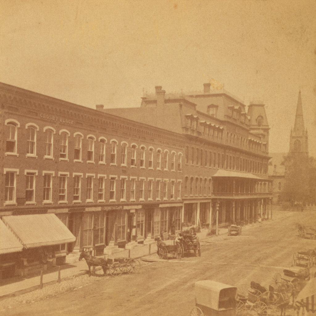
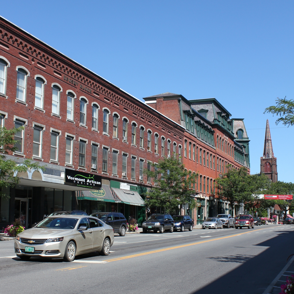
More than 75 years after the first photo was taken, this scene has not changed significantly. On the far left is the Brooks House, a hotel that was built in 1871 and converted into apartments and offices a century later. Next to it is the small, wood-frame Retting Block, which was built around 1850 and is probably the oldest building in this scene. Just beyond it is the much larger Manley Brothers Block, which was built around 1910, and on the other side of the street is the Manley Apartment Building, which was built about eight years later. Probably the newest building in the first photo was the Gulf station on the far right, at the corner of Main Street. It was later replaced by a Dunkin Donuts, which was, in turn, demolished to create Pliny Park, which now occupies the space.

Crosby Block, Brattleboro, Vermont

The Crosby Block on Main Street, just north of the corner of Elliot Street in Brattleboro, around 1871-1885. Image courtesy of the New York Public Library.

The scene in 2017:

As mentioned in the previous post, the Crosby Block was built in 1871, replacing several earlier commercial buildings that had been destroyed in a large fire two years before. It was owned by grain and flour merchant Edward Crosby, who built it at a cost of almost $175,000, or around $3.6 million today. Its Italianate-style design was the work of local architect George A. Hines, and it was originally 26 window bays in width, extending along Main Street from the corner of Elliot Street north to the Brooks House. Upon completion, the ground floor of the building housed a variety of stores, while the second floor had professional offices and the third floor had apartments.

Nearly 150 years after it was built, most of the Crosby Block has seen little change. However, the southernmost section of the building – once the home of Vermont National Bank – was rebuilt in the late 1950s, with an International Style yellow brick and metal facade. Now occupied by People’s United Bank, this section is still standing on the left side of the scene, and sharply contrasts with the surviving three quarters of the Crosby Block. The rest of the building, particularly the upper floors, has remained well-preserved, though. Today, it is one of the many historic 19th century commercial buildings that still line Main Street, and it is a contributing property in the Brattleboro Downtown Historic District, which was added to the National Register of Historic Places in 1983.

Crosby Block and Brooks House, Brattleboro, Vermont

Looking north on Main Street, from near the corner of Elliot Street in Brattleboro, around 1871-1885. Image courtesy of the New York Public Library.

The scene in 2017:

This block, on the west side of Main Street between Elliot and High Streets, was the scene of one of the most disastrous fires in Brattleboro history, which occurred on October 31, 1869. All of the buildings along this section of Main Street, mostly wood-frame stores and hotels, were destroyed in the fire, including the Brattleboro House hotel and several other important commercial blocks. However, the property was quickly redeveloped, and within two years the ruins had been replaced by two large, brick commercial buildings, with the Crosby Block on the left and the Brooks House further in the distance on the right.

The first photo shows the Crosby Block as it appeared within about 15 years of its completion in 1871. It was owned by grain and flour merchant Edward Crosby, and was designed by local architect George A. Hines, whose plans reflected the prevailing Italianate style for commercial buildings of this era. Only about two thirds of the building is visible in this scene, as it was once 26 window bays wide, extending all the way to the corner of Elliot Street. As was often the case in downtown commercial blocks, it was originally a mixed-use building, with stores on the ground floor, professional offices on the second floor, and apartments on the third floor.

Further in the distance, on the right side of the scene, is the Brooks House, which was also known as the Hotel Brooks. Although completed in the same year as the Crosby Block, it featured far more elaborate Second Empire-style architecture that contrasted with the modest design of its neighbor. Designed by noted architect Elbridge Boyden, the hotel was reportedly the country’s largest Second Empire-style building outside of New York City at the time, and was a popular Gilded Age summer resort. It was owned by George Jones Brooks, a merchant who had grown up in the Brattleboro area but later made his fortune in San Francisco, as a merchant during the Gold Rush. However, he later returned to Brattleboro, where he built this hotel and also later founded the Brooks Memorial Library.

More than 130 years after the first photo was taken, this scene has remained remarkably unchanged. The facade of the southernmost section of the Crosby Block, just out of view to the left, was rebuilt in the late 1950s and is now completely unrecognizable from its original appearance. However, the section of the building in this scene has been well-preserved, and still continues to house a variety of shops on its ground floor. On the right side of the scene, the Brooks House is also still standing. The interior was completely rebuilt in the early 1970s and converted into offices and apartments, but the exterior was preserved. More recently, the upper floors were heavily damaged by a fire in 2011, but the building has since been restored and still stands as a major landmark in downtown Brattleboro.

High Street from Lyman Street, Holyoke, Mass

Looking south on High Street from Lyman Street in Holyoke, around 1892. Image from Picturesque Hampden (1892).

The scene in 2017:

This scene shows the same block of High Street as this previous post, just from the opposite direction. As mentioned in that post, these buildings were mostly built around the 1860s and 1870s, with the oldest probably being the Fuller Block in the center of the photo, which dates back to around the 1850s. Closer in the foreground, there are seven very similar Italianate-style brick commercial blocks. The six closest to the camera were all built around the same time, probably about 1870, and the one near the center of the photo was built a little later, around 1878. Holyoke’s Gothic-style city hall also dates back to around this time, having been completed in 1876, and its tower rises in the distance of both photos.

Today, this scene has not significantly changed in the past 125 years. Everything on High Street to the north of Lyman Street was demolished in the 1970s as part of an urban renewal project, but most of the historic High Street buildings are still standing to the south of Lyman Street. The Fuller Block is still here, as are most of the other buildings beyond it, and five of the seven buildings in the foreground are also still standing. The building on the far left, at the corner of Lyman Street, is gone, as is the one at the corner of Oliver Street, but otherwise this scene retains much of its late 19th century appearance. Because of this, the buildings along this section of High Street are now part of the North High Street Historic District, which was added to the National Register of Historic Places in 1986.

High Street from Oliver Street, Holyoke, Mass

Looking north on High Street from near Oliver Street in Holyoke, around 1892. Image from Picturesque Hampden (1892).

The scene in 2017:

As mentioned in the previous post, this section of High Street was developed in the second half of the 19th century as one of the primary commercial centers in Holyoke. Most of the buildings in this scene date to around the 1860s and 1870s, but perhaps the oldest is the Fuller Building, visible on the far right of the scene at the corner of Oliver Street. It was built sometime before 1863, probably around the early 1850s, and is a rare example of Greek Revival architecture in a city that is largely dominated by Italianate-style commercial blocks.

Just beyond the Fuller Building, on the other side of Oliver Street, is the four-story Hutchins House, which was built in 1878. Around the time that the first photo was taken, it was being used as a boarding house, with several stores on the ground floor, including a dress and cloak maker as well as a dry goods store. Just beyond this building is a row of five matching Italianate-style blocks, all of which were built sometime around 1870. The Hutchins House has since been demolished, and the site is now a small parking lot, but the other five buildings are all still standing with few exterior changes since the first photo was taken.

Likewise, the buildings on the left side of the photo also date back to around the 1860s and 1870s, and most of the ones in the foreground still survive, although the one on the far left of the first photo appears to have either been demolished or trimmed down to one story. Otherwise, the only significant change in this scene is further in the distance, beyond Lyman Street. Originally, High Street continued north for two more blocks beyond Lyman Street, ending at the present-day Pulaski Park, but these buildings were demolished in the 1970s as part of an urban renewal project, and today the Echo Hill Townhouses are located on the site.

High Street from Hampden Street, Holyoke, Mass

Looking north on High Street from the corner of Hampden Street in Holyoke, around 1892. Image from Picturesque Hampden (1892).

The scene in 2017:

Holyoke was developed into a major industrial center starting in the mid-19th century, and a number of factories were built along the city’s network of canals. Around the same time, two commercial districts were developed to serve the needs of the rapidly-growing population, with one along Main Street at Depot Square and the other one here, a few blocks up the hill on High Street. The commercial blocks here on this section of High Street were primarily built between the 1850s and 1870s, and nearly all are brick, typically with four stories. In the 125 years since the first photo was taken, this street scene has remained remarkably well-preserved, with few significant changes since the first photo was taken.

The most visible building in this scene is the W. L. Martin Block, which was built around 1860 at the corner of High and Hampden Streets. Its design is typical of the earlier commercial buildings in Holyoke, with a relatively plain exterior that contrasts with the more ornate styles of later decades. Just beyond it is the two-story Fuller’s Block, which was built in 1857 by John Fuller, a developer whose property included this building as well as the rest of the lots between here and Oliver Street. Around 1870 he built the one-story buildings near the center of the first photo; these are still standing, although hidden from view by trees in the 2017 photo. Fuller also built the large, gable-roofed building at the corner of Oliver Street. It was completed no later than 1863, and probably as early as the 1850s, making it among the oldest surviving commercial buildings in downtown Holyoke.

Today, nearly all of the buildings in the foreground of this scene are still standing. Everything beyond Lyman Street, which is barely visible two blocks in the distance, was demolished in the 1970s as part of an urban renewal project, but south of Lyman Street very little has changed. The only noticeable loss on the right side of the street in this section is the Hutchins House, which is visible in the distance just to the left of the center of the first photo. Demolished sometime in the late 20th century, this building has not been replaced, and there is now a small parking lot on the site. Otherwise, the rest of the buildings are still standing, and these blocks of High Street are now part of the North High Street Historic District, which was added to the National Register of Historic Places in 1986.