Main Street & Harrison Ave, Springfield, Mass

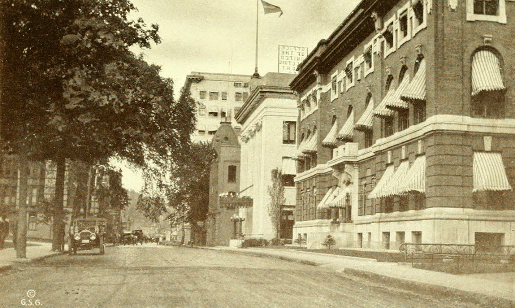
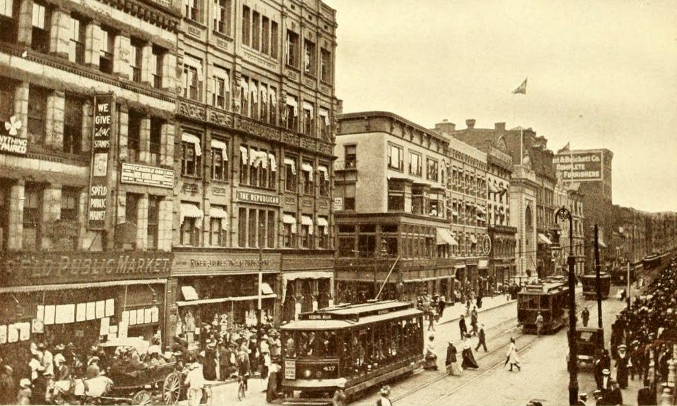
Main Street in Springfield, looking south from near Harrison Ave., around 1910-1913. Photo from Progressive Springfield, Massachusetts (1913).

401_1910-1913c-2Bprogressivespfld

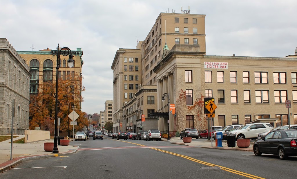
The same scene in 2017:


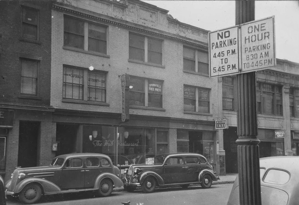
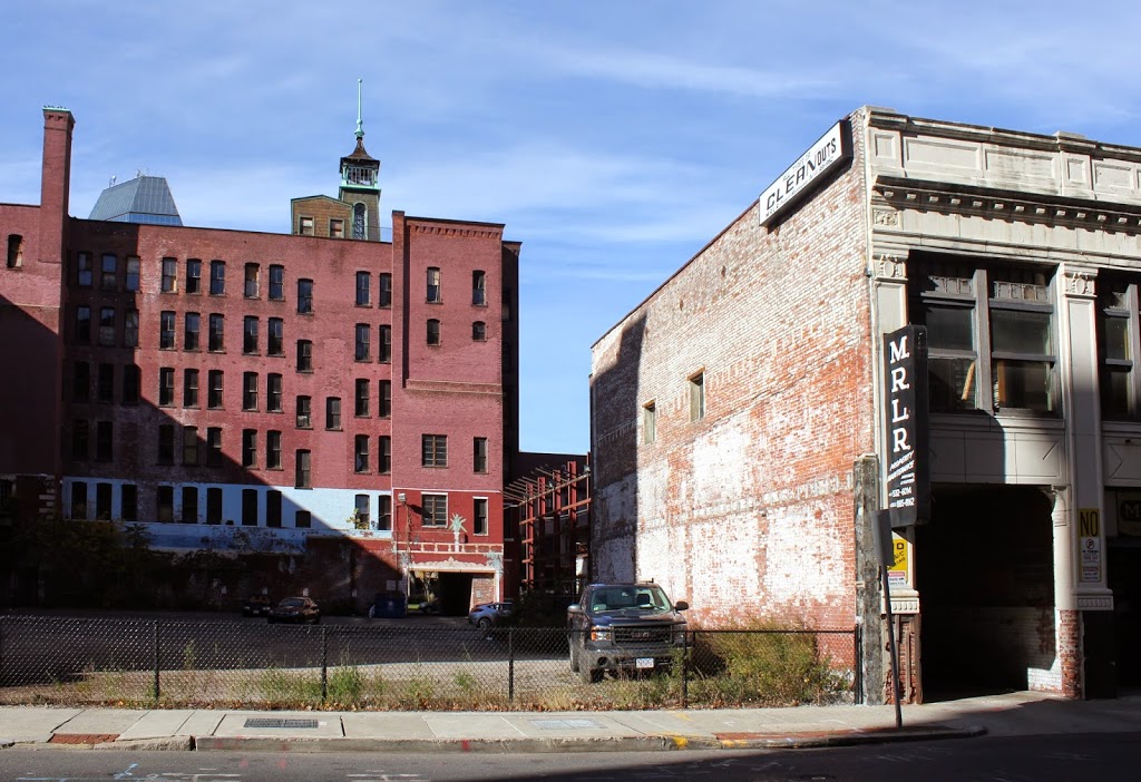
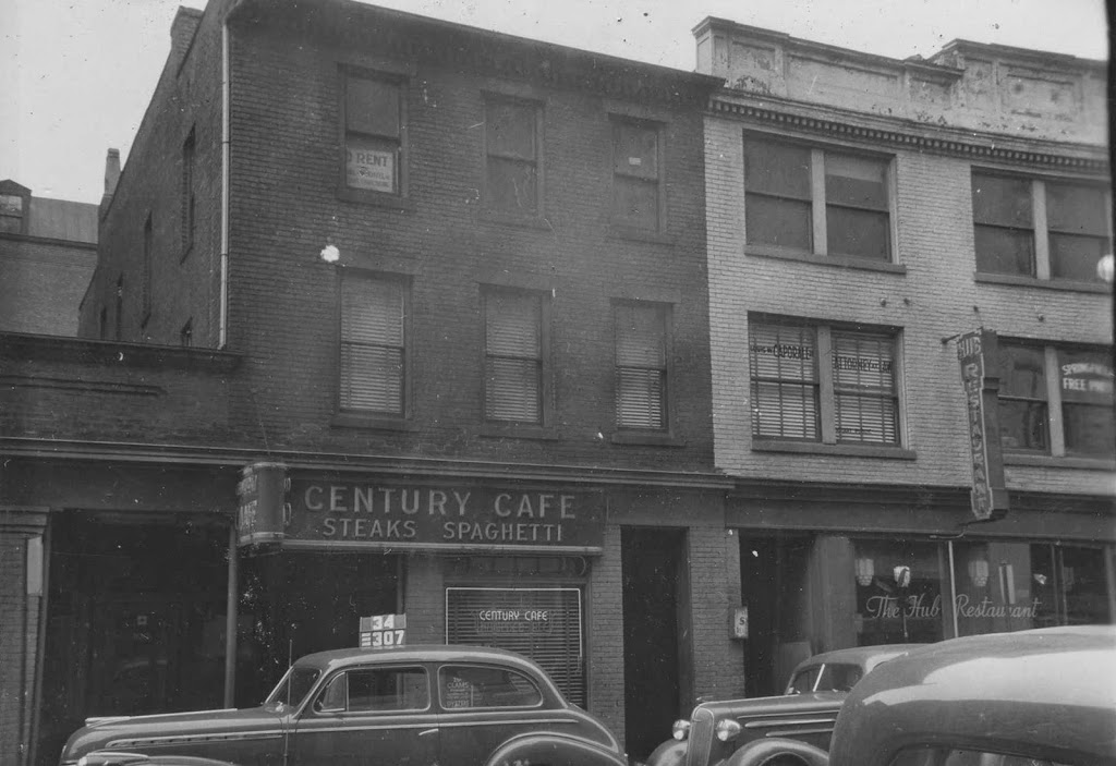
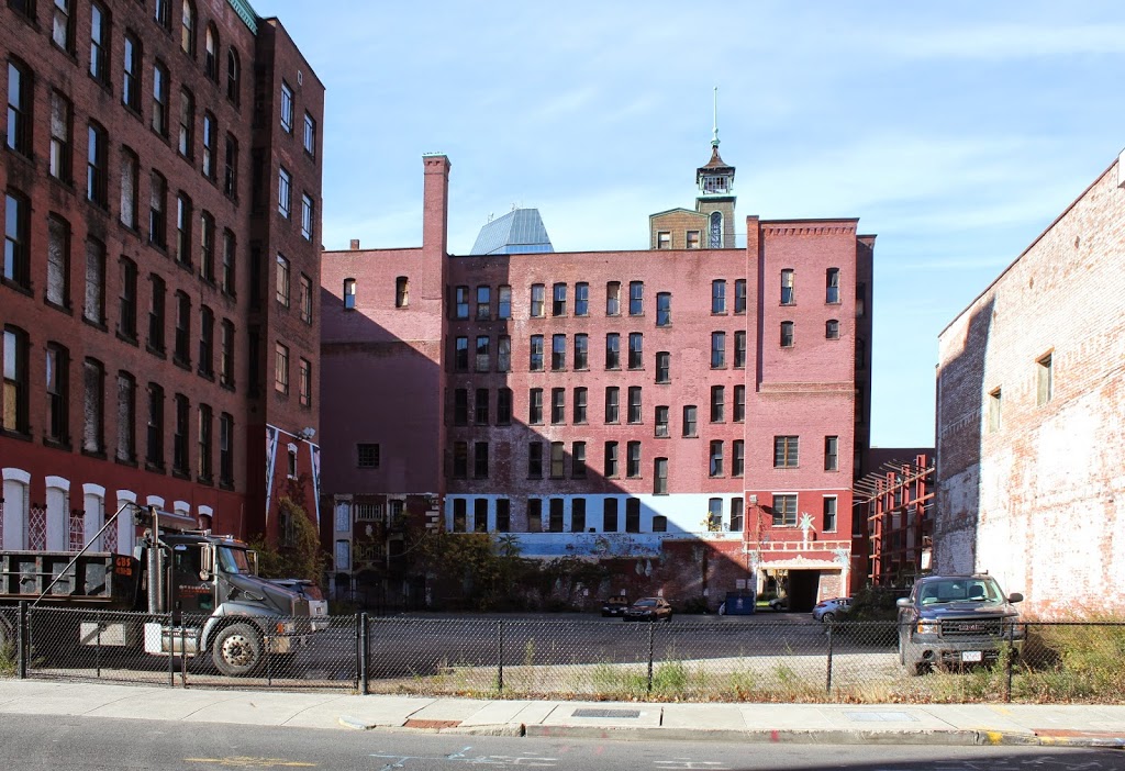
These views show some of the changes that have occurred on the east side of Main Street, south of Harrison Avenue.  The buildings in the foreground of the first photo are long gone; Today, Harrison Ave passes diagonally through those lots to cross Main Street where Boland Way (formerly Vernon Street) intersects.  The building just to the right of Harrison Ave in the first photo is also gone, replaced by the 10 story building in the 2014 photo.

However, most of the other buildings in the first photo are still there, including the former Johnson’s Bookstore building, which was built in 1861, around the same time as the two buildings on either side of it.  The facade was remodeled in 1908, but it once matched the buildings on either side of it.  To the right of the bookstore building is the oldest in the scene, the 1858 Republican Block.  This was the home of the Springfield Republican newspaper from 1858 to 1867, during the era when the paper was endorsing Abraham Lincoln for president and reporting news on the Civil War and Lincoln’s assassination.  Beyond the Republican Block is the Union Trust Building, with its distinctive arch over the main entrance.  It was built in 1907, and both it and the Republican Block are on the National Register of Historic Places.

State Street, Springfield, Mass

State Street in Springfield, around 1910-1913. Photo from Progressive Springfield, Massachusetts (1913).

397_1910-1913c-2Bprogressivespfld

State Street in 2014:

397_2014

The scene in 2023:

It will be interesting to do another “now” photo in a couple years, because this scene will be changing soon. Taken looking east on State Street from in front of the Hampden County Hall of Justice, this scene shows several buildings that will be demolished or substantially altered when the casino is built. The building on the right-hand side of the 2014 photo is the United Electric Company building, which had just been built shortly before the first photo was taken, and will be (mostly) demolished in the near future, with the casino retaining only the façade. A few other buildings along State Street will also either be demolished or have just he façade saved.

Other buildings in the photos include the Court Square Hotel, which extends across the block from Elm Street to State Street, and the Nayasset Club building, on the far right of the first photo.  The Nayasset Club was a social organization that at the time included many of Springfield’s prominent citizens.  The building is now gone, and in its place is a parking lot across from the old Hampden County Courthouse, which is barely visible on the left-hand side of the 2014 photo.

2023 update: As promised when I wrote the post back in 2015, I have updated the post to include a third photo, which shows the same scene following the completion of the MGM casino on the right side of the street.

Parsons Tavern, Springfield, Mass

Parsons Tavern on Court Street in Springfield, sometime in the late 1800s. Photo from Our County and Its People: A History of Hampden County, Massachusetts (1902).

Taverns

The scene in 2023:

When Springfield was settled by European colonists in 1636, it was at a strategic location along several different transportation routes.  As the years went by, the modes of transportation changed, but Springfield remained an important crossroads.  By the late 1700s, there were three major routes from New York to Boston, the northernmost of which went through Boston.  Although a less direct route than the other two, the Springfield route reportedly offered the best taverns, and in Springfield the best was Parsons Tavern.

The tavern was originally built on what is today the southeastern corner of Court Square, and was operated by Zenas Parsons.  During its time in operation, it hosted at least two presidents, the first of whom was George Washington in October, 1789.  Washington was on his way to Boston, and made a stop in Springfield to inspect the Armory.  He stayed overnight at Parsons Tavern, and wrote in his diary that “A Colo. Worthington, Colo. Williams (Adjutant General of the State of Massachusetts), Genl. Shepherd, Mr. Lyman and many other Gentleman sat an hour or two with me in the evening at Parson’s Tavern where I lodged and which is a good House.”  Years later, in 1817, President James Monroe also visited the tavern, not long before it was moved in order to make way for Court Square.

The tavern was relocated to Court Street around 1820, and it was eventually divided into a four-family apartment building. The top photo shows it in that location, probably sometime in the late 19th century. It stood here until 1897, when it was demolished. Today, the site of the building is a parking lot adjacent to the G.A.R. Hall, across East Columbus Avenue from Symphony Hall.

104-108 State Street, Springfield, Mass

The buildings at 104-108 State Street in Springfield, around 1938-1939. Photo courtesy of the Springfield Preservation Trust.

388_1938-1939-2Bspt

The scene in 2014:

388_2014

These photos were taken facing just to the right of the ones in this post, and the 1930s photo shows the building once occupied by The Hub Restaurant.  As mentioned in the other post, this building was probably taken down around the same time as the Court Square Theater to make room for the present-day parking lot, although the building to the right of it still survives; this is the Shean Block, which was built in 1927 at the corner of Main and State Streets.

Notice the “No Parking” sign in the foreground – I’m not quite sure why parking was restricted from 4:45 to 5:45; perhaps this was to accommodate rush hour traffic?  At the time, State Street was part of Route 20, so this section of road was probably pretty busy in the pre-interstate days.  There is also a clue as to the date of this photo – a sign in the second floor window reads “Springfield Free Press,” which was published starting in September 1939.  If the estimated date range of 1938-1939 is accurate, then the photo was most likely taken in the fall of 1939.

102 State Street, Springfield, Mass

The building at 102 State Street in Springfield, around 1938-1939. Photo courtesy of the Springfield Preservation Trust.

387_1938-1939-2Bspt

The scene in 2014:

387_2014

Both the Century Cafe and The Hub Restaurant are long gone, as are the buildings that they once occupied.  In the 1930s photo, these buildings fronted State Street, and behind them was the Court Square Theater, which was part of the Court Square Hotel.  The hotel part of the building is still there, to the left and in the background of the 2014 photo, but the theater itself was demolished in 1956 to make room for the parking lot.  It was probably around this time that the buildings on State Street were demolished.

Springfield Institution for Savings, Springfield, Mass

The Springfield Institution for Savings building on Elm Street in Springfield, around 1910. Image courtesy of the Library of Congress, Detroit Publishing Company Collection.

Banks

The site in 2014:

370_2014

The first photo shows the former home of the Springfield Institution for Savings, one of Springfield’s first banks.  Today, the building no longer exists, and neither does the company.  SIS is now part of TD Bank, and the site of the building is now part of the Hampden County Courthouse.  Even the street that the bank was once on, Elm Street, no longer really exists.  It used to extend from Main Street to present-day East Columbus Avenue, but the construction of the new courthouse in the 1970s caused the street to be truncated, and today it is a street in name only, as the section along Court Square is gated off, and the section next to Old First Church is essentially a parking lot for courthouse employees.

What really interested me in this picture, though, is the car parked outside.  Here is a close-up of it:

4a23747a.tif

Along with giving us a clue as to the date (the license plate appears to read “1910”), it also shows an intriguing and long-forgotten part of Springfield history.  The car was made by Springfield-based Knox Automobile Company, who made cars in the city from 1900 until 1914, and trucks until 1924.  Their factory was on Wilbraham Road in the Mason Square neighborhood, right across the street from the Indian Motorcycle factory.  The Knox building is still there, although it is in pretty rough shape and was included in the 2014 list of Springfield’s most endangered buildings.

I am fairly certain that the car in the photo is a 1909 Model “O,” although I am no expert on early 20th century automobiles, so if someone more knowledgeable than me knows otherwise, let me know. Assuming it was a Model “O,” though, it would’ve been $3,000 car 1909.  Adjusted for inflation, that would be over $75,000 in 2014 dollars, so the owner would’ve been a fairly wealthy person.  Today, though, cars don’t look like that, as the pickup truck and station wagon bear witness to in the 2014 photo.  However, at least one 1909 Knox Model “O” still exists today; this article explains the process of restoring the car and includes plenty of post-restoration photos.