Customshouse, Providence, RI

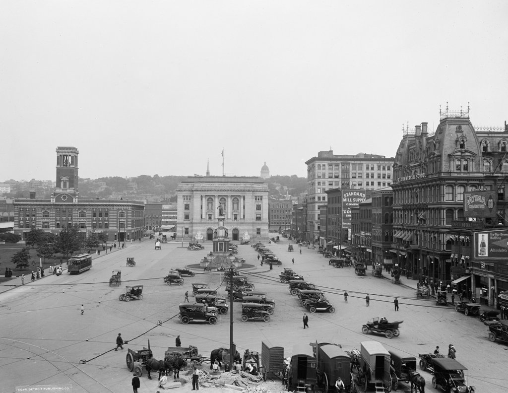
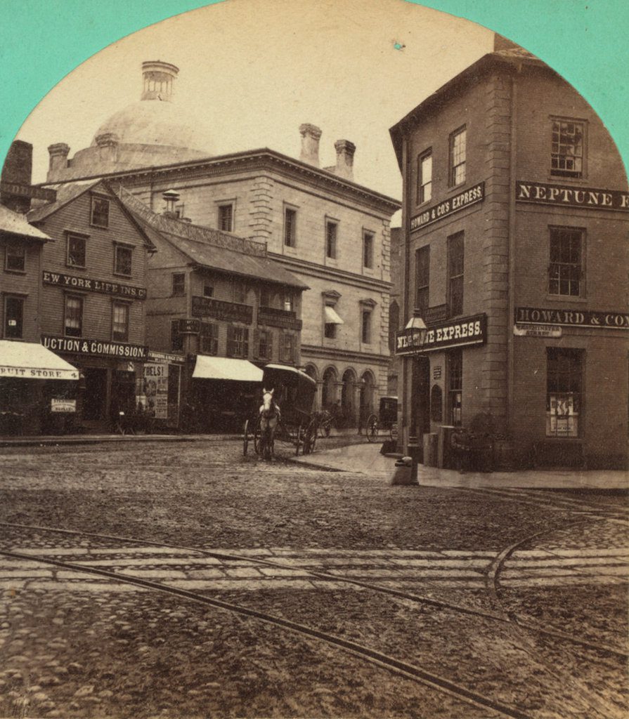
Looking down Weybosset Street from Westminster Street in Providence in 1868, with the U.S. Customshouse in the background. Image courtesy of the New York Public Library.
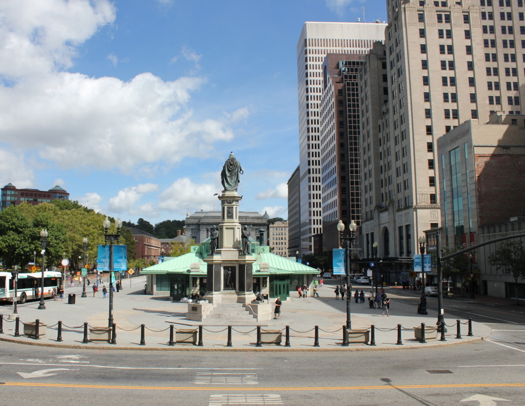
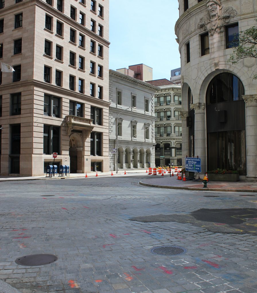
1085_1868-nypl

The scene in 2016:

1085_2016
In the first photo, this scene is dominated by the U.S. Customshouse, a domed, three-story granite building that had been completed just 11 years earlier, in 1857. It was designed by Ammi B. Young, during his time as Supervising Architect of the Treasury. His works included many prominent buildings, such as the old Vermont State House, part of the Treasury Building in Washington, DC, and the Custom House in Boston.

Young designed the custom houses in Boston and Providence about 20 years apart, and the two buildings reflect a shift in architectural tastes during the time. Although both were constructed of granite, Boston’s earlier building was Greek Revival, but by the time Providence’s Customshouse was built, Italianate architecture was far more common. Gone were the massive columns and triangular pediments, replaced instead with design elements such as arches, window cornices, and quoins on the corners.

When the first photo was taken, the Customshouse was surrounded by an assortment of low-rise commercial buildings, many of which were wood and probably dated back to the early 19th century. However, over time these buildings disappeared, and were replaced by much taller skyscrapers, dwarfing the old Customshouse. The first of these skyscrapers was the Banigan Building, built in 1896 on the left side of the present-day scene. It was followed in 1913 by the even taller Turk’s Head Building on the right side of the photo, which was constructed on a triangular lot and bears some resemblance to New York’s Flatiron Building.

Because Providence was a major port in New England, the Customshouse served an important function housing the offices of the city’s Collector of Customs. However, despite its name, the building also included the city’s main post office, a federal courtroom, and the offices of the federal District Attorney. Consequently, while Providence’s skyline was growing, so was the need for space in the old building.

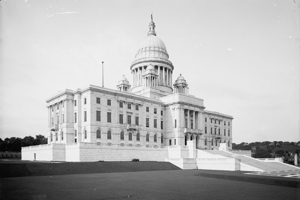
The problem was solved in 1908, with the completion of a new Federal Building at Exchange Plaza. Even this new building was not enough, though. After sitting vacant for more than a decade, the old Customshouse was reopened in 1921 to provide additional space for federal offices. It remained in use until 1989, and was later sold to the State of Rhode Island. Today, it is used as offices for the State Courts System. Along with the turn-of-the-century skyscrapers around it, the 160 year old building is now part of the Customshouse Historic District on the National Register of Historic Places.

Exchange Plaza, Providence, RI

Looking east toward Exchange Plaza from City Hall in Providence, around 1913-1920. Image courtesy of the Library of Congress, Detroit Publishing Company Collection.

1084_1900-1920-loc

The scene in 2016:

1084_2016
Exchange Plaza has been at the center of downtown Providence since the 19th century, although both it and its surroundings have undergone many changes during this time. In 1847, the city’s first railroad station was built here on the north side of the plaza. A new station was built a little further to the north in 1898, and City Hall Park opened on the site of the old station, on the left side of both photos. City Hall, where these photos were taken, was built on the west side of the plaza in 1878, across from the Soldiers’ and Sailors’ Monument. This statue was dedicated in 1871 and moved to the center of the plaza shortly before the first photo was taken, but was moved back to its original location in 1997.

The first photo shows a variety of transportation methods, including cars, trolleys, and horse-drawn carts. However, at this point cars had begun to dominate the city streets already, and Exchange Plaza had become a parking lot. On the opposite side of the plaza in both photos is the Federal Building, which was built in 1908 as a post office, courthouse, and custom house. It is still in use today, and is one of only a few buildings still standing here from the first photo.

The right side of the plaza, which was renamed Kennedy Plaza in 1964, is now dominated by skyscrapers. In the first photo, the most prominent building here was the Butler Exchange, a six-story commercial block on the far right. It stood here from 1873 to 1925, and after its demolition it was replaced by the present-day 111 Westminster Street building. Completed in 1928, this 26-story skyscraper remains the tallest building in Rhode Island nearly 90 years later.

Today, the only building still standing from the right side of the first photo is the Exchange Bank Building, barely visible in the distance at the corner of Exchange Street, diagonally across from the Federal Building. Completed in 1845, it predates even the original railroad station that stood opposite the plaza. However, it is not the oldest building in the scene. That distinction likely goes to the First Baptist Church in America, which was built in 1775 on the other side of the Providence River. The top of its spire is visible in both photos, behind the Federal Building.

Market Square, Providence, RI

Market Square, as seen from across the Providence River in 1865. Image courtesy of the New York Public Library.

1074_1865-nypl

Market Square in 2016:

1074_2016
Located at the foot of College Hill on the east side of the Providence River, Market Square was for many years an important commercial and political center of the city. The oldest building in the first photo is Market House on the right side. Like other colonial buildings such as Boston’s Faneuil Hall, the Market House functioned as a market on the first floor, but had upper floors that were used for public meetings. It opened in 1775, just in time to witness the start of the American Revolution, which included an anti-British protest where colonists burned tea outside the building. Later in the war, French soldiers were housed in the building in 1781, prior to their participation in the decisive Battle of Yorktown later in the year.

Providence was incorporated as a city in 1832, and that same year the newly-formed city government moved into the Market House. The building soon became too small for the needs of the growing city, but it took years before a suitable site for a new City Hall was finally chosen. In 1878, the present City Hall opened on the other side of the river at Exchange Place, and the Market House was put to new use as an office building.

Today, the Market House is the only building left from the first photo. The 19th century commercial blocks on the left were demolished by the first half of the 20th century to build the Rhode Island School of Design Auditorium, and the buildings in the center were also subsequently demolished. The entire scene around Market Square is now part of the Rhode Island School of Design, including the Market House itself. The historic building was transferred to the school in 1948, and is now in use for classroom space, although very little has changed in its exterior appearance over the past 150 years.

City Hall, Providence, RI

Providence City Hall as seen from Fulton Street, around 1906. Image courtesy of the Library of Congress, Detroit Publishing Company Collection.

1070_1906c-loc

City Hall in 2016:

1070_2016
Providence’s City Hall, located at the western end of Exchange Place, was the city’s first permanent municipal building. For many years, the city government had used the colonial-era Market House on the opposite side of the Providence River, but after decades of disputes over the location of a new building, this site was finally chosen in the 1870s. It was completed in 1878, and was designed in the Second Empire style by Samuel J.F. Thayer, a Boston architect who probably took some inspiration from Boston’s own City Hall.

Many years later, the building remains in use as City Hall, and has seen some notable visitors in the process. In 1902, several years before the first photo was taken, President Theodore Roosevelt gave a speech from the steps of the building. More than a half century later, in 1960, John F. Kennedy also gave a speech here, the day before he was elected president. Today, the building is on the National Register of Historic Places, and it is the only feature in the first photo that has not changed. Even the statue on the right side has undergone changes. It was dedicated in 1871 as the Soldiers’ and Sailors’ Monument, but was moved in 1913, and did not return to its original location until 1997.

Rhode Island State House, Providence, RI

The south side of the Rhode Island State House in Providence, around 1906. Image courtesy of the Library of Congress, Detroit Publishing Company Collection.

1058_1906c-loc

The scene in 2016:

1058_2016
Rhode Island is known for having the smallest land area of any US state, but despite its diminutive size, it had an unusual state capital arrangement for many years, with the legislature alternating sessions between the five county courthouses, effectively giving the state five capital cities. While much larger states managed to make do with just one capital city, this practice continued until 1854, when the rotation was reduced to just two, Providence and Newport. Having joint capitals was not unique to Rhode Island – neighboring Connecticut did the same for many years – but Rhode Island continued the practice until 1900.

At this point, when the legislature was in Providence, they were still meeting in the small colonial-era courthouse on Benefit Street. It hardly compared to the far grander capitol buildings other New England states such as Connecticut and Massachusetts, so in 1895 construction began on the present-day Rhode Island State House. It was built on Smith Hill, a hill that overlooks downtown Providence on the other side of the Woonasquatucket River. Its architecture resembles the US Capitol Building, with wings on either side for the two legislative houses and a large rotunda in the center, and it was designed by the prominent firm of McKim, Mead and White in their distinctive Classical Revival style.

The Rhode Island legislature began meeting in the new building in 1901, although it was not completed until 1904, after nearly a decade of construction. Today, the area around the State House has seen some dramatic changes. Interstate 95 now passes just west of here, and just to the east is the Northeast Corridor, the busiest passenger rail line in the country. To the southwest is Providence Place, a large shopping mall with adjacent parking garages. However, here on the State House grounds, very little has changed. The grounds retain a park-like atmosphere, and the historic building itself is still the seat of Rhode Island’s state government.

City Hall, Halifax, Nova Scotia

Halifax City Hall, seen from the Grand Parade around 1899. Image from Souvenir, One Hundred and Fiftieth Anniversary, City of Halifax (1899).

1057_1899c-souvenir150halifax

The building in 2016:

1057_2016
As mentioned in the previous post, Halifax is the largest city in Canada’s Maritime provinces, and has had close ties to New England over the years. The heart of downtown Halifax has long centered around the Grand Parade here, a city square located between Barrington and Argyle Streets. On the south side of the square is St. Paul’s Church, the oldest building in the city, and on the north side is City Hall, seen here. It was completed in 1890, with an architectural design that is based on the Second Empire style, which had been particularly popular a couple of decades earlier.

The building sustained some damage in the 1917 Halifax Explosion, but unlike the northern part of the city, the downtown area was largely spared serious damage. Today, the building remains essentially the same as it did in the 1890s view, and is listed as a National Historic Site of Canada. Its jurisdiction has significantly expanded over the years, though, In 1996, all of the existing cities and towns in Halifax County were consolidated into the Halifax Regional Municipality. This essentially extended the Halifax city limits to include over 2,100 square miles of land, more than double the land area of Rhode Island, but the old City Hall remains in use as the seat of the municipal government, over 125 years after its completion.