Alexander Hamilton Statue, Boston

The statue of Alexander Hamilton, located on the Commonwealth Avenue Mall between Arlington and Berkeley Streets, around 1865-1885. Image courtesy of the Boston Public Library.

The statue in 2021:

These two photos show the statue of Alexander Hamilton on the Commonwealth Avenue Mall in Boston. It was the work of artist William Rimmer, and it was commissioned by Thomas Lee, who presented it to the city of Boston as a gift. The statue stands nine feet, four inches tall, and it was carved out of Concord granite. It stands on a base of blue Quincy granite, which also includes a granite plaque featuring profiles of George Washington, Alexander Hamilton, and John Jay.

The statue was unveiled here on August 24, 1865. The public reception was somewhat mixed, with some criticizing the use of granite rather than more conventional materials such as bronze, while others criticized the design itself. Contemporary sculptor Truman Howe Bartlett called it “the indifferent work of a genius, not the consistent labor of talent,” and art critic George B. Woods observed that Hamilton seemed to be “swathed like an infant or a mummy.” Nonetheless, other such as the statue’s benefactor, Thomas Lee, appreciated the design, and the harsh criticism of the statue seemed to soften over time.

Today, the statue still stands here more than 150 years after it was installed. Its surroundings have also seen few changes over the years, and most of the houses from the first photo are still standing today, although they are largely hidden by the trees. Overall, the Back Bay remains a well-preserved example of late 19th century residential architecture, and the tree-lined Commonwealth Avenue Mall is a major centerpiece of the neighborhood.

Soldiers and Sailors Monument, Boston

The Soldiers and Sailors Monument on Boston Common, around 1890-1901. Image courtesy of the Library of Congress, Detroit Publishing Company Collection.

The monument in 2021:

This monument stands on Boston Common, and it was dedicated in 1877 in honor of the soldiers and sailors from Boston who fought for the Union during the Civil War. Nearly every town or city in New England has some kind of Civil War monument for its residents, but this one in Boston is particularly grand. It rises 126 feet in height, and it features five bronze statues, four bronze bas relief plaques, and a variety of other carvings and sculptures. It was the work of prominent Boston sculptor Martin Milmore, whose other noteworthy Civil War monuments include the Sphinx in Mount Auburn Cemetery.

The design of the monument was based on ancient Roman victory columns. On the lower part of the column are carvings of four allegorical figures, representing north, south, east, and west, and symbolizing the reunification of the country. On the top of the column is a larger-than-life bronze statue representing America, with the flag in her left hand and a sheathed sword and laurel wreath on her right hand, symbolizing peace and victory.

Near the base of the monument are four bronze statues, each nine feet in height. Two are male figures and two are female, and they represent the Army, the Navy, Peace, and History. From the angle of these two photos, the two statues in the foreground are Peace on the left and Navy on the right. The statue of a soldier, representing Army, is barely visible on the left side, and the History statue is hidden from view in this scene. In between the statues are four bronze bas reliefs, each depicting a scene related to the war. One shows soldiers departing for the war, another shows them returning, and the other two commemorate the Navy and the Sanitary Commission.

The statue was dedicated on September 17, 1877, on the fifteenth anniversary of the Battle of Antietam. It was a major event, drawing Civil War veterans from across the state, along with many prominent dignitaries, including Generals George B. McClellan and Joseph Hooker. The day’s festivities began with a long procession to the Common, where the Colt’s Armory Band opened the ceremony with a hymn. The sculptor, Martin Milmore, then delivered brief remarks and presented the monument to the city. He was followed by Alderman Francis Thompson and Mayor Frederick Prince, who each gave an address. Next was the keynote speech, delivered by General Charles Devens, a Massachusetts native and Civil War general who was, by this point, serving in the Cabinet as the US Attorney General.

The first photo was taken several decades after the monument was installed here, at a time when many of the city’s Civil War veterans were still alive. Today, more than a century later, the city has undergone significant transformations, but this scene has remained essentially unchanged. The monument looks as good now as it did in the first photo, largely because of a major restoration that was completed in 2014. This project included cleaning and repointing the granite, along with removing, cleaning, repairing, and reinstalling the four pedestal statues.

Judges Cave, New Haven, Connecticut

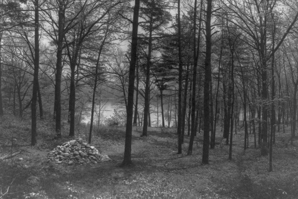
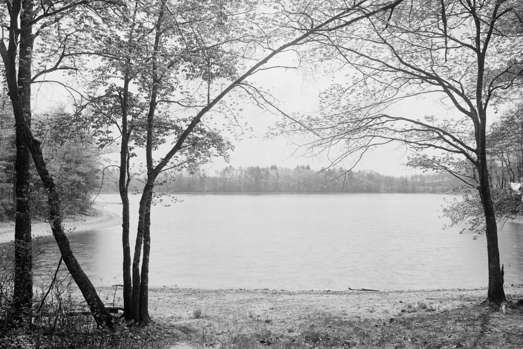
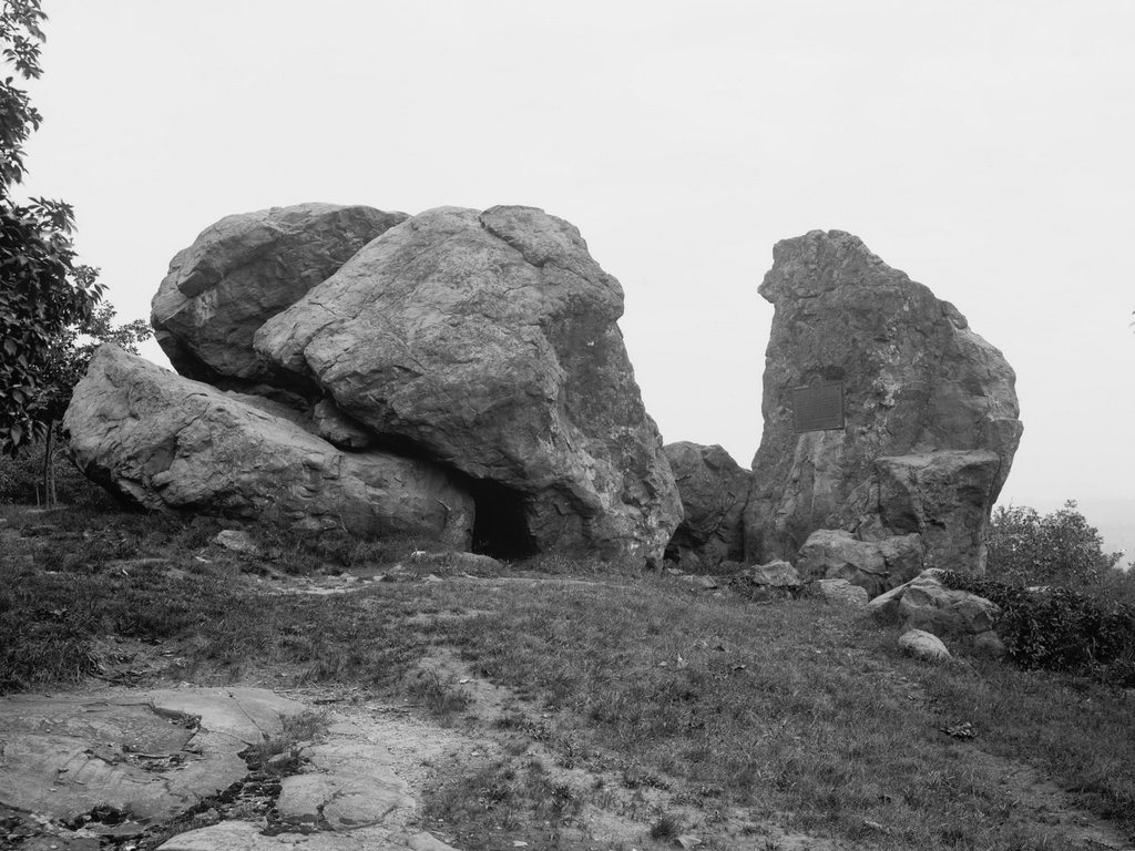
The Judges Cave on West Rock in New Haven, around 1901. Image courtesy of the Library of Congress, Detroit Publishing Company Collection.
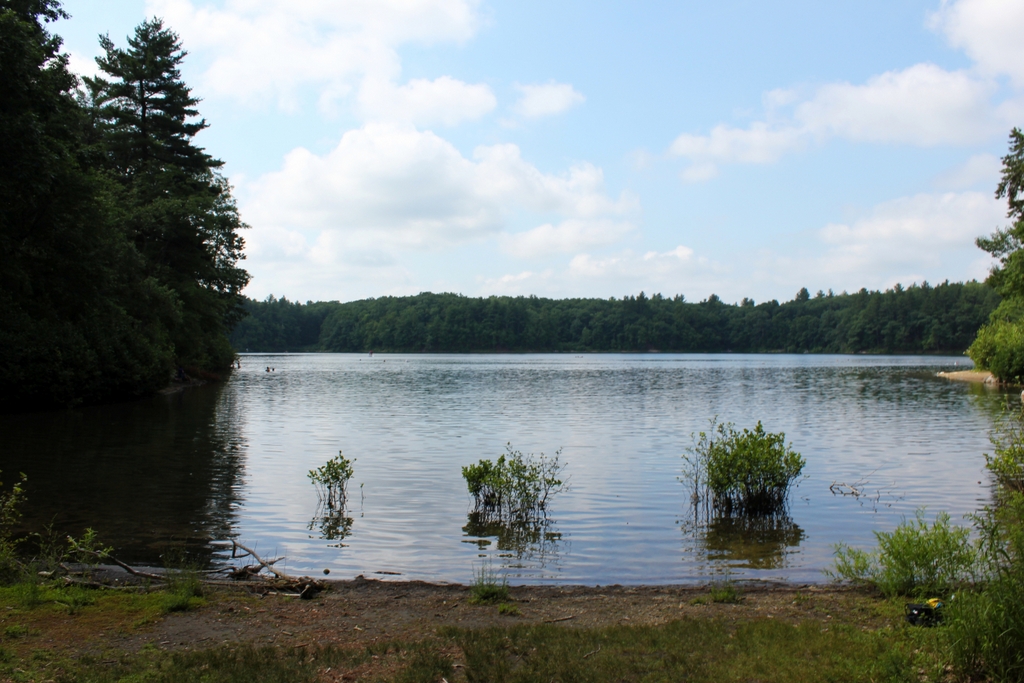
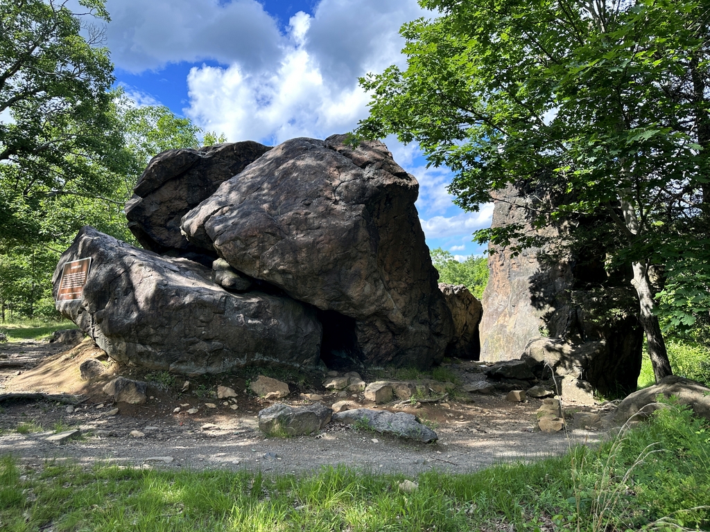
The scene in 2019:

The immediate origins of the American Revolution can be traced back to the 1760s, when colonists began protesting taxes that were being levied on the colonies in the aftermath of the French and Indian War. However, this was hardly the first time that the colonies had defied the British crown. A century earlier, following the English Civil War and the eventual restoration of the monarchy, the colony of New Haven protected several regicides who had signed the death warrant of Charles I in 1649. This ultimately helped lead to the downfall of the colony and its merger with Connecticut in 1664, but none of the regicides were ever captured, and the incident has lived on in New England lore.

John Dixwell, William Goffe, and Edward Whalley were three military officers who had fought on the side of Parliament during the English Civil War in the 1640s. Following the defeat of the Royalists, King Charles I was captured put on trial for treason, and was found guilty of being a “tyrant, traitor, murderer and public enemy.” These three men were among the 59 commissioners who signed his death warrant, and he was subsequently beheaded on January 30, 1649.

This led to a decade-long interregnum, during which time Puritan leader Oliver Cromwell took on the title of Lord Protector of the Commonwealth of England. However, this government collapsed soon after Cromwell’s death in 1558, and in 1660 Charles II, the son of Charles I, returned from exile became king. That same year, Parliament passed the Indemnity and Oblivion Act, which pardoned most of the people who took part in the war but specifically excluded the 59 regicides and other high-ranking leaders who were connected to the trial and execution of Charles I. Over the next few years, royal officials tracked down many of these people, who were then imprisoned or executed. Even those who were already dead could not escape punishment; the bodies of Cromwell and several other dead regicides were exhumed from their graves, publicly executed, and then beheaded.

In the meantime, Dixwell, Goffe, and Whalley fled to the New World, to seek shelter among the Puritans. The exact date and location of Dixwell’s arrival is unknown, but he was presumed dead by the British and was not actively pursued by royal authorities. As for Goffe and Whalley, they arrived in Boston in July 1660, and they lived openly in Cambridge, before news of the Indemnity and Oblivion Act reached the colony in the fall. Over the next few months, the colonial leaders debated what to do about the two men. Although many were sympathetic to them and their cause, they feared the consequences to the colony if they continued to shelter them. So, on February 26, 1661 Goffe and Whalley left Cambridge for New Haven, where they arrived on March 7.

Here in New Haven, the men initially lived with the Reverend John Davenport. However, within a few months they were again in danger. News of their formal arrest warrant, dated March 5, reached New Haven around the end of April. This was soon followed by the arrival of royal officials in nearby Guilford, where they met with Governor William Leete. He managed to delay them in Guilford for several days, allowing Goffe and Whalley to quite literally take to the hills in order to escape arrest.

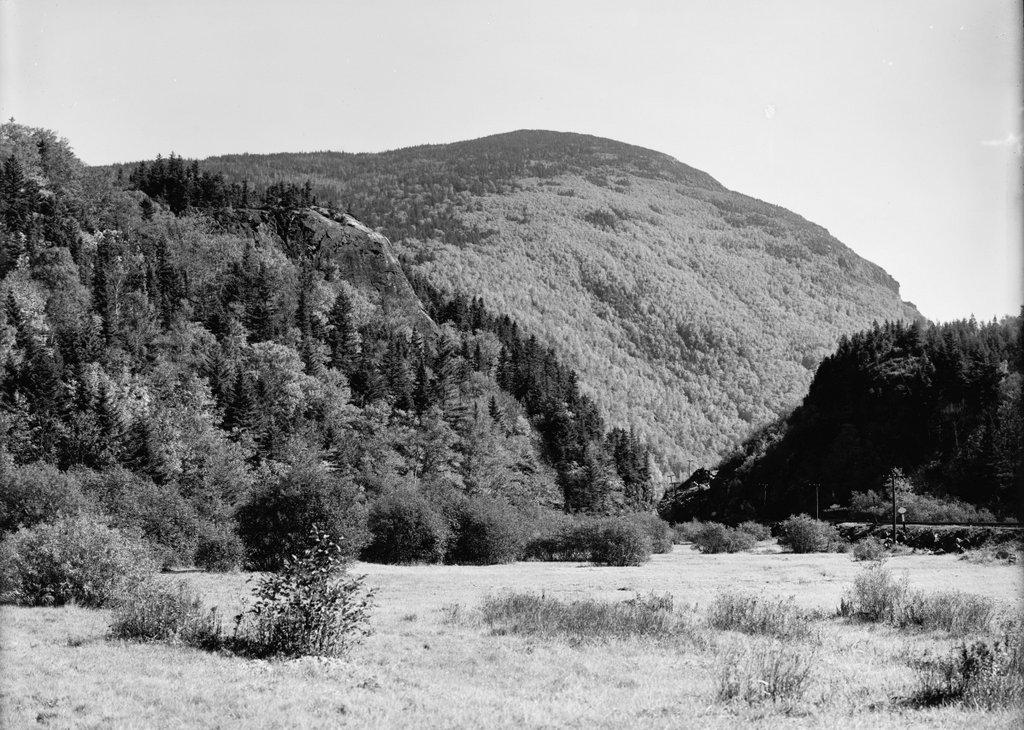
Goffe and Whalley spent several nights in temporary lodgings, aided by local farmers, before they were brought here to this rock formation on May 15. Although commonly referred to as Judges Cave, it is a cave in only the most generous sense of the word. In reality, it is a pile of boulders that, in a few areas, overhang enough to provide minimal shelter from the elements.  It is located high atop West Rock, a traprock ridge located about three miles northwest of the center of New Haven. At the time, this was a remote, sparsely-settled area, and they were able to live here for nearly a month without being detected.

Throughout this month, Goffe and Whalley received food every day from Richard Sperry, a local farmer who lived about a mile from here. They spent several nights at a nearby house during periods of inclement weather, but otherwise they lived here on the hill, which they named Providence Hill. In the meantime, royal officials were diligently searching for them in New Haven, offering generous rewards for their capture while also threatening Reverend Davenport for having aided them. The two regicides considered turning themselves in, in order to spare the colony any further trouble, but Governor Leete convinced them to remain in hiding. Within a few years, though, New Haven’s aid to the regicides would be a contributing factor in the demise of the colony, which was absorbed by the neighboring Connecticut colony in 1664.

According to legend, it was ultimately not royal officials who drove Goffe and Whalley from this cave, but rather a mountain lion that made an appearance at the entrance to the cave and frightened the two men. They left here on June 11, and lived at two other locations in the vicinity of West Rock for the next few months before finding more permanent lodgings at a house in Milford. They remained at this house for the next two or three years, before eventually moving to Hadley, Massachusetts, where they spent the rest of their lives in safety.

Because of the obvious need for secrecy in the movements of the regicides, there are few contemporary sources to corroborate these events. Perhaps the only primary source document was a diary that Goffe kept from 1660 to 1667, which he wrote in an easily-decipherable shorthand. This diary is now lost to history, but in the mid-1700s it was owned by Thomas Hutchinson, the royal lieutenant governor and later governor of the Province of Massachusetts Bay.

Aside from his role in colonial government, Hutchinson was also a historian, and in 1764 he published The History of the Colony of Massachusetts Bay. This book included an account of the regicides, which was based largely on Goffe’s journal. However, as a loyalist in the years leading up to the American Revolution, Hutchinson took a dim view of the regicides, and this bias is evident in much of his narrative. For example, he emphasizes the role that colonial officials had in trying to apprehend them, in an effort to portray the majority of 17th century New Englanders as having been loyal to the crown

Regardless of the biases, and the fact that it was written a century after the events happened, Hutchinson’s book provides the earliest significant account of the regicides and their flight through New England. The section relevant to their time here at Judges Cave, which is part of a lengthy footnote, reads as follows:

About that time, news came to Boston that ten of the judges were executed, and the governor received a royal mandate, dated March 5, 1660, to cause Whaley and Goffe to be secured. This greatly alarmed the country, and there is no doubt that the court were now in earnest in their endeavours to apprehend them; and to avoid all suspicion, they gave commission and instruction to two young merchants from England, Thomas Kellond and Thomas Kirk, zealous royalists, to go through the colonies, as far as Manhados, in search of them. They had friends who informed them what was doing, and they removed from Mr. Davenport’s to the house of one Jones, where they lay hid until the 11th of May, and then removed to a mill, and from thence, on the 13th, into the woods, where they met Jones and two of his companions, Sperry and Burril, who first conducted them to a place called hatchet-harbor, where they lay two nights, until a cave or hole in the side of a hill was prepared to conceal them. This hill they called Providence hill; and there they continued, from the 15th of May to the 11th of June, sometimes in the cave, and, in very tempestuous weather, in a house near to it. During this time, the messengers went through New-Haven to the Dutch settlement, from whence they returned to Boston by water. They made diligent search, and had full proof that the regicides had been seen at Mr. Davenport’s, and offered great rewards to English and Indians who should give information that they might be taken, but, by the fidelity of these three friends, they remained undiscovered.

Goffe’s journal remained in Hutchinson’s possession until 1765, when his house was ransacked by a Patriot mob in protest of the Stamp Act. The journal was either lost or destroyed in the process, making Hutchinson’s book the only surviving description of its contents. However, at least one other prominent historian, future Yale president Ezra Stiles, had the opportunity to examine the journal before its disappearance. He saw it during a 1763 visit to Hutchinson’s house, and he subsequently wrote his own history of the regicides.

Unlike Hutchinson’s description of the regicides, which fills just seven pages in his massive multi-volume history of the colony, Ezra Stiles published an entire book about their exploits in 1794. Titled A History of Three of the Judges of King Charles I, the book is over 350 pages long, and it relies heavily on oral traditions that were passed down to the descendants of the men involved in helping the regicides. Like Hutchinson’s account, Stiles’s book also has a political slant, although in the opposite direction. Writing just a decade after the American Revolution, in the midst of republican, anti-monarchical sentiment, Stiles viewed the regicides in a positive light, and he even included a chapter in which he justified their actions.

Stiles’s seemingly uncritical use of oral tradition in his book would come under criticism from later scholars, including biographer Edmund S. Morgan. Writing in his 1962 book The Gentle Puritan: A Life of Ezra Stiles, 1727-1795, Morgan asserted that it “represents Stiles at his worst. It is a tedious hodgepodge of fact and fancy, compounded mainly out of dim recollections by old men and women of things their grandfathers had told them fifty years before.” One such recollection, which relates to the Judges Cave, came from an interview with Joseph Sperry, whose grandfather Richard Sperry had aided the regicides in 1661. Stiles provided the following account in his book, including a description of this cave:

In 1785 I visited aged Mr. Joseph Sperry, then living, aged 76, a grandson of the first Richard, a son of Daniel Sperry, who died in 1751, aged 86, from whom Joseph received the whole family tradition. Daniel was the sixth son of Richard, and built a house at the south end of Sperry’s farm, in which Joseph now lives, not a half a mile west from the Cave, which Joseph shewed me. There is a notch in the mountain against Joseph’s house, through which I ascended along a very steep acclivity up to the Cave. From the south end of the mountain for three or four miles northward, there is no possible ascent or descent on the west side, but at this notch, so steep is the precipice of the rock. I found the Cave to be formed, on a base of perhaps forty feet square, by an irregular clump or pile of rocks, or huge broad pillars of stone, fifteen and twenty feet high, standing erect and elevated above the surrounding superficies of the mountain, and enveloped with trees and forest. These rocks coalescing or contiguous at top, furnished hollows or vacuities below, big enough to contain bedding and two or three persons. The apertures being closed with boughs of trees or otherwise, there might be found a well covered and convenient lodgement.

After this description of the cave and its surroundings, he wrote of what he learned from Joseph Sperry:

Here, Mr. Sperry told me, was the first lodgment of the Judges, and it has ever since gone and been known by the name of the Judges’ Cave to this day. Goffe’s Journal says, they entered this Cave the 15th of May, and continued in it till the 11th of June following—Richard Sperry daily supplied them with victuals from his house, about a mile off; sometimes carrying it himself, at other times sending it by one of his boys, tied up in cloth, ordering him to lay it on a certain stump and leave it: and when the boy went for it at night he always found the basons emptied of the provisions, and brought them home. The boy wondered at it, and used to ask his father the design of it, and he saw no body. His father only told him there was some body at work in the woods that wanted it. The sons always remembered it, and often told it to persons now living, and to Mr. Joseph Sperry particularply [sic].

They continued here till 11th of June. Mr. Joseph Sperry told me that the incident which broke them up from this Cave was this, that this mountain being a haunt for wild animals, one night as the Judges lay in bed, a panther, or catamount, putting his head into the door or aperture of the Cave, blazed his eye-balls in such a hideous manner upon them, as greatly affrighted them. One of them was so terrified by this grim and ferocious monster, her eyes and her squawling, that he took to his heels, and fled down the mountain to the Sperry’s house for safety. They thereupon considered this situation too dangerous, and quitted it. All the Sperry families have this tradition.

Aside from the events here in New Haven, the subsequent lives of Goffe and Whalley in Hadley are shrouded in mystery and legend. They lived at the home of the Reverend John Russell, but it appears that most townspeople were unaware of their identities. At some point around 1664, they were reunited with John Dixwell, the third regicide who had fled to New England. He eventually moved to New Haven, where he lived under the name John Davids until his death in 1689. Because the authorities believed that he was dead, he was able to live in relative security, and does not appear to have required the use of this cave or any other improvised shelters.

In the meantime, Edward Whalley died in Hadley around 1675 of natural causes, but Goffe lived long enough to become the subject of perhaps the most memorable regicide legend. According to tradition, at some point in either 1675 or 1676 the town of Hadley was facing an attack by Native Americans during King Philip’s War. The townspeople started panicking, but then an elderly man, identified in the legend as William Goffe, emerged and began to take charge. Some 30 years after he fought the Cavaliers on the battlefields of the English Civil War, he rallied the people and led their defense, and succeeded in saving the town. Then, as suddenly as he had appeared, the “Angel of Hadley” was gone.

As is the case for nearly all of the regicide-related stories, the first published account of the Angel of Hadley did not appear for nearly a century, until Thomas Hutchinson included it in his book in 1764. He included it at the end of his lengthy footnote on the movements of the regicides, writing:

The town of Hadley was alarmed by the Indians in 1675, in the time of publick worship, and the people were in the utmost confusion. Suddenly, a grave elderly person appeared in the midst of them. In his mien and dress he differed from the rest of the people. He not only encouraged them to defend themselves; but put himself at their head, rallied, instructed and led them on to encounter the enemy, who by this means were repulsed. As suddenly, the deliverer of Hadley disappeared. The people were left in consternation, utterly unable to account for this strange phœnomenon. It is not probable, that they were ever able to explain it. If Goffe had been then discovered, it must have come to the knowledge of those persons, who declare by their letters that they never knew what became of him.

Writing in his book 30 years after Hutchinson, Stiles repeats essentially the same account of the incident, although his wording tends to be more explicitly favorable to Goffe. Rather than describing him as “a grave elderly person,” Stiles writes of “a man of a very venerable aspect.” He copies Hutchinson’s wording by saying “the inhabitants could not account for the phœnomenon,” but then added “but considering that person as an Angel sent of God upon that special occasion for their deliverance; and for some time after said and believed that they had been delivered and saved by an Angel.”

Stiles’s romanticized description helped to solidify the idea of the “Angel of Hadley,” and by the early 19th century the story had become a part of early American folklore. In his 1823 novel Peveril of the Peak, Scottish writer Sir Walter Scott alluded to the incident, and in 1829 James Fenimore Cooper included it in his novel The Wept of Wish-ton-Wish. Nathaniel Hawthorne, who was never one to pass up a good story about the Puritans, also took inspiration from it. As a young man, he visited Judges Cave here in New Haven, and one of his early short stories, “The Gray Champion,” was loosely based on the Angel of Hadley legend. In the story, the title character is a shadowy, mysterious figure who embodies the Puritan ancestors of New England. Instead of defending a town against Native Americans, Hawthorne’s hero challenges the authoritarian rule of Edmund Andros in the 1680s. The Gray Champion disappears once the threat to the colony is over, but over the years he continues to make appearances whenever American liberty is at stake, including nearly a century later on the battlefields at Lexington and Bunker Hill.

Although Hutchinson’s and Stiles’s accounts provided plenty of material for 19th century authors, many historians began calling into question the accuracy of these tales, especially the ones that were handed down to Stiles through multi-generational hearsay. Legends such as the Angel of Hadley might very well have some basis in reality, but at this point it is difficult to sort out fact from fiction, given the inherent secrecy involved in the regicides and their activities here in New England. As for the tradition that the regicides spent a month hiding here in this rock formation, it is impossible to state with certainty that this is true. However, this belief does not seem to have been seriously questioned, and it seems plausible that this was, in fact, their hiding place during the spring of 1661.

The first photo was taken around 1901, showing the south side of the rock formation. By this point, the surrounding land was owned by the city of New Haven as part of West Rock Park. In the early 1890s a road was opened up here to the Judges Cave, and then in 1896 a plaque was installed here on the rocks. This plaque, which is visible here on the right side of the scene, commemorates the role that this site played in sheltering the regicides, and it was presented to the city by the Society of Colonial Wars. The formal dedication occurred on October 14, 1896, and it was attended by dignitaries such as Mayor Frederick B. Farnsworth, state adjutant general Edward E. Bradley, future governor Simeon E. Baldwin, and writer Charles Dudley Warner. Along with providing a short description of the regicides, the plaque features the phrase “opposition to tyrants is obedience to God,” which had apparently been inscribed on the rocks here as early as 1803.

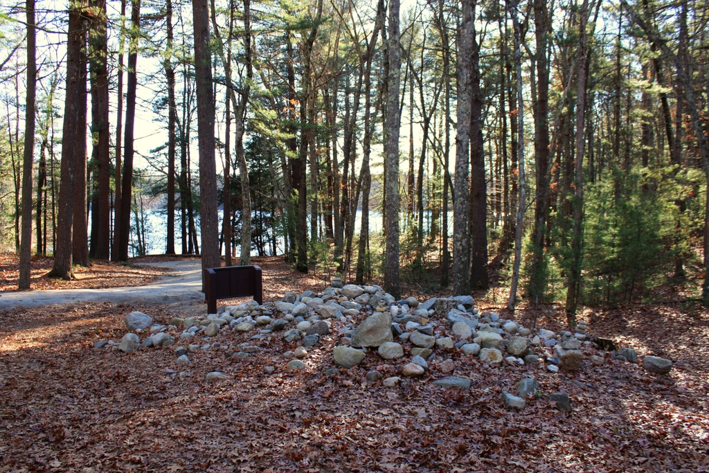
Today, more than a century after the first photo was taken, the Judges Cave still looks essentially the same. It is still preserved as parkland, although it was acquired by the state in 1975, and it is now named West Rock Ridge State Park. The Judges Cave remains an important landmark within the park, and the only real difference between these two photos is the loss of the plaque, which was evidently stolen at some point. Its replacement is a somewhat larger plaque on the left side, although it bears the same inscription as the original one. It includes the same closing line about how “opposition to tyrants is obedience to God,” reflecting the beliefs that had led two Puritans across the Atlantic Ocean and to this secluded cave on the fringes of European settlements in the New World.


Thoreau’s Cabin Site, Concord, Mass

The site of Henry David Thoreau’s cabin at Walden Pond in Concord, around 1908. Image courtesy of the Library of Congress, Detroit Publishing Company Collection.

The scene in 2021:

As explained in the previous post, Walden Pond was made famous by Transcendentalist writer Henry David Thoreau, who spent two years, two months, and two days living in a cabin here on the northern shore of the pond from 1845 to 1847. At the time, Concord was at the center of the Transcendentalist movement, and it was the home of several of its leaders, including Thoreau and his mentor, Ralph Waldo Emerson. They placed a strong emphasis on values such as being self-reliant, living a simple and nonmaterialistic life, and having an appreciation for the natural world. Because of this, Thoreau decided to embark on an experiment here at Walden Pond, in order to determine whether he could, as he put it, “front only the essential facts of life” by living in a small cabin with only the basic necessities of human life.

Thoreau wrote about his experience in his book Walden, published in 1854. In the first chapter, titled “Economy,” he described how he selected this site and began constructing the cabin in the spring of 1845, writing:

Near the end of March, 1845, I borrowed an axe and went down to the woods by Walden Pond, nearest to where I intended to build my house, and began to cut down some tall, arrowy white pines, still in their youth, for timber. . . . It was a pleasant hillside where I worked, covered with pine woods, through which I looked out on the pond, and a small open field in the woods where pines and hickories were springing up.

He steadily worked on the cabin throughout the spring, and it was finally ready to be occupied by early July. His first night here was on July 4, a coincidence that marked the start of his own personal independence:

When first I took up my abode in the woods, that is, began to spend my nights as well as days there, which, by accident, was on Independence Day, or the Fourth of July, 1845, my house was not finished for winter, but was merely a defence against the rain, without plastering or chimney, the walls being of rough, weather-stained boards, with wide chinks, which made it cool at night. The upright white hewn studs and freshly planed door and window casings gave it a clean and airy look, especially in the morning, when its timbers were saturated with dew, so that I fancied that by noon some sweet gum would exude from them. 

Thoreau ultimately completed the cabin by winter, including shingling the exterior and constructing a chimney and fireplace. The finished structure was, as he described it, “a tight shingled and plastered house, ten feet wide by fifteen long, and eight-feet posts, with a garret and a closet, a large window on each side, two trap doors, one door at the end, and a brick fireplace opposite.” In Walden, he itemized his construction costs, which added up to $28.12. The single largest expense was $8.03 for wood, much of which was recycled materials. In April he had purchased the shanty of James Collins, an Irish laborer who worked on the nearby Fitchburg Railroad, and he used this as a source of building materials.

The interior of the cabin was as spartan as its exterior, consisting of only minimal furnishings and personal possessions. Of these, he provided the following description:

My furniture, part of which I made myself, and the rest cost me nothing of which I have not rendered an account, consisted of a bed, a table, a desk, three chairs, a looking-glass three inches in diameter, a pair of tongs and andirons, a kettle, a skillet, and a frying-pan, a dipper, a wash-bowl, two knives and forks, three plates, one cup, one spoon, a jug for oil, a jug for molasses, and a japanned lamp.

Throughout the “Economy” chapter, Thoreau meticulously recorded his income and expenses, and concluded that, by simplifying his life, he was able to meet all of his expenses by working just six weeks out of the year. In contrast to his assertion earlier in the chapter that “[t]he mass of men lead lives of quiet desperation,” Thoreau argued based on his experiment here at Walden that:

In short, I am convinced, both by faith and experience, that to maintain one’s self on this earth is not a hardship but a pastime, if we will live simply and wisely; as the pursuits of the simpler nations are still the sports of the more artificial. It is not necessary that a man should earn his living by the sweat of his brow, unless he sweats easier than I do.

One popular misconception about Thoreau’s time here at Walden Pond is that he lived the life of a hermit in the wilderness. In reality, he was only a mile and a half from the center of Concord, and he often walked into town by way of the railroad, which ran just a quarter mile from here. As suggested by the presence of three chairs in the cabin, he also entertained guests here, although he found that the distance from town discouraged people from visiting for trivial reasons. In his book, he also wrote about interactions with other people who came to the pond for its natural resources, including fishermen and ice harvesters.

Thoreau moved out of the cabin on September 6, 1847, having decided that it was time to move on to the next stage in his life. It took another seven years before he completed his famous memoir about his stay here, and in the meantime his old cabin was put to a new use. Two years after Thoreau left, Ralph Waldo Emerson—who owned this land—sold the cabin to his gardener, who in turn sold it to two farmers. It was moved to a new location elsewhere in Concord, and it was used for grain storage for the next few decades, before ultimately being dismantled in 1868 and used for scrap. Thoreau did not live to see this, as he had died in 1862 at the age of 44, but he likely would have approved, considering he had built it from scrap lumber salvaged from an earlier structure.

In the meantime, the old site of Thoreau’s cabin began to attract attention as early as 1872, when Bronson Alcott—father of Louisa May Alcott—brought a visitor, Mrs. Mary Adams of Dubuque, Iowa, here to Walden Pond. At the time there was no marker here, so Mary suggested that a cairn might be an appropriate memorial. Writing in his journal, Alcott explained:

Mrs. Adams suggests that visitors to Walden shall bring a stone for Thoreau’s monument and begins the pile by laying stones on the site of his hermitage, which I point out to her. The tribute thus rendered to our friend may, as the years pass, become a pile to his memory. The rude stones were a monument more fitting than the costliest caring of the artist. Henry’s fame is sure to brighten with years, and this spot be visited by admiring readers of his works.

By the time the first photo was taken at the turn of the 20th century, the cairn had grown to a considerable size. The view faces essentially due south, with the pond visible beyond the trees in the distance. In the center of the photo is Thoreau’s Cove, the northernmost part of the pond, which comes within about 200 feet of the site of the cabin. The types of trees here are similar to what Thoreau would have seen, with a mix of pine and deciduous trees, but these actual trees were likely not old enough to have been here during Thoreau’s stay in the 1840s.

The cairn does not actually stand on the exact site of the cabin, although it is within a few yards. The actual location of the cabin was discovered in 1945 by archaeologist Roland W. Robbins, who uncovered the foundation of Thoreau’s chimney. These two photos were taken from right about the spot where the house stood, and it is now marked by an inscribed stone above the foundations of the chimney, along with nine cut stones that mark the dimensions of the cabin.

Today, aside from the stones marking the site of the cabin, the cairn is also still here. It is much larger than it was in the early 1900s, but it was briefly removed by state officials in 1975, before being returned here in 1978 after a public outcry over the loss of the “unsightly” memorial. Aside from the enlarged cairn, other changes since the first photo have included the path on the left, along with the sign next to the cairn, which features Thoreau’s famous quote about going into the woods because he “wished to live deliberately.” Overall, though, this scene still looks much the same as it did when the first photo was taken, and it is not all that different from what Thoreau would have seen from his front door some 175 years ago.

The pond and the surrounding land are now part of the Walden Pond State Reservation, which was established in 1922 after the Emerson family and several other landowners donated property around the pond to the state. Since then, the pond has continued to draw visitors for a variety of purposes, including swimming, fishing, walking the perimeter of the pond, or making a pilgrimage here to the site of Thoreau’s cabin. Although it is not located here at the original location, the park does feature a full-size replica of the cabin, which stands next to the parking lot a little less than a half mile from here, on the other side of Route 126. The following photos show the exterior and interior of the cabin, and were taken in 2021:

The exterior of the replica cabin, with the woodshed behind it


The interior of the replica cabin from the doorway

Thoreau’s Cove, Walden Pond, Concord, Mass

The view looking south from the northern shore of Walden Pond, around 1908. Image courtesy of the Library of Congress, Detroit Publishing Company Collection.

The scene in 2020:

Walden Pond is one of many glacially-formed kettle ponds scattered throughout the landscape of eastern Massachusetts. Despite its relatively small size, it is notable for being the deepest natural pond or lake in the state, with a maximum depth of 103 feet. However, it is best remembered for having been the subject of Henry David Thoreau’s 1854 book Walden. In this book, Thoreau describes the two years, two months, and two days that he spent living in a small cabin near the shore of the pond, from July 1845 to September 1847. His cabin was located about 200 feet behind where this photo was taken, just to the north of this cove, which is now known as Thoreau’s Cove.

Writing in Walden, Thoreau outlined his reasons for living here at Walden Pond, explaining how, “I went to the woods because I wished to live deliberately, to front only the essential facts of life, and see if I could not learn what it had to teach, and not, when I came to die, discover that I had not lived.” With this minimalistic approach, he constructed a one-room cabin that measured 10 feet by 15 feet, and had a chimney and fireplace at one end. It cost him a total of $28.12 to construct, mostly using recycled materials, and it was located on land owned by his mentor, fellow Transcendentalist writer Ralph Waldo Emerson. He furnished the cabin with only the basic necessities, such as a bed, a table, a desk, and three chairs.

Although Thoreau’s time here at Walden Pond is often portrayed as him living off the land in solitude, it was hardly a wilderness experience for him. The pond is just a mile and a half south of the center of Concord, and the Fitchburg Railroad ran along the western shore of the pond, a quarter mile from Thoreau’s cabin. Far from living in solitude, he frequently entertained visitors at his cabin, and he remarked in his book that he had more visitors during this period than any other time in his life. And, despite conducting an experiment in self-sufficiency, he was not above traveling into town for a home-cooked meal, or occasionally having his mother clean his dirty laundry.

Throughout the book, Thoreau frequently makes observations about the natural environment around the pond, including occasional laments about the changes that humans have made to the landscape. He contrasts the “thick and lofty pine and oak woods” of his younger years with the subsequent deforestation along the shores of the pond, and he criticizes the arrival of the railroad, describing it as a “devilish Iron Horse, whose ear-rending neigh is heard throughout the town.” However, despite such intrusions, Thoreau was confident in the unchanging nature of the pond, writing:

Nevertheless, of all the characters I have known, perhaps Walden wears best, and best preserves its purity. Many men have been likened to it, but few deserve that honor. Though the woodchoppers have laid bare first this shore and then that, and the Irish have built their sties by it, and the railroad has infringed on its border, and the ice-men have skimmed it once, it is itself unchanged, the same water which my youthful eyes fell on; all the change is in me. It has not acquired one permanent wrinkle after all its ripples. It is perennially young, and I may stand and see a swallow dip apparently to pick an insect from its surface as of yore.

Although Thoreau was  the only person living along the shores of the pond at the time, he was hardly the only one to understand the value of its natural resources. He often interacted with fishermen on the pond, and in one chapter he also provided a lengthy description of the ice harvesting that occurred here on Walden Pond. At the time, naturally-produced ice was the only way to preserve perishable foods, and Boston merchant Frederic Tudor enjoyed a near monopoly on the trade, sending ships filled with New England ice to destinations as far away as India. Thoreau observed this work, likely from this vantage point here on the shore in front of his cabin, and drew parallels between the methods used for ice harvesting and farming:

In the winter of ’46–7 there came a hundred men of Hyperborean extraction swoop down on to our pond one morning, with many car-loads of ungainly-looking farming tools, sleds, ploughs, drill-barrows, turf-knives, spades, saws, rakes, and each man was armed with a double-pointed pike-staff. . .

To speak literally, a hundred Irishmen, with Yankee overseers, came from Cambridge every day to get out the ice. They divided it into cakes by methods too well known to require description, and these, being sledded to the shore, were rapidly hauled off on to an ice platform, and raised by grappling irons and block and tackle, worked by horses, on to a stack, as surely as so many barrels of flour, and there placed evenly side by side, and row upon row, as if they formed the solid base of an obelisk designed to pierce the clouds. They told me that in a good day they could get out a thousand tons, which was the yield of about one acre. . . .

Thus for sixteen days I saw from my window a hundred men at work like busy husbandmen, with teams and horses and apparently all the implements of farming, such a picture as we see on the first page of the almanac; and as often as I looked out I was reminded of the fable of the lark and the reapers, or the parable of the sower, and the like; and now they are all gone, and in thirty days more, probably, I shall look from the same window on the pure sea-green Walden water there, reflecting the clouds and the trees, and sending up its evaporations in solitude, and no traces will appear that a man has ever stood there. Perhaps I shall hear a solitary loon laugh as he dives and plumes himself, or shall see a lonely fisher in his boat, like a floating leaf, beholding his form reflected in the waves, where lately a hundred men securely labored.

Thoreau then concluded his description of the ice harvest with an observation about how interconnected the world had become, thanks to innovations such as trans-oceanic ice shipments:

Thus it appears that the sweltering inhabitants of Charleston and New Orleans, of Madras and Bombay and Calcutta, drink at my well. . . . The pure Walden water is mingled with the sacred water of the Ganges. With favoring winds it is wafted past the site of the fabulous islands of Atlantis and the Hesperides, makes the periplus of Hanno, and, floating by Ternate and Tidore and the mouth of the Persian Gulf, melts in the tropic gales of the Indian seas, and is landed in ports of which Alexander only heard the names.

Near the end of the book, Thoreau explained his reasons for leaving Walden Pond in September 1847, citing a need to move on to the next phase of his life. He then described the path that he had followed from his cabin to the shore of the pond, using it as a metaphor for the tendency of humans to fall into conformity and consistency in their behaviors and ways of thinking:

It is remarkable how easily and insensibly we fall into a particular route, and make a beaten track for ourselves. I had not lived there a week before my feet wore a path from my door to the pond-side; and though it is five or six years since I trod it, it is still quite distinct. It is true, I fear that others may have fallen into it, and so helped to keep it open. The surface of the earth is soft and impressible by the feet of men; and so with the paths which the mind travels. How worn and dusty, then, must be the highways of the world, how deep the ruts of tradition and conformity!

The exact route of Thoreau’s well-trod footpath is left to some speculation, but it seems unlikely that it would have led to this particular section of shoreline here in these photos. Despite being the closest part of the pond to his cabin, this spot offers only limited views, and the shallow, muddy water here would have made it a poor choice for bathing or collecting drinking water. In his 2018 book The Guide to Walden Pond, author Robert M. Thorson theorizes that Thoreau’s path ran along the western side of the cove, ending at the sandy beach on the far right side of the scene. From there, Thoreau could have observed the entire pond, and he would not have had to wade through the mud and weeds here at the northern end of the cove.

After Thoreau left Walden Pond, Ralph Waldo Emerson sold the cabin to his gardener, who in turn sold it to farmers who moved it to a different location in Concord. It was used for grain storage before being dismantled in 1868. As a result, the $28 cabin ultimately outlived its famous resident, as Thoreau died of tuberculosis in 1862 at the age of 44.

Over the next few decades, Thoreau’s assertion about Walden Pond preserving its purity would certainly be put to the test. The cool, clear waters of the pond drew visitors here in increasing numbers during the late 19th century, and in 1866the Fitchburg Railroad opened an amusement park and picnic ground on the western shore of the pond. Known as the Walden Lake Grove Excursion Park, it had its own stop on the railroad, and it remained here until 1902, when it burned down.

The first photo was taken several years later, around 1908. By this point, recreation on the pond had shifted to the eastern side, along present-day Route 126. During the early 20th century that section of shoreline was turned into a large, sandy beach, and in 1917 bathhouses were constructed there to accommodate visitors. Five years later, the Emerson family, along with several other landowners around the pond, donated about 80 acres to the state, and the land became the Walden Pond State Reservation.

Over the next few decades, the number of visitors to Walden Pond would continue to increase. Automobiles made it easier than ever to access the pond, and by 1935 it had nearly half a million visitors over the course of the summer, including about 25,000 on busy weekend days. The result was a struggle between conservation and recreation here at the pond, which culminated in a late 1950s proposal to “improve” much of the land around the pond with amenities such as a new parking lot. However, these plans were ultimately halted by a Superior Court judge who ruled that they violated the stipulations of the 1922 donations.

Today, more than 110 years after the first photo was taken and nearly 175 years after Thoreau moved out of his cabin, Walden Pond remains a popular destination. The parking area fills up quickly on hot summer days, and the shores of the pond are often crowded with beachgoers, swimmers, and anglers, along with the occasional literary tourist making a pilgrimage to the site of Thoreau’s cabin. For the most part, a visit to the pond today is far removed from the experience that Thoreau had here in the 1840s, and as one New York Times writer put it, “there are more selfies than there is self-reliance.”

However, the woods along the shoreline do a remarkably good job at hiding the number of visitors. The second photo was taken on a very busy July morning, yet there is surprisingly little evidence of it in the photo, save for a few swimmers far off in the distance. Overall, the landscape from the northern end of Thoreau’s Cove is not dramatically different from what he would have seen here, and if he saw it today he would likely stand by his claim that “it has not acquired one permanent wrinkle after all its ripples.”

Crawford Notch, Carroll, New Hampshire (2)

The view looking south toward Crawford Notch in New Hampshire, as painted by Thomas Cole in 1839. Image courtesy of the National Gallery of Art.

The scene in 1841, photographed by Dr. Samuel A. Bemis. Image courtesy of the Art Institute of Chicago.

The scene around 1890-1901. Image courtesy of the Library of Congress, Detroit Publishing Company Collection.

The scene in 2020:

This view is similar to the one in the previous post, although this one is a little further to the south, showing a closer view of the dramatic gap in the mountains at Crawford Notch. It is a view that has long captivated artists and photographers, as shown by the many different images here. This particular angle looks south through what are known as the gates of Crawford Notch, the narrowest point in the mountain pass. Barely 20 feet wide when discovered by European colonists in 1771, it has subsequently been widened to accommodate road and rail traffic, but it still retains much of the same appearance, with the steep cliffs on either side and the slopes of Mount Webster looming in the background. On the left side of the notch is an exposed rock formation known as Elephant Head, due to its somewhat vague resemblance to the head and upper trunk of an elephant.

The first image here is a painting of Crawford Notch by prominent landscape artist Thomas Cole. He is generally regarded as the founder of the Hudson River School, an artistic movement that emphasized the natural beauty of the American landscape. Cole typically used his artwork to convey the power of nature, and this painting features several of his common motifs, including gnarled trees, ominous storm clouds, and a small human figure that is barely noticeable amid the surrounding landscape. Perhaps the most foreboding element is the dense fog in the valley beyond the notch, giving a sense that the notch is a sort of passage to another world.

Thomas Cole made several visits to the White Mountains, including one in the summer of 1839, accompanied by fellow artist Asher Durand. While here, he sketched this view of Crawford Notch, and he painted this painting after returning to his home in Catskill, New York. Titled A View of the Mountain Pass Called the Notch of the White Mountains (Crawford Notch), it was commissioned by Rufus L. Lord, who paid Cole $500 for the finished work. It is now regarded as one of Cole’s finest American landscapes, and it is currently on display at the National Gallery of Art in Washington, D.C.

The second image here is a daguerreotype taken in 1841, just two years after Cole’s visit. It is the oldest photograph that I have featured on this blog, and among the earliest photographs to be taken in the United States, just a few years after Louis Daguerre invented the daguerreotype process. The photographer was Dr. Samuel A. Bemis, a Boston dentist who became one of the first photographer in the country. He began taking photographs in 1840, but evidently abandoned the hobby around 1843, leaving behind a relatively small number of photographs, most of which are poorly exposed. However, his works include the earliest photographic images of the White Mountains, many of which were taken in and around Crawford Notch.

This particular photograph shows nearly the same scene that Thomas Cole had painted two years earlier, although Bemis was a little closer to the notch than Cole was when he sketched the view. On the left side is the Notch House, which appears to be the same building shown in the distance on the left side of the painting. This inn was built in 1828 by Ethan Allen Crawford, and it was operated by his brother Thomas. From here, visitors could ascend to the summit of Mount Washington by way of the 8.5-mile Crawford Path, which Ethan Allen Crawford and his father Abel had cut in 1819.

In 1845, a few years after the photo was taken, the Notch House was expanded with a new addition. The attic was also converted into rooms, giving the inn a capacity of 75 guests. Then, around 1850 Thomas Crawford decided to build a new hotel nearby, just a little to the north of here. However, he ran into financial trouble and ended up having to sell the partially-completed hotel in December 1850. The hotel was finished under the new ownership, and it was named the Crawford House, with Joseph L. Gibbs as its manager. With this new, modern hotel nearby, the old Notch House quickly faded into obscurity. It was used occasionally for overflow accommodations, but it was ultimately destroyed by a fire in June 1854.

The Crawford House ultimately suffered a similar fate when it burned in 1859, but it was quickly rebuilt on the same site and stood there for well over a century, until it too was destroyed by fire in 1977. By the time the third image was taken of Crawford Notch in the 1890s, it was a popular resort destination. The hotel was located about a quarter mile behind where this photo was taken, so it is not visible in this scene, but there are other signs of changes here in the 1890s photo, particularly the railroad. In the 1841 image, the Notch House would have been accessible only by stagecoach, but in 1875 the Portland & Ogdensburg Railroad opened through the notch, making it much easier for tourists to visit the area.

Today, nearly two centuries after Thomas Cole painted Crawford Notch, the foreground of this scene has undergone substantial changes. Cole himself hinted at some of these impending changes with the cleared ground and tree stumps, but he probably did not anticipate that a railroad would one day be built through here, or that the rough stagecoach road would eventually become the modern US Route 302. However, despite these changes, the surrounding landscape has remained nearly unchanged. Cole did embellish parts of the scene, including the prominence of Mount Webster and the narrowness of the notch, but overall the landscape is still instantly recognizable from the painting, and Crawford Notch remains one of the most impressive natural features in the White Mountains.