Springfield Armory Main Arsenal, Springfield, Mass

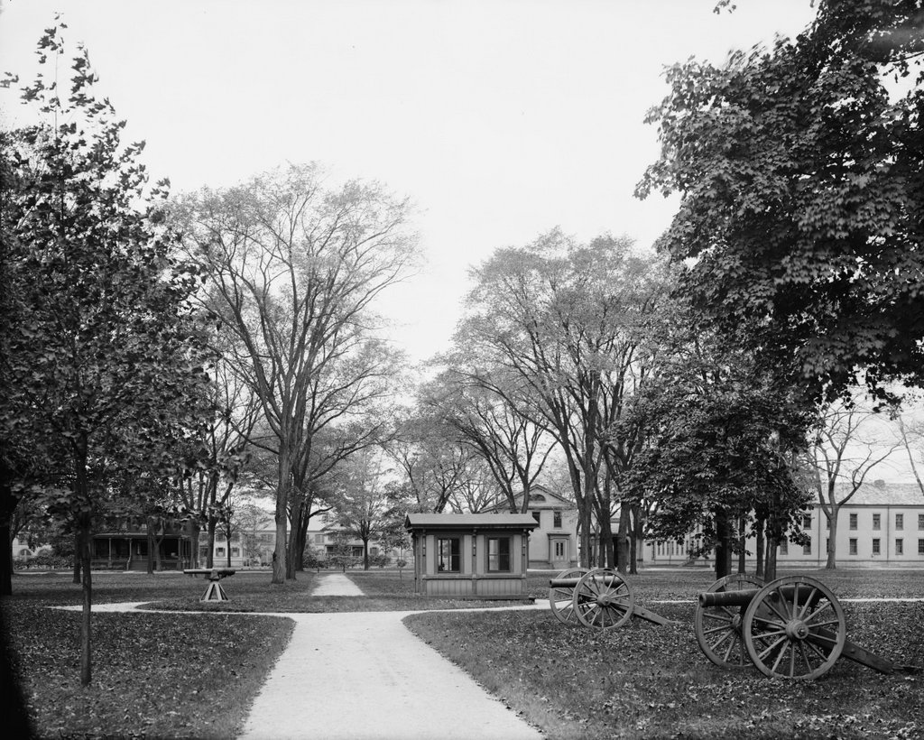
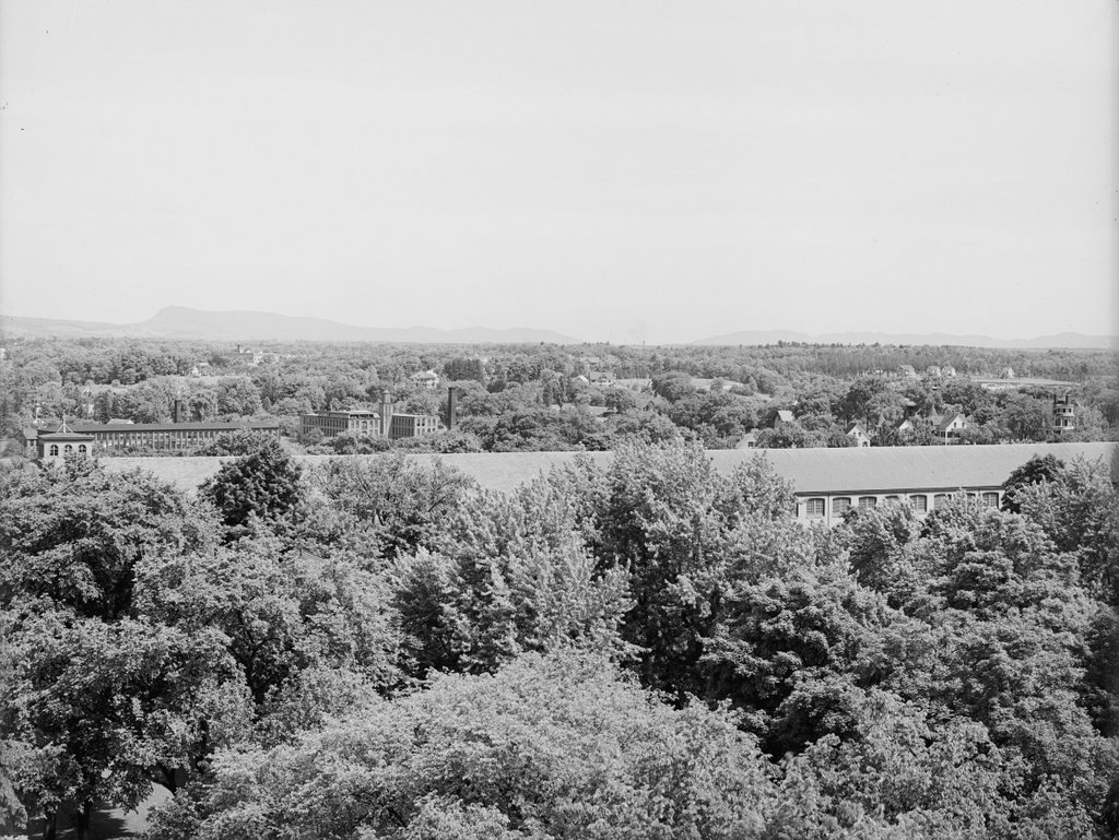
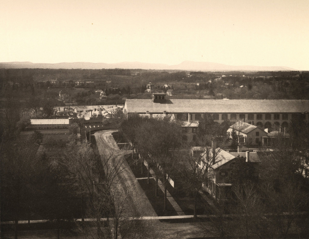
The Main Arsenal at the Springfield Armory, seen from Armory Square around 1892. Image from Picturesque Hampden (1892).

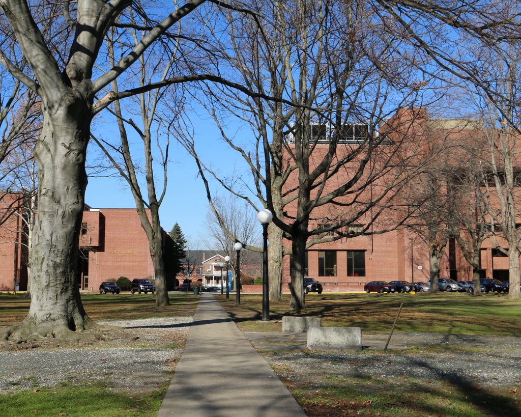
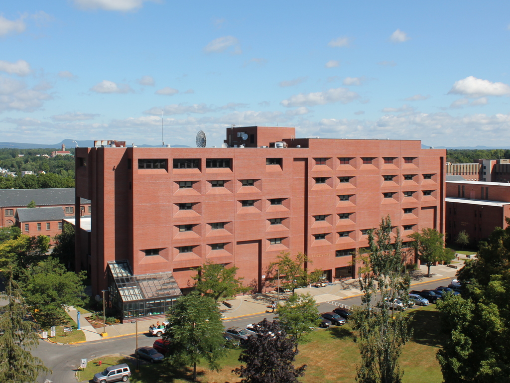
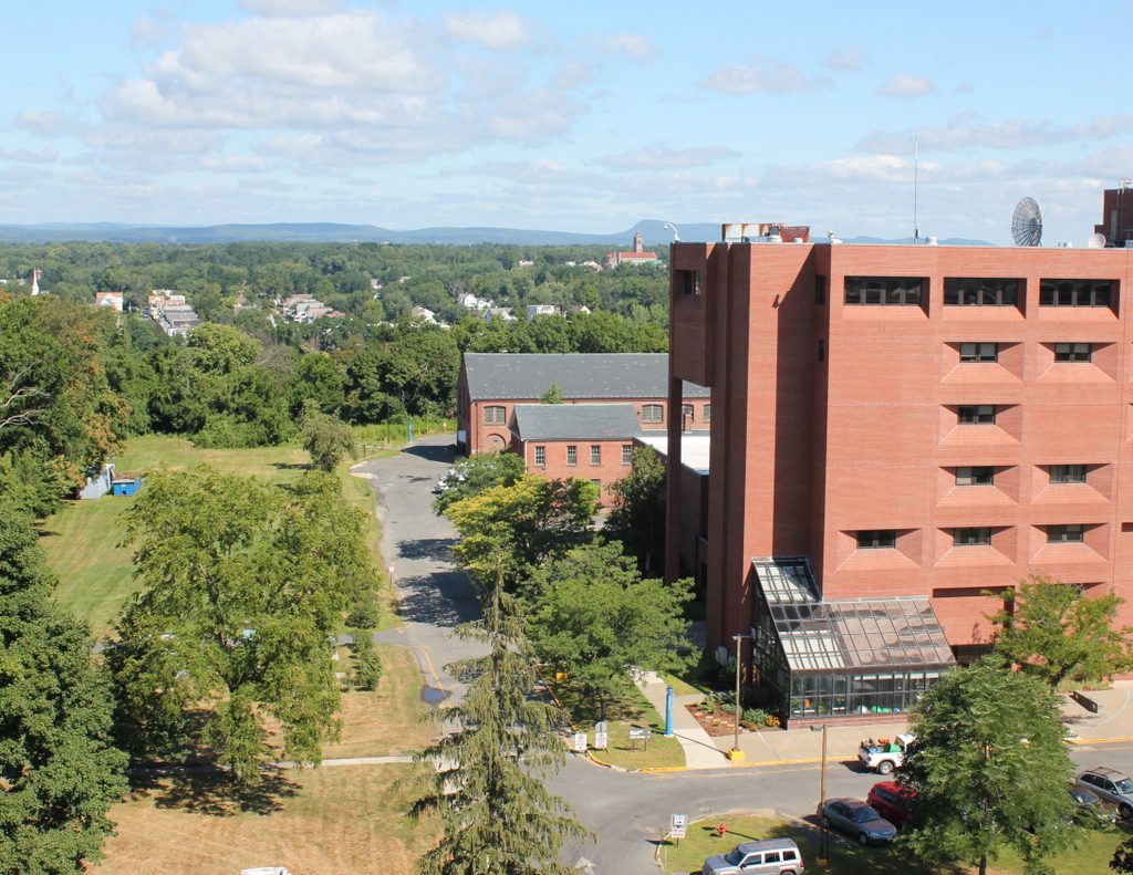
The building in 2018:

The origins of the Springfield Armory date back to 1777, when the Continental Congress established an arsenal here on a bluff overlooking the downtown area of Springfield, on the north side of State Street. The location was ideal, as it was at the crossroads of major trade routes, and it was also upstream of the last rapids on the Connecticut River, which protected Springfield from the threat of British naval attack. General Henry Knox, who had passed through Springfield a year earlier to bring captured cannon to Boston, was a strong advocate of this site, describing it as “perhaps one of the most proper Spots in America on every Account.”

During the American Revolution, the arsenal consisted of a small group of buildings, none of which are still standing, and the facility’s primary purpose was to store and repair weapons, and produce cartridges. After the war, it continued to be used as storage for muskets and powder, and in 1787 it was the scene of the last major battle of Shays’ Rebellion. The rebels had attempted to seize the munitions here, but they were ultimately defeated by a state militia force that assembled to protect the arsenal. However, the event had a significant impact on American history. Occurring only months before the Constitutional Convention, it helped to demonstrate the weaknesses of the Articles of Confederation and the need for a new, stronger national government.

In 1794, Congress authorized two federal armories for the production of small arms, with one in Harpers Ferry, Virginia and the other here in Springfield. This site here on State Street would continue to be the primary facility, but the armory also included several shops along the Mill River, located about a mile south of here. Much of the manufacturing was done at these shops, where the river could be harnessed as a source of power. However, other work was done here on State Street, and this location is also where raw materials and finished firearms were stored.

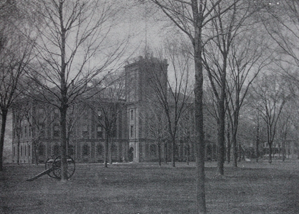
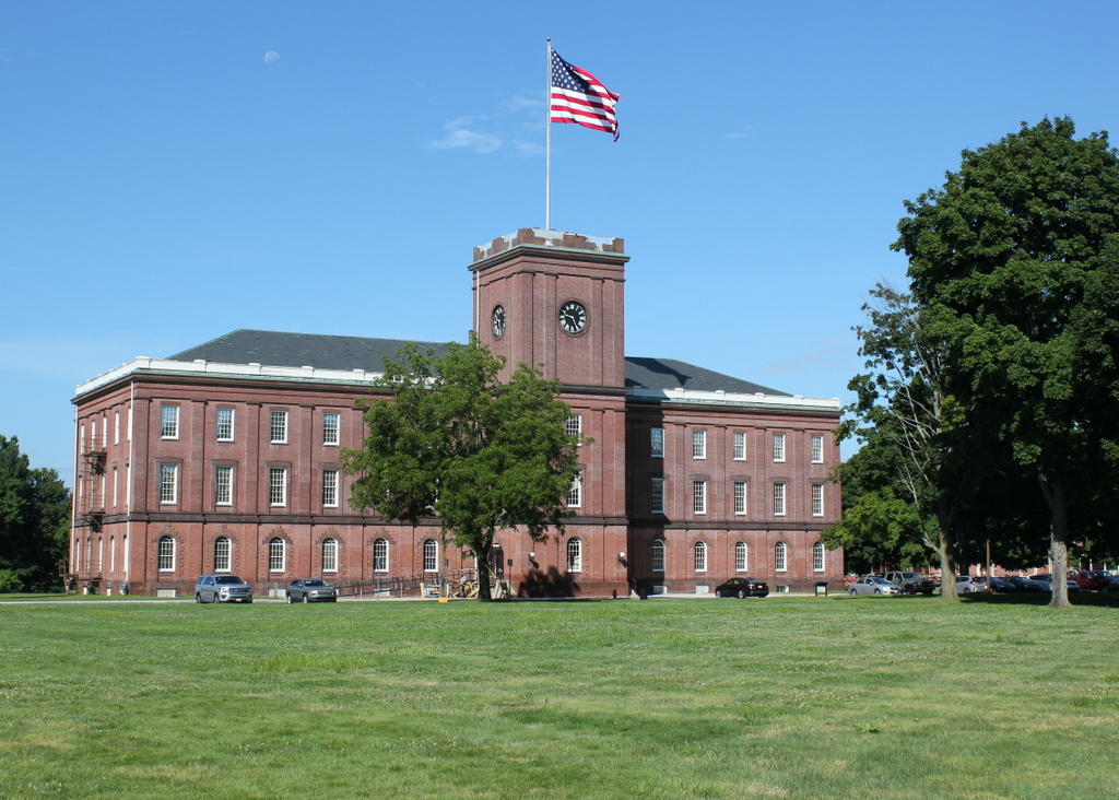
The armory steadily grew during the first half of the 19th century, but the most significant changes came in the 1840s, when superintendent Major James Ripley oversaw a major expansion of the facility. The most notable of these additions was a new main arsenal, which is shown here in these two photos. It was completed in 1850 on the west side of Armory Square, and it could store 300,000 muskets on its three floors. The most notable feature on the exterior of the building is the tower here on the eastern side, which rises 89 feet above the ground level. Because of its location on higher ground above downtown Springfield, the tower has long been a distinctive part of the skyline, and it has become a symbol of Springfield itself, appearing at the top of the city seal since 1852.

In retrospect, Major Ripley’s improvements here at the armory came just in time. By 1850, it was producing over 20,000 guns per year, but this would dramatically increase in 1861, with the onset of the Civil War. That same year, the Harper’s Ferry armory was destroyed, leaving Springfield as the only remaining federal armory. To supply the needs of the Union army, the workforce here increased from 200 to over 2,600, and in 1864 the armory produced over 276,000 rifles. The total output here at the armory during the war was over 800,000 guns, which was more than it had made in the previous 66 years combined.

No Civil War battles occurred anywhere near Springfield, but the armory did survive one threat in 1864, when two would-be saboteurs planted a bomb here in the main arsenal, in the tower near the clock. Despite the fact that the country was in the midst of war, the armory was evidently still open to the public, and two strangers persuaded a reluctant arsenal keeper to bring them up to the top of the tower, supposedly to see the view. Later that night, a watchman found a suspicious bundle near the clock, which had apparently been left by the two men. A subsequent inspection revealed that it had a fuse and was filled with powder, although it probably would not have done much damage to the building even if it had detonated.

The first photo was taken less than 30 years later, in the early 1890s. The armory was still a vital part of the country’s small arms production, and it would remain in use for much of the 20th century. During this time, the facility also played an important role in developing new firearms, including the M1903 and the M1 Garand. The latter was designed by—and named for—John Garand, a Springfield resident who worked here at the armory as a civilian employee. It became the standard-issue Army rifle throughout World War II, and about 3.5 million were produced here in Springfield during the war.

After the war, the armory was used primarily for research and development, with most of the production being outsourced to private contractors. The M14 rifle was designed here during this period, as were other weapons such as machine guns and grenade launchers. However, the facility was ultimately closed in 1968, resulting in a loss of nearly 2,500 jobs.

Following the closure, much of the property was turned over to the state of Massachusetts, becoming the campus of Springfield Technical Community College. The college constructed some new buildings here, and converted the old armory buildings into classrooms and offices. However, the federal government retained control of the western part of the armory, including the main arsenal and the commandant’s house, which stands in the distance beyond the trees on the right side of the scene. Both buildings are now preserved as part of the Springfield Armory National Historic Site, which is run by the National Park Service. As shown in the present-day scene, the arsenal’s exterior appearance has hardly changed since the 19th century, and the first floor of the building is now a museum, housing an extensive collection of firearms and machinery.

Armory Grounds, Springfield, Mass

Looking north on the Armory grounds from near the center of the Green, around 1910-1920. Image courtesy of the Library of Congress, Detroit Publishing Company Collection.

843_1910-1920c loc

The scene in 2015:

843_2015
This view shows part of the same scene as the photos in the previous post, with part of Officers’ Row visible along the north side of the Green. As mentioned there, these houses were demolished in the 1970s to build the current academic buildings for Springfield Technical Community College after the Armory closed. However, several other buildings from the first photo are still standing today, including the Long Storehouse in the distance, which was built in stages between 1846 and 1863. In front of it are several brick Greek Revival style houses that were built in the 1830s as officers’ quarters. Today, these houses are used by several different campus departments, although only the one in the distance near the center of the photo is visible from this angle; the rest are hidden behind the modern campus buildings.

Officers’ Row at the Armory, Springfield, Mass

Facing east on the Armory grounds along Officers’ Row, around 1910-1920. Image courtesy of the Library of Congress, Detroit Publishing Company Collection.

842_1910-1920c loc

The scene in 2015:

842_2015
The Springfield Armory closed in 1968, and most of the grounds are now the home of Springfield Technical Community College, but most of the property has been well preserved as part of the Springfield Armory National Historic Site. However, this area is the exception, as it has undergone significant changes since becoming a college campus. Located along the north side of the Green, these homes for officers were built between the 1830s and the 1890s, but they were demolished in the 1970s to make room for new academic buildings at the college. In the foreground of the 2015 view is Scibelli Hall (1988), with Deliso Hall (1973) and Putnam Hall (1974) in the distance. The only readily visible building from the first photo that still stands today is the former Administrative Building, now named Garvey Hall. This long building on the east end of the Green was built in 1862, and it now functions as the college’s administrative offices.

View from the Arsenal Tower, Springfield, Mass (5)

Another view looking north from the top of the Arsenal at the Springfield Armory, around 1900-1910. Image courtesy of the Library of Congress, Detroit Publishing Company Collection.

841_1900-1910c loc

The view in 2015, photographed with permission from the Springfield Armory National Historic Site.

841_2015
This scene shows the view looking just a little further to the right than this earlier post, and it shows how both the Springfield Armory and the Liberty Heights neighborhood in the distance has changed over the past century. Aside from the Armory’s Long Storehouse in the foreground, the first photo shows sporadic development throughout the area, with the most noticeable buildings being the factories on the left side. The factories were located along Warwick Street, with the Cheney Bigelow Wire Works on the far left, and the Taber Prang Art Company closer to the center. Beyond them, scattered houses illustrate the early stages of development in the Liberty Heights area, with Mount Tom as a backdrop in the distance.

In the 2015 view, the most obvious change is the building in the foreground. The Springfield Armory closed in 1968, and the grounds became home to Springfield Technical Community College. Most of the former Armory buildings were converted into classroom and office space for the college, but there were also a few new buildings that were constructed for the school, including Scibelli Hall, as seen here. Not much is visible in the distance in the 2015 view, but most of the old factories on Warwick Street from the first photo are still standing. One prominent Liberty Heights landmark that was built after the first photo was taken is the Our Lady of Hope Church, which was built in 1925 and can be seen in the distance just to the left of Scibelli Hall.

For other then and now views from the Arsenal tower, see the earlier posts showing the view facing southwest, west, northwest, and south.

View from the Arsenal Tower, Springfield, Mass (4)

The view looking south from the top of the Arsenal tower at the Springfield Armory, around 1882. Image from Springfield Illustrated (1882).

840_1882c spfldillustrated

The view in 2015:

840_2015
This scene in Springfield shows State Street in the foreground, with the South End in the distance. When the first photo was taken, this area on the slope of the hill consisted mainly of single-family homes for upper middle class professionals, who lived on streets like Union, Temple, High, and the lower part of Maple Street. The upper part of Maple Street, barely visible on the far left, was home to many of the city’s wealthiest citizens, and some of these Gilded Age mansions are still standing there today. Further in the distance, the South End was largely a working-class neighborhood, with a number of Italian immigrants moving into the area starting around the time that the first photo was taken.

Over 130 years later, much has changed in this view. As the population grew in the early 20th century, many of the single-family homes along the streets in the foreground were replaced with apartment blocks, as was the State Street Methodist Episcopal Church on the left side of the photo. Located at the corner of State and Myrtle Streets, it was demolished by 1901 to build the large apartment building that still stands there. Today, the only prominent landmark that is visible in both photos is the South Congregational Church, which was built in 1875 at the corner of Maple and High Streets. Another nearby building that opened around the same time was the old high school, which later became a grammar school when Classical High School was built next to it in 1898. The old high school, visible on the extreme right of the first photo, was demolished when Classical expanded in 1922, and Classical High School itself closed in 1986, but the yellow brick building on the far right is still standing after having been converted into condominiums.

For other then and now views from the Arsenal tower, see the other posts showing the view facing southwest, west, northwest, and north.

View from the Arsenal Tower, Springfield, Mass (3)

Looking north from the Arsenal tower at the Springfield Armory, around 1882. Image from Springfield Illustrated (1882).

839_1882c spfldillustrated

The view in 2015, photographed with permission from the Springfield Armory National Historic Site.

839_2015
This view from the top of the Main Arsenal tower shows the northwest corner of the Springfield Armory and the Liberty Heights neighborhood in the distance. Both areas have undergone some significant changes, with the most obvious being the large building to the right. Built for Springfield Technical Community College after the Armory closed in 1968, it occupies the ground where several officers’ houses once stood, as seen in the first photo. However, two other historic buildings in this scene survive today. The Long Storehouse, built between 1846 and 1863, is now partially hidden by newer construction, but it still stands along the northern edge of the campus. Just in front of it, in the center of the photo, is the much smaller Master Armorer’s House, a Greek Revival style home that was originally located next to the Main Arsenal before being moved to its current site shortly before the first photo was taken.

It is somewhat hard to tell, but the Liberty Heights neighborhood in the distance has undergone far more drastic changes than the Armory grounds. When the first photo was taken, this area to the northeast of downtown was sparsely populated, with large estates that were owned by wealthy citizens. However, as the city grew, these properties were subdivided and developed with multi-family homes by the early 1900s. The neighborhood changed even further in the late 1960s and early 1970s, when Interstate 291 was built through the area, but today at least one of the historic mid-19th century homes has survived. Built in 1853, the Joshua Bliss Vinton House is barely visible on the extreme left of the 1882 photo, and it is still standing at the end of Underwood Street, where it serves as the rectory for Our Lady of the Rosary Church on Franklin Street. Both the church and the house are mostly hidden by trees in the 2015 scene, but the steeple of the church can be seen on the far left, and just beyond it is the cupola of the house.

For other then and now views from the Arsenal tower, see the other posts showing the view facing southwest, west, south, and north.