Copley Square, Boston

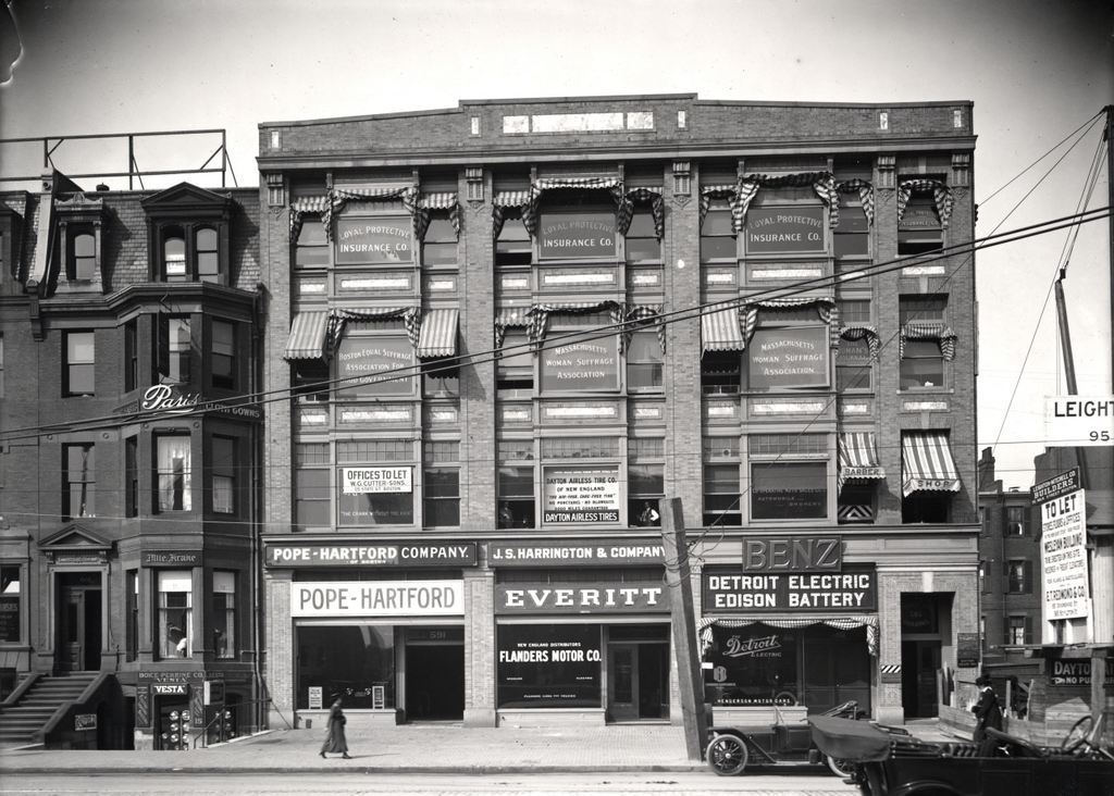
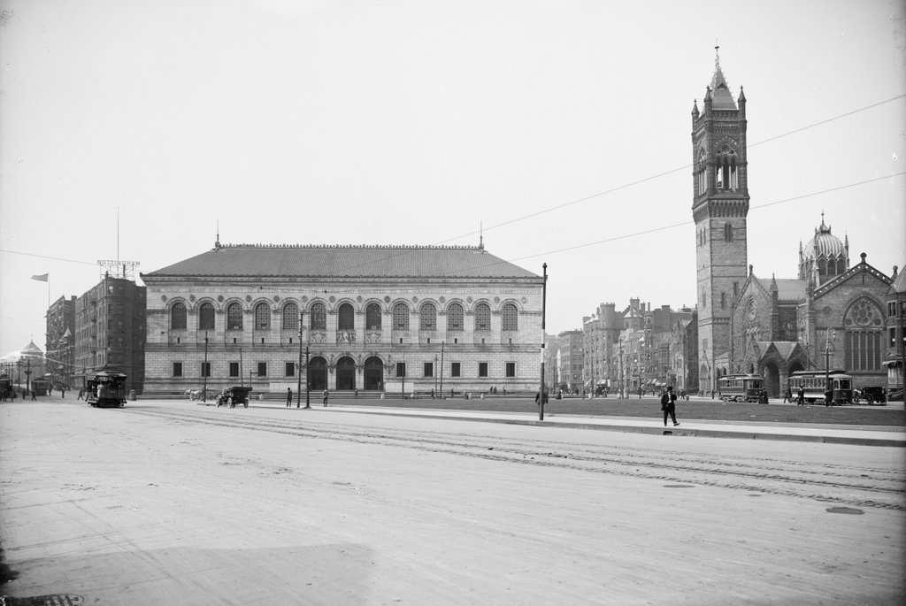
Copley Square as seen from the steps of Trinity Church in Boston, around 1900-1910. Image courtesy of the Library of Congress, Detroit Publishing Company Collection.

675_1900-1910 loc

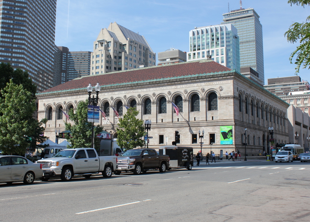
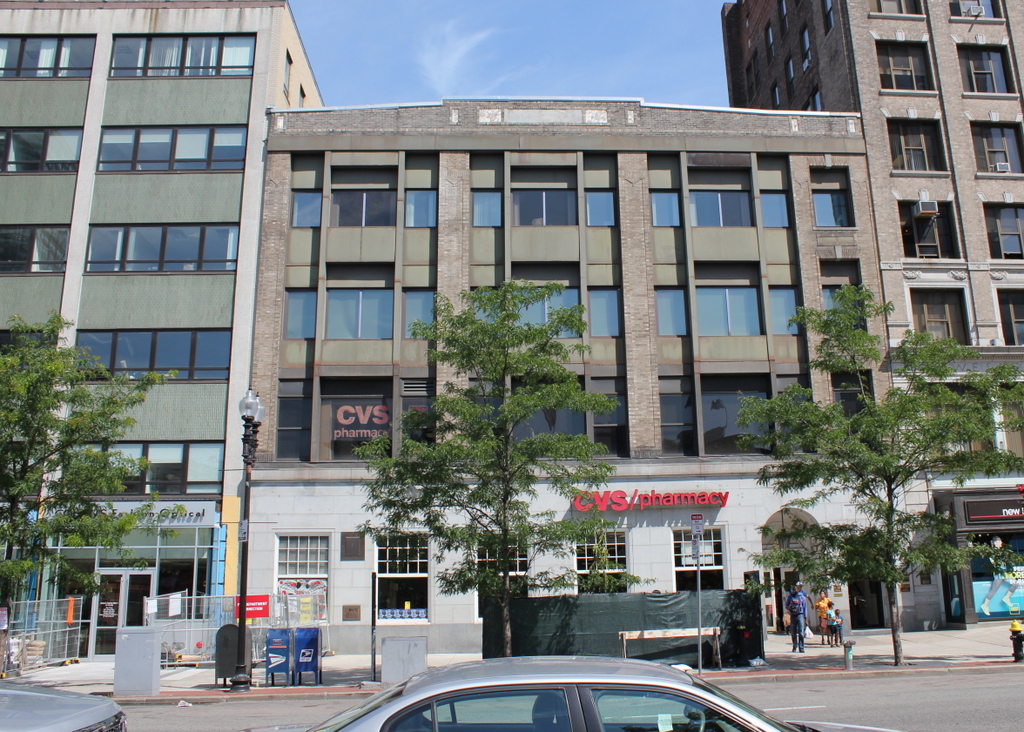
Copley Square in 2015:

675_2015
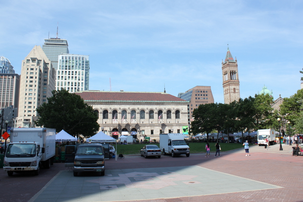
Today, Copley Square is one of the focal points of the Back Bay neighborhood in Boston.  The park is often used for public events, such as the farmers market seen in the first photo.  However, it wasn’t always that way.  In a neighborhood where everything was meticulously planned by 19th century planners and landscape architects, Copley Square as we know it today did not come about until the 1960s.

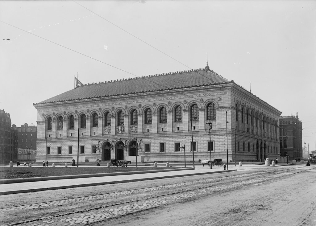
Like the rest of the Back Bay, Copley Square was once just a polluted tidal mudflat, but throughout the second half of the 19th century it was steadily filled, providing the overcrowded city with a new, upscale neighborhood.  As the wealthier citizens moved west, so did many of the city’s major institutions.  Many were located in the vicinity of Copley Square, including Trinity Church, Old South Church, the Museum of Fine Arts, MIT, and later the Boston Public Library.  However, Copley Square itself was originally just a triangular intersection, where Huntington Avenue and Boylston Street met just west of Clarendon Street.

The first photo shows Huntington Avenue crossing diagonally through the square, with a small triangular park on the right.  Originally, even this was not intended to be a park; an atlas from 1874 shows a building on part of the triangle, and the rest of it was divided into housing lots.  Because the Museum of Fine Arts was located here, it was called Art Square until 1883, when it became Copley Square.  The new name was keeping with the art theme, though; it was named for John Singleton Copley, an early American painter from Boston.

The two most prominent buildings in both photos are the Boston Public Library in the center and the New Old South Church to the right.  Completed in 1895 and 1873, respectively, they are two major Copley Square landmarks that have survived largely unchanged.  The only major difference in the buildings is the church tower, which was replaced in the 1930s after the ground under it began to subside, causing a three foot lean at the top of the tower.

The most dramatic change in the two photos is the surrounding neighborhood.  Huntington Avenue now ends at St. James Avenue, so now the square is literally a square.  In the 2015 photo, much of it is in the shadow of the John Hancock Tower, which is located just behind and to the left of where I took the photo.  The background shows some of the other high-rise construction that the Back Bay has seen over the years, including the Prudential Tower, 111 Huntington Avenue, and several other buildings in the Prudential Center complex.

Boston Public Library, Boston

The Boston Public Library’s McKim Building at Copley Square in 1899. Image courtesy of the Library of Congress, Detroit Publishing Company Collection.

674_1899c loc

The building in 2015:

674_2015
This style of Renaissance Revival architecture was common for public libraries in the United States in the early 20th century, but Charles Follen McKim’s design for the Boston Public Library was the first.  It was constructed between 1888 and 1895, and is one of the most architecturally significant library buildings in the country.  It set the stage for similar grand libraries in American cities, including the main branch of the New York Public Library, which opened just over a decade later. Like many of Boston’s other cultural institutions, the library was strategically located in the Back Bay neighborhood, which had gone from polluted tidal marsh to affluent residential neighborhood in less than 50 years. However, one of the challenges in constructing large buildings here was the high water table and the tendency of the filled-in ground to subside.  As a result, the 19th century Back Bay buildings are supported by wooden piles; the library alone has about 4,000  piles that were driven 25 to 31 feet into the ground in the 1880s.

Today, the McKim Building is well-preserved on both the exterior and interior.  The interior includes a grand staircase and the massive Bates Hall reading room, along with a central courtyard, all of which was, as the inscription reads, “dedicated to the advancement of learning.” The main branch of the Boston Public Library has since outgrown the original building, so in 1972 an addition was put on the back, expanding the building to include the entire city block between Dartmouth and Exeter Streets.  Named after its architect, Philip Johnson, this building houses the library’s circulating collections, leaving the original building for the library’s extensive research collections.  Many of these collections are also available online, including a large number of historic photographs on Digital Commonwealth, which has been a great resource for this blog.

The greatest change in this scene, however, is the city around the library.  The section of the Back Bay to the north of Boylston Street has been largely preserved in its original Victorian appearance.  However, to the south of Boylston Street, as seen here, the area has become home to some of the city’s tallest buildings, including the Prudential Tower to the right, the second-tallest in New England after the nearby John Hancock Tower.  Probably the oldest building in the 2015 photo other than the library is the Lenox Hotel, barely visible on the far right beyond the library.  It was built in 1900, so it may have even been under construction when the first photo was taken.

553-567 Boylston Street, Boston

Some buildings on the north side of Boylston Street, between Clarendon and Dartmouth Streets and across from Copley Square, on October 4, 1912. Image courtesy of the City of Boston Archives.

673_1912-10-04 coba

The buildings in 2015:

673_2015
Like the scene a block away in this post, the 1912 photo here shows the transitions that were happening along Boylston Street in the early 1900s.  When the Back Bay was filled in the late 1800s, Boylston Street was, like the other streets in the neighborhood, lined with Victorian brownstone houses.  However, as the street became a major commercial district, the homes were steadily replaced with more modern commercial buildings, with storefronts on the first floor and professional offices in the upper floors.  The 1912 photo shows three of these new buildings, each of which were built within about four years, and each of which had a different automobile company showroom on the first floor.  The only holdout from the earlier era is the four-story rowhouse in the right-center.  It was probably built in the 1870s, and it survived until around 1923, when the present-day building was put in its place.

The three car companies in the first photo were, from left to right: American Locomotive Company (ALCO), American Underslung, and Overland Motor Cars.  Like most early car companies, none of them stayed in business for too long.  ALCO got out of the automobile business just a year later, although one of their managers had been Walter P. Chrysler, who would later go on to establish his own company a little over a decade later.  The other two companies didn’t last much longer than ALCO, and today their former storefronts are occupied by a cafe, a wine store, and a Chipotle restaurant.  The buildings themselves haven’t changed too much aside from the storefronts; the only major change to any of the exteriors is the removal of the cornice on the top of 561 Boylston, the second building from the left.

Chauncy Hall Building, Boston

The Chauncy Hall Building on Boylston Street at Copley Square in Boston, on October 4, 1912. Image courtesy of the City of Boston Archives.

672_1912-10-04 coba

The building in 2015:

672_2015

This building, located at 585-591 Boylston Street across from Copley Square, was probably built within a year or two of the first photo; the MACRIS online database estimates that it was built in 1916, but clearly this is off by a few years if the first photo was taken in 1912.  The first scene shows a wide variety of uses for office space in the building.  Signs in the upper floor windows include two women’s rights organizations: the Massachusetts Woman Suffrage Association, and the less concisely-named Boston Equal Suffrage Association for Good Government (women would get the right to vote nationwide eight years later).  The top floor apparently housed the Loyal Protective Insurance Company, and a barber shop occupied the far right suite on the second floor.

The rest of the building was apparently dedicated to automobiles and automobile parts; signs advertise for the Detroit Electric Edison Battery and Dayton Airless Tires, along with manufacturers ranging from well-known modern brands such as Benz, to long-forgotten ones like the Flanders Motor Company.  Flanders, which occupied the middle storefront, wasn’t in business for much longer than the time it took to take the photo, but according to the lettering on the windows they had both gasoline and electric cars.  At the time, electric cars were just falling out of fashion, and would not reappear again for another century or so.

Today, the Victorian rowhouse to the left is gone, but the Chauncy Hall Building is still standing.  The ground floor has since been heavily altered, and now houses a CVS, but the exterior of the upper floors is still essentially the same from 1912.  One interesting item of note from the first photo, however, is the large “To Let” sign on the extreme right.  The sign advertised for rental space for “stores, floors & offices in the new eight story fireproof Wesleyan Building to be erected on this site.”  The building appears to have been under construction in the 1912 photo, and is still there today to the right of the Chauncy Hall Building.


647-665 Boylston Street, Boston

The buildings from 647 to 665 Boylston Street, between Dartmouth and Exeter Streets, on April 11, 1912. Image courtesy of the City of Boston Archives.

671_1912-04-11 coba

The scene in 2015:

671_2015
The first photo shows a neighborhood in transition.  When this section of the Back Bay was developed in the 1880s, Victorian brownstone rowhouses were predominant along Boylston Street.  However, as the street evolved into a major commercial area, the front steps and bay windows were not well-suited for early 20th century storefronts.  It is hard to tell whether the buildings from the first photo were demolished and rebuilt, or if only the facades were reconstructed, but either way most of the buildings from the 1912 photo would be dramatically altered within the next decade.

There are already some signs of this already happening; the building at 661 Boylston, just to the left of the tall one, is nearing completion in the 1912 photo, with a sign in the window advertising that it will have electric elevators inside.  Three of the other buildings would soon follow, and they were either demolished or radically reconstructed by the early 1920s.  The only surviving brownstone in this scene is the one on the far right, at 647 Boylston.  It was built in 1886, probably around the same time as the other buildings in the first photo, and is located adjacent to the New Old South Church parish house, which is partially visible on the far right of both photos.

This scene is also significant because it shows the location of finish line of the Boston Marathon, in front of the building on the far left.  During the 2013 Boston Marathon bombing, the first explosion occurred just out of view from here, two buildings to the left of the finish line.

777-789 Boylston Street, Boston

A commercial building on Boylston Street, just east of the intersection of Fairfield Street, on April 11, 1912. Image courtesy of the City of Boston Archives.

670_1912-04-11 coba

The building in 2015:

670_2015
Taken three days before the Titanic hit the iceberg and eight days before Fenway Park opened less than a mile away, the first photo shows a building on Boylston Street that appears to ave been some sort of an early parking garage. It was built in 1901, around the same time as the other buildings around it, and the 1912 photo shows a few cars parked inside that are visible through the windows.  Two men are standing on either side of the open garage door, and the sign above the door reads “All cars must come to a stop before entering.”  Today, this view is essentially unchanged.  Their uses are different over a century later, but all of the 1912 buildings are still standing, and unlike the ones in the previous post they have seen only minor exterior alterations.