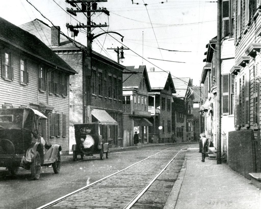
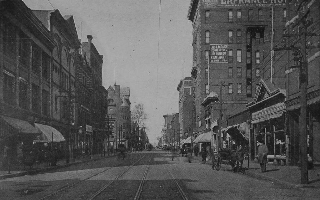
Broadway from Spring Street, Newport, Rhode Island

Looking south on Broadway toward the corner of Spring Street in Newport, around 1885. Image courtesy of the Providence Public Library.
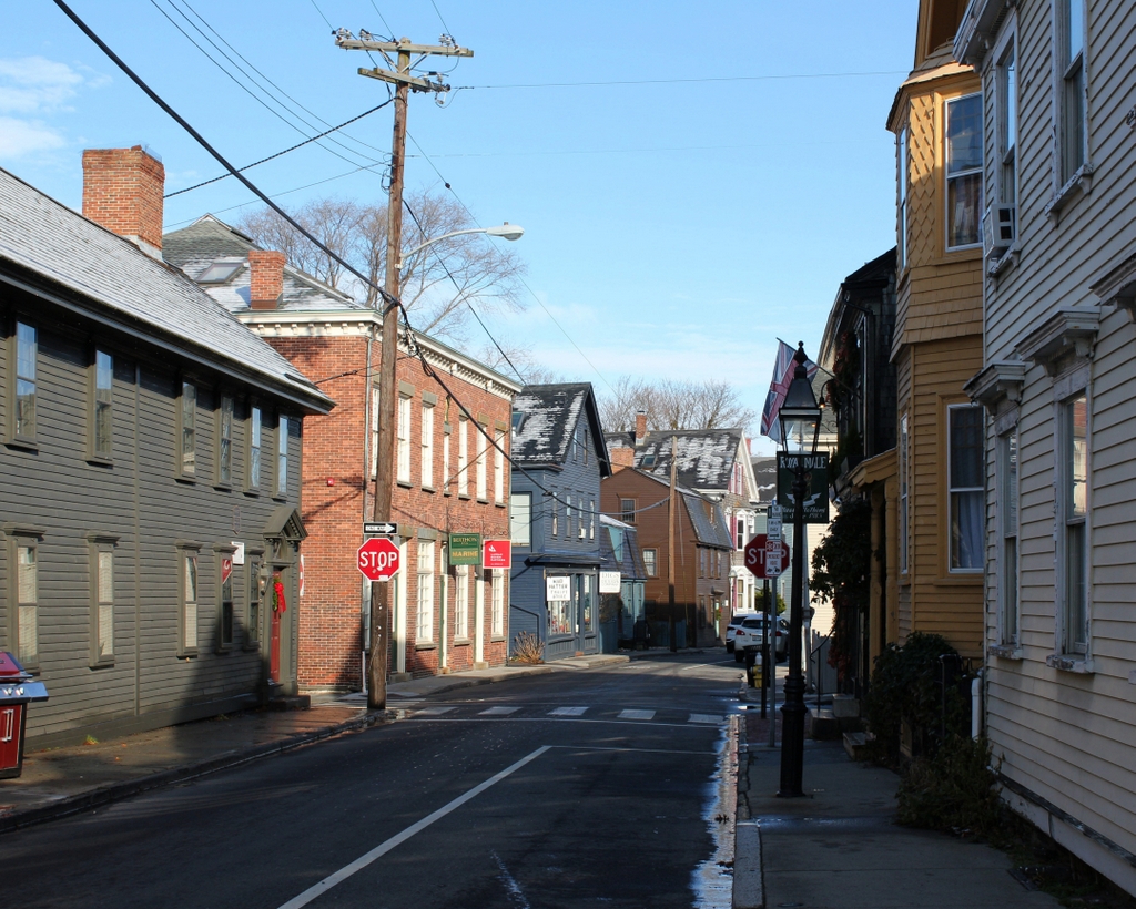
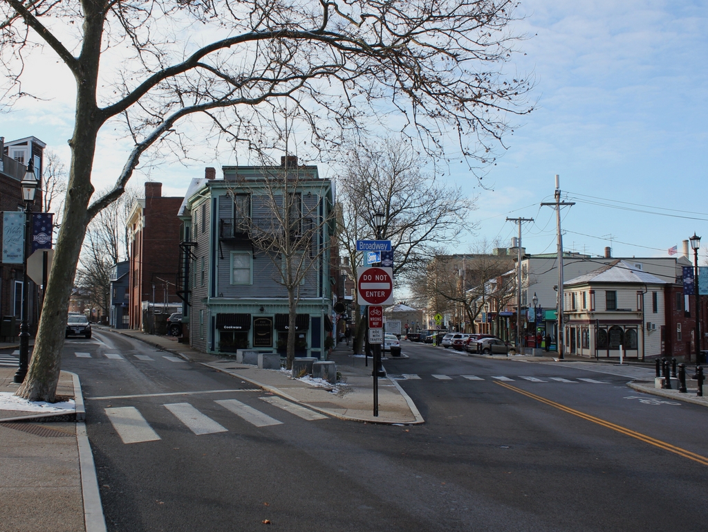
The scene in 2017:

These two photos were taken more than 130 years apart, yet they show remarkably little change. In fact, many of these buildings were already old by the time the first photo was taken. Newport had been a prosperous seaport throughout much of the 18th century, but its economy was hit hard by the American Revolution. Its shipping industry never fully recovered, and the city saw very little growth during the first half of the 19th century. The first federal census, taken in 1790, shows 6,719 residents living here, and over the next 50 years Newport saw only a very modest increase in population, with 8,333 by 1840.

This long period of stagnation hurt Newport’s economy, and there was very little new construction during this time. By the time the first photo was taken around 1885, Newport had reinvented itself as a Gilded Age summer resort, with most of this development occurring to the south of the downtown area. As a result, downtown Newport remained remarkably well-preserved, and it now boasts one of the largest collection of 18th and early 19th century buildings in the country, many of which are visible in this scene.

Along with the buildings themselves, Newport has also retained its colonial-era street network, complete with narrow streets, sharply-angled intersections, and oddly-shaped building lots. These photos show the view looking south on Broadway, at the complex intersection of Broadway, Spring Street, Bull Street, and Marlborough Street. Both Spring Street, to the left, and Marlborough Street, on the extreme right, intersect with Broadway at sharp angles, creating triangular-shaped lots on either side of Broadway.

The narrower of these two lots is on the left, between Broadway and Spring Street. Long before the Flatiron Building was constructed on a similarly-shaped plot of land, a small three-story, wood-frame commercial building was built here. It appears to date back to the late 18th or early 19th centuries, and by the time the first photo was taken it was occupied by Cornell & Son, a grocery store operated by William Cornell and his son Rodman. William also lived here in the building, and the 1880 census showed him here with his wife Sarah and their daughter Ellen.

Today, this scene has not undergone few significant changes, and many of the buildings from the first photo are still standing, including the former Cornell building. Newport remains a popular summer resort, and the storefronts in this scene are now filled with a variety of shops and restaurants that cater to tourists and seasonal residents. Because of its level of preservation, and its high concentration of historic buildings, the downtown area now forms the Newport Historic District, which was designated as a National Historic Landmark in 1968.

High Street from Essex Street, Holyoke, Mass

Looking north on High Street from the corner of Essex Street in Holyoke, around 1910-1915. Image from Illustrated & Descriptive Holyoke Massachusetts.

The scene in 2017:

In the northern part of downtown Holyoke, much of High Street has remained well-preserved, with entire blocks that have hardly been changed since they were developed in the second half of the 19th century. However, this is not the case further to the south, where newer buildings and vacant lots are a more common sight. This block, between Essex and Appleton Streets, has a small group of historic buildings at its northern end, but the southern part of the block, seen here in the foreground, is hardly recognizable from the first photo.

The most prominent building in the first photo is the eight-story LaFrance Hotel, which occupies much of the right side of the scene. It was built in the first decade of the 20th century, and was originally owned by Louis A. LaFrance, a French-Canadian immigrant who became a prominent figure in Holyoke’s real estate and construction business. The LaFrance Hotel was among his most notable properties, and was designed by local architect William B. Reid. It was also among the tallest buildings in the city, towering above the other commercial blocks on High Street, which generally ranged from two to six stories.

Further in the distance, at the corner of Appleton Street, is a pair of six-story buildings that were constructed a few years earlier in the 1890s. The narrower of these two is the red brick McLean Building, and just beyond it is the yellow brick Senior Block, which extends to Appleton Street. Diagonally across from the Senior Block is the turreted YMCA building, which is visible just to the left of the trolley in the distance of the first photo. This was probably the most historically-significant building in the scene, as it was the place where, in 1895, William G. Morgan invented the game of volleyball.

Today, all of the buildings in the foreground of the first photo have either been demolished or altered beyond recognition, and may of the buildings further in the distance are gone as well. Both the McLean Building and Senior Block are still there, but the historic YMCA building across the street was destroyed in a fire in 1943. The LaFrance Hotel, which later became the Essex House, stood here for many years. However, by the early 2000s it was vacant and in poor condition, with bricks regularly falling onto neighboring buildings. It was slated for demolition in 2014, but the process was expedited by a partial collapse that occurred the day before demolition work was scheduled to begin. The rest of the building was subsequently taken down, and the site is now a vacant lot.

High Street from Appleton Street, Holyoke, Mass

Looking north on High Street from the corner of Appleton Street in Holyoke, around 1891. Image from Holyoke Illustrated (1891).

The scene in 2017:

These photos were taken just a block south of the ones in the previous post, and show many of the same buildings in the distance. Closer to the foreground, the first photo shows a row of four-story commercial buildings extending north along High Street, from the corner of Appleton Street. These housed a variety of businesses in the first floor storefronts, with the awnings advertising for goods such as groceries, boots and shoes, and mantles and tiles.

Today, three of the buildings on the right side of the scene are still standing. Furthest to the right, at the corner of Appleton Street, is the P. Curran Block, which was built in 1886. It still retains many of its original details, although the ground floor storefront has been altered, along with the second floor windows on the High Street side of the building. Most significantly, though, it was badly damaged by a fire in 2016, and the two upper floors were still boarded up a year later when the first photo was taken.

Just beyond the P. Curran Block are two other brick buildings that also date back to the 1880s. The older of the two is the one in the middle, at 366-368 High Street. Its ornate brick facade features contrasting limestone trim, and is topped by a metal cornice, both of which are relatively unusual among Holyoke’s 19th century business blocks. The next building, at 358-364 High Street, was built in 1886. It is wider than its neighbors to the right, but has similar architecture, and like the other buildings it remains fairly well-preserved, especially on the exterior of the upper floors.

High Street from Division Street, Holyoke, Mass

Looking north on High Street from the corner of Division Street in Holyoke, around 1910-1915. Image from Illustrated & Descriptive Holyoke Massachusetts.

The scene in 2017:

High Street has been the commercial center of Holyoke since the second half of the 19th century, and it is still lined with a number of historic buildings that date back to this period. This particular block, looking north from Division Street toward Suffolk Street, has not remained as well-preserved as some of the blocks to the north, as shown by the differences between these two photos. However, there are still some surviving buildings from the first photo, particularly in the foreground on the right side.

Starting on the far right, closest to the foreground, is the Guyott House, a hotel that was built in the mid-1880s and was operated by brothers Theodore and Victor Guyott. It occupies a corner lot, and features a small tower that projects slightly above the roofline and outward from the walls. Just to the left of it is a four-story building with an ornate brownstone facade. Built in 1892, it was also owned by the Guyott brothers, and was evidently used as part of the hotel at some point. Although these two buildings have very different exterior designs, they both feature Romanesque-style architecture, and both were designed by noted Holyoke architect George P. B. Alderman.

Further in the distance is a four-story, brick building at 320-322 High Street. It was probably built around the same time as its neighbors to the right, although its architect appears to be unknown. On the left side of this building, in the first photo, is the old central fire station, which was completed in 1864. It was probably the oldest building visible in the first photo, and served as the city’s first central fire station until around 1915, when a new fire station was built on Maple Street. This new building is still standing as the Holyoke Transportation Center, but the old one was demolished soon after the first photo was taken, and the present six-story Young Men’s Hebrew Building was constructed on the site.

Several other buildings on the right side have also since been demolished, including the Cunningham Building, which once stood at the corner of Suffolk Street on the other side of the fire station. However, the left side of the scene has undergone more drastic changes in the century since the first photo was taken. The small two-story building, constructed sometime in the early 1910s, appears to still be there, but not much is left from the 19th century. Perhaps the only relatively unaltered 19th century building along this section of High Street is the Conway Block, which was built around 1885 and still stands in the distance on the southwest corner of Suffolk Street.

High Street from near Dwight Street, Holyoke, Mass

Looking north on High Street, from just south of the corner of Dwight Street in Holyoke, around 1910-1915. Image from Illustrated & Descriptive Holyoke Massachusetts.

The scene in 2017:

The first photo shows the commercial center of Holyoke during the early 20th century, when the city was at the height of its prosperity. Both sides of High Street were lined with commercial buildings, most of which had been built in the second half of the 19th century. They represented a range of architectural styles, and two of the most significant buildings stood in the foreground at the corner of Dwight Street. On the left is the six-story Ball Block, which was built in 1898, and on the right side of the first photo is Delaney’s Marble Block, which was built in 1885 and was designed by noted local architect James A. Clough.

Today, more than a hundred years after the first photo was taken, Holyoke has undergone some significant changes. Much of its manufacturing base was gone by the mid-20th century, and the city has since experienced rising poverty rates and declining population. However, this economic stagnation may have also helped to preserve many of the historic commercial blocks on High Street, since there has been little demand for new developments. Almost all of the buildings are still standing from the first photo, and the only noticeable loss is Delaney’s Marble Block, which was demolished around 1950 to build the present-day two-story building. The buildings in this scene are now part of the North High Street Historic District, which was added to the National Register of Historic Places in 1986.

Main Street, Holyoke, Mass

Looking north on Main Street from near the corner of Dwight Street in Holyoke, around 1891. Image from Holyoke Illustrated (1891).

The scene in 2017:

The first photo shows a row of late 19th century buildings along the east side of Main Street, looking north from near Dwight Street, toward Mosher Street. The buildings represent a mix of architectural styles, but the one that stands out the most is the large, highly ornate Romanesque-style Whiting Street Building in the center of the photo. It was built in 1885 at 32 Main Street, and was owned by the estate of Whiting Street, a prominent Northampton philanthropist who had died a few years earlier in 1878. Around the same time, he also became the namesake of the Whiting Street Reservoir, which opened at the base of Mount Tom in 1888, on land that Street had once owned.

One of the early tenants of the Whiting Street Building was the American Pad and Paper Company, which had been established here in Holyoke in 1888 by Thomas W. Holley. The company, which later came to be known as Ampad, built its business around purchasing scraps from the city’s many paper mills, which were then bound into notebooks and sold at competitive prices. In the process, Holley is said to have invented the first legal pad, a development that, if true, likely would have occurred here in this building.

Early on, American Pad and Paper occupied three rooms here at 32 Main Street, and eventually expanded to eight rooms. The company was here when the first photo was taken in the early 1890s, but around 1895 it moved into a building of its own, at the corner of Appleton and Winter Streets. Over the years, Ampad would go on to become a major producer of pads and other office supplies, and it ultimately outlived nearly all of Holyoke’s other paper mills. The company is still in business today, although not in Holyoke. It is now headquartered in Texas, and it closed its last Holyoke facility in 2005.

In the meantime, this building here on Main Street was subsequently occupied by another writing pad company, the Whiting Street Ruling and Stationery Company. Around 1901, it was renamed the Affleck Ruling and Stationery Company, and was described in a 1905 advertisement in the city directory as “Manufacturers Paper, Pads and Tablets, Paper Rulers and Printers. Mourning Cards and Fine Cards for Engravers.” The company remained here until around 1907, but by the following year it had moved to a new location at 18 North Bridge Street.

Today, more than 125 years after the first photo was taken, none of the buildings from that scene are still standing. The one on the far right was likely the first to go, and was replaced by the present-day building at some point during the early or mid-20th century. Most of the other buildings survived until at least the 1970s, although the Whiting Street Building was destroyed in a fire in 1977. The ones further in the distance were still standing a year later, when they were inventoried as part of the state’s MACRIS database of historic resources, but they have since been demolished, leaving only vacant lots where they once stood.