Old North Bridge, Concord, Mass (2)

The Old North Bridge over the Concord River, with the memorial obelisk in the foreground, around 1900-1906. Image courtesy of the Library of Congress, Detroit Publishing Company Collection.

The scene in 2018:

As discussed in more detail in the previous post, this is the site of the Battle of Concord, a short but significant skirmish between British redcoats and the colonial militia on April 19, 1775. Along with the Battle of Lexington, which had occurred several hours earlier, this marked the beginning of the American Revolution, and it was here at Concord that the British suffered their first fatalities of the war. This was also the first American victory of the war, as it forced the British to abandon their efforts to seize colonial munitions and retreat back to Boston.

The major landmark here at the battlefield was the North Bridge, which crosses the Concord River about a half mile north of downtown Concord. Prior to the battle, the British forces controlled both sides of the bridge, but they ultimately retreated to the east side, here in the foreground of the photo, as a larger colonial force approached from the west. By the time they exchanged fire, the redcoats were standing here on the east bank, while the militiamen were across the river on the west bank.

The original North Bridge was removed in 1788, and it was replaced by a new bridge that stood here until 1793, when the road leading to the bridge was rerouted. For most of the 19th century, there was no bridge here, and the only significant marker on the battlefield was this obelisk, which was installed in 1836 here on the east side of the river. It was dedicated a year later, on July 4, 1837, and the ceremony is best known for the poem “Concord Hymn,” which was written by Ralph Waldo Emerson and sung here during the event. Emerson, who had not yet achieved widespread literary fame at this point, was the grandson of the late William Emerson, the town minister who had witnessed the battle from his nearby house. The poem is particularly remembered for its opening stanza, in which Emerson describes the farmers-turned-soldiers firing “the shot heard round the world” here at the the bridge.

The bridge itself was not replaced until 1874, when a new one was constructed as part of the 100th anniversary celebration of the battle. This also coincided with the dedication of a new monument on the other side of the river, located just out of view beyond the trees on the left side of both photos. Known as The Minute Man, it was designed by sculptor Daniel Chester French, it has since become one of the major symbols of the American Revolution, with its image forms the basis for the United States National Guard logo.

By the time the first photo was taken at the turn of the 20th century, the 1874 bridge had been destroyed and replaced by a new one that was completed in 1888. This one was destroyed in 1909, and a new one was constructed later in the year. The current bridge here was built in 1956, and underwent extensive restoration in 2005. Unlike the earlier bridges, it is intended to be a replica of the original bridge that stood here during the battle.

Today, this area is now part of the Minute Man National Historical Park, a largely linear park that stretches along the route that the British took from Lexington to Concord and back. As a result, the Concord battlefield has remained well-preserved in its colonial-era appearance, with few changes in more than a century since the first photo was taken. The neighboring Old Manse, where William Emerson and his family watched the battle, has also been preserved, and it stands directly behind the spot where this photo was taken.

Old North Bridge, Concord, Mass (1)

The Old North Bridge over the Concord River, with the memorial obelisk in the foreground, around 1906. Image courtesy of the Library of Congress, Detroit Publishing Company Collection.

The scene in 2018:

This view shows the scene looking west across the Concord River, at the site of the Battle of Concord, which occurred on April 19, 1775. Along with a brief skirmish in Lexington earlier on the same day, this battle marked the beginning of the American Revolution, and the site is now marked by several monuments and a replica of the original Old North Bridge that stood here at the time of the battle.

The battle was the result of a British attempt to seize colonial munitions that were stored in Concord. Late on the previous night, a force of some 700 British soldiers under the command of Lieutenant Colonel Francis Smith had left Boston, bound for Concord. This prompted Paul Revere and several other messengers to make their famous midnight ride, warning the minutemen in the surrounding towns. By dawn, the British had reached Lexington, where a group of minutemen had assembled on the Lexington Green. The two sides exchanged fire, the first shots of the war, and the result was eight colonists dead and ten wounded, compared to one British soldier who received a minor wound.

From Lexington, the British continued on their way to Concord, where they began searching for the hidden supplies. Three of the companies ended up here at the North Bridge, which they guarded while other soldiers continued to search. However, by this point the colonial militiamen had begun assembling in a field on the west side of the bridge, visible in the distance on the right side of this scene. This led the outnumbered British to withdraw across the bridge to the east side of the river, here in the foreground. They briefly attempted to tear up the planks of the bridge, but they soon abandoned this effort.

The colonial forces, under the command of Colonel John Barrett, advanced on the bridge from the west, although they were under orders to not fire unless fired upon. Captain Walter Laurie, who commanded the British forces here at the bridge, never gave an order to fire, but some of his men opened fire, killing two militiamen. This prompted the colonists, who were by this point positioned on the west bank of the river, to return fire. In the process, three British soldiers were killed, nine were wounded, and the rest of them began retreating back to the center of Concord. The entire battle took less than three minutes, but it marked the first victory of any kind for the colonists during the war, and the first British fatalities of the war.

This battle would prove to be the only military engagement in Concord during the war, and within less than a year the British forces had evacuated Boston, never again to return to Massachusetts. Here in Concord, life steadily returned to normal after the war, and in 1788 the original North Bridge was demolished and replaced with a new one, evidently without much regard to its historic significance. However, this new bridge did not last very long; it was removed in 1793 when the nearby roads were rerouted.

With the bridge gone, and the old road becoming pastureland, there was little visual evidence of the battle that had occurred here. Probably the first major celebration here at this site came in 1824, on the 49th anniversary of the battle. The event was marked by a parade to the battlefield, and a speech that was delivered here by Ezra Ripley, the pastor of the First Parish Church. He lived right next to here, in a house that later became known as the Old Manse, and his wife Phebe had witnessed the battle from the house, back when she lived here with her first husband, William Emerson.

Despite this celebration, though, it would be more than a decade before the site of the battle was marked by a permanent monument. In 1835, Ezra Ripley donated some of his property here at the spot where the bridge had once stood, and the following year an obelisk, shown here in these two photos, was added to the site. It stood 25 feet in height, and it was designed by Solomon Willard, whose other works included the much larger Bunker Hill Monument in Boston. It was mostly comprised of granite, with the exception of a marble slab here on the eastern face, which reads:

Here on the 19 of April, 1775, was made the first forcible resistance to British aggression. On the opposite Bank stood the American Militia. Here stood the Invading Army and on this spot the first of the Enemy fell in the War of that Revolution which gave Independence to these United States. In gratitude to God and In the love of Freedom this Monument was erected AD. 1836.

The monument was formally dedicated on July 4, 1837, with a ceremony that included a keynote speech by Congressman Samuel Hoar. However, the event is best remembered for “Concord Hymn,” a poem that was sung here. It was written for the occasion by Ralph Waldo Emerson, the grandson of William Emerson, and it was among his earliest notable literary works. Although he would later be known primarily as an essayist and founder of the Transcendentalism movement, the poem remains perhaps his single best-known work, particularly the opening stanza:

By the rude bridge that arched the flood,
Their flag to April’s breeze unfurled,
Here once the embattled farmers stood,
And fired the shot heard round the world.

At the time, there was still no bridge here, and it would be several more decades before one was finally reconstructed. This ultimately occurred in 1874, in advance of the 100th anniversary of the battle. As part of this project, a new bridge was designed and a new monument was dedicated on the west side of the river, marking the militiamen’s position during the battle. This monument, visible in the distance of both photos, features a bronze statue designed by noted sculptor Daniel Chester French. Known as The Minute Man, it consists of a colonial militiaman leaving behind a plow and carrying a musket, representing the farmers who came to the defense of their country. Beneath the statue is a pedestal, designed by James Elliot Cabot, with the first stanza of Emerson’s poem inscribed on it.

The 1874 bridge was destroyed in a storm in 1888, and it was subsequently rebuilt. This bridge, which is shown in the first photo, stood here until 1909, when it too was destroyed. The next bridge here was a concrete structure, completed later in 1909, and it survived until 1955 before being severely damaged by a flood. Its replacement, which was built in 1956, is still standing today, although it underwent a major restoration in 2005. Unlike the earlier bridges, it is a replica of the original one, and it has remained here at this site for longer than any of its predecessors.

In 1959, the bridge, the monuments, and the surrounding battlefield became part of the Minute Man National Historical Park, which encompasses a number of historic sites relating to the battles of Lexington and Concord. The park gained significant attention during the American bicentennial celebrations, and in 1975 President Gerald Ford gave a speech here at the bridge to commemorate the 200th anniversary of the battle. Today, under the administration of the National Park Service, this scene has remained well-preserved, with few significant changes since the first photo was taken more than a century ago. The site of the battle continues to be a major tourist destination, and the park as a whole draws upwards of a million visitors each year to Lexington and Concord.

Union Station, Springfield, Mass (2)

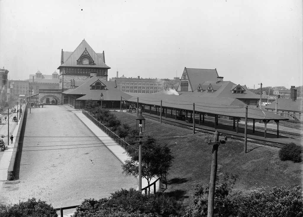
The old Union Station in Springfield, seen from near the corner of Lyman and Chestnut Streets around 1900-1910. Image courtesy of the Library of Congress, Detroit Publishing Company Collection.
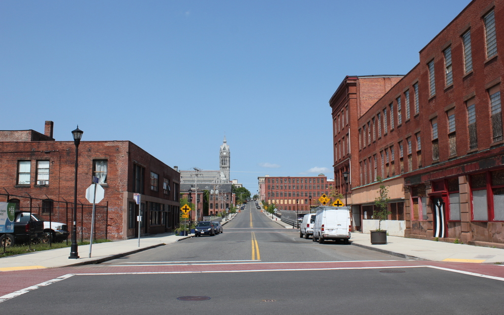
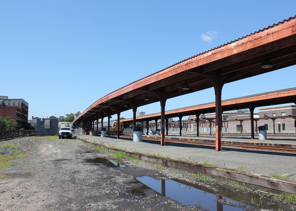
The scene in 2018:

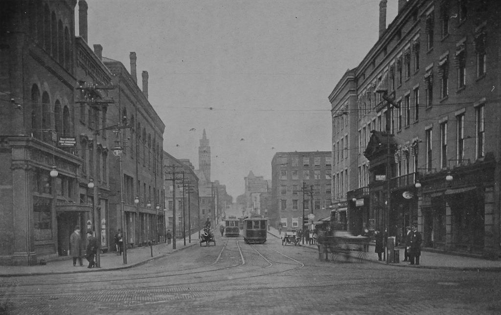
The first photo shows Union Station as it appeared about 10 to 20 years after its completion, as seen looking west from near Chestnut Street. The photo in a previous post shows the south side of the station from Lyman Street, but this view provides a more elevated look at the station, showing both the north and south sides, along with the platforms in between. Further in the distance, beyond the station on Main Street, are two of the city’s leading hotels: the Massasoit House on the far left at the end of Lyman Street, and Cooley’s Hotel, which can be seen in the center of the photo.

This area has been the site of Springfield’s primary railroad station since 1839, when the Western Railroad arrived, linking Springfield with Worcester and Boston. The original station, which was located on the west side of Main Street, burned in 1851, and the following year it was replaced by a brick and iron, shed-like station on the same spot. This station served for most of the second half of the 19th century, but it began to cause problems as the city grew in population and as rail traffic increased. Because the station was located at street level, trains had to cross directly over Main Street, leading to significant delays for traffic on the street. The station itself was also becoming insufficient for the number of trains that passed through here, and by the late 1860s there were already calls for a new station and elevated tracks through downtown Springfield.

In 1869, the state legislature authorized such a project, but it would take another 20 years before it was actually finished, thanks to an impasse between the city government and the Boston & Albany Railroad, which was the successor to the old Western Railroad. This dispute centered around which side was responsible for paying to raise the tracks and lower the grade of Main Street, and it ultimately did not get resolved until 1888, when the railroad agreed to spend around $200,000 to raise the tracks, while the city would spend about $84,000 to lower Main Street by four feet.

This compromise enabled the station project to move forward, and the old station was demolished in the spring of 1889. The new one was completed in July, and it was located on the east side of Main Street, which provided more room for the station. It featured a Romanesque Revival-style design, and the original plans had been the work of noted architect Henry H. Richardson, who designed many of the stations along the Boston & Albany Railroad. He died in 1886, though, and his successor firm of Shepley, Rutan & Coolidge subsequently modified the plans for the Springfield station.

One of these changes proved to be a serious design flaw. Richardson had intended for a single station building, located on the south side, with a large train shed over the tracks. However, the Connecticut River Railroad, which would share the union station with the Boston & Albany and the New York, New Haven & Hartford Railroads, objected to this plan, wanting a separate building on the north side. As a result, the finished station consisted of two buildings, each with its own ticket offices and waiting rooms, and four tracks in between them. The smaller northern building, on the right side of this scene, served northbound and westbound travelers, while the larger building on the south side was for those heading southbound and eastbound.

Within less than 20 years, this design was already causing problems as Springfield continued to grow. Having two different station buildings was an inefficient use of space, since it meant redundant facilities such as the waiting rooms. This was also a source of confusion for passengers, who would sometimes find themselves at the wrong ticket office or platform. In addition, the two buildings prevented the railroads from adding new tracks, since the space in between was already filled with four tracks and three platforms.

Aside from practical considerations, the architecture of the building was also obsolete by the early 20th century. Romanesque Revival had been widely popular during the last two decades of the 19th century, particularly for public buildings, and railroad stations were seen as important architectural showcases. They were usually the first thing that a traveler saw in a particular city, so any self-respecting city need a monumental station, in order to give a good first impression to visitors. This may have been the case for Union Station in the 1890s, but Romanesque Revival had fallen out of favor by the next decade, and the new generation of iconic railroad stations – such as Grand Central and Penn Station – began to feature classically-inspired Beaux-Arts designs.

As early as 1906, it was evident that the station was inadequate. That year, the Springfield Republican published an article on the city’s numerous railroad-related problems, observing that “[t]he most important problem as far as the safety and convenience of the public is concerned is the rebuilding of the union station.” In 1921, the newspaper was even more explicit, remarking on how “there seems to be, in fact, a nearly unanimous demand that the structure be cast to the scrapheap,” and four years later it declared that the station was “long execrated for its combination of discomfort, dinginess and danger.”

The station’s demise was hastened by a November 1922 fire that caused about $25,000 in damage to the north building. The fire was considered to be suspicious, but its origins were unclear, with the railroad superintendent simply telling the Republican, “your guess is as good as mine.” The city’s fire chief declared that he found no evidence of arson, although he did not actually inspect the cellar beneath the waiting room, where the fire had apparently started. There were no injuries, and most of the valuables, including mail, packages, and cash, were safely removed by railroad employees and by an off-duty police officer.

Within less than a month of the fire, the railroad had approved the plans for a new station. This replacement would be in approximately the same location, but the entire station would be located on the north side of the tracks. It would be connected to Lyman Street on the south side by way of a tunnel beneath the tracks, and this tunnel would also provide access to the platforms, avoiding the dangers of passengers crossing directly over the busy tracks. Perhaps most significantly, the number of tracks would be increased from four to 11, reducing congestion and delays on the railroad.

Demolition on the old station began in 1925, just 36 years after it was built, and the new Union Station opened the following year. It would remain in use for the next few decades, but passenger rail began to experience a significant decline throughout the country during the post-World War II era. With passenger trains becoming unprofitable for railroads to operate, Amtrak ultimately took control of the country’s passenger rail services in 1971. Two years later, most of Union Station was closed except for the Lyman Street entrance, and a small Amtrak station was built on the south side of the tracks.

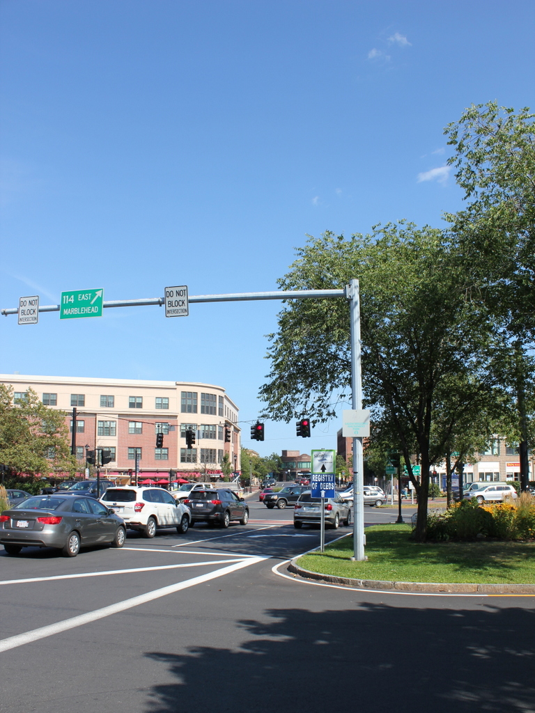
Union Station sat empty for many years, and only one of the old station platforms was used for passenger service. However, the building underwent a major restoration in the 2010s, reopening in 2017. It now features a ticket office, waiting area, and retail space in the concourse, along with office space on the upper levels, including the offices of the Peter Pan Bus Lines. Union Station is also the terminus for most of the city’s PVTA bus lines, with 18 bus berths just to the west of the station. In addition to this, the rail traffic here at the station has also increased. Along with a number of daily Amtrak trains, Union Station is also served by the Hartford Line, which opened in 2018 with commuter trains running from Springfield south to New Haven.

The 2018 photo shows this scene about a year after the station reopened. An Amtrak train is visible in the distant center of the photo, consisting of two passenger cars pulled by a P42DC diesel engine. This is the typical setup for most of the Springfield to New Haven Amtrak trains, and the rear car is a converted Metroliner cab car, which allows the train to be operated in either direction without turning the locomotive. Just to the right of the train is Platform C, which was the last part of the station’s renovation project. It was still unfinished when the first photo was taken, but this project – which upgraded the platform to modern accessibility requirements – was finished in January 2020, marking the end of Union Station’s restoration.

Dwight Street from Main Street, Holyoke, Mass

Looking west on Dwight Street from the corner of Main Street in Holyoke, around 1910-1915. Image from Illustrated & Descriptive Holyoke Massachusetts.

The scene in 2017:

This scene shows a view similar to the one in an earlier post, but these photos were taken a little further back, showing the entire block of Dwight Street between Main and Race Streets. The first photo here, taken around the early 1910s, shows a busy Dwight Street, with a mix of trolleys, automobiles, and what appears to be a blurry horse-drawn carriage. On the right side of the photo is the Hotel Hamilton, which was built in 1850 and expanded and renovated in 1889-1890. Among its ground-floor tenants at the time was the Mechanics Savings Bank, which occupied the storefront on the far right side, at the corner of Dwight and Main Streets. Another bank, the Hadley Falls National Bank, was located directly across the street, in the building on the far left side of the first photo.

Another important building in the first photo was Parsons Hall, the third building from the left side of the photo. Also known as the Chapin Block, it was apparently built around the early 1850s, about the same time as the hotel across the street. Its large third floor, which took up about half the building’s height, housed an auditorium that was used for a variety of events throughout the 19th century. Several local churches, including the Unitarian Church and the French Congregational Church, temporarily worshiped here before constructing buildings of their own, and high school graduations were also held here for many years. The actress Eva Tanguay, a French-Canadian immigrant to Holyoke, made her stage debut here as a young girl in the 1880s, before going on to have a successful career as one of the most famous vaudeville performers in the country.

Further up the street, the first photo shows several of Holyoke’s factory buildings. On the left, just beyond Parsons Hall on the other side of the Second Level Canal, was the mill of the Beebe & Holbrook Paper Company. It was built in the early 1870s as the Hampden Paper Company, but later became Beebe & Holbrook in 1878. Then, in 1899, it became a division of the American Writing Paper Company. This trust included many of Holyoke’s paper mills, and controlled a significant portion of the nation’s writing paper supply. However, other Holyoke mills remained independent, including the Whiting Paper Company, whose mill is visible on the other side of Dwight Street, just beyond the Hotel Hamilton. Further in the distance, hidden from view in the first photo, was the William Skinner & Sons silk mill, and at the top of the hill was Holyoke City Hall, with its tower rising above the factories.

Today, there are still some identifiable buildings from the first photo, but most have undergone significant changes. Some of the Beebe & Holbrook buildings are still standing, but the one that is most visible in the first photo is gone. Similarly, several of the former Whiting buildings are also still there, but not the one shown in the first photo. Closer to the foreground, the Hotel Hamilton building now stands vacant. It was dramatically altered after the hotel closed in the early 1940s, including the removal of most of the fourth floor. Most of the storefronts have also been altered, except for the former Mechanics Savings Bank on the far right side, which still retains its early 20th century appearance.

On the other side of the street, Parsons Hall similarly lost its upper floor during the mid-20th century, and much of its Dwight Street facade was also rebuilt. However, the rest of the building is still standing in its heavily-altered appearance. Its neighbors to the left are gone, though, including the former Hadley Falls National Bank building and the site is now an empty lot at the corner of Main Street. Overall, the only building that has survived from the first photo without any significant changes is city hall itself, which still stands in the distance at the corner of Dwight and High Streets, and remains in use as the seat of the municipal government.

Canal Street, Holyoke, Mass

Looking southwest on Canal Street, toward the corner of Lyman Street in Holyoke, in 1936. Image taken by Lewis Hine, courtesy of the U. S. National Archives.

The scene in 2017:

The first photo was taken by the prominent photographer and social reformer Lewis Hine, who is best known for his early 20th century work with the National Child Labor Committee. However, later in life he also documented life across the country during the Great Depression, including a visit to Holyoke in 1936. At the time, the city was a leading producer of paper and textiles, and most of his photos focus on Holyoke’s industry. This photo shows the scene along Canal Street, with the Second Level Canal on the right. The Boston and Maine Railroad crosses through the middle of the photo, and in the background is the Whiting Paper Company, which was located in a building that had previously been occupied by the Lyman Mills. Hine’s original caption provides a short description of the photo:

Mt. Holyoke [sic]Massachusetts – Scenes. An old mill of absentee ownership, liquidated and sold at a great bargain to a new owner, who would not sell or rent, uses only a small part; railway transportation; electric power transmission. Lyman Mills (Now Whiting Company), 1936

The Lyman Mills company was incorporated in 1854, in the early years of Holyoke’s industrial development. It was located in the area between the First and Second Level Canals, on the south side of Lyman Street, and over the years its facility grew to include a number of mill buildings. The earliest of these, not visible from this angle, were built in 1849-1850, and were originally used by the Hadley Falls Company before being acquired by Lyman Mills. Other buildings, including the large one in the distance on the right side of the scene, were added later in the 19th century, and the company became a major producer of textiles. It also employed a significant number Holyoke residents, including many of the city’s French Canadian immigrants, and by the turn of the century it had a workforce of over 1,300 people.

However, as Hine’s caption indicates, the Lyman Mills corporation was liquidated in 1927. Although still profitable despite increased competition from southern manufacturers, the shareholders were evidently more interested in selling the company’s assets instead of continuing to operate it as a textile mill. Over a thousand employees were put out of work on the eve of the Great Depression, and the property was sold to the Whiting Paper Company, whose original mill was located directly adjacent to the Lyman Mills complex.

Founded in 1865 by William Whiting, this company went on to become one of the largest paper manufacturers in the country, and Whiting enjoyed a successful political career as mayor of Holyoke and as a U. S. Congressman. After his death in 1911, his son, William F. Whiting, took over the company and oversaw the expansion into the former Lyman Mills buildings in the late 1920s. The younger Whiting was a longtime friend of Calvin Coolidge, and in August 1928 Coolidge appointed him as the U. S. Secretary of Commerce, replacing Herbert Hoover, who would be elected president a few months later. Whiting served in this role for the remainder of Coolidge’s presidency, until Hoover’s inauguration on March 4, 1929.

The conversion of the Lyman Mills into paper production, along with Whiting’s brief tenure as Secretary of Commerce, occurred just a short time before the stock market crash of October 1929. By the time the first photo was taken seven years later, the country was still in the midst of the Great Depression. Like the rest of the country, Holyoke was hit hard by the Depression, but the Whiting Paper Company managed to survive and remain in business for several more decades. However, Holyoke continued to see economic decline throughout the mid-20th century, with most of its major manufacturers closing or relocating, and the Whiting Paper Company finally closed in 1967, just over a century after it had been established.

Today, however, this scene has hardly changed in more than 80 years since Lewis Hine took the first photo. Although no longer used to produce textiles or paper, the Lyman/Whiting complex is still standing in the distance, and has been converted into a mixed-use property known as Open Square. Closer to the foreground, the same railroad bridges still carry the tracks over Canal Street and the Second Level Canal, and even the transmission towers are still standing, although they do not carry any electrical wires anymore.

Railroad Station, Salem, Mass

The railroad station at the corner of Washington and Norman Streets in Salem, around 1910. Image courtesy of the Library of Congress, Detroit Publishing Company Collection.

The scene in 2017:

Salem was a prosperous seaport throughout the 18th and early 19th centuries, with a fleet of sailing ships that brought goods to the city from around the world. Given its location on the north shore of Massachusetts, it was heavily dependent on the sea for its commerce, but in 1838 the first railroad line was opened to Salem, connecting the city to East Boston by way of the 13-mile-long Eastern Railroad. The line initially ended here in Salem, at an earlier station on this site, but in 1839 it was extended north to Ipswich, and then to the New Hampshire state line the following year.

The 1838 railroad station was built at the southern end of downtown Salem, meaning that the extension of the line would have to pass directly through the center of the city. In order to accomplish this, the railroad dug a 718-foot tunnel directly underneath Washington Street, allowing trains to pass through without disrupting downtown Salem. The incline for the tunnel began immediately north of the station, just out of view to the left of this scene, and it re-emerged just north of present-day Federal Street. The 1917 book The Essex Railroad, by Francis B. C. Bradlee, provides a description of the 1839 construction of the tunnel:

In order to build it the old Court House, together with stores and other buildings standing south of Essex street, were demolished. Washington street was laid open throughout its entire length and a wide ditch was dug, much trouble being experienced from the sandy nature of the soil. Residents on the side of the street boarded up their house fronts and moved away for some weeks. The sidewalks were piled with gravel. A stone arch was built in the open ditch, and when this was finished the gravel was back-filled as far as possible and the surface restored. Three air holes surrounded with iron railings came up from the tunnel through the street for ventilation, but when the locomotives began to burn coal they were done away with. All this work was done on the most elaborate plans and models, it being considered one of the largest pieces of granite work ever undertaken up to that time in New England.

The original railroad station was used until 1847, when it was replaced by the one in the 1910 photo. It was designed by prominent architect Gridley J. F. Bryant, with a castle-like appearance that included two large crenellated towers on the north side of the building, as seen here. Trains passed directly through the building, and under a granite arch between the towers that resembled a medieval city gate. The interior originally included three tracks, and the upper level of the station housed the offices for the Eastern Railroad, including those of the president and the superintendent.

The station was badly damaged by an April 7, 1882 fire that started when a can of flares exploded in one of the baggage rooms. The wooded portions of the building were destroyed, but the granite exterior survived, and the rest of the station was soon rebuilt around it. Then, in 1884, the Eastern Railroad was acquired by its competitor, the Boston and Maine Railroad, and the station became part of a large railroad network that extended across northern New England. The first photo, taken around 1910, shows the a side view of the front of the building, with the original granite towers dominating the scene. In the lower left, a locomotive emerges from the station, while railroad flagmen – barely visible in front of the train – warn pedestrians and vehicles on the street.

In 1914, much of the area immediately to the south of the station was destroyed in a catastrophic fire that burned over a thousand buildings. The station itself survived, though, and remained in use for more than a century after its completion. However, it was demolished in 1954 in order to extend the tunnel south to its current entrance at Mill Street. By this point, intercity passenger rail was in a serious decline, due to competition from automobiles and commercial airlines, and the replacement station was a much smaller building on Margin Street, just south of the new tunnel entrance.

The 1950s station was used until 1987, when the present-day station was opened at the northern end of the tunnel, at the corner of Washington and Bridge Streets. Salem is no longer served by long-distance passenger trains, but it is now located on the MBTA Newburyport/Rockport commuter rail line, and trains still pass through the tunnel that runs underneath Washington Street. On the surface, though, there are no recognizable landmarks from the first photo, and today the scene is a busy intersection at the corner of Washington and Norman Streets. The former site of the historic station is now Riley Plaza, a small park that was dedicated in 1959 and named in honor of John P. Riley (1877-1950), a Salem resident who was awarded the Medal of Honor for his service in the Spanish-American War.