Westminster Street from Eddy Street, Providence, RI

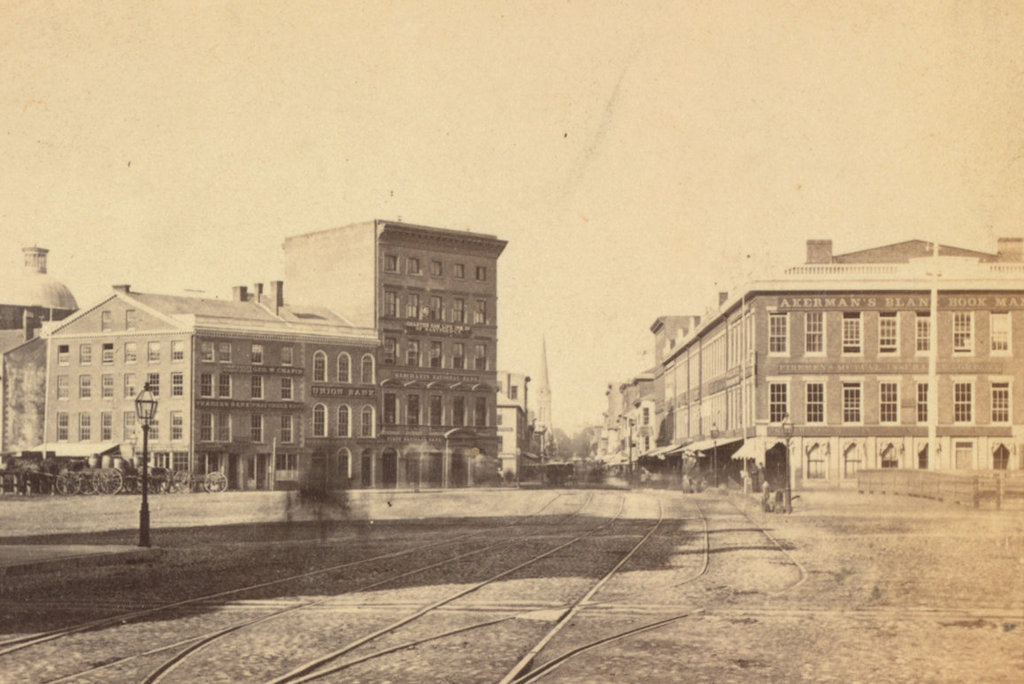
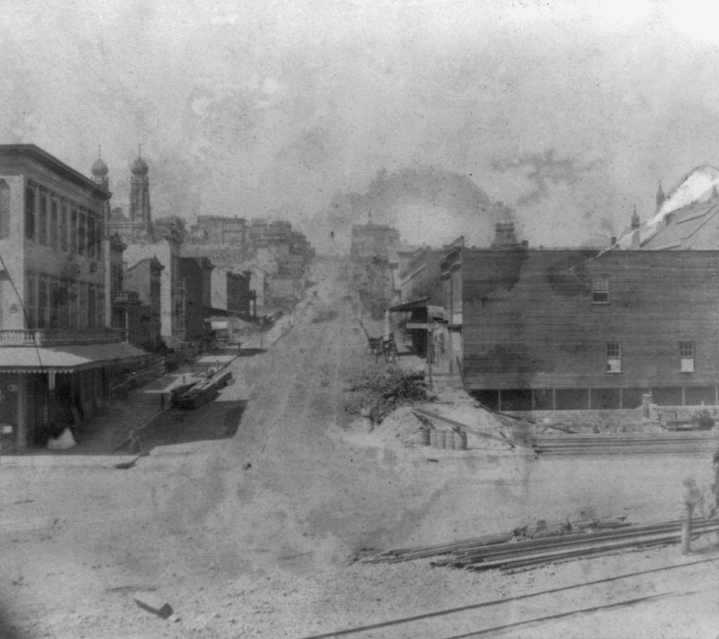
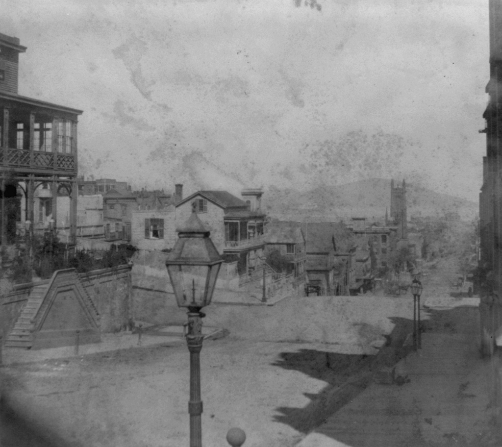
Looking west on Westminster Street from Eddy Street in 1865. Image courtesy of the New York Public Library.

1071_1865-nypl

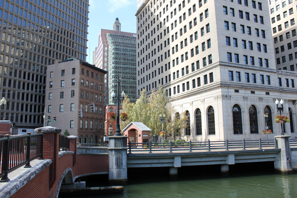
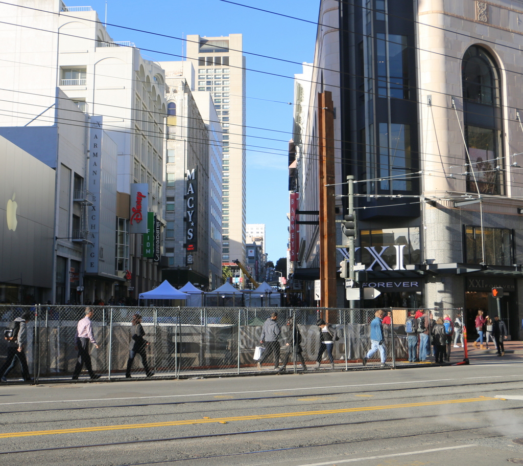
Westminster Street in 2016:

1071_2016
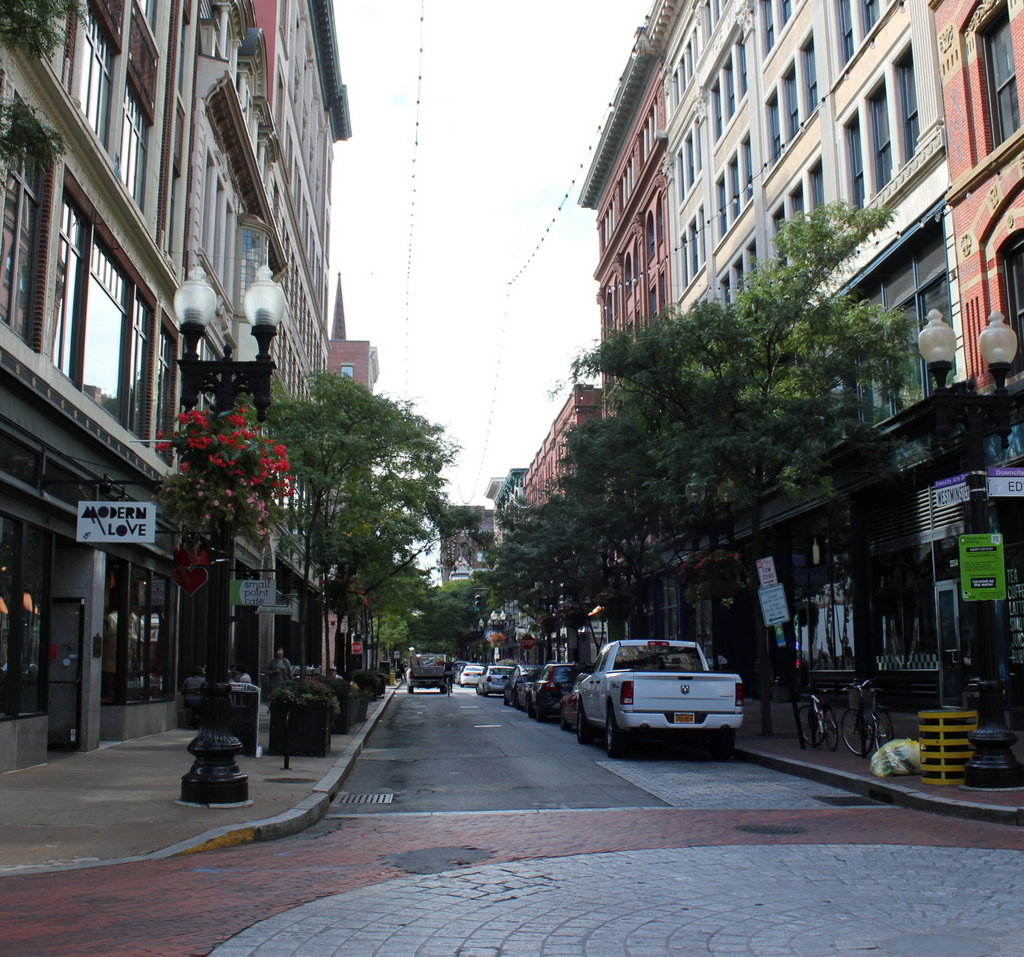
Taken over 150 years apart, these two views both show Westminster Street as a busy commercial center in downtown Providence. The camera’s exposure time for the first photo was too long to capture the pedestrians and vehicles passing by, but their blurred streaks give the impression of a bustling, fast-paced scene. Today, the scene is crowded with vehicles of a different kind, and almost nothing is left from the first photo. Most of the buildings here today date back to the 19th century, but they were built a decade or two after the first photo was taken. Because of this, the 1865 photo gives a glimpse of the street as it appeared before it was completely altered by developments of the 1870s and 1880s.

The first photo was taken the same year that the Civil War ended, and in the postwar years Providence experienced a dramatic population increase. For most of the 19th century, the city’s population had been doubling roughly every 20 years. This trend continued after the war, with the city growing from just over 50,000 in 1860 to over 100,000 in 1880, and then to over 200,000 by the first decade of the 20th century. In the process, street scenes like the one here on Westminster Street were changed, with the plain early 19th century buildings giving way to larger, more elegant ones of the Victorian era.

The most prominent building in the first photo is the First Universalist Church, on the right side at the corner of Union Street. It was built in 1825, designed by Providence architect John Holden Greene to replace the previous church on the same site, which had burned down earlier in the year. The congregation was still meeting here 40 years later when the first photo was taken, but in 1872 they moved to their current building on Washington Street. Soon after, the old church was demolished and replaced with one of the commercial blocks on the right side of the 2016 photo.

Today, none of the commercial buildings from the first photo survive. The oldest one is the red brick building at 239 Westminster Street, visible in the upper right center of the photo. Although it was altered later in the 19th century, the oldest part of the building dates to 1866. On the other side of the street, visible directly behind the lamppost, is the Burgess Building. Completed in 1870, this is the oldest one in the present-day scene that remains relatively unaltered. None of these are old enough to have appeared in the first photo, though. The only building of any kind that is still standing from the 1865 scene is Grace Church, visible a few blocks away on the right side of the street. This Gothic Revival church was designed prominent architect Richard Upjohn and completed in 1846, and although it is mostly blocked from view in the present-day scene, the top of its spire can still be seen in the distance.

Westminster Street, Providence, RI

Looking southwest on Westminster Street from the bridge over the Providence River, in 1865. Image courtesy of the New York Public Library.

1060_1865-nypl

The scene in 2016:

1060_2016
One of the main commercial streets in downtown Providence is Westminster Street, which begins here at the College Street Bridge and continues southwest through downtown Providence and toward the Federal Hill neighborhood. When the first photo was taken, this area consisted primarily of low-rise brick commercial buildings, some of which dated as far back as the early 19th century. The oldest was probably the Union Bank Building on the left, which dated back to 1816. Just to the right of it is Merchants Bank Building, completed in 1857, and on the other side of Westminster Street is part of the large Washington Building, which was built in 1843. Also partially visible in this scene is the 1857 Customhouse, whose dome can be seen in the distance on the far left.

Today, this streetscape has completely changed. Only the Merchants Bank Building remains, now seeming oddly out of place. It has actually gained an additional floor in the intervening years, but despite this it is still completely dwarfed by modern skyscrapers, being literally overshadowed by its neighbor to the left. The Union Bank Building is long gone, as is the Washington Building, which died a slow death in the late 19th and early 20th centuries. It was partially demolished around 1889 to build a Romanesque building for the Rhode Island Hospital Trust Company. Both this new structure and the remainders of the old one were demolished by 1919, when a new, much larger building was completed for the company on the same site. This building is still standing, dominating the right side of the 2016 photo, but it is now owned by the Rhode Island School of Design as part of their campus. The only other survivor from the first photo is the Customhouse building. It is hidden behind modern buildings, but is still standing on Weybosset Street and is in use as a courthouse.

Lost New England Goes West: Old Saint Mary’s Cathedral, San Francisco

Old Saint Mary’s Cathedral at the corner of California Street and Grant Avenue in San Francisco, around 1856. Image courtesy of the DeGolyer Library, Southern Methodist University.

897_1856c smu

The church around 1866. Image courtesy of the Library of Congress, Lawrence & Houseworth Collection.

897_1866c loc

The church in 2015:

897_2015
As mentioned in earlier posts, San Francisco of the 1850s was very different from just a decade earlier. When gold was discovered in California in 1848, its population was just a thousand, but by the early 1850s it had jumped to over 30,000, and was rapidly growing. To accommodate the number of Catholics, the city’s first cathedral was built here in 1854, and the building has stood here ever since. At the time, it was located near the fringes of the city, near Chinatown and some of the notorious red light districts, which explains the “Son, Observe the Time and Fly from Evil” inscription just below the clock.

The first photo was taken before the steeple was completed, but by the early 1860s the church looked essentially the same as it does today. It served as the cathedral for the Archdiocese of San Francisco until 1891, and since then it has been a parish church. In 1906, it was one of the few buildings in the area to survive the earthquake, which did no serious structural damage to it. However, the earthquake started fires that gutted the building, so today the only original part of the church is the brick exterior.

The surrounding Chinatown neighborhood was rebuilt after the fires, and today it is home to the largest Chinese population in the world outside of Asia. This section of Grant Avenue in particular is a major tourist attraction, and Old Saint Mary’s Cathedral remains both an active church and also a major landmark that dates back to the city’s early years as a Gold Rush town.

This post is part of a series of photos that I took in California this past winter. Click here to see the other posts in the “Lost New England Goes West” series.

Lost New England Goes West: Stockton Street, San Francisco (2)

Looking north on Stockton Street from Market Street in San Francisco, in the early 1860s. Image courtesy of the Library of Congress, Lawrence & Houseworth Collection.

895_1866c loc

The scene in 2015:

895_2015
The southern end of Stockton Street is here at Market Street, which has been the commercial center of San Francisco since it was first laid out a few years before the first photo was taken. The photo was possibly taken in 1860, because the scene in the foreground appears to show the construction of the Market Street Railway, a horse-drawn trolley system that opened here in 1860. Today, the trolley system is still in place, although this line now operates historic electric streetcars rather than their horse-drawn predecessors.

Today, this section of San Francisco in the vicinity of Union Square is a major shopping district. Nothing is left from the original photo; most of the small two and three story buildings were probably gone before the turn of the 20th century, and anything that would have been left would have been destroyed in the 1906 earthquake. The two photos do have at least one thing in common, though – as in the 1860s view, the 2015 scene also shows a major public transit program in the works. As of 2016, San Francisco is building the Central Subway here, underneath Fourth Street and Stockton Street. The city does not have much in the way of true rapid transit lines, and this subway, which is scheduled to be completed in 2018, will provide much-needed service to the South of Market and Chinatown neighborhoods.

This post is part of a series of photos that I took in California this past winter. Click here to see the other posts in the “Lost New England Goes West” series.

Lost New England Goes West: California Street, San Francisco (2)

Looking east down California Street in between Grant and Stockton Streets in San Francisco, in 1863. Image courtesy of the Library of Congress, Historic American Buildings Survey Collection.

894_1863c loc

California Street in 2015:

894_2015
When the first photo was taken, the United States was in the midst of the Civil War, and although the bulk of the fighting was some 2,000 miles away, California nonetheless contributed to the Union war effort. Thanks to the Gold Rush about 15 years earlier, San Francisco was a prosperous, rapidly-growing city, and much of this gold was used to fund the Union army. Although southern California had a substantial number of Confederate sympathizers at the time, the northern part of the state, including San Francisco, was predominantly pro-Union, and provided a number of soldiers who went east to fight.

After the Civil War, San Francisco’s prosperity continued, and this section of California Street in the distance became the city’s Financial District. However, the entire area was destroyed in the 1906 earthquake and the resulting fires that spread across the city, and only a few buildings in this scene survived. The photo in this earlier post, taken from the base of the hill facing up California Street, shows some of the destruction.

The most notable survivor from the 1863 photo here is the Old Saint Mary’s Cathedral on the left, at the corner of Grant Avenue. Built in 1854, it withstood the earthquake itself, but was gutted by the fires that left only the brick walls standing. The interior was rebuilt in 1909, and the church is still standing today as a prominent landmark in the city’s Chinatown neighborhood.

This post is part of a series of photos that I took in California this past winter. Click here to see the other posts in the “Lost New England Goes West” series.

Lost New England Goes West: Stockton Street, San Francisco

Looking north on Stockton Street from California Street in San Francisco, around 1866. Image courtesy of the Library of Congress, Lawrence & Houseworth Collection.

893_1866c loc

Stockton Street in 2015:

893_2015
When the first photo was taken, most of the buildings in the scene were still fairly new. San Francisco did not see dramatic population growth until the 1849 gold rush, and most of this area was probably developed in the mid to late 1850s. However, everything here was destroyed in the fires after the 1906 earthquake, and in 1914 the street itself underwent some major changes when the Stockton Street Tunnel was built. This tunnel starts here directly underneath the foreground, and it carries traffic two and a half blocks through the hill, while the original street still goes up and over the hill. Today, Stockton Street is one of the two main streets in Chinatown, along with Grant Avenue, and this section in the distance of the photo is the neighborhood’s primary commercial center.

This post is part of a series of photos that I took in California this past winter. Click here to see the other posts in the “Lost New England Goes West” series.