Memorial Hall, Monson, Mass

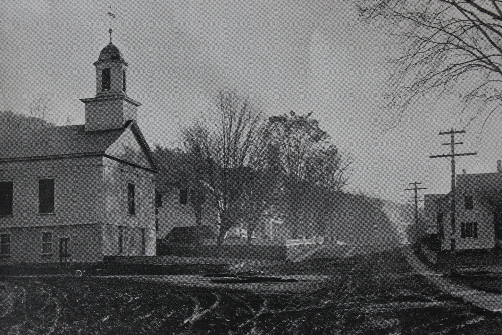
Memorial Hall on Main Street in Monson, around 1892. Image from Picturesque Hampden (1892).
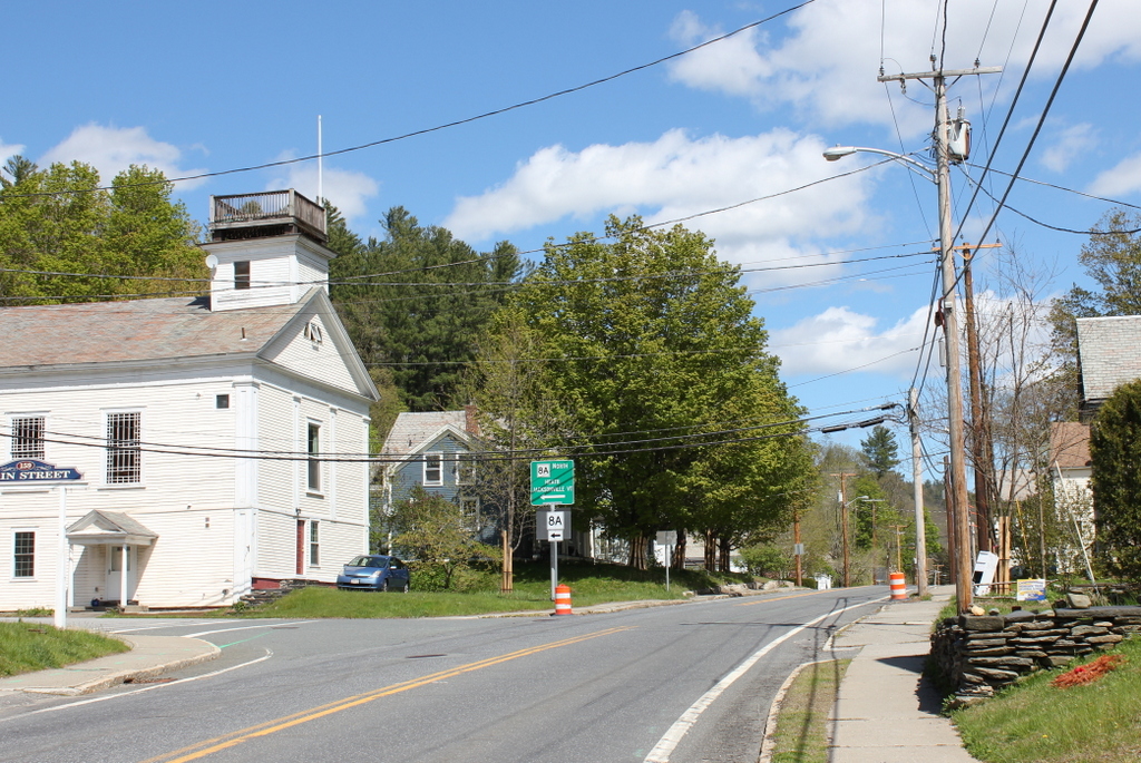
The scene in 2020:

One of the most architecturally-impressive buildings in Monson is Memorial Hall, which was completed in 1885 as a town hall and a memorial to the town’s residents who served in the Civil War. Prior to this time, Monson did not have a purpose-built town hall; instead, town meetings were held at the First Church and the Methodist Church. It was at one of these town meetings, in 1883, that Rice M. Reynolds offered to donate land and money to help construct a new town hall. Together with his brother Theodore and their father, prominent local industrialist Joseph L. Reynolds, the family gave $17,000 towards the project, with the town covering the remaining $42,000 in construction costs.

The late 19th century was the heyday for Civil War monuments in New England, and almost every city or town had at least one to recognize its residents who fought for the Union. Here in Monson, the town had two major memorials. The first of these was the Soldiers’ Monument in front of the First Church, which was donated by Cyrus W. Holmes and dedicated in 1884. Memorial Hall followed a year later, and together these two monuments honored the 155 Monson residents who served in the war. Of these, sixteen were killed in battle, and thirteen died of disease during the war.

Memorial Hall was designed by architect George E. Potter, and it was constructed with granite that was quarried in the town by the William N. Flynt Granite Company. It features a Gothic-inspired design with an asymmetrical main facade. On the left side, at the northwest corner of the building, is a 100-foot tower, and on the right, in the southwest corner, is a 45-foot turret that is topped by a statue of a soldier. Most Gothic and Romanesque-style public buildings of this era were built with multi-colored exteriors, using either contrasting light and dark bricks or sandstone. This was not as easy to do with gray granite blocks, but there are were some efforts to create contrast, particularly with the alternating light and dark stones in the arches above the doors.

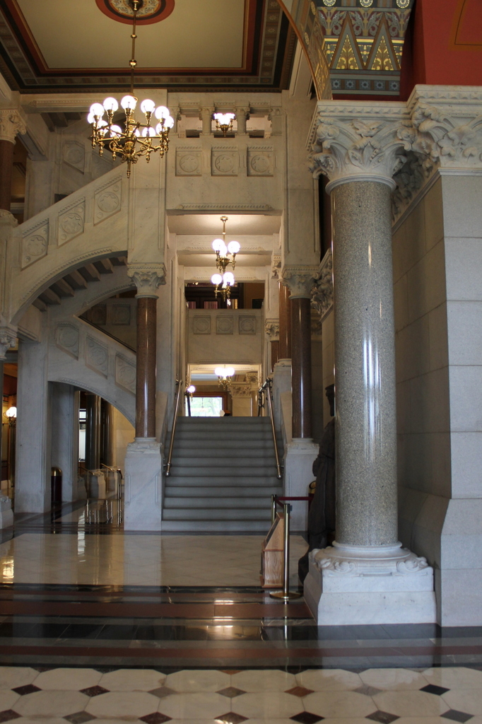
On the interior, the largest space in the building was the auditorium on the first floor. It had a capacity of a thousand people, and could be used for town meetings and other civic events. The building also included offices for town officials such as the town clerk, the selectmen, the assessor, and the superintendent of schools. In the basement was the town lockup, along with utility and storage space, including the town safe.

The second floor was originally occupied by the Marcus Keep Post of the Grand Army of the Republic. The GAR was a prominent and politically-powerful fraternal organization in the North during the late 19th century, and its membership was comprised exclusively of Union veterans of the Civil War. Here in Monson, the local chapter of the organization was named for Marcus Keep, a town resident who died from infection in 1864 after being wounded in the leg during a skirmish in Virginia. Along with the regular GAR post, the second floor space was also used by the Woman’s Relief Corps and the Sons of Veterans, the two main auxiliary organizations of the GAR.

Memorial Hall was completed in mid-1885, and the first public event to be held here was, appropriately enough, a service in memory of Ulysses S. Grant, who had died on July 23. Then, on August 15, the building was formally presented to the town at the first official town meeting here in Memorial Hall. The occasion was marked with little ceremony, and only about 50 voters attended the meeting. Rice M. Reynolds spoke on the reason for its construction, and then the chairman of the building committee, Edward D. Cushman, presented it to the voters, who accepted it.

The first photo was taken less than a decade after the building opened. Since then, remarkably little has changed here in this scene. Memorial Hall continued to be used as the town hall until 1992, when the town offices moved a few blocks north to the old high school building at the corner of Main and State Streets. The town still owns Memorial Hall, though, and it is now used for concerts, plays, fairs, and other community events.

As shown in the present-day photo, the exterior has remained well-preserved throughout this time, and even the 19th century homes on either side of it are still standing, although the one on the left was significantly expanded around 1910. Because of its historic and architectural significance, Memorial Hall was added to the National Register of Historic Places in 1984, and in 1991 it became a part of the Monson Center Historic District, which is also listed on the National Register.

Main Street, Charlemont, Mass

Looking east on Main Street from the corner of North Heath Road in the center of Charlemont, around 1891. Image from Picturesque Franklin (1891).

The scene in 2020:

These two photos show the scene looking east on Main Street in the center of Charlemont. The town is situated along the Deerfield River, and this valley serves as the primary east-west route through the northern Berkshires. Charlemont was settled in the mid-1700s, and today the town features a number of historic buildings from the late 18th and early 19th centuries, some of which are visible here in this scene.

On the far left side of the scene is the former Charlemont Methodist Church. The exact origins of this building seem murky, with various sources listing it as having been built in 1840, 1820, or 1770. Regardless of its actual date of construction, it was originally built elsewhere in Charlemont, and it served as the town’s Unitarian church. However, this congregation subsequently disbanded, and in 1861 the Methodists purchased it to replace their own church building, which had been destroyed in a fire. They then moved the former Unitarian building to this site on Main Street. Prior to the move, they built the ground floor to house social rooms, and then placed the church on top of this structure.

Aside from the church, the first photo shows a number of houses on both sides of Main Street. Most feature modest Greek Revival-style designs, and they were likely constructed around the mid-19th century. One of the largest of these houses is the one in the center of the scene, just to the right of the church, which appears to have been enlarged several times during the 19th century. The main section of the house has two stories, and on the left is a one-story ell extending toward the church. There is another one-story addition in the rear of the house, which is connected to a barn.

The 1871 county atlas lists this house as the home of Robert R. Edwards, a local manufacturer who ran a small factory in Charlemont that produced scythe snaths. During the 1870 census, he was 52 years old and living in the town with his wife Lydia, presumably here at this house. At the time, his real estate was valued at $4,000, along with $1,000 for his personal estate, so his total net worth was somewhat higher than that of most of his neighbors. By 1879, his factory employed six workers, and produced a thousand snaths per week. Aside from his business, he served on the board of trustees for the neighboring Methodist Church, and he was also on the town’s library committee. He died in 1910 at the age of 92, so it seems plausible that he was still living here in this house when the first photo was taken.

The first photo depicts the scene here in Charlemont shortly before the dawn of the automobile age. Within just a few years, early “horseless carriages” would begin to make their appearances on the streets. One of the challenges for these pioneering motorists, though, was the generally poor condition of America’s roads. As shown in the first photo, Charlemont’s Main Street was a muddy dirt road, with plenty of ruts left behind by many horse-drawn wagons.

Because of conditions like these, by the early 20th century Massachusetts began upgrading its road network, including the creation of the Mohawk Trail, which was formally designated in 1914. This scenic route, which still exists today as the western part of Massachusetts Route 2, links the northern Connecticut River Valley with the northern Berkshires. Main Street in Charlemont became part of this route, and the town center is the approximate midpoint between Greenfield and North Adams.

Today, notwithstanding the upgrades to the road, this scene has remained well-preserved more than 125 years after the first photo was taken. The center of Charlemont retains much of its historic character, and many of the buildings in the first photo are still standing, including Robert Edwards’s house and the Methodist Church. The church building has undergone significant interior changes, having been converted into a house in the 1960s, but its exterior is mostly the same, aside from the missing belfry. Both the church and the house, along with the other surrounding buildings, are now part of the Charlemont Village Historic District, which was added to the National Register of Historic Places in 1988.

Florida Baptist Church, Florida, Mass

The Florida Baptist Church, seen looking north on Church Road in Florida, around 1893. Image from Picturesque Berkshire (1893).

The scene in 2020:

The origins of the name of Florida, Massachusetts are murky, but there seems to have been a certain level of irony to it, since the town has little in common with its southern namesake. Located high in the Hoosac Range of the northern Berkshires, just south of the Vermont state border, Florida has cool weather and high elevations. The town center, shown here, is nearly 1,900 feet above sea level, and the town’s lowest point, located along the Deerfield River, is nearly twice the elevation of the highest point in the state of Florida. Because of this remote, mountainous location, the area was not settled until around 1783, and it was not incorporated as a town until 1805, when it acquired the name of Florida.

In the vast majority of New England towns, incorporation was soon followed by the establishment of a Congregational church. However, here in Florida, the town’s first church was a Baptist church, which was established in 1810 with about 20 members. The first church building was constructed in 1824, and it was used until 1861, when the building here in this scene was completed. The old building was then sold and converted into a house, and it still stands just a little to the north of here, at the present-day corner of Church Road and the Mohawk Trail.

Architecturally, the new building featured a Greek Revival-style exterior, similar to the other small church buildings in the hill towns of western Massachusetts during this period. Writing many decades later in 1907, the North Adams Transcript described how, in the shadow of the impending Civil War, “the whole parish made many sacrifices and literally bared their backs to the burden, considering personal labor, and economy in wearing apparel, thus erecting a new house of worship at the cost of $1,800.” At the time, the church had 51 members, and it had two different pastors who served here in 1861. Rev. J. M. Mace was the pastor for at least part of the year, but he was succeeded by Rev. John Fairman, who served from 1861 to 1865.

Throughout the first half of the 19th century, Florida’s economy was largely agricultural, although the lumber industry was also prosperous here, with at least 14 sawmills in the town by the mid-1850s. However, during the 1860s the town saw a population boom as a result of construction on the Hoosac Tunnel. This 4.75-mile railroad tunnel was built between 1851 and 1873, and most of it, including the eastern portal and the central shaft, is located within the town of Florida. The tunnel runs about a half mile to the north of the church, and about a thousand feet underground. The eastern portal is just under a mile away from here, although the actual travel distance is about 3.5 miles by way of steep, winding mountain roads.

The influx of workers in Florida led to a brief but substantial rise in population, more than doubling in residents from 645 in 1860 to 1,322 in 1870. Much of this growth appears to have been concentrated in the area around the eastern portal along the Deerfield River, so it seems unclear as to what effect this influx had on church membership. Given that many of the workers were Irish, and thus presumably Catholic, it seems unlikely that many would have been interested in making the long uphill climb to attend services at a rural Baptist church.

In any case, the tunnel workers left as quickly as they had arrived, and by the 1880 census the town was down to 459 residents. However, while the town itself experienced a net loss of more than a quarter of its residents between 1860 and 1880, the church saw a substantial increase during this time, growing to 79 members by 1885. During this time, in 1883, the building underwent renovations and repairs, including wallpaper, paint for the pews, and repairs to the chimney. The total cost for the project was about $400. Just after it was completed, the newly-repaired chimney was struck by lightning, but the damage to the building was minimal, and the repair costs were estimated at under five dollars.

The first photo was taken around a decade after these renovations occurred. It shows the view looking north, with the church in the center and a small cemetery next to it. In the foreground, the road is a muddy, heavily rutted path that is lined by a stone wall on the right side and some sort of drainage ditch on the left. Further in the distance, Spruce Mountain provides a dramatic backdrop to the scene. Its peak, on the left side of the photo, rises more than 2,700 feet above sea level, making it one of the highest mountains in the state.

The church was renovated again in 1907. This work was apparently limited to the interior, and it was done by Daniels & Canfield of North Adams. The dedication ceremony was held on September 15, 1907, and the event included guest speaker James McCullough from Savoy, whose grandfather Nathaniel McCullough had been the pastor of the Florida church in the early 1830s. Rev. Willard E. Waterbury of Springfield delivered the sermon, which was based on Isaiah 52:1—”Awake, awake; put on thy strength, O Zion; put on thy beautiful garments.”

Today, more than 125 years after the first photo was taken, parts of this scene have undergone significant changes. Perhaps the most ominous sign of the passage of time is the much-enlarged cemetery next to the church. Other changes include the old Florida Town Hall, which was built in 1923 across the street. The road itself has gone from a muddy dirt path to a paved road, but the most significant transportation change to this scene is the Mohawk Trail, which opened in the early 20th century. The Mohawk Trail made it easy for cars to pass over the Hoosac Range, and over the years it has served as a popular route for scenic road trips.

Throughout this time, the Florida Baptist Church has remained a distinctive landmark for travelers as they approach the road’s high point at Whitcomb Summit. Its exterior appearance has changed somewhat over the years, including a 1980 renovation that involved alterations to the front entryway an addition to the rear, but overall it survives as a good example of a mid-19th century rural New England church.

Governor Buckingham Statue, Connecticut State Capitol, Hartford

The statue of Governor William A. Buckingham in the west atrium of the Connecticut State Capitol in Hartford, around 1891. Image from Hartford Illustrated (1891).

The scene in 2019:

William A. Buckingham served as governor of Connecticut from 1858 to 1866, including for the entire duration of the Civil War. During that time, he was instrumental in recruiting soldiers for the state regiments, in addition to raising money to equip them. In several instances, he even took out personal loans in order to ensure that Connecticut soldiers were paid in a timely manner. Because of his actions, he earned the respect of the state’s veterans, and he was subsequently elected to the U.S. Senate, where he served from 1869 until his death in 1875.

The current Connecticut State Capitol was completed in 1878, and the west atrium was designated as the Hall of Flags, to display the battle flags of the state’s various Civil War regiments. These flags were placed here on September 17, 1879—the anniversary of the Battle of Antietam—with a celebration that included a parade of more than ten thousand veterans. Then, five years later, the state installed this statue of Governor Buckingham, which was designed by Olin L. Warner, a prominent sculptor from Suffield, Connecticut. It was unveiled here on June 18, 1884 with similar fanfare, including a large parade of veterans and speeches by state dignitaries.

The first photo was taken around 1891, and very little has changed since then. The atrium is a little more crowded now, because of added security at the entrance, but the statue of Governor Buckingham is still here, as are most of the regimental flags. The capitol building was extensively restored during the 1980s, and during this time many of the flags were also restored. After being on display for well over a century, most were badly deteriorated, with some even falling off of their poles. Of the 110 flags, 73 were restored in the 1980s. Funding has been a challenge since then, but more flags have continued to be conserved over the years, and have been put back on display here in the Hall of Flags.

South Entrance, Connecticut State Capitol, Hartford

The view just inside the south entrance of the Connecticut State Capitol, around 1891. Image from Hartford Illustrated (1891).

The scene in 2019:

These two photos show the entryway at the south entrance of the Connecticut State Capitol. The building was completed in 1878, and it features a highly ornate interior comprised primarily of marble, along with polished granite columns. This entrance is located directly beneath the House of Representatives chamber, which can be accessed by either of the two staircases here. In between the staircases is the rotunda at the center of the building, underneath the dome.

Today, this particular scene has hardly changed in about 130 years since the first photo was taken. The building has been well-maintained and preserved over the years, and it stands as an important architectural landmark. The only significant difference between these two photos is the replica Liberty Bell to the right of the west staircase. This was one of 55 produced by the Department of the Treasury in 1950 as gifts to each of the states and territories, and it even features a painted-on crack to mimic the one on the original Liberty Bell.

Staircase in the Connecticut State Capitol, Hartford

A staircase in the Connecticut State Capitol in Hartford, around 1891. Image from Hartford Illustrated (1891).

The staircase in 2019:

The Connecticut State Capitol is an architectural masterpiece, on both the interior and exterior. It was the work of prominent architect Richard M. Upjohn, and it was completed in 1879 with an ornate High Victorian Gothic design comprised largely of marble and granite. At the center of the building, beneath the dome, is a large rotunda that is flanked on either side by marble staircases. This particular staircase is on the east side of the rotunda, and in the distant center of the scene, on the second floor, is the door to the House of Representatives chamber.

Today, around 130 years after the first photo was taken, there are hardly any differences between these two photos. The building underwent a major restoration from 1979 to 1989, and on the interior this included cleaning grime off of the marble floors and other stonework, along with restoring the intricately painted details throughout the building. As a result, the building now looks the way that it did when it first opened nearly 150 years ago, and it remains an important architectural landmark while also continuing to serve as the seat of the Connecticut state government.