Arlington House, Arlington, Virginia

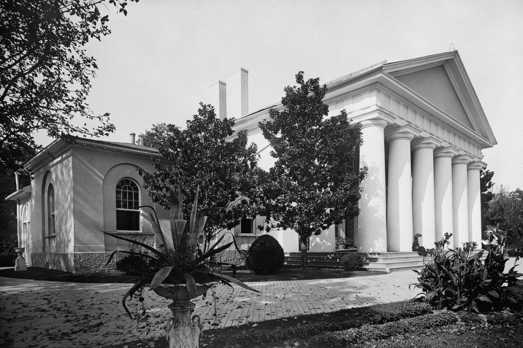
The Arlington House in Arlington National Cemetery, around 1900. Image courtesy of the Library of Congress, Detroit Publishing Company Collection.
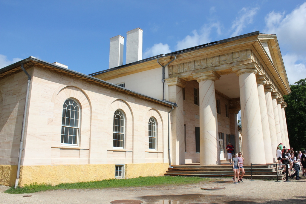
The house in 2018:

This house was built over a period of 15 years between 1803 and 1818, and it was originally the home of George Washington Parke Custis. Born in 1781, Custis was the grandson of Martha Washington, from her first marriage to Daniel Parke Custis. His father, John Parke “Jacky” Custis, had died when George Washington Parke Custis was only a few months old, and George and Martha subsequently raised him as their adopted son. George Washington died in 1799, and Martha in 1802, leaving Custis a significant inheritance. Also in 1802, Custis turned 21, thus inheriting a fortune in money and land from his late father.

Among his father’s land holdings was an 1,100-acre estate on the Potomac River, overlooking the newly-established national capital of Washington. He named the property Arlington, and soon began construction on a mansion, which would become known as Arlington House. For the design, he hired George Hadfield, a noted architect who was responsible for several important buildings in Washington. The exterior of the house featured a very early example of Greek Revival architecture, with its most distinctive feature being the eight large columns here on the front portico. Although it appears to be built of sandstone and marble, the exterior is actually stucco-covered brick, which was intended to give it the appearance of stone.

The War of 1812 delayed construction of the house, but it was completed in 1818. Custis and his wife, Mary Lee Fitzhugh Custis, would go on to live here for the rest of their lives, until her death in 1853 and his in 1857. They had four children, although only one, Mary Anna Randolph Curtis, lived to adulthood. In 1831, at the age of 23, she married 24-year-old army officer Robert E. Lee, in a ceremony that was held here at Arlington House. It would be their home for the next 30 years, during which time Lee steadily rose in rank from a lieutenant to a colonel in the United States Army. He served in the Mexican-American War, and more than a decade later he led the group of soldiers that suppressed John Brown’s raid on the federal arsenal at Harper’s Ferry.

Lee’s wife Mary inherited Arlington House after her father’s death in 1857, but the family did not get to enjoy the property for much longer. On April 16, 1861, four days after the attack on Fort Sumter, Abraham Lincoln offered Lee command of the main Union army. However, Virginia declared its secession the following day, and Lee declined the offer. Instead, he resigned his commission in the the United States Army and joined the Confederate States Army, where he would command the Army of Northern Virginia for most of the war.

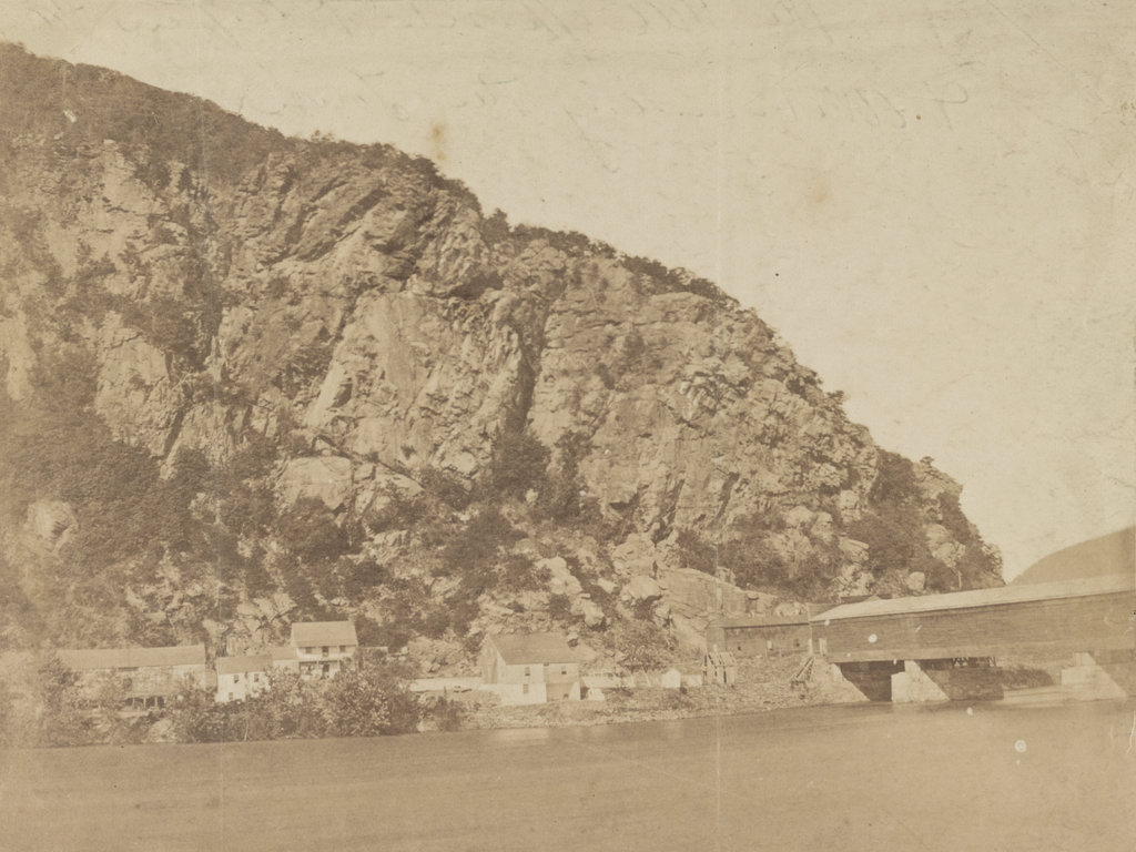
In the meantime, Arlington House quickly became a target for Union forces who were defending Washington. Because of its prominent location overlooking the city, it was imperative that it not fall into Confederate hands. The house was seized on May 24, 1861, and it subsequently became the headquarters of the Army of the Potomac. Despite this occupation, though, the Lee family formally continued to own the house until 1864, when it was taken by the federal government for nonpayment of taxes.

Later in 1864, with the Union needing more space to bury soldiers killed in the war, the property became Arlington National Cemetery. Part of the intention behind this move was to forever deprive Lee of the use of the estate, and to that end many of the early burials were right near the house. The first interment occurred on May 13, and thousands more would follow in the remaining 11 months of the war. These included the remains of 2,111 unidentified Union and Confederate soldiers, whose remains were collected from various battlefields. They were buried in a vault behind and to the left of the house, and the spot is marked by the Civil War Unknowns Monument.

Following the war, neither Robert E. Lee nor Mary Lee ever attempted to reclaim the title of the estate, although their oldest son, George Washington Custis Lee, successfully sued for its return. However, not interested in living in the middle of a cemetery, he then sold the property back to the federal government in 1883 for $150,000. In the ensuing years, though, the government directed most of its attention to the cemetery itself, with little concern for the mansion. By the time the first photo was taken around 1900, the house was largely unused, and the immediate grounds had been heavily altered from their prewar appearance.

The mansion was finally restored in the late 1920s, although the original focus was on the Custis family, as opposed to the Lees. However, in 1955 the house was renamed the Custis-Lee Mansion, and then in 1972 it became Arlington House, The Robert E. Lee Memorial, thus placing a greater emphasis on Lee’s connection to the house. It has remained in use as a museum since then, although it was closed for renovations in early 2018, a few months before the first photo was taken. As part of this project, the house will be restored to its 1860 appearance, and the slave quarters and surrounding grounds will also be restored. The work will cost an estimated $12.35 million, and it is scheduled to be completed in January 2020.

Inauguration of Abraham Lincoln, Washington, DC

The east front of the United States Capitol, during the inauguration of Abraham Lincoln on March 4, 1861. Image courtesy of the Library of Congress.

The Capitol in 2018:

The first photo was taken around the same time as the one in a previous post, but this one shows the view from further back, with the entire unfinished Capitol dome in view, along with the crowd that had assembled for Lincoln’s first inauguration. It was the culmination of the highly-contentious 1860 presidential election, which saw the splintering of the Democratic Party into regional factions. Lincoln won the four-way race amid threats of secession from the south, and by the time he was inaugurated on March 4, 1861, seven southern states had followed through on their plans.

Because of this, there was a great deal of uncertainty on the day that the first photograph was taken. The start of the Civil War was just over a month away, and there were still plenty of questions about whether the South would be allowed to peacefully secede, or if the newly-inaugurated president would send an army to stop them. Appropriately enough, the backdrop to this event is the unfinished dome of the Capitol. Begun six years earlier, this new dome was still very much a work in progress during Lincoln’s inauguration, and it seemingly represented the as yet unfinished work of uniting the northern and southern regions of the nation.

The Capitol building itself is actually significantly older than this dome, though. Construction began in 1793, and the Senate and House wings were completed in 1800 and 1811, respectively. However, the building was burned in 1814, during the War of 1812, and its reconstruction was not ultimately finished until 1826. At the time, the building was topped by a low dome, which is visible in the first photo of another previous post. As the country grew, though, so did the Capitol building, and two new wings were added in the 1850s. As a result, the old dome looked out of proportion to the old building, so construction began on the current one in 1855.

During the early 19th century, the Capitol became the primary site of presidential inaugurations. At first, these ceremonies were held indoors, in either the Senate of House chambers, but in 1829 Andrew Jackson became the first president to be inaugurated here on the East Portico. This started a tradition that, with few exceptions, continued into the late 20th century. Jimmy Carter’s 1977 inauguration was the last to be held here on the East Portico, and since 1981 the ceremony has – with the exception of Ronald Reagan’s 1985 inauguration in the Rotunda – been held on the West Portico, on the side of the building facing the National Mall and the Washington Monument.

Four years to the day after the first photo was taken, Lincoln’s second inauguration would also be held here on the East Portico. By then, the exterior of the dome had been completed, and Lincoln’s goal of reuniting the nation had likewise been largely accomplished, with the end of the Civil War only weeks away. However, less than a week after Lee’s surrender, and only 42 days into his second term, Lincoln was assassinated by John Wilkes Booth, who had actually attended the second inauguration here, and had later claimed that he could have killed Lincoln during the event if he had wanted to.

Today, more than 150 years after the first photo was taken, the East Portico does not appear to have changed much. However, it actually underwent a major expansion starting in 1958, when a new portico was built 32 feet 6 inches in front of the old one. Aside from being built of marble, as opposed to the sandstone of the original walls, this new portico was essentially a duplicate. The old walls remain intact inside the building, although the original columns were removed and now stand in the National Arboretum. The 1958 renovations also involved the removal of two statues that once flanked the east steps. On the left, mostly hidden from view in the first photo, was Luigi Persico’s Discovery of America, and on the right was Horatio Greenough’s The Rescue. Both of these statues featured particularly unflattering depictions of Native Americans, and neither have been put on public display since then.

The other significant addition to this part of the Capitol occurred in the early 2000s, when the Capitol Visitor Center was constructed here. Consisting of 580,000 square feet of floor space on three floors, this massive expansion is almost entirely hidden from view in this scene, as it is located directly under the plaza in front of the East Portico. From this angle, the only visible signs of this underground complex are several skylights, including one on the far left side of the scene.

John Brown’s Fort, Harpers Ferry, West Virginia

The fire engine house at the Harpers Ferry Armory, more commonly referred to as “John Brown’s Fort,” as seen around 1860. Image courtesy of the Library of Congress, Civil War Collection.

732_1860c loc

The same view in May 1939. Image courtesy of the Library of Congress, FSA/OWI Collection.

732_1939-05 loc

The scene in 2015:

732_2015 loc
This small, seemingly nondescript building was built in 1848 at the entrance to the Harpers Ferry Armory, and was used as a guard house and fire engine house.  Normally, such a building would not be the subject of an 1860s stereocard, but it gained widespread fame just a few years earlier, due to its role in John Brown’s raid on the armory.

On October 16, 1859, northern abolitionist John Brown led a group of 22 men who attempted to take the armory and start a slave rebellion. They succeeded in taking the armory, and took a number of Harpers Ferry citizens hostage, but the plan quickly unraveled and they ended up barricading themselves in this building, surrounded by local militiamen and other armed townspeople.  Eventually, Colonel Robert E. Lee, still fighting in the US Army at the time, led a detachment of Marines, who succeeded in taking the building and capturing John Brown and most of his men.

To many northern abolitionists, John Brown was a hero, but to southern slaveowners he was a dangerous radical and a criminal. He was executed on December 2 in nearby Charles Town, but the failed raid helped to set the Civil War in motion a little over a year later.  The first photo was probably taken within three years of the raid, and in it the building still bears some of the scars from the fight.

Unlike most of the armory buildings, this one actually survived the war, and over time it became a tourist attraction and a symbol of the abolitionist movement. However, many residents feared that it would become a major draw for African-Americans to visit the town, so they were looking for ways to get rid of it.  Finally, in 1891 the owners decided to dismantle the fort and reassemble it at the World’s Columbian Exposition in Chicago.  It was a colossal failure at the exposition, though; the move cost $60,000, and just 11 people paid the 50 cent admission fee to view the fort.

The fort underwent further dismantlings and reconstructions, before eventually moving to its present-day site about 150 feet to the right of here.  However, it doesn’t have much real historic value, because of the number of times it has been reconstructed and the amount of original materials that has been lost over time.

After the fort was moved from here, the Baltimore & Ohio Railroad built new railroad embankments through the site of the fort, so today it is at a substantially higher elevation than it was in the first photo.  The monument, seen in the last two photos, was added by the railroad and marks the original location.

Harpers Ferry, West Virginia (2)

The town of Harpers Ferry, photographed around 1862. Image courtesy of the Library of Congress, Civil War Collection.

731_1860c loc

The view in 2015:

731_2015 loc
These two views of Harpers Ferry are remarkably similar, considering how much damage the small town sustained during the Civil War.  The Library of Congress estimates that this photo was taken around 1860, which seems a little too early.  This photo is half of a stereocard from a series called “War Views,” and since the war didn’t start until 1861, it seems unlikely that it was taken before then.  Instead, it was probably taken around 1862; the tents in the foreground were part of a “contraband camp” that the Union army established on the grounds of the former armory in March 1862 to house escaped slaves from the Confederacy.

A number of notable buildings are visible here, with the most prominent being the Armory fire engine house, better known as “John Brown’s Fort,” seen in the center of the photo and explained in more detail in this post.  To the left of the “fort” is the Gerard Bond Wager Building, a three and a half story brick building that was completed in 1838.  Prior to the Civil War it was used as a grocery and dry goods store, and it is still standing today and is operated by the National Park Service as a museum.

Beyond the Gerard Bond Wager Building is St. Peter’s Roman Catholic Church, which was built in 1833 and is still standing today, although with some extensive alterations.  It survived the Civil War, but it was renovated in 1896 to bring its exterior in line with the then-popular Neo-Gothic architectural style.  The original brick walls were replaced with granite, the steeple was removed, and a new asymmetrical facade was built with a taller steeple on the left side.

Another church in the original scene was St. John’s Episcopal Church, seen on the top of the hill to the right.  It was built in 1852 and sustained damage during the war, eventually being repaired in 1882.  However, it was subsequently abandoned in 1896, and today the picturesque ruins are still there, although they are hidden from view by the trees in the 2015 photo.

The last of the prominent historic buildings in these two photos are the four in a row next to each other, seen just below St. John’s Episcopal Church.  All four are still standing today, and the left-most of these is the Harper House, which is the oldest surviving building in the lower town.  It was completed in 1782 by Robert Harper, the town founder who not coincidentally operated a ferry here.  He died the same year it was completed, and it was later used as a tavern, a private residence, and by the start of the Civil War as a tenement house, accommodating up to four families.  To the right of the Harper House is Marmion Hall, which was completed in 1833, and the last two buildings to the right were built in the 1840s as the Marmion Tenant Houses.  These last two were, prior to the war, rented out to armory workers, who were just a short downhill walk away from their jobs.

Today, railroad tracks cover much of the former armory site, and nearly all traces of the historic site are long gone.  However, the town that grew up here because of the armory is, for the most part, preserved in its pre-1860s appearance.  Much of the lower town is now part of the Harpers Ferry National Historical Park, and is run by the National Park Service.

Armory at Harpers Ferry, West Virginia

The ruins of the Harpers Ferry Armory, photographed in October 1862. Image courtesy of the Library of Congress, Civil War Collection.

730_1862-10 loc

The scene in 2015:

730_2015 loc
Prior to the Civil War, Harpers Ferry was the location of one of the country’s two federal armories, with the other being in Springfield, Massachusetts.  Both sites were chosen by George Washington, and they had similar advantages.  Harpers Ferry and Springfield are both located on major rivers at the intersection of major transportation routes, but they are also located above the head of navigation on their respective rivers, preventing a naval attack from a foreign enemy.

In the first half of the 19th century, these two armories developed new ways to manufacture firearms, using machinery that mass-produced identical, interchangeable parts and that could be operated by unskilled workers.  By the start of the Civil War, there were over 15,000 guns stored here, which helped entice John Brown to lead a raiding party in 1859.  His goal was to start a slave rebellion by taking the arsenal and distributing the weapons to area slaves, and although the plan failed, it helped to spark the Civil War only a year and a half later.

By the time the first photo had been taken in October 1862, Harpers Ferry had already changed hands a number of times in the Civil War, and armies on both sides had steadily destroyed the buildings in order to prevent the other side from making use of them.  The ruins seen here are from the same building that can be seen on the right hand side of the 1861 photo in this post.

Around the time that the first photo was taken, the ruins had several notable visitors, including Abraham Lincoln, who toured the armory site in October, perhaps on the same day that the photo was taken.  Author Nathaniel Hawthorne also visited Harpers Ferry earlier in 1862, and wrote the following description in his essay “Chiefly About War Matters”:

Immediately on the shore of the Potomac, and extending back towards the town, lay the dismal ruins of the United States arsenal and armory, consisting of piles of broken bricks and a waste of shapeless demolition, amid which we saw gun-barrels in heaps of hundreds together. They were the relics of conflagration, bent with the heat of fire, and rusted with the wintry rain to which they had since been exposed. The brightest sunshine could not have made the scene cheerful, nor have taken away from the gloom from the dilapidated town; for, besides the natural shabbiness, and decayed, unthrifty look of a Virginian village, it has an inexpressible forlorness resulting from the devastations of war and its occupation by both armies alternately.

The town became part of West Virginia in 1863, and things were relatively stable here until the end of the war.  However, at that point the damage had been done.  The pre-war economy of Harpers Ferry had relied almost exclusively on the armory, but it was never rebuilt following the war.  The land was sold, and the Baltimore & Ohio built railroad tracks through part of the land, including the present-day railroad station, which was completed in 1889. Today, this area is part of the Harpers Ferry National Historical Park, and although there are no buildings still standing here from the armory, the interpretive signs help to give visitors an idea of what was once here.

Maryland Heights from Harpers Ferry, West Virginia

Looking across the Potomac River toward Maryland from Harpers Ferry, around 1859. Image courtesy of the Library of Congress, Civil War Collection.

729_1859c loc

The scene in 2015:

729_2015 loc
Assuming the estimated date is correct, the first photo was probably taken within a few months before or after John Brown’s raid on the Harpers Ferry Armory.  It shows the view from the Armory looking across the Potomac River toward Maryland Heights, with the Baltimore & Ohio Railroad bridge to the right.  The Chesapeake & Ohio Canal also ran through this scene; the buildings across the river were built on either side of Lock 33.

Within a few years, much of this scene would change.  Harpers Ferry changed hands many times during the war, and during one of their retreats the Confederate forces burned the bridge, as seen in the 1861 photo in the previous post, which was taken from the opposite side of the river.  The bridge has since been replaced several times, and the current one can be seen on the far right, a little upstream of the original one.

The Chesapeake & Ohio Canal survived the war, and despite increased competition from railroads it remained in operation until 1924.  Today, the stone remains of Lock 33 are still standing, hidden from this view by the railroad bridge and the trees along the river.  All of the buildings have long since disappeared, though, except for one: the two story stone house right up against the cliff on the left side of the photo.  It was built in the winter of 1840-1841, and survived John Brown’s raid, the Civil War, and a number of floods before being gutted by a fire in the 1960s. The stone walls are still standing, though, and it is now part of the Harpers Ferry National Historical Park.

One historical curiosity in the second photo is the advertisement painted on the rocks near the center of the photo.  It reads “Mennen’s Borated Talcum Toilet Powder,” and it was painted in 1906 for railroad passengers as they traveled through here.  Although not as distinct as it once was, the controversial advertisement is still there, despite efforts in the 1960s to remove it using paint remover and carbon black.