Mount Jefferson from Mount Monroe, New Hampshire

Mount Jefferson and the northern Presidential Range from near the summit of Mount Monroe, around 1900. Image courtesy of the Library of Congress, Detroit Publishing Company Collection.

The scene in 2020:

The first photo here was taken from the same spot, and perhaps even on the same day, as the one in the previous post. However, while that photo shows the summit of Mount Washington from Mount Monroe, this view looks a little further to the west, showing the western side of Mount Washington with Mount Jefferson further in the distance. As was the case with the previous post, I took the 2020 photo without having first seen the 1900 one. I took the photos during a hike along the southern Presidential Range from Crawford Notch to Mount Monroe, and later discovered that several of the photos lined up perfectly with ones that were taken around 1900 by the Detroit Publishing Company. In this particular view, perhaps the most remarkable similarity is that both photos show a Mount Washington Cog Railway train in the exact same location, right in the center of the photo.

The highest mountain visible in this scene is Mount Jefferson, which is a little over three miles away from here. At 5,712 feet, it is the third-highest peak in the northeastern United States, after the nearby Mount Washington and Mount Adams. Along with Mount Madison and Mount Monroe, these comprise the five highest peaks in the region, and they are named in honor of the first five presidents, with the elevation rank corresponding to the order in which they served as president. However, Madison and Monroe are very close in elevation, and subsequent surveys discovered that Monroe is actually slightly higher, despite being named for the fifth president.

Aside from Mount Jefferson, the most visible landscape feature here is Ammonoosuc Ravine, a large glacial cirque in the foreground that forms the western slope of Mount Washington. Further in the distance is Burt Ravine, a somewhat smaller cirque to the northwest of Mount Washington. In between these two ravines is a ridgeline that runs diagonally across this scene. The steep slopes of this ridge, combined with the heavy precipitation here, makes it prone to landslides, and both photos show the scars of large slides here on the southern side of the ridge.

Both photos also show the Mount Washington Cog Railway, which runs along this ridge between Ammonoosuc and Burt Ravines. Completed in 1869, this three-mile railroad was a major engineering feat, with trains rising about 3,500 feet in elevation from the base station to the summit. This was far too steep for conventional trains, so the railway’s founder, Sylvester Marsh, developed a rack-and-pinion system with a gear on the locomotive that engaged a rack in the center of the track. This allowed the gear to pull the train up the mountain, and then safely lower it in a controlled descent on the return trip.

The Mount Washington Cog Railway was the first of its kind in the world, and it today it is the world’s second-steepest railroad. The single steepest part of the route is a trestle known as Jacob’s ladder, with a maximum grade of more than 37%. This trestle is visible in the center of both photos, and coincidentally both photos show a train at the same spot at the base of the trestle. As was the case more than a century ago, the trains still climb and descend with the locomotive always on the downhill side of the train and a single passenger coach facing uphill. The only difference is the type of locomotive; for most of the railroad’s history it operated steam locomotives, but it now primarily uses biodiesel locomotives, which are more environmentally friendly and less expensive to run.

Overall, the type of locomotive on the trestle is essentially the only difference between these two photos. Although the summit of Mount Washington has been heavily developed with over the years with many buildings and other structures, the rest of the Presidential Range has remained largely unchanged, with few signs of human activity aside from hiking trails. Most of the range, along with much of the surrounding land, is now protected as part of the White Mountain National Forest, which was established in 1918 and has grown to over 750,000 acres of land in New Hampshire and Maine.

Mount Washington from Mount Monroe, New Hampshire

The summit of Mount Washington, seen looking north from Mount Monroe in the Presidential Range of the White Mountains, around 1900. Image courtesy of the Library of Congress, Detroit Publishing Company Collection.

The view in 2020:

Rising 6,288 feet above sea level, Mount Washington is the highest peak in the northeastern United States. It stands at the center of the Presidential Range, a north-south oriented mountain range that forms a massive ridgeline of bare rocks and alpine vegetation. The range is infamous for its harsh and unpredictable weather, particularly at the summit of Mount Washington, which for many years held the world record for fastest surface wind speed ever recorded, at 231 miles per hour. Hypothermia is a year-round threat to hikers, and although there is no permanent ice cap, pockets of snow can linger well into the summer, as shown in the 2020 photo, which was taken on June 18.

Aside from Mount Washington, most of the other peaks in the range are also named for presidents. The five highest peaks are named after the first five presidents, in order of elevation, so that Mount Adams is the second-highest and Jefferson the third-highest. However, Mount Monroe, where these photos were taken from, is actually the fourth-highest, but it was named for the fifth president because of a surveying error. Monroe is the southernmost of these five major peaks; to the south are several lower peaks in the Presidential Range, including Mount Eisenhower and Mount Pierce.

Mount Washington’s high elevation and inhospitable climate have long attracted visitors to the summit. The first recorded ascent occurred in 1642, when Darby Field climbed the mountain accompanied by two Native American guides. Governor John Winthrop recorded the event in his diary, referring to the mountain as “the white hill,” since the mountain’s eventual namesake would not be born for another 90 years. Field’s exact route is uncertain, but he evidently approached it from the south, as Winthrop mentions two ponds along the way, which were likely the Lakes of the Clouds shown here in this scene. Aside from helping determine Field’s route, the mention of the lakes also helps to verify his ascent, since he would not have known about them unless he actually climbed at least this far.

The mountain was only occasionally climbed during the rest of the 17th and 18th centuries, but this began to change in the early 19th century. In 1819, local residents Abel and Ethan Allen Crawford cut an 8.5-mile path from Crawford Notch to the summit of Mount Washington, following the ridgeline of the southern Presidential Range. The trail passed through this scene just to the East of the summit of Mount Monroe, and most of it is still in use today as part of the Appalachian Trail, making it the oldest continuously-maintained hiking trail in the country. Ethan Allen Crawford built a cabin, and later a hotel, at the base of the trail, and he also acted as a guide for hiking groups setting out from Crawford Notch. The Crawford family later improved the trail for use as a bridle path, and by the 1840s visitors could ride to the top of the mountain on horseback.

The first building at the summit was a small hotel that opened in 1852. It was joined a year later by the rival Tip Top House, which still stands atop the mountain today. At the time, the only ways to get to the top were by foot or by horseback, but this would soon change. The Mount Washington Carriage Road opened in 1861, bringing visitors up the east side of the mountain, and the Mount Washington Cog Railway followed eight years later on the western slopes of the mountain. These two routes helped to spur more development, and by the time the first photo was taken around 1900 the summit was crowded with buildings, including the Tip Top House, a weather observatory, and the massive Summit House hotel, which could accommodate 150 guests. The summit even had its own daily newspaper, Among the Clouds, which was published during the summer months from 1877 to 1917.

By the late 19th century it was easier than ever to reach the summit, but many visitors chose to test their abilities by hiking up the mountain. However, because of the mountain’s notorious and often unpredictable weather, this sometimes led to tragic consequences for unprepared or unlucky hikers. The first known fatality in the Presidential Range was Frederick Strickland, who began his hike on October 19, 1849, when the mountain was already covered in deep snow. He climbed via the Crawford Notch, and he would have passed through this scene on his way up the mountain. Strickland made it to the top, becoming the first known hiker to do so in winter conditions, but he ultimately succumbed to hypothermia while descending the western side of the mountain. His body was discovered well below the tree line, near where the present-day Jewell Trail crosses Clay Brook.

One of the most famous tragedies on the mountain occurred on June 30, 1900, when William Buckingham Curtis and Alan Ormsbee both died of hypothermia while ascending the mountain. Both men were experienced outdoorsmen, and Curtis was renowned as an athlete and promoter of amateur athletics. As with Frederick Strickland a half century earlier, they hiked up the Crawford Path from Crawford Notch. Their goal was to attend the Appalachian Mountain Club meeting at the summit, but they faced harsh conditions along the way, including dense fog, sleet, and high winds. They climbed to the summit of Pleasant Dome (now Mount Eisenhower), and they were last seen alive soon after by a descending group that warned them of the deteriorating conditions ahead.

The first photo was probably taken within a year or two of Curtis’s and Ormsbee’s deaths, and it shows the section of the mountain where their journey came to an end. It is unclear as to whether they took the Crawford Path to the east of Mount Monroe, or if they took  the loop trail over the summit, but just to the north of Monroe they took shelter in a dense stand of stunted spruce trees. For unknown reasons, they subsequently left this shelter, and Curtis’s body was discovered a short distance beyond the trees, somewhere near the foreground on the far right side of these two photos. Ormsbee managed to continue up the mountain, but he ultimately died just a few hundred feet short of the summit.

In the aftermath of this tragedy, the Appalachian Mountain Club built a small shelter here in the area between Mount Monroe and Mount Washington, near the spot where Curtis died. It was completed in 1901, and was large enough for about six to eight people, yet uncomfortable enough to discourage use for anything other than an emergency situation. However, hikers nonetheless used the shelter for regular camping, and in 1915 it was replaced by the Lakes of the Clouds Hut, which was built a little lower on the slope on the far left side of the scene. Far more than just serving as an emergency shelter, this hit was staffed by the AMC, and provided overnight accommodations along with meals for hikers.

Today, around 120 years after the first photo was taken, Mount Washington remains a popular destination, accessible either by train, by car, or by foot. The Lakes of the Clouds Hut has been expanded several times over the years, and it now has bunk space for 90 hikers. The hut is located at the convergence of several major trails, including the Crawford Path, which still follows essentially the same route that the Crawford family laid out more than two centuries ago. The only significant change to the path is here between Mount Monroe and Mount Washington, where it was rerouted to access the hut, and to eliminate unnecessary switchbacks.

Overall, this scene has changed very little since the first photo was taken, aside from the construction of the hut. The surrounding land is now protected as part of the 750,000-acre White Mountain National Forest, which was established in 1918. The Presidential Range is a particularly important part of this national forest, as it features a number of rare alpine plants, including the Robbins’ cinquefoil, an extremely rare flower that can only be found here on the slopes of Mount Monroe. Because of the fragile nature of many of these plant species, combined with the thousands of people who climb Mount Washington each year, one of the present-day challenges here is balancing conservation with recreation in order to ensure that this view continues to remain unchanged for the next 120 years and beyond.

The Oxbow from Mount Holyoke, Hadley Mass

The view looking southwest from the Mount Holyoke Summit House around 1900. Image courtesy of the Library of Congress, Detroit Publishing Company Collection.

563_1900c loc

The scene in 2015:

563_2015
This scene from the summit of Mount Holyoke was made famous in 1836 when artist Thomas Cole painted “View from Mount Holyoke, Northampton, Massachusetts, after a Thunderstorm,” a work also known as “The Oxbow” because of the prominent meander in the river.  Cole’s depiction of the scene is below:

Cole_Thomas_The_Oxbow_(The_Connecticut_River_near_Northampton_1836)
The top of Mount Holyoke has long been a sightseeing destination, starting even before Cole’s 1830s visit.  In 1821, a small cabin was built at the summit, which was replaced in 1851 by a much larger hotel, which still stands today.  The 2015 photo, and presumably the 1900 photo, were both taken from the porch that surrounds the building, and they reveal some of the changes that have occurred in the landscape over the past 115 years.  However, probably the most obvious change here occurred long before the first photo was taken, and not long after Thomas Cole painted his famous work.  In 1840, a flood broke through the narrow neck, giving the Connecticut River a more direct route downstream and turning the former riverbed into a lake.  It also made travel easier; traffic no longer had to follow the meandering river, and the 1900 scene shows the railroad tracks that had been built across what was once the river.  Today, Route 5 parallels the railroad tracks, and Interstate 91 crosses the Oxbow just a little further to the west.

When the 1900 photo was taken, the Oxbow played an important role in river commerce as a holding place for logs that were floated downstream.  Each spring in the late 1800s and early 1900s, logs from upstream in Vermont and New Hampshire would be floated down the river to the paper mills in Holyoke.  Since it is just a short distance upstream of Holyoke, the Oxbow made for a convenient holding place away from the main channel of the river.  The last such log drive occurred in 1915, and since then it has been used primarily for pleasure boats, with the Oxbow Marina located on the inside of the curve.  There are no dams between Holyoke to the south and Turners Falls to the north, so this section is one of the busiest on the Connecticut River for recreational boating.

Mt. Washington Cog Railway

The Mt. Washington Cog Railway, near the summit, probably in the early 1870s. Photo courtesy of New York Public Library.

446_1860sc-2Bnypl

The scene in 2013:

446_2013

The first photo was probably taken within a few years of the opening of the Mt. Washington Cog Railway.  By the mid 19th century, the White Mountains had become a popular summer destination, and Mount Washington in particular became a favorite destination.  The only problem was getting to the top; this was first solved by the Mount Washington Carriage Road (today the Auto Road), but even before the road opened, another man had an even more ambitious idea – to build a railroad to the top.

Railroads were still in their infancy in America in 1852, and many major cities still did not have rail connections, but Sylvester Marsh had a plan to build a cog railway to the top, something that had never been done up the side of a mountain before.  The New Hampshire legislature gave him a charter in 1858, with one legislator reportedly remarking that they should give him a charter to make a railway to the moon, indicating how impossible it seemed to build a railroad to the top of the tallest peak in the Northeast.

The railroad was completed to the summit in July 1869, only a couple months after the completion of the Transcontinental Railroad.  It is about 3 miles long, with an average grade of about 25%, and it set the stage for future mountain-climbing railroads such as the one up Pikes Peak.  The locomotives in the first photo indicate that it is an early photo of the railroad; they appear to be the George Stephenson and the Hercules, which entered service in 1869 and were replaced in 1878 and 1874, respectively.

The present-day scene here is remarkably similar; the trains are still operating (most of the locomotives are modern biodiesel ones, but several date back to the 1870s), and there seems to be as many people riding in the 2013 photo as there were nearly 150 years earlier, although clothing styles have changed a bit.  It’s not visible from here, but the road to the top is also still there, although it is no longer the Carriage Road but the Auto Road.  There are a lot more buildings at the top than there were in the 1870s, although the Tip Top House is still there; it is older than either the Auto Road or the railroad.

Mount Tom Summit House, Holyoke, Mass. (2)

The view of the Mount Tom Summit House between 1905 and 1915. Image courtesy of the Library of Congress, Detroit Publishing Company Collection.

160_1905-1915-loc

The view in 2014:

160_2014

These photos were taken from near the location of the upper station of the trolley line; from here, visitors would walk up to the Summit House. Today, the Metacomet & Monadnock Trail traverses the summit and goes past the location where the photos were taken, on its way from the Connecticut state line to the summit of Mt. Monadnock in southern New Hampshire.

Mount Tom Summit House, Holyoke, Mass.

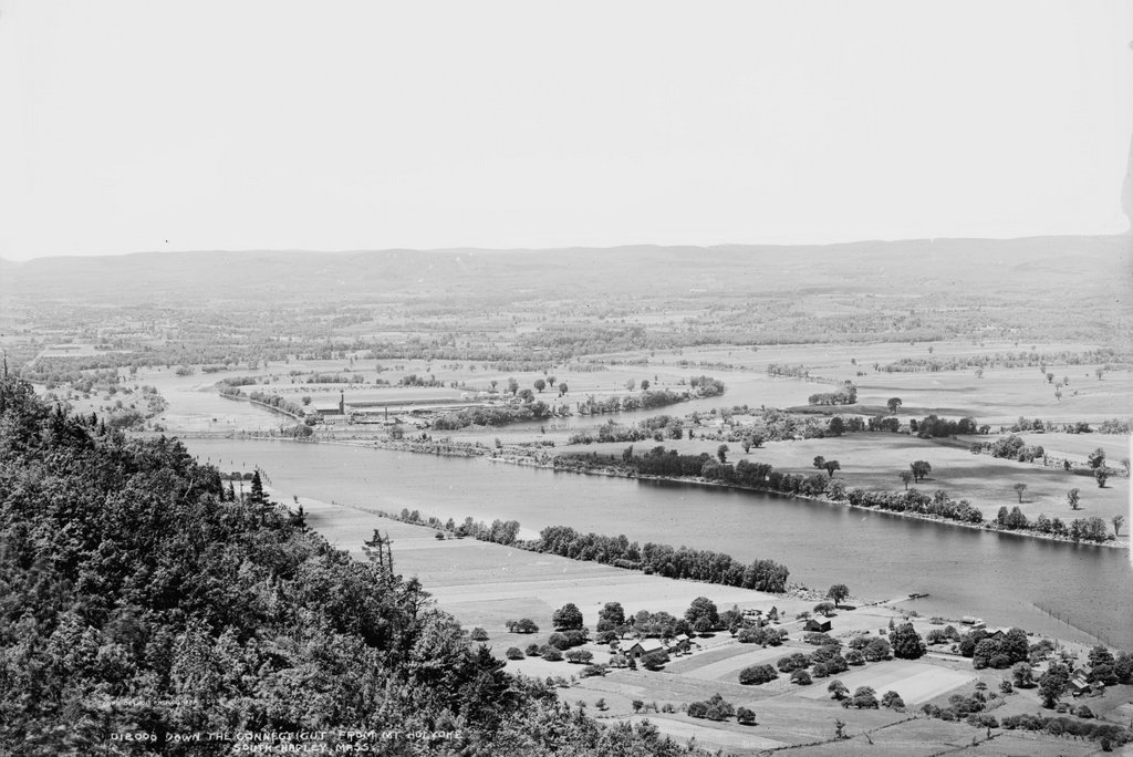
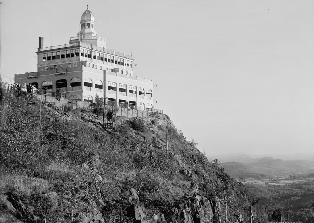
The view of the Mount Tom Summit House around 1901-1905. Image courtesy of the Library of Congress, Detroit Publishing Company Collection.

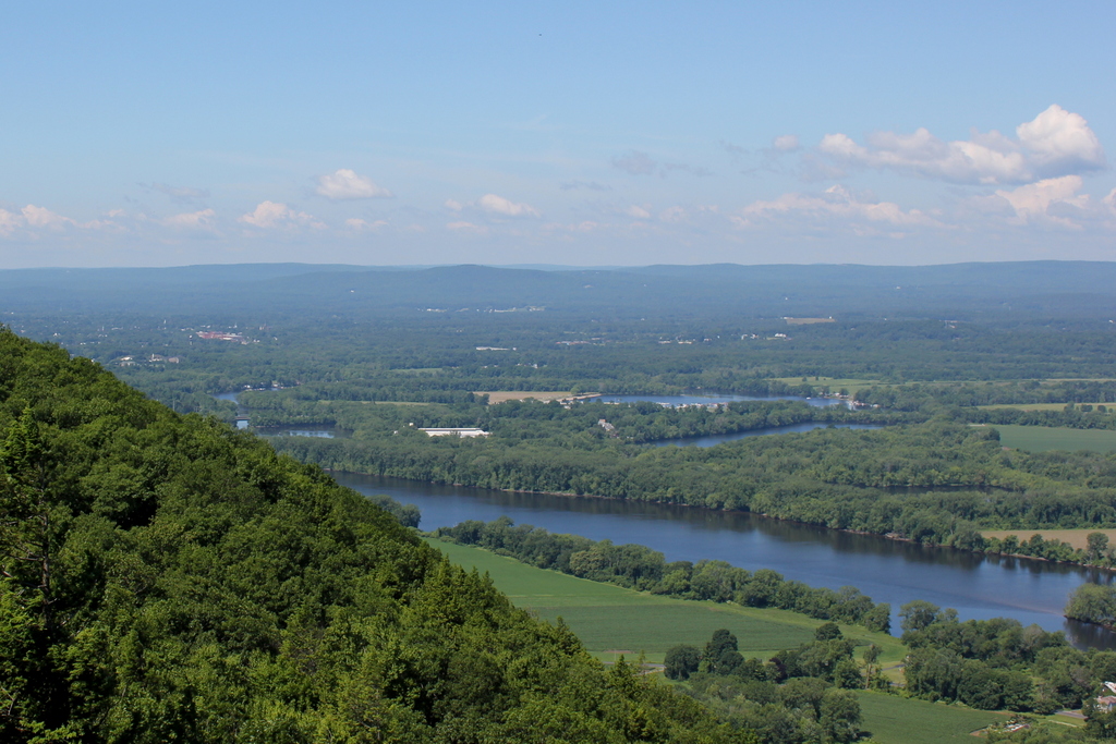
The same view in 2019:

Rising more than 1,200 feet above sea level, Mount Tom is the highest point on the Metacomet Ridge, a narrow traprock mountain range that extends through Connecticut and Massachusetts from Long Island Sound to just south of the Vermont border. Although modest in elevation compared to the much higher mountains to the west of here in the Berkshires, Mount Tom and the other peaks on the Metacomet Ridge stand out because they are situated in the middle of the Connecticut River valley. As a result, Mount Tom stands nearly a thousand feet higher than the surrounding landscape, making it the most topographically-prominent mountain in the state outside of the Berkshires.

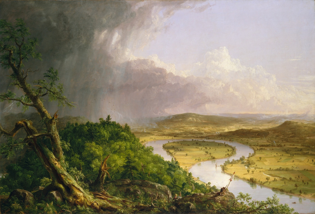
Because of this prominence, the major peaks of the Metacomet Ridge, particularly Mount Tom and nearby Mount Holyoke, became popular destinations starting in the 19th century. This was the era of grand mountaintop resorts, and one of the first in the country was located atop Mount Holyoke, where the view inspired Thomas Cole to paint The Oxbow, one of the most celebrated landscape paintings in the history of American art. The Summit House on Mount Holyoke was soon joined by the rival Eyrie House, which opened in 1861 on Mount Nonotuck, at the northern end of the Mount Tom Range. Together, these two hotels stood watch on opposite sides of the Connecticut River throughout the 19th century.

However, the main peak of Mount Tom, which is located here at the extreme southern end of the mountain, remained undeveloped for many years. Then, in the 1890s, William S. Loomis of the Holyoke Street Railway purchased a large tract of land on the mountain, including the summit, and began developing it into a trolley park for his company. Such parks were common during this period, as the trolley companies benefited not only from admission prices, but also from the increased ridership on weekends, when trolley lines were normally less busy.

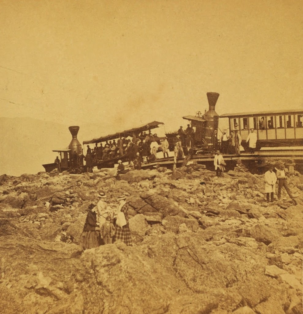
At the base of the mountain, the Holyoke Street Railway built Mountain Park, which featured attractions such as a dance hall, a restaurant, a small roller coaster, and a carousel. These were fairly typical for trolley parks of the era, but a far more ambitious plan involved constructing a funicular railway from the park to the summit. It was known as the Mount Tom Railroad, and it was just under a mile in length, with a total elevation gain of 700 feet. The line featured two trolley cars and one track, with a turnout halfway up the mountain to allow the two cars to pass each other. Both cars were connected via a cable, so that as one car descended, the other ascended. This arrangement significantly reduced the amount of power needed to climb the mountain, as the weight of the descending car helped to pull the other one up.

The railway was completed in 1897, and that same year the first Summit House opened here at the top. It was not a hotel, unlike the older buildings on Mount Holyoke and Mount Nonotuck, but it offered a variety of other amenities for visitors. The first floor featured a restaurant, dining room, and parlors, and the second floor included a stage. On the top of the building was a cupola, with an observatory that was equipped with telescopes. Use of the Summit House was included in the railway fare, which cost 25 cents for a round trip when it first opened.

The Summit House soon proved to be popular, and probably its most distinguished visitor was President William McKinley, who traveled up the mountain with his wife Ida in 1899 and purportedly declared the view to be “the most beautiful mountain out look in the whole world.” The McKinleys’ visit, which included lunch at the Summit House, was well-publicized, and it was even captured on film, in a 30-second clip that still survives today. In the footage, the president and first lady are shown leaving the Summit House and walking along the promenade on the west side of the building, not far from where the first photo in this post was later taken.

Unfortunately, the first Summit House on Mount Tom did not last long. Just three years after its completion, it was destroyed by a fire on October 8, 1900. The cause of the blaze was never determined, although it apparently started in the basement, where the watchman discovered it around 8:45 p.m. Some of the contents were rescued from the burning building, but otherwise it was a total loss. The fire proved to be quite a spectacle for the surrounding area, and it was reportedly visible from at least 20 miles away. The Springfield Republican, reporting on it the following day, dramatically described how “From one end of the valley to the other, north and south, men’s eyes were turned to the beacon of flame in wonder, in pity, and in admiration.” Further in its narrative, the newspaper declared that “The sight of such a titanic bonfire will not soon be forgotten by those who witnessed it.”

Mountaintop buildings were particularly vulnerable to fires. Not only were they generally built of wood, but they were also located far from water sources, making firefighting a challenge. Just six months later, in April 1901, the nearby Eyrie House on Mount Nonotuck suffered the same fate as the first Summit House. In that case, the fire began after the owner, William Street, cremated two horses that had died at the top of the mountain. After the cremation, Street believed that the fire was out, but it reignited during the night, destroying the old hotel and the other buildings at the summit. The Eyrie House was never rebuilt, and its ruins still stand at the top of the mountain.

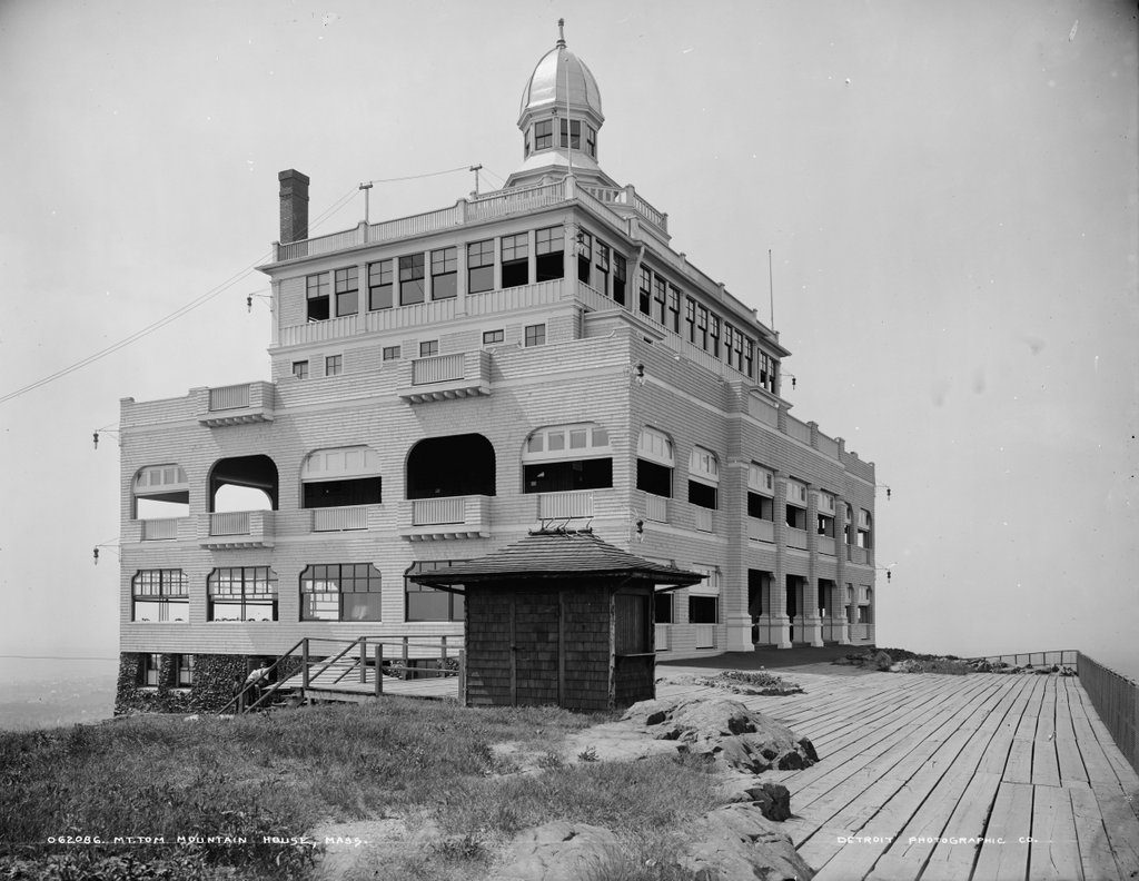
Here at the Summit House, though, the owners moved quickly to construct a new building. The second Summit House, which is shown here in the first photo, was completed in 1901, and it was significantly larger than the original one. The dining room was located on the first floor, with a hall and stage on the second floor. Both of these floors also had 14-foot-wide piazzas that extended around the entire building. The third floor featured another hall, along with storerooms and water tanks, and it was surrounded by an open deck above the piazzas.

The main observatory, with its large plate glass windows, was on the fourth floor, but there were three more levels of observatories that rose above it. The highest level was the cupola, which measured 11 feet in diameter and stood nearly a hundred feet above the ground. It was equipped with telescopes, and it was topped by an octagonal copper dome that was covered in gold leaf. Overall, the Summit House cost about $25,000 to build, and it was designed by local architect James A. Clough, who was responsible for a number of important buildings in Holyoke at the turn of the 20th century.

The first photo was taken within a few years after the new Summit house was completed, and it shows the northwest corner of the building. On the right is the boardwalk that, only a few years earlier, President McKinley had walked on. Just beyond the railing is the steep western cliff of the mountain, and from here visitors could enjoy panoramic views of Easthampton and the surrounding landscape, with the Berkshire mountains further to the west. The east side of the mountain, which is partially seen on the left side of the photo, slopes down more gently, but it still afforded views to the south and east, facing toward the cities of Holyoke and Springfield. In the foreground, in the center of the photo, is a small kiosk. It appears to have been closed at the time, but in other photos of the summit it has a sign advertising for salted peanuts and corn cakes, which could be had for five cents.

With the new Summit House completed, visitors continued to make the trip up the mountain in large numbers. In 1903, the Springfield Republican reported that around 60,000 to 80,000 people came here each year, during the nearly six-month operating season. Up to that point, the single-day record was 3,300 people, which occurred on a Labor Day. Around 1904, one of the visitors to the mountaintop was a young Calvin Coolidge, who came up here with his future wife, Grace Goodhue, early in their courtship. He purchased a porcelain plaque of the mountain here, and this became the first gift that he ever gave to her.

Throughout the first quarter of the 20th century, the Summit House remained a popular attraction. The number of visitors remained fairly constant during this time, with an average of about 75,000 in its later years, and 80,000 in its last full season of operation in 1928. However, like its predecessor, this Summit House was also destroyed in a fire. The night watchman discovered the fire on the observation floor around 6:00 p.m. on the night of May 2, 1929. After alerting the fire department he attempted to extinguish the flames himself, but he was unsuccessful. By the time the firefighters arrived, there was little that could be done to save the building. These efforts were hampered, at least in part, by the fact that the hotel’s 5,000-gallon water tanks were not working properly.

As with the burning of the first Summit House, this blaze attracted considerable attention in the vicinity of the mountain, and it was visible from at least 30 miles away. The Holyoke Street Railway, which still owned the property, even capitalized on the public’s morbid curiosity, and within a matter of days they were bringing sightseers up here on the trolleys to view the remains of the Summit House, which consisted of little more than the stone foundation and the chimney.

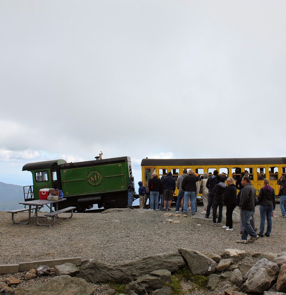
In the meantime, the Holyoke Street Railway wasted no time in building a temporary replacement. This hastily-constructed Summit House opened less than two months later at the end of June, and it consisted of two stories, with a steel frame and corrugated steel walls. It was much smaller than either of its two predecessors, with dancing and dining facilities relocating to Mountain Park, but the new building did offer refreshments and souvenirs, along with telescopes for visitors to use. It was located immediately to the north of the old building, around the spot where these two photos were taken.

Although designed to be temporary, this third building was never replaced by a permanent structure. Mountaintop resorts such as the Summit House were already in decline by the late 1920s, thanks to the increasing popularity of automobiles and the new travel opportunities that they created. The Great Depression, which began just months after the grand reopening, did not help matters either, and by the end of the 1930s both the Mount Tom Railroad and the Summit House had closed.

The railroad tracks were taken up in 1938 or early 1939, and the temporary summit house was dismantled around the same time. The steel beams were sold for scrap, but the corrugated steel panels were unceremoniously dumped over the side of the cliff, where they still remain more than 80 years later. Only the upper railroad station, which was just a little further to the north of here, was left standing, but this burned in 1941.

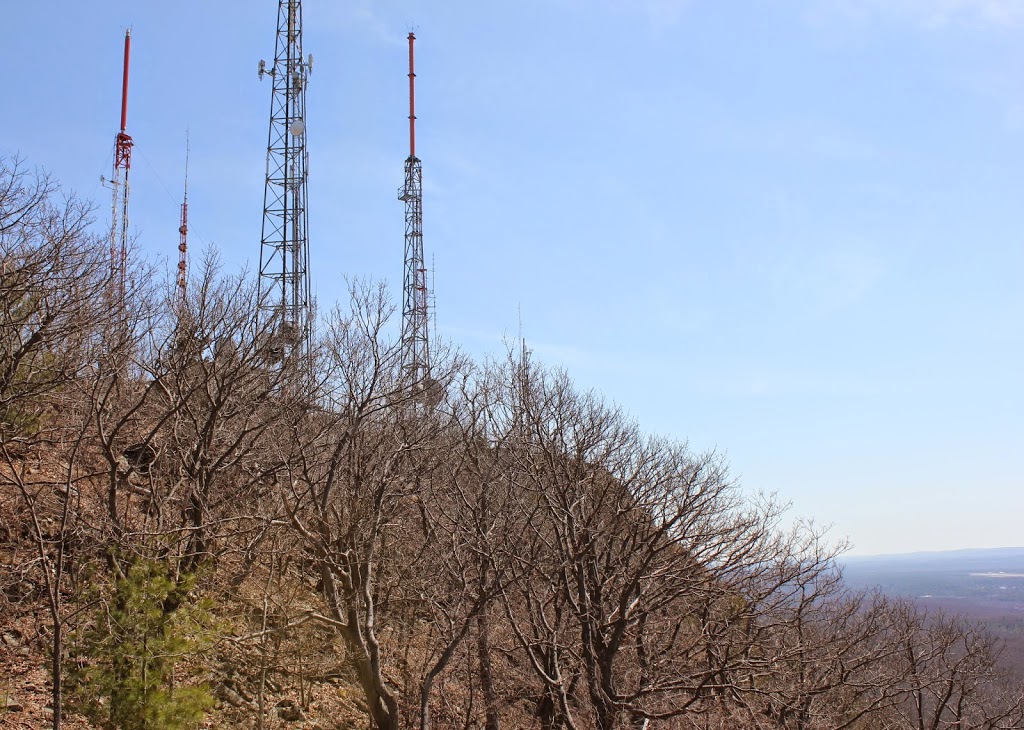
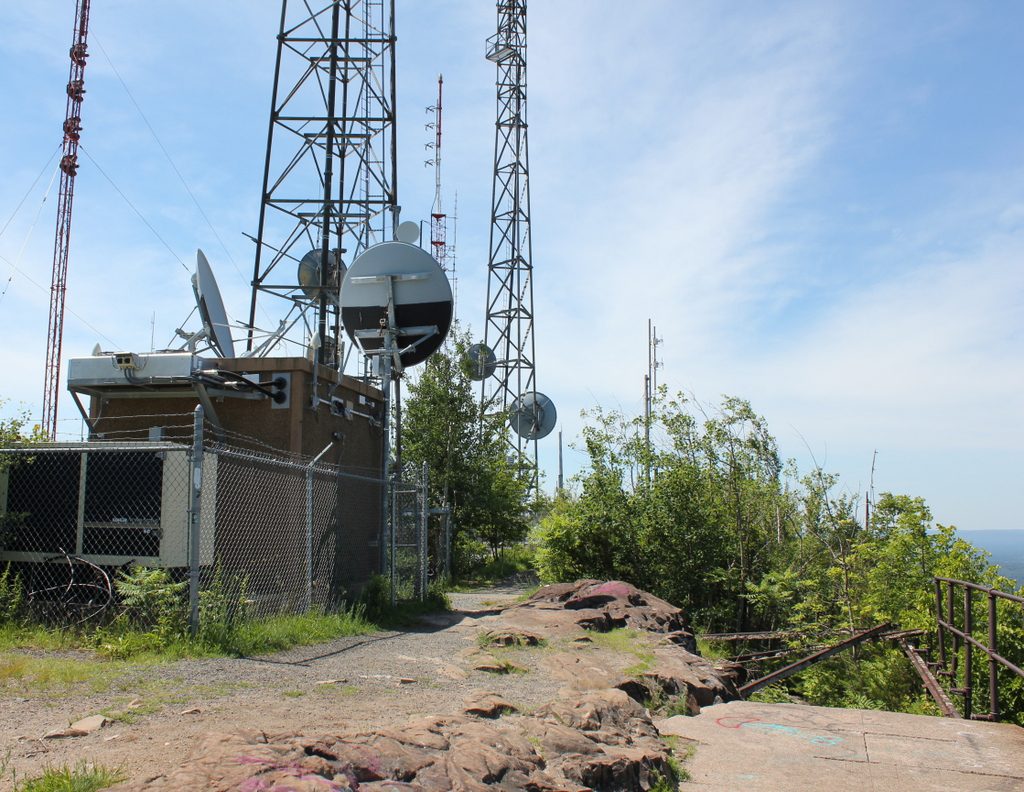
The Holyoke Street Railway continued to operate Mountain Park at the base of the mountain, and the park survived into the late 1980s. However, in 1944 the company sold the summit area to the WHYN radio station. Using the mountain’s elevation to increase its range, WHYN built towers and transmitter buildings here in the foundation of the old Summit House. The old railroad bed was converted into a paved access road, and the project was completed in 1947, when WHYN and two other local stations, WACE and WMAS, began broadcasting from here.

Today, more than a century after the first photo was taken, the summit continues to be used by a variety of radio and television stations. The old Summit House foundation is still there, although it is off-limits to the public and guarded by a barbed wire fence. However, the rest of the summit area is open for hikers, who are able to enjoy the same views that drew tens of thousands of visitors here each year during the early 20th century. And, although much has changed here, there are still some reminders of what used to be here. Most obvious is the boardwalk, which still runs along the western cliff of the summit. Much of it has collapsed, especially here in the foreground, but it stands today as the only surviving feature from the first photo.