North Main Street, Springfield, Mass

Main Street in Springfield, looking toward the North End near Congress Street, around 1882. Photo from Springfield Illustrated (1882).

439_1882c-2Bspringfieldillustrated

The scene in 2023:

The only readily identifiable building in the first photo is on the right side of Main Street, the Hooker School, which was a grammar school that opened in 1865.  In the 1884 King’s Handbook of Springfield, it is described as “the finest of the grammar-school buildings in external appearance,. for which it is indebted to its imposing tower (containing a clock with illuminated dial), as well as to the beautiful network of vines which in summer relieve the bareness of its brick walls.”

The building continued to be used as a grammar school until 1918, and it subsequently became the Continuation School, and then as the girls’ division of the Trade School. It finally closed in 1940, and it was demolished in 1944. Then, about 20 years later most of the surrounding area was demolished as part of an urban renewal plan, which included constructing a large interchange between Interstates 91 and 291, as shown in the second photo.

Springfield Hospital, Springfield, Mass

Springfield Hospital, around 1905-1915. Image courtesy of the Library of Congress, Detroit Publishing Company Collection.

393_1905-1915-2Bloc

The site in 2014, now the home of Baystate Medical Center:

393_2014

From its humble beginnings as Springfield Hospital in 1883, this location has grown into one of the largest hospitals in the state.  The first major expansion happened within 20-30 years of when the first photo was taken, when the building in the 2014 photo opened.  Since then, the hospital has significantly expanded the area behind this building, and the large, grassy area in front of the hospital is now a parking lot.

Mercy Hospital, Springfield, Mass

Mercy Hospital in Springfield, around 1900-1910. Image courtesy of the Library of Congress, Detroit Publishing Company Collection.

Hospitals

The scene in 2014:

392_2014

Mercy Hospital has been at this location on Carew Street since 1898, and treated a number of soldiers returning home from the Spanish-American War.  However, the building on the left-hand side is older than that; it was built as the residence of Haitsill Hastings Allis, a businessman who owned a brick company in Springfield.  The building was sold to the Catholic Church in 1896, and the hospital began working out of the building two years later.  The addition on the right was opened a year later, significantly expanding the number of patients that the hospital could treat.

Today, all of the buildings in the first photo are gone.  The addition was demolished in 1974, and the Allis Mansion itself survived until 2013.  It had been vacant since 2001, and its restoration was unfeasible, so it was taken down to make way for the parking lot in the foreground of the 2014 photo.

Chestnut Junior High School, Springfield, Mass

The Chestnut Junior High School in Springfield, around 1905-1915. Image courtesy of the Library of Congress, Detroit Publishing Company Collection.

391_1905-1915-2Bloc

The scene in 2014:

391_2014

Chestnut Junior High School opened in 1903, at the corner of Chestnut and Prospect Streets in the North End of Springfield.  The building was used as a school for 101 years, before closing in 2004.  In the years after its closing, several redevelopment proposals were floated, including a seemingly promising plan to convert the school into condominiums, much like what was done with Classical High School on State Street in 1986.  Built only a few years before Chestnut, the school was successfully converted into condos, but that would not be the case with this school in the North End.  The building suffered from water damage and other deterioration, so the renovation costs, combined with a less than desirable neighborhood, meant that the proposal went nowhere.  It was vacant until September 2013, when it was destroyed by a fire.  The site has since been cleared, and nothing remains of the historic school building.

North End Bridge, West Springfield Mass

The view looking east over the North End Bridge from the West Springfield side of the river, around 1900-1910.  Image courtesy of the Library of Congress, Detroit Publishing Company Collection.

225_1900-1910-loc.tif

The bridge in 2014:

225_2014

The North End Bridge was the second road bridge to be built across the Connecticut River in Springfield, and opened in 1877.  Both views show the bridge looking east from West Springfield toward Springfield.  This bridge was particularly significant to West Springfield residents, as it directly connected downtown West Springfield to the north end of Springfield and, more importantly at the time, Springfield’s railroad station.

The old bridge was described by King’s Handbook of Springfield in 1884 as being “one of the handsomest highway bridges in the United States.”  In 1923, though, it caught fire and was completely destroyed. Two years later a new bridge was completed, and it remains in use today, carrying US Route 20, the longest road in America, over the Connecticut River.  The road on the far left-hand side just before the bridge in the first photo is Riverdale Street; it didn’t look like much at the turn of the last century, but today it is part of Route 5, and is a major north-south route through the Springfield area.  It does not actually pass through this intersection anymore, though.  The 2014 photo was taken from the center of a rotary, which was built atop a tunnel for Route 5.

As an incidental historical note, there is a sign on the bridge in the first photo, which is barely legible.  In higher-resolution copies of the photo, it reads: “No person shall ride or drive a horse or mule on any part of this bridge at a rate faster than a walk under a penalty of two dollars for each offence.”  Today, the bridge traffic usually travels at a significantly higher rate of speed than a walk, except during rush hour.

Hampden Park, Springfield, Mass

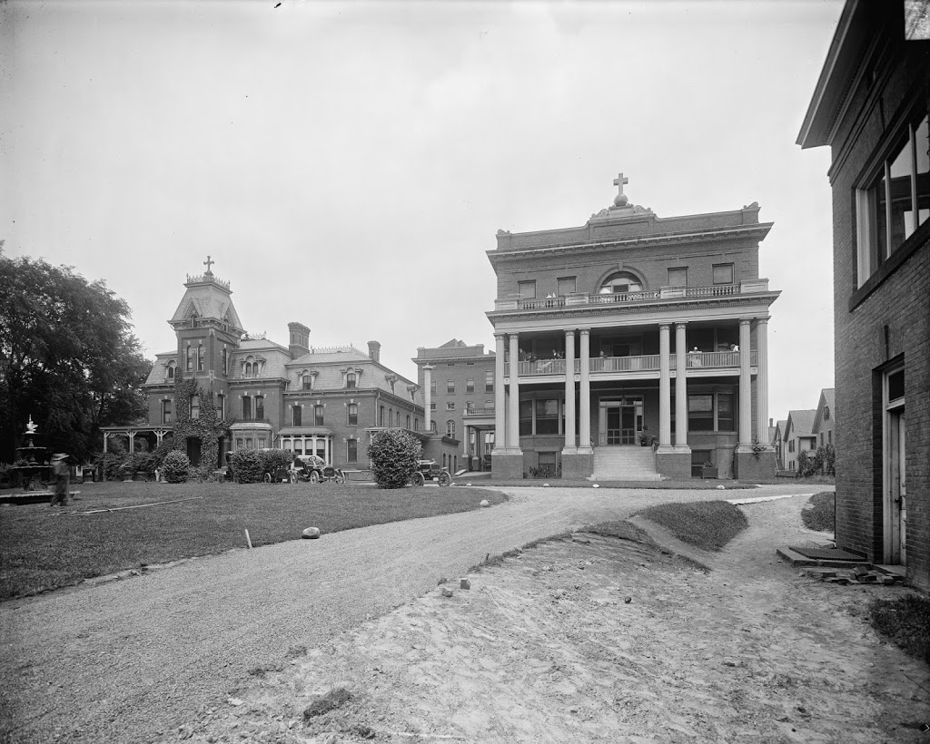
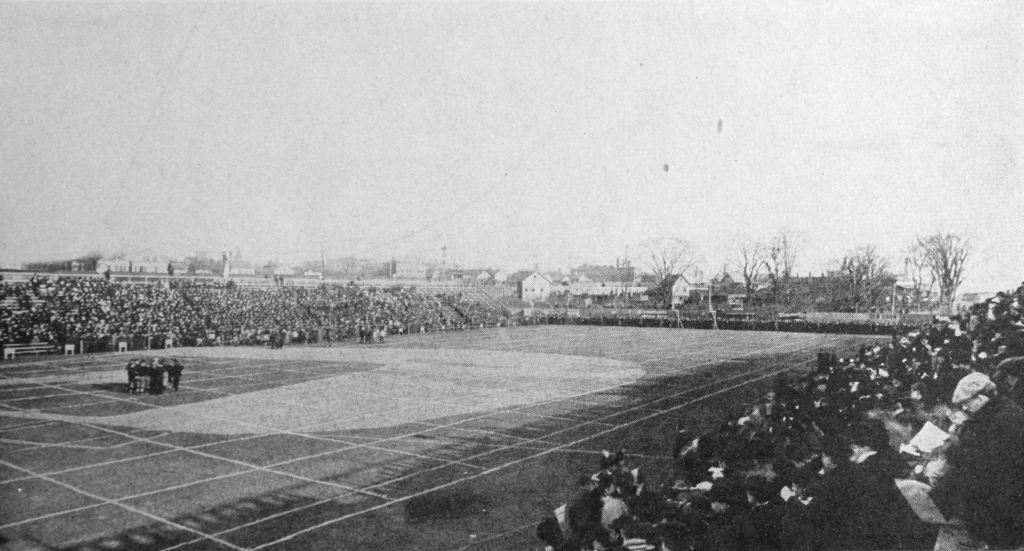
Hampden Park in Springfield, Mass, during a football game, probably around 1905. Photo from Springfield: Present and Prospective, published in 1905.

147_1905c spp

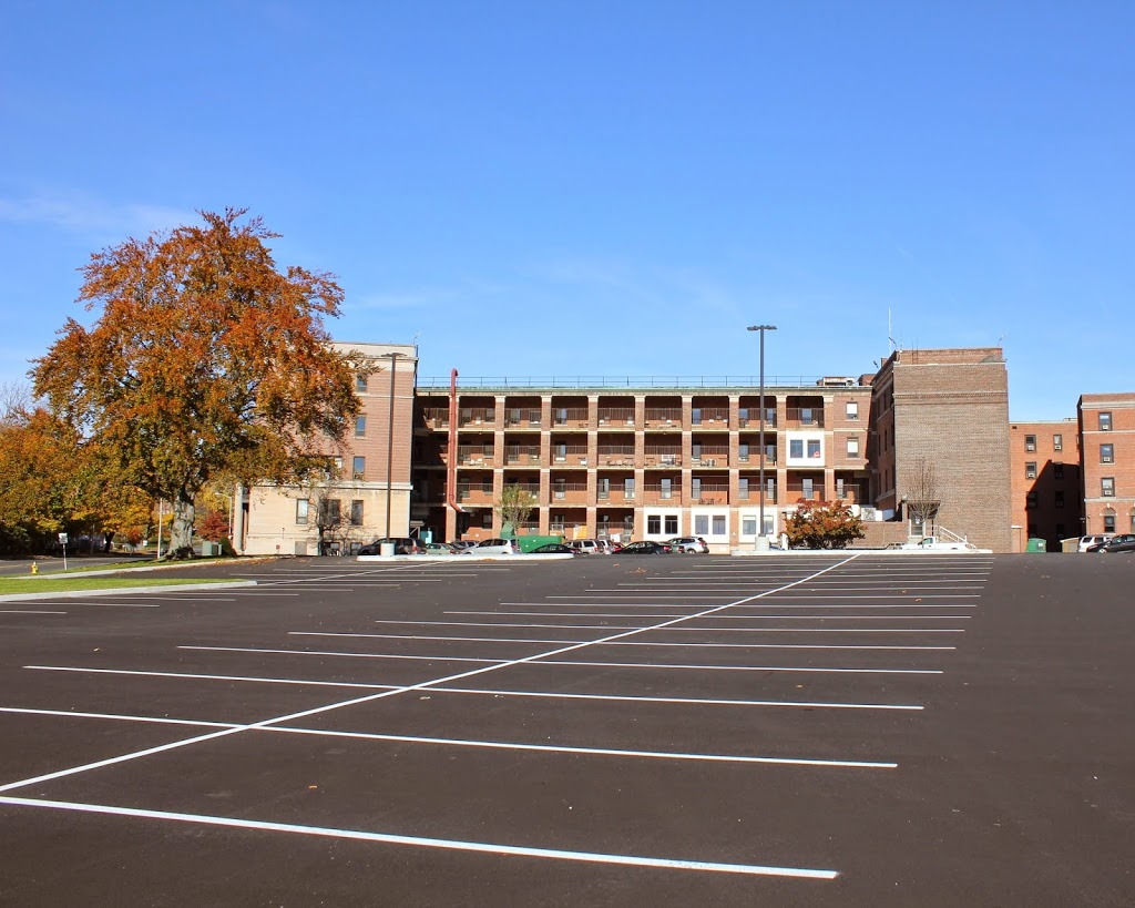
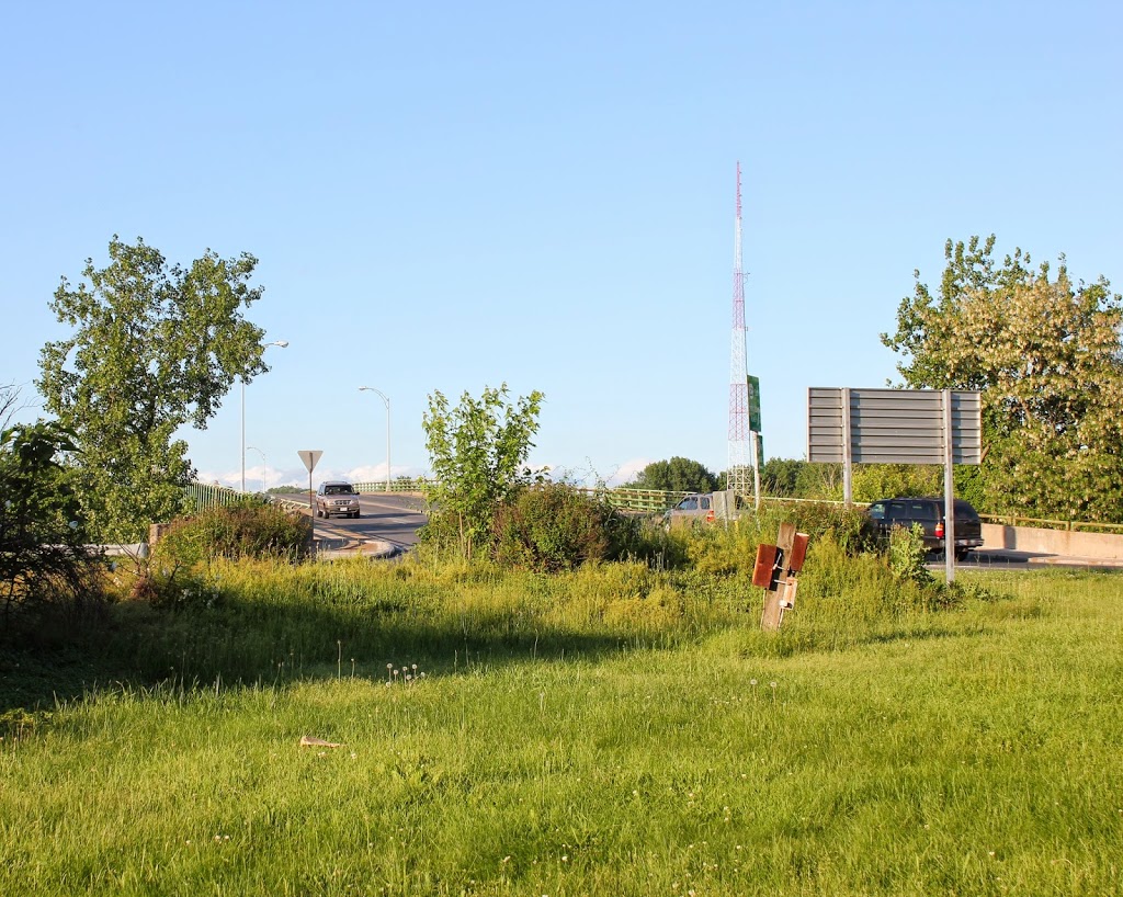
The approximate scene in 2014:

147_2014

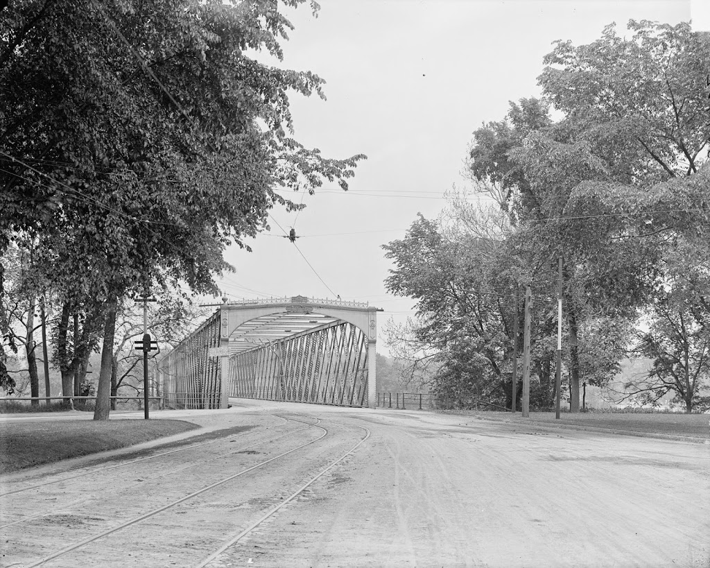
First, a quick explanation: these two photos do not necessarily match up perfectly. They are both oriented in the same direction, but I don’t know whether this particular field was located here, or further south.  The baseball diamond is visible in contemporary maps; an 1899 city map shows it further south, while a 1910 map shows it at approximately the location of the present-day photo.  However, as I don’t know when the transition happened, I am left only to estimate when re-creating the 1905 photo.

In any case, Hampden Park (not to be confused with the major sports arena of the same name in Glasgow, Scotland) was used for a variety of athletic events for over a century.  First opened in the 1850s, the site, bounded by the Connecticut River, the railroad tracks, and Plainfield/West Street (North End Bridge), was originally used for horse and bicycle racing.  In 1861, it was used as the muster grounds for Civil War infantrymen, and later became a baseball field as well. It was here that in 1869, the Cincinnati Red Stockings, baseball’s first openly professional team, played against the Springfield Mutuals.  Cincinnati won 80-5 en route to a perfect 65-0 season.  A few years later, several National Association (the precursor to modern Major League Baseball) games were played here – first the short-lived Middletown Mansfields for a game in 1872, and later, for one game each year in 1873 and 1875, the Boston Red Stockings, now known as the Atlanta Braves, played at Hampden Park.

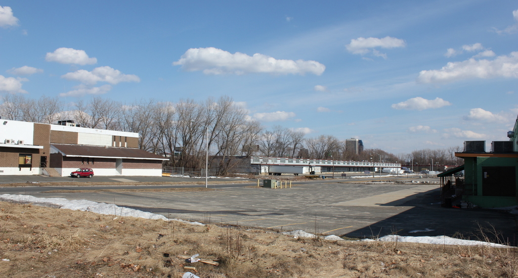
Later on, the park became home to a series of minor league baseball teams, with the location of the field changing several times.  Most recently, it was located in the northwest corner of the lot, closest to the North End Bridge. Built in 1922 as the creatively-named League Park, it was renovated and renamed Pynchon Park in 1940.  This field was home to minor league affiliates for the Cubs and later for the Giants; from 1950 through 1953, they were the Springfield Cubs, Chicago’s AAA affiliate. The last season of Springfield minor league baseball was in 1965, when the AA Springfield Giants played here; the next year, the team moved, and the park burned down.  The present-day photo above was taken from around the left-field corner of the park, with the former location of home plate being being behind me, around where the Pride gas station and convenience store now stands.

In the first photo above, the field is configured for a football game, likely an Ivy League college game.  From 1889 to 1894, the annual Harvard-Yale game was played here, as Springfield was a neutral site in between Cambridge and New Haven; after a particularly violent 1894 game, known as the “Hampden Park Blood Bath,” the game was suspended for two years, and the number of severe injuries called into question the future of the entire sport.  Later on, in 1905 and 1906, Hampden Park hosted the Brown-Dartmouth game, and it is possible that the 1905 game might be the one in the above photo.