First Central Baptist Church, Chicopee, Mass

First Central Baptist Church, at the corner of Broadway and East Streets in Chicopee Falls, around 1892. Image from Picturesque Hampden (1892).

The church in 2018:

The first Baptist organization in Chicopee was established in 1828, back when this area was still part of Springfield. The congregation constructed its first church building in 1832, and it was located just a block away from here at the corner of Maple and Belcher Streets. Chicopee was incorporated as a separate town, and the church became the First Baptist Church of Chicopee. Two years later, the building was moved down the hill to Market Street and enlarged, and the congregation worshiped there for the next 28 years.

In 1878, the First Baptist Church moved back up the hill, constructing this brick High Victorian Gothic-style church building on Broadway. The pastor at the time was Rufus King Bellamy, who had served in this capacity since 1848. He would continue as pastor until 1882, but he would probably be remembered best as the father of novelist and journalist Edward Bellamy, who was one of the most successful American authors of the late 19th century.

Following Reverend Bellamy’s retirement, none of the next few pastors here at First Baptist came close to matching his longevity. By the time the first photo was taken a decade later, the church had seen three new pastors, and it would have two more by the turn of the 20th century. However, this kind of pastoral turnover was not uncommon for churches of the period, and Bellamy’s 34 years in the pulpit was unusually long, even compared with other churches in Chicopee.

In 1931, the First Baptist Church merged with Central Baptist Church, which had been located in the center of Chicopee at the corner of School and Cabot Streets. Central Baptist sold that property, and the united congregation continued to worship here in this church on Broadway, becoming the First Central Baptist Church. Since then, the building has been expanded with an addition to the rear that was built in 1965, but otherwise the historic church is still standing with few alterations to its original exterior. It remains an active church, although it has been renamed again, and it is now the First Central Bible Church.

St. Stephen’s Church, Boston

Looking north on Hanover Street in Boston, with St. Stephen’s Church in the center of the scene, around 1895-1905. Image courtesy of the Boston Public Library.

The scene in 2018:

These photos show the view looking north on Hanover Street from about the corner of Tileston Street, in Boston’s North End. The most prominent building here in this scene is St. Stephen’s Church, which is located directly opposite the Paul Revere Mall. Although it is currently a Roman Catholic church, it was constructed in 1804 as a Congregational church. It was originally known as the New North Church, as opposed to the more famous Old North Church less than 200 yards away, and it was the work of prominent architect Charles Bulfinch, who was responsible for designing many important buildings in early 19th century Boston.

This church was built around the same time that Unitarian theology was causing divisions within Congregational churches across New England. In 1813, New North became Unitarian, as did a number of other Congregational churches in Boston. That same year, 25-year-old Francis Parkman became its pastor. He would go on to serve the church for the next 36 years, and he was also the father of Francis Parkman Jr., who went on to become a noted historian and writer.

By the mid-19th century, the demographics of the North End had changed. As new, more desirable neighborhoods were developed in other parts of the city, affluent North End residents had steadily left the area. These largely Protestant, native-born residents were replaced by Irish Catholic immigrants, who settled in large numbers here in the North End. With its congregants leaving the increasingly crowded and impoverished neighborhood, the New North Church was ultimately sold in 1862 to the Roman Catholic Diocese of Boston, becoming St. Stephen’s Church.

The church building subsequently underwent some changes, including alterations to the original cupola. In 1870, it was moved back 16 feet when Hanover Street was widened, and it was also raised six feet on a new, higher foundation, in order to create a lower level. The interior was also modified, and it saw further changes after being damaged by fires in 1897 and 1929.

The first photo shows the church, and its surroundings on Hanover Street, around the turn of the 20th century. By this point, the North End was no longer predominantly Irish. Instead, the neighborhood was filled with newer immigrant groups, particularly Italians, and the North End was well on its way to becoming known as Little Italy. However, some of the Irish parishioners maintained their connections to St. Stephen’s Church, including John F. Fitzgerald, who was a congressman and mayor of Boston. His daughter Rose – the mother of John F. Kennedy – was baptized here in 1890, and her funeral was held here 104 years later, in 1995.

Out of the five churches that Charles Bulfinch designed in Boston, this church is the only one that survived into the 20th century. By the 1960s it was also one of his few remaining churches anywhere, and it was recognized for its historic and architectural significance. From 1964 to 1965, it underwent a major renovation, which included lowering the building to its original level and restoring the cupola. The interior was also restored during this time, although it is somewhat different from Bulfinch’s original plans.

Today, St. Stephen’s Church is still an active Roman Catholic parish, and the restored building stands as an important architectural landmark in the North End. The surrounding streetscape has seen some changes since the first photo was taken around 120 years ago, with the most obvious being the three buildings on the right side, which were constructed around 1905. Overall, though, this scene has maintained the same scale since the late 19th century, which still consists primarily of four-story brick commercial blocks, and the North End remains a remarkably well-preserved section of Boston.

S. F. Cushman & Sons Woolen Mill, Monson, Mass

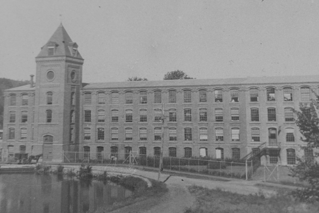
The S. F. Cushman & Sons Woolen Mill on Cushman Street in Monson, probably around 1912. Image courtesy of the Monson Free Library.
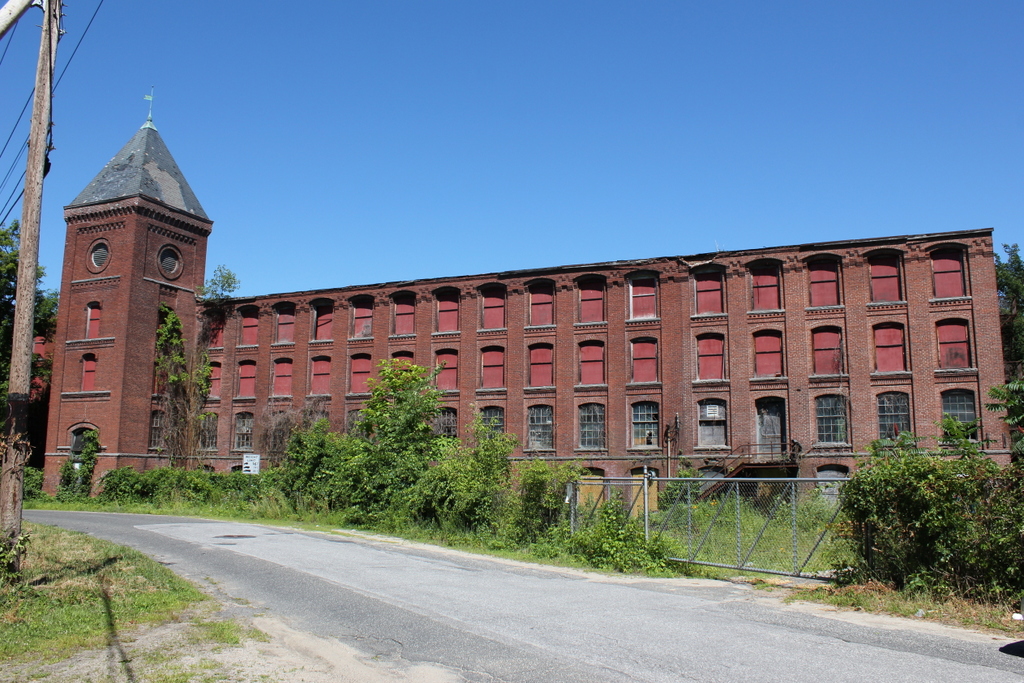
The scene in 2018:

During the 19th and early 20th centuries, the town of Monson had a small but thriving woolen industry, with several factories that were located along the Chicopee Brook. The earliest of these was established around 1800 by Asa Gates, who constructed a mill here on this site. In 1816, this mill was acquired by the Monson Woolen Manufacturing Company, and this firm continued to produce textiles here throughout much of the 19th century. Throughout this time, there were several different buildings here. One was constructed around 1854, but it burned only a few years later, and it was subsequently replaced by another mill in 1858.

In 1877, the Monson Woolen Manufacturing Company was acquired by Solomon F. Cushman, who had been working for the firm since 1856, when he took a job as a bookkeeper after moving here from Monson, Maine. He renamed the company S. F. Cushman & Sons, and in 1883 he expanded it by purchasing another mill on Elm Street, which became known as the Branch Mill. In the meantime, the 1858 mill here on Cushman Street continued to be used to manufacture textiles until 1886, when it too burned. Both this building and its predecessor had been made of wood, but its replacement – shown here in these two photos – was built of brick. This four-story mill was completed later in 1886, and it featured an ornate exterior that was highlighted by a stair tower on the west side of the Cushman Street facade.

Solomon Cushman died in 1900, and his sons took over the business, although just a year later they sold the Branch Mill, which subsequently became the Somerset Woolen Mill. However, they continued to operate the Cushman Street mill for more than a decade, and the 1902 book Our County and Its People: A History of Hampden County provides the following description of this facility:

It contains 5 sets of modern machinery. The mill has made in years past broadcloth, satinets, cassimeres, and doeskins. At present the mill employs about 85 operatives (about evenly divided between men and women) with an annual pay roll of $40,000. The present manufactures are kersey and cloakings.

In 1912, the Cushman brothers sold the property to Heimann & Lichten, a hat manufacturing company whose previous factory, located on Main Street on the present-day site of the town hall, had burned earlier that year. The new owners converted the Cushman Street mill into a hat factory, and the building was evidently expanded around the same time, with the addition of five window bays on the right side. Although it features the same design as the original section of the building, it was constructed with lighter-colored bricks, as shown in these two photos. The first photo was probably taken shortly after this addition was completed, and it also shows the mill pond that was once located on the opposite side of Cushman Street.

Julius Heimann and Morris C. Lichten had been partners in the hat industry since 1884, and in 1890 they began manufacturing in Monson. Following the fire in their original building, they carried on operations here in this mill for several more years. However, both men died only a few months apart. In October 1918, Heimann was killed in a car accident after visiting Lichten in a New York City hospital. Lichten, who had been ill at the time, died the following January, leaving control of the firm to its vice president, Daniel E. Nolan. He would continue to run the company for another nine years, before it closed in 1927.

In 1934, A. D. Ellis Mills, Inc. purchased this property. A. D. Ellis was another major textile manufacturer in Monson, and at the time it operated two other factories, with one on Bliss Street and another on Main Street. This factory was used for storage, and it was owned by by A. D. Ellis until the company dissolved in 1962. The building subsequently changed ownership several more times over the next few years, and in 1966 it was purchased by M & M Chemical Sales Corporation, who occupied it for the next 20 years.

M & M Chemical went bankrupt in 1986, and this property was subsequently sold at auction. However, the building has been vacant ever since, and it has steadily deteriorated after more than 30 years of neglect. In 2010, one of the dormer windows collapsed, sending bricks and other debris onto the street below. This caused a temporary closure of Cushman Street, until the other dormer windows could be safely removed. Otherwise, though, the rest of the building is still standing, with few exterior changes from this angle since the first photo was taken. Today, it is Monson’s oldest surviving factory building, and it is one of the few existing remnants of the town’s industrial heritage.

290-294 Sumner Avenue, Springfield, Mass

The apartment building at 290-294 Sumner Avenue in Springfield, around 1938-1939. Image courtesy of the Springfield Preservation Trust.

The scene in 2018:

This four-story apartment block was constructed in 1917, in a desirable location across Sumner Avenue from the main entrance to Forest Park. According to newspaper advertisements of the late 1910s, the building consisted of four and five-room apartments, and by the 1920 census there were 15 families living here, with a total of 46 residents. These families were generally upper middle class, and included occupations such as a wholesale merchant of automobile supplies, a physician, an insurance agent, a bakery manager, a civil engineer, and a furniture store manager.

The first photo was taken almost 20 years later, in the late 1930s. The 1940 census shows that there were 18 different families living here, with rents that ranged from $39 to $49 per month. Based on their occupations, these residents appear to have been somewhat less affluent than the tenants here in 1920, but they were still solidly middle class. These included a lumber mill engineer, a die sinker at a tool factory, an electrician, a stenographer, a pharmacist, a nurse, an accountant, a librarian, and several teachers. Many of these workers earned over $2,000 per year (about $37,000 today), and the highest-paid resident was the die sinker, Emil J. Hedeen, who earned $3,000 (about $55,000 today) working for the Moore Drop Forging Company.

Interestingly, the majority of the residents were not natives of Springfield, with only 17 of 47 having been born in Massachusetts. Few were immigrants, though; instead, most were out of state, with quite a number of states represented here. The residents were also a mix of those who were single, married, and widowed, but most households were small, with only 2 children under the age of 18 who lived here. However, some of the tenants did sublet space in their apartments to one or two lodgers, who would have helped to offset the cost of the rent.

Today, some 80 years after the first photo was taken, very little has changed in this scene. The exterior of the building has remained well-preserved during this time, and it serves as a good example of the many upscale apartment blocks that were built in Springfield during the early 20th century. The building continues to be used as apartments, with city records indicating that it has a total of 20 units.

Forest Park Fountain, Springfield, Mass

A fountain in Forest Park, around 1905. Image courtesy of the Library of Congress, Detroit Publishing Company Collection.

The scene in 2018:

Forest Park was established in 1884, when Orrick H. Greenleaf donated around 65 acres of land on the south side of Sumner Avenue. Other benefactors soon gave adjoining parcels to the city, but the single largest gift came in 1890, when ice skate manufacturer Everett H. Barney gave nearly 175 acres of what is now the western end of Forest Park. This gift included his home, Pecousic Villa, and its well-landscaped grounds, which featured aquatic gardens, ponds, and the meandering Pecousic Brook. Barney’s only stipulation was that he and his wife would be allowed to live in the house for the rest of their lives, with the city taking possession of it after their deaths.

The first photo shows a view of this section of the park, facing west from the top of a dam on the Pecousic Brook. At the foot of the dam is a small pool lined with stones, with a fountain in the center. Beyond the pool, the brook flows under a simple plank bridge, before rounding a curve to skirt past the aquatic gardens, which are visible in the upper left center of the photo. To the right is a steep hill leading up to a broad plateau, and there is a similar one just out of view on the left, forming a narrow valley for the brook to flow through.

Today, nearly 115 years since the first photo was taken, Forest Park has seen some major changes, but it remains the largest park in the city, and one of its most popular recreation areas. Further upstream of here, there are several more dams and ponds that have been constructed since the early 20th century, but the course of the brook remains largely the same in this scene. The dam is still here, as is the pool, although the perimeter now consists of large rocks, as opposed to the small, round stones of the first photo. However, perhaps the most noticeable change to this scene is the covered pedestrian bridge in the center of the 2018 photo, on the same spot where the plank bridge had once crossed the brook.

Ventfort Hall Library, Lenox, Mass

The library at Ventfort Hall in Lenox, probably around the 1890s. Image courtesy of the Lenox Library Association.

The scene in 2018:

As discussed in more detail in a previous post, Ventfort Hall was completed in 1893 as the summer home of George and Sarah Morgan. The house was subsequently owned by the Bonsal family from 1925 until 1945, and during the second half of the 20th century it was used for a variety of purposes, including as dormitory, hotel, ballet school, and religious organization. It was nearly demolished in the early 1990s, but it was instead preserved and restored, and it is now a museum.

These two photos show the library, which is located on the first floor in the northwest corner of the building. The first photo as probably taken soon after the house was completed, and the room’s appearance highlights the Victorian fashion of having eclectic, cluttered interior spaces. This included a mix of mismatched chairs, along with walls that were nearly hidden by bookcases, paintings, photographs, and knickknacks.

Today, the library has been restored, and it is easily recognizable from its appearance in the first photo. However, unlike most of the other rooms in Ventfort Hall, it is not furnished with period antiques. Instead, as the 2018 photo shows, it is filled with modern tables and chairs, and its modern-day uses now include serving as a gathering space for guided tours of the Ventfort Hall Mansion and Gilded Age Museum.