Lost New England Goes West: US Mint, San Francisco

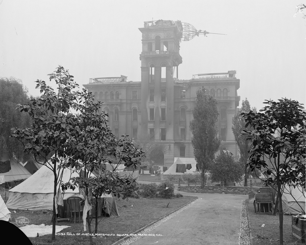
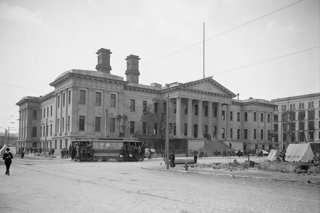
The old San Francisco Mint, located at the corner of Mission and Fifth Streets, in the aftermath of the April 18, 1906 earthquake. Image courtesy of the Library of Congress, Detroit Publishing Company Collection.

877_1906c loc

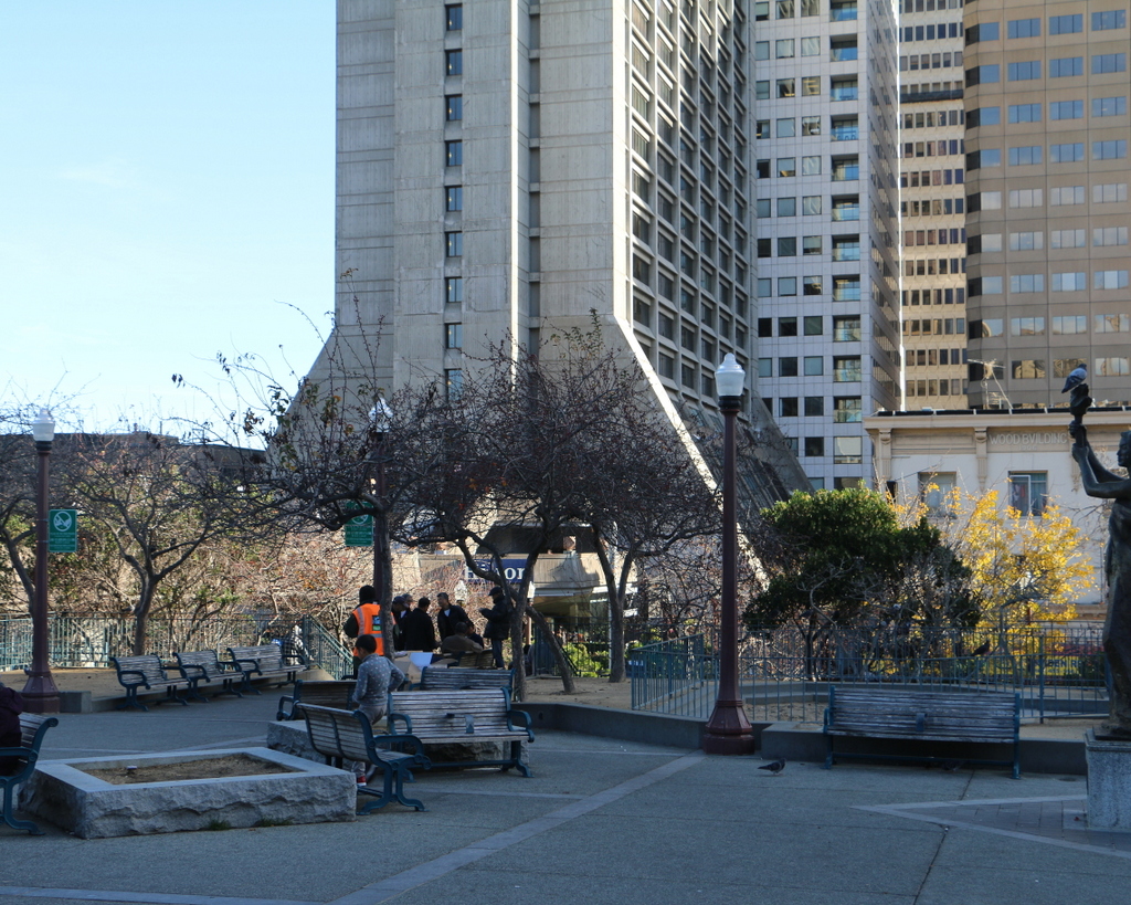
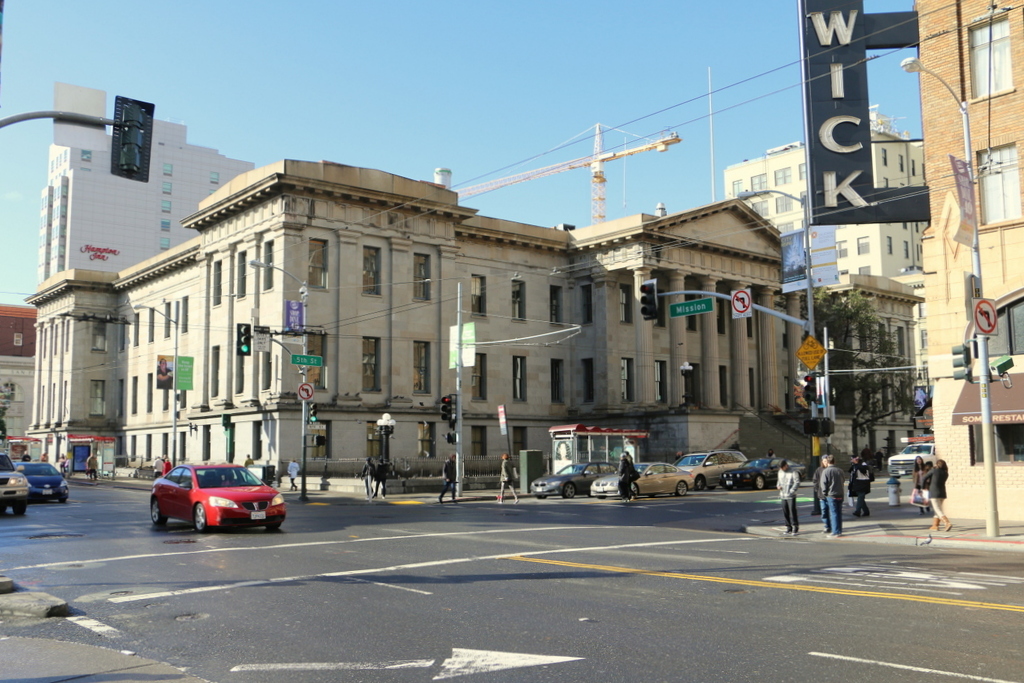
The building in 2015:

877_2015
Amid the rubble and burned-out buildings left behind in the aftermath of the 1906 earthquake, the San Francisco Mint was one of the few buildings in the affected area that survived both the earthquake and the subsequent fires, as the first photo shows. The San Francisco branch of the US Mint was established in 1854 to handle the gold that was mined during the California Gold Rush, and this building opened 20 years later, in 1874.

At the time of the earthquake, the building was one of four US Mint facilities, and in addition to making coins it also held around $200 million in gold, which was a significant portion of the nation’s entire gold reserves. Because of this, its survival in the disaster was of vital importance, and as the fires spread across the city, the mint employees used a well on the property to fight the flames and quickly extinguish any fires that ignited on the building.

Part of the reason for the fire’s destruction across the city was the inept response of the city government, who ordered widespread evacuations instead of using every able-bodied person to assist in the firefighting efforts. This allowed entire neighborhoods to burn almost unopposed, but here at the mint it was a different situation. As a federal building, it was immune from the city’s evacuation order, and because of that its employees were able to save the building even as the city burned around them.

This building functioned as the San Francisco Mint until 1937, when the present-day mint opened on Hermann Street. Today, the old building is still standing. It was sold to the City of San Francisco for one dollar in 2003, and it is now periodically open to the public for different events.

This post is part of a series of photos that I took in California this past winter. Click here to see the other posts in the “Lost New England Goes West” series.

Lost New England Goes West: Hall of Justice, San Francisco

The Hall of Justice at Portsmouth Square in San Francisco, shortly after the April 18, 1906 earthquake. Image courtesy of the Library of Congress, Detroit Publishing Company Collection.

868_1906c loc

The scene in 2015:

868_2015
When the 1906 earthquake hit San Francisco, the Hall of Justice building was just ten years old. Despite what the first photo shows, it actually survived the earthquake itself. It had been seriously damaged, but neither the building nor the 77 prisoners housed on the upper floors were in any immediate danger. In fact, on the first day of the disaster the mayor made the Hall of Justice his temporary headquarters, since City Hall had been completely destroyed.

However, the situation here soon deteriorated. The earthquake had started a number of fires throughout the city, and a series of poor decisions on the part of city officials allowed the fires to spread. One of the ill-fated tactics was to attempt to create firebreaks by destroying buildings. In most cases, though, this was counterproductive, because the explosives tended to do a better job of igniting the buildings rather than destroying them, which only exacerbated the problem.

By nightfall on the first day, the fire was approaching Portsmouth Square, and the Hall of Justice was hastily evacuated. The prisoners were transported to another prison, and the bodies in the morgue and the police records were removed from the building and piled up in the middle of the square, covered in canvas. As the city burned around the square that night, two police officers guarded the pile. There was virtually no water available for firefighting, so the officers emptied bottles of beer onto the canvas to keep it damp, thus saving both the corpses and the records.

The first photo shows Portsmouth Square perhaps a week or so after the fire. By then the bodies and the police records had presumably been moved to a safer location, and the square was instead covered with tents of displaced residents. The burned-out remains of the Hall of Justice loom in the background, with the frame of the cupola dangling from the top of the building. It was beyond saving, and was demolished soon after. Its replacement was completed in 1910 on the same spot, and it stood here until it was demolished in 1968 to build the 27-story hotel that now stands here. Today, the only thing left from the first photo is Portsmouth Square itself, which is a major focal point within the city’s Chinatown neighborhood.

This post is part of a series of photos that I took in California this past winter. Click here to see the other posts in the “Lost New England Goes West” series.

Armory Grounds, Springfield, Mass

Looking north on the Armory grounds from near the center of the Green, around 1910-1920. Image courtesy of the Library of Congress, Detroit Publishing Company Collection.

843_1910-1920c loc

The scene in 2015:

843_2015
This view shows part of the same scene as the photos in the previous post, with part of Officers’ Row visible along the north side of the Green. As mentioned there, these houses were demolished in the 1970s to build the current academic buildings for Springfield Technical Community College after the Armory closed. However, several other buildings from the first photo are still standing today, including the Long Storehouse in the distance, which was built in stages between 1846 and 1863. In front of it are several brick Greek Revival style houses that were built in the 1830s as officers’ quarters. Today, these houses are used by several different campus departments, although only the one in the distance near the center of the photo is visible from this angle; the rest are hidden behind the modern campus buildings.

Officers’ Row at the Armory, Springfield, Mass

Facing east on the Armory grounds along Officers’ Row, around 1910-1920. Image courtesy of the Library of Congress, Detroit Publishing Company Collection.

842_1910-1920c loc

The scene in 2015:

842_2015
The Springfield Armory closed in 1968, and most of the grounds are now the home of Springfield Technical Community College, but most of the property has been well preserved as part of the Springfield Armory National Historic Site. However, this area is the exception, as it has undergone significant changes since becoming a college campus. Located along the north side of the Green, these homes for officers were built between the 1830s and the 1890s, but they were demolished in the 1970s to make room for new academic buildings at the college. In the foreground of the 2015 view is Scibelli Hall (1988), with Deliso Hall (1973) and Putnam Hall (1974) in the distance. The only readily visible building from the first photo that still stands today is the former Administrative Building, now named Garvey Hall. This long building on the east end of the Green was built in 1862, and it now functions as the college’s administrative offices.

View from the Arsenal Tower, Springfield, Mass (5)

Another view looking north from the top of the Arsenal at the Springfield Armory, around 1900-1910. Image courtesy of the Library of Congress, Detroit Publishing Company Collection.

841_1900-1910c loc

The view in 2015, photographed with permission from the Springfield Armory National Historic Site.

841_2015
This scene shows the view looking just a little further to the right than this earlier post, and it shows how both the Springfield Armory and the Liberty Heights neighborhood in the distance has changed over the past century. Aside from the Armory’s Long Storehouse in the foreground, the first photo shows sporadic development throughout the area, with the most noticeable buildings being the factories on the left side. The factories were located along Warwick Street, with the Cheney Bigelow Wire Works on the far left, and the Taber Prang Art Company closer to the center. Beyond them, scattered houses illustrate the early stages of development in the Liberty Heights area, with Mount Tom as a backdrop in the distance.

In the 2015 view, the most obvious change is the building in the foreground. The Springfield Armory closed in 1968, and the grounds became home to Springfield Technical Community College. Most of the former Armory buildings were converted into classroom and office space for the college, but there were also a few new buildings that were constructed for the school, including Scibelli Hall, as seen here. Not much is visible in the distance in the 2015 view, but most of the old factories on Warwick Street from the first photo are still standing. One prominent Liberty Heights landmark that was built after the first photo was taken is the Our Lady of Hope Church, which was built in 1925 and can be seen in the distance just to the left of Scibelli Hall.

For other then and now views from the Arsenal tower, see the earlier posts showing the view facing southwest, west, northwest, and south.

View from the Arsenal Tower, Springfield, Mass (3)

Looking north from the Arsenal tower at the Springfield Armory, around 1882. Image from Springfield Illustrated (1882).

839_1882c spfldillustrated

The view in 2015, photographed with permission from the Springfield Armory National Historic Site.

839_2015
This view from the top of the Main Arsenal tower shows the northwest corner of the Springfield Armory and the Liberty Heights neighborhood in the distance. Both areas have undergone some significant changes, with the most obvious being the large building to the right. Built for Springfield Technical Community College after the Armory closed in 1968, it occupies the ground where several officers’ houses once stood, as seen in the first photo. However, two other historic buildings in this scene survive today. The Long Storehouse, built between 1846 and 1863, is now partially hidden by newer construction, but it still stands along the northern edge of the campus. Just in front of it, in the center of the photo, is the much smaller Master Armorer’s House, a Greek Revival style home that was originally located next to the Main Arsenal before being moved to its current site shortly before the first photo was taken.

It is somewhat hard to tell, but the Liberty Heights neighborhood in the distance has undergone far more drastic changes than the Armory grounds. When the first photo was taken, this area to the northeast of downtown was sparsely populated, with large estates that were owned by wealthy citizens. However, as the city grew, these properties were subdivided and developed with multi-family homes by the early 1900s. The neighborhood changed even further in the late 1960s and early 1970s, when Interstate 291 was built through the area, but today at least one of the historic mid-19th century homes has survived. Built in 1853, the Joshua Bliss Vinton House is barely visible on the extreme left of the 1882 photo, and it is still standing at the end of Underwood Street, where it serves as the rectory for Our Lady of the Rosary Church on Franklin Street. Both the church and the house are mostly hidden by trees in the 2015 scene, but the steeple of the church can be seen on the far left, and just beyond it is the cupola of the house.

For other then and now views from the Arsenal tower, see the other posts showing the view facing southwest, west, south, and north.