School of the Immaculate Conception of Notre Dame, Holyoke, Mass

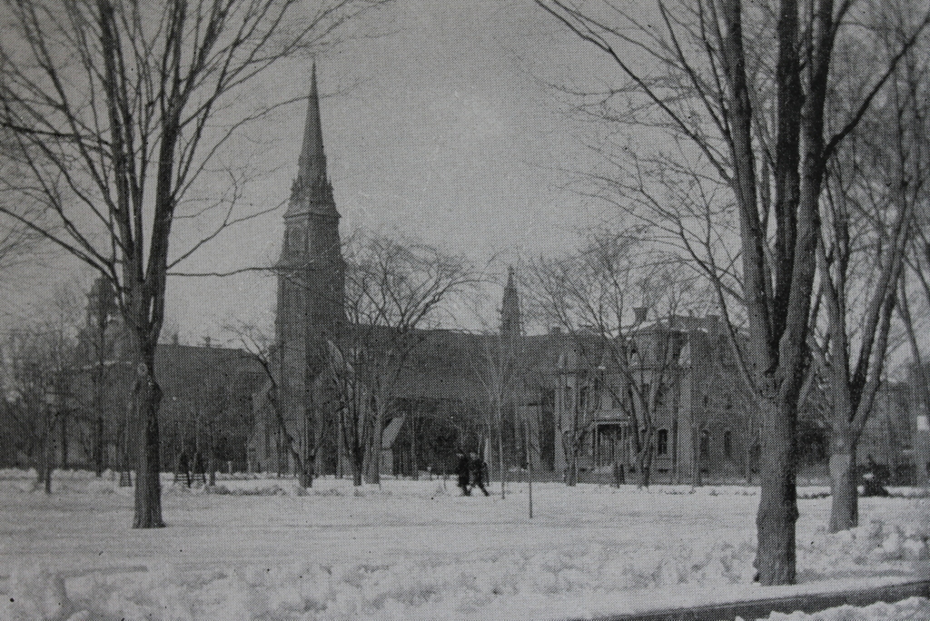
The former School of the Immaculate Conception of Notre Dame, on Chestnut Street opposite Hampden Park in Holyoke, around 1892. Image from Picturesque Hampden (1892).
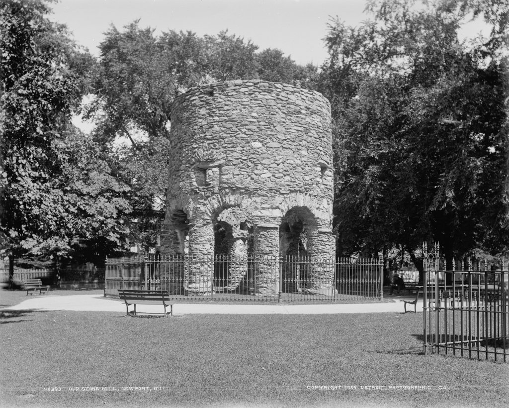
The scene in 2017:

Holyoke grew into a major industrial center during the second half of the 19th century, and the jobs in the mills attracted large numbers of immigrants, particularly the Irish and French Canadians. Most of these immigrants were Catholic, in a region that had previously been almost entirely Protestant, and they soon set about establishing Catholic churches and other religious institutions. The first of these churches was St. Jerome’s, which was established in 1856. Two years later, the parish constructed a church building that still stands at the corner of Hampden and Chestnut Streets, just out of view to the right of this scene.

In 1869, St. Jerome’s Parish opened its first parochial school, the School of the Immaculate Conception of Notre Dame. It was originally an all-girls school, and was located in a wood-frame building that was moved to this site. That same year, the Convent of Notre Dame was completed just to the right of the school. It housed the nuns who taught at the school, and can be seen in the center-right of both photos, with its central tower and Second-Empire style architecture. Then, in 1872, the St. Jerome’s Institute was established as a school for boys, and was located on the other side of Hampden Street, at the corner of Elm Street.

The original Immaculate Conception building was replaced in 1883 by a much more substantial brick school building, which stands on the left side of both photos. It was designed by architect Donat R. Baribault, with an Italianate-style design that included a symmetrical front facade and a tower above the main entrance. By 1890, around the time that the first photo was taken, it had an enrollment of about 550 girls, and the principal of the school was also the sister superior at the adjacent Convent of Notre Dame.

The Immaculate Conception School later became the St. Jerome High School, and in 1963 it merged with several other parish high schools in the city to form Holyoke Catholic High School. The old 1883 school building became part of the Holyoke Catholic campus, and remained in use until 2002, when the school relocated to Granby. Holyoke Catholic has since merged with Cathedral High School in Springfield, and the consolidated school has been known as Pope Francis High School since 2016.

Today, most of the historic 19th buildings from the St. Jerome’s Parish are still standing, including the former Holyoke Catholic buildings. Although they were boarded up for more than a decade after the school moved to Granby, the buildings have since been converted into the Chestnut Park Apartments. This work was completed in 2015, and now there is hardly any difference between these two photos, which were taken 125 years apart. The buildings are now part of the Hampden Park Historic District, which was added to the National Register of Historic Places in 2012.

Soldiers’ Monument, Brattleboro, Vermont

The Civil War monument and bandstand on the town common in Brattleboro, around 1905. Image courtesy of the Library of Congress, Detroit Publishing Company Collection.

The scene in 2017:

Civil War monuments are a near-ubiquitous feature of almost every town common across the country, and Brattleboro is no exception. Dedicated in 1887, the Brattleboro Soldiers’ Monument has a granite base, with bronze plaques on all four sides and an eight-foot-tall bronze infantryman on top. As indicated on one of the plaques, the monument was to commemorate “the loyalty and patriotism of the men of Brattleboro, who fought for liberty and the union in the great rebellion of 1861-1865.” According to the plaque, the town had a total of 381 residents who served in the war, 31 of whom died.

The monument was built at a cost of $6,000, and the June 17, 1887 dedication ceremony drew a number of dignitaries here to the common. It was presided over by Frederick Holbrook, a Brattleboro native who served as governor for the first two years of the war, and whose father once lived in a house across the street from the common. The dedication speech was given by James R. Tanner, a Civil War veteran who had lost both of his legs at the Second Battle of Bull Run. Tanner was the stenographer who had been summoned to Abraham Lincoln’s deathbed in order to record eyewitness testimonies from the assassination, and he later went on to become Commander-in-Chief of the Grand Army of the Republic, serving from 1905 to 1906. Aside from Holbrook and Tanner, other dignitaries included Governor Ebenezer J. Ormsbee, and Brattleboro resident Colonel George W. Hooker, who was later awarded the Medal of Honor for single-handedly capturing 116 Confederate soldiers during the Battle of Crampton’s Gap in 1862.

The dedication ceremony drew about 5,000 people to the common, but an even larger crowd – estimated at 8,000 – gathered here on September 1, 1902, when Theodore Roosevelt gave a speech during a presidential tour of Vermont. This took place only a few years before the first photo was taken, and Roosevelt spoke from the bandstand in the center of the photo, just to the right of the monument. The president was accompanied by a number of notable Vermonters, including Frederick Holbrook, then-Governor William W. Stickney, federal judge Hoyt H. Wheeler, and U.S. Attorney James L. Martin, whom Roosevelt would later appoint as Wheeler’s successor on the bench. Roosevelt was escorted here from the train station, spoke from the bandstand for about 15 minutes, and was presented with a bouquet of roses. He was then escorted back to the station, and from there he traveled south across the border to Northfield, Massachusetts, where he spent the night at the Northfield Hotel.

Today, more than a century after the first photo was taken, this scene has not significantly changed. The old bandstand was evidently replaced at some point, and a different gazebo now stands on the site. Along with this, the cannon and shot are now gone, and its approximate location is now a picnic table. Otherwise, though, this site continues to be used as the town common, and the Soldiers’ Monument still stands here, now accompanied by a second memorial to the Brattleboro residents who were killed in World War I, World War II, the Korean War, and the Vietnam War.

Wells Fountain, Brattleboro, Vermont

The Wells Fountain, at the corner of Putney Road and Linden Street in Brattleboro, around 1905. Image courtesy of the Library of Congress, Detroit Publishing Company Collection.

The scene in 2017:

The Wells Fountain has been a feature here in the center of Brattleboro since 1890, when it was given to the town by William Henry Wells, a New York businessman who had grown up in Brattleboro. The fountain was originally located about 20 feet from here, but it was moved to its current site in 1906. The first photo appears to have been taken shortly before this move, because the photo shows it closer to the street than it is now, so the original location was probably on the far left side of the present-day photo.

The fountain was the the work of William Rutherford Mead, a noted architect who, like Wells, was a Brattleboro native who moved to New York as an adult. Mead was a cousin of President Rutherford B. Hayes, whose family also had roots in Brattleboro, and he was a partner in the prominent architectural firm of McKim, Mead & White. Mead did not have the same architectural genius of his two partners, Charles Follen McKim and Stanford White, and he designed few works on his own. Instead, his talents were as an office manager, serving as a stable, practical-minded counterbalance to the more fanciful McKim and White. Under his leadership, the firm became one of the country’s leading architects of the late 19th and early 20th century, with commissions such as the Boston Public Library, the Rhode Island State House, and Penn Station, along with many other public buildings and Gilded Age mansions.

The original location of the fountain marked the spot where Mead’s older brother, Larkin Mead, had created an eight-foot-high snow sculpture in 1856. The Recording Angel, as it was called, stood here for about two weeks, and the subsequent publicity helped to launch his career as prominent sculptor. He would later go on to design works such as the statue atop the Vermont State House, a statue of Ethan Allen in the United States Capitol, and the statues on Abraham Lincoln’s tomb. He died in Florence, Italy in 1910, and his grave was topped with a replica of his original Recording Angel sculpture.

Today, the Wells Fountain still stands here at the corner of Linden Street and Putney Road, although its surroundings have changed significantly. The trolley tracks in the foreground of the first photo are long gone, as are many of the surrounding buildings. The land just up the hill behind the fountain was once privately owned, with a house that once stood just out of view to the right. However, this land is now a small public park in front of the courthouse, and part of the foundation of the old house can still be seen on the far right side of the present-day photo.

Park Street from Adams Street, Holyoke, Mass

Looking north on Park Street from the corner of Adams Street in Holyoke, around 1892. Image from Picturesque Hampden (1892).

The scene in 2017:

This view shows the scene from Adams Street, looking north toward the triangular park between Park Street (now Clemente Street) on the left and South East Street on the right. Here, the street grid of the South Holyoke neighborhood, which runs parallel to the Third Level Canal, meets the street grid of the rest of the city. This formed a small wedge of land in the center of the photo, just south of Sargeant Street, as well as a larger one just beyond it, in the block between Sargeant and Hamilton Streets. Originally known as Hamilton Park, and later the Hamilton Street Park, this was the largest open space in the neighborhood, and the first photo shows a mix of wood-frame and brick buildings on either side of the street. Further in the distance, in the center of the photo, is the Hamilton Street School, located on part of the triangle between Hamilton, Park, and South East Streets.

When the first photo was taken, this neighborhood was predominantly French-Canadian, although there was also a considerable German population as well. The 1900 census, which was done only a few years after the first photo was taken, gives some interesting insight into this neighborhood. For example, the house on the right was owned by August Ruppert, a 46-year-old German immigrant who ran a grocery store in the first floor of the building. He had immigrated to the United States in 1882, followed a year later by his wife Mary and their two young children, Richard and Annie. They had a third child, Emma, several years years later, and by 1900 they were living here in this house, with Richard working as a plumber and Annie as a weaver in a woolen mill. The census also shows On Wo living right next door at 282 Park Street. A Chinese immigrant, he was about 38 years old, and he worked as a laundryman, probably in the second storefront on the right side of the photo.

Today, nothing is left from the first photo except for the park and the streets themselves. Even then, they have undergone changes, with the Hamilton Street Park becoming Carlos Vega Park in 2012, and Park Street becoming Clemente Street. A 1911 city atlas shows over 40 buildings in this two-block section of Park and South East Streets, but today there are only five, with overgrown vacant lots comprising most of the streetscape. The present-day photo shows the effect that the loss of manufacturing jobs has had on Holyoke, and similar scenes can be found in other once-thriving neighborhoods in the city.

St. Jerome’s Church, Holyoke, Mass

St. Jerome’s Church and Rectory on Hampden Street in Holyoke, around 1892. Image from Picturesque Hampden (1892).

The scene in 2017:

During the mid-19th century, Holyoke was developed into a major industrial center. Many factories were built along the city’s network of canals, and were powered by water from the Connecticut River, which drops 58 feet at the falls between Holyoke and South Hadley. The factories led to a dramatic population growth, particularly with immigrant groups such as the Irish and the French Canadians, who came to Holyoke in search of work, and this led to an abundance of Catholic churches to serve these two predominantly Roman Catholic communities.

The first of these Catholic churches was St. Jerome’s Church, which was established in 1856. The church building, seen here in the center of both photos, was constructed two years later, diagonally opposite Hampden Park at the corner of Hampden and Chestnut Streets. It features a brick, Gothic Revival-style design and, like many other Catholic churches of the era, was designed by prominent Irish-born architect Patrick Keely.

As the Catholic population of Holyoke continued to grow, a number of additional buildings were added around St. Jerome’s Church. The St. Jerome Institute was established as a school for boys in 1872, and was located in a building just to the left of the church, on the far left side of the first photo. Then, in 1879, a Second Empire-style church rectory was built to the right of the church, on the opposite side of Chestnut Street, and is visible on the right side of both photos. Other buildings constructed during this time included the Sisters of Notre Dame Convent (1870), the Convent of the Sisters of Providence  (1886), and the School of the Immaculate Conception (1883), all of which were located across Hampden Street opposite the church, just out of view to the left.

St. Jerome’s Church was significantly damaged by a fire in 1934 that left only the exterior brick walls still standing. However, the building was reconstructed a year later, and it remains in use today as an active Roman Catholic parish. Most of the other 19th century buildings nearby are still standing, aside from the St. Jerome Institute, which was demolished in the late 20th century. Today, these remaining buildings, including St. Jerome’s Church, now form part of the Hampden Park Historic District, which was added to the National Register of Historic Places in 2012.

Newport Tower, Newport, Rhode Island

The Newport Tower at Touro Park, around 1899. Image courtesy of the Library of Congress, Detroit Publishing Company Collection.

The scene in 2017:

This stone tower is generally considered to be among the oldest existing structures in Newport, as well as one of the oldest in the entire state. However, the actual age of the tower has been the subject of much speculation over the years, leading to a number of alternate theories regarding its origins. Conventional historical evidence suggests that it was built in the 1670s as a windmill, but others argue that it is actually much older, with construction variously being ascribed to Vikings, the Knights Templar, medieval Portuguese explorers, and even the Chinese.

The most credible explanation is that the tower was once a windmill that had been built by Benedict Arnold (1615-1678), the colonial president and governor of Rhode Island whose great-grandson of the same name was the notorious traitor of the American Revolution. The tower appears to have been built on his property at some point in the early 1670s, and was mentioned in his 1677 will as “my stone built Wind Mill.” The overall design, with a stone exterior supported by arches on the ground floor, is also consistent with contemporary English windmills, such as the Chesterton Windmill in Warwickshire, which gives further credence to the fact that this tower was a 17th century windmill.

Despite this credible evidence, over the years many have suggested alternate explanations, with probably the most widespread theory claiming that it was built by Vikings during their pre-Columbian explorations of North America. Long considered to be myths, the Norse stories of trans-oceanic explorations were not given much serious attention until 1837, when Danish historian Carl Christian Rafn proposed that these ancient sagas were based on actual voyages to North America. He included the Newport Tower, as well as the nearby Dighton Rock in Massachusetts, as evidence of Norse settlement of the area, and the theory was further popularized by Henry Wadsworth Longfellow in his 1841 poem “The Skeleton in Armor,” where he writes:

There for my lady’s bower
Built I the lofty tower,
Which, to this very hour,
Stands looking seaward.

As it turned out, Rafn was correct about Norse settlement in North America, with archeological evidence verifying that Vikings briefly established a colony in Newfoundland. However, the southward extent of Viking exploration is unclear, and there have been no other definitive archeological finds beyond Newfoundland. There is no evidence that Vikings carved the mysterious Dighton Rock, and the connection to the Newport Tower seems equally spurious. Additionally, the tower bears little resemblance to anything in Norse architecture, while strongly resembling other 17th century English windmills.

Other alternate theories have included speculation that it was built by medieval Scottish Knights Templar, by 15th century Chinese explorers, or by early 16th century Portuguese explorer Miguel Corte-Real. However, all of these theories, including the Viking one, face a number of challenges. Newport was settled by Europeans in 1639, and the island had been thoroughly explored more than a century earlier by Giovanni da Verrazzano, yet there are no surviving accounts of this tower, which would have undoubtedly stood out to early settlers as being highly unusual if it had been there when they arrived. In colonial-era documents,s such as Arnold’s will, it is referred to only as a stone mill, and it would not be for another two centuries after Newport’s establishment that people such as Rafn began to question its origins.

Along with the historical evidence, scientific evidence has also cast serious doubt on the alternate theories and further bolstered the windmill theory. An 1848 study compared the mortar in the tower to that of other 17th century buildings in Newport, and found the samples to have essentially the same composition. Nearly 150 years later, radiocarbon dating futher verified this, finding that the mortar dates back to sometime between 1635 and 1698. Along with this, archaeological digs in the vicinity of the tower have found plenty of 17th century artifacts, but absolutely nothing from earlier centuries.

The tower, along with the surrounding property, was donated to the city in 1854 by Judah Touro, a wealthy New Orleans businessman and philanthropist whose father, Isaac Touro, had been the rabbi of Newport’s Touro Synagogue. This land, located between Mill Street, Pelham Street, and Bellevue Avenue, became Touro Park, with the tower serving as its centerpiece. By the time the first photo was taken at the turn of the 20th century, the tower’s alleged Viking connections were already well-established, and at least one contemporary guidebook, the 1916 A Guide to Newport, mentioned both the Viking and windmill theories, but more strongly argued in favor of the former. Certainly, the romantic appeal of the tower as a place where Viking warriors defended their settlement is far greater than that of a windmill where Benedict Arnold’s ancestors ground cornmeal, but the historical, archaeological, and scientific evidence seems to suggest otherwise.

Today, very little has changed in this scene, nearly 130 years after the first photo was taken. The park’s landscaping is essentially the same, and the tower is still surrounded by a short iron fence, with no changes to the tower itself. Although most likely not a Viking ruin, nor an artifact from some other previously-unknown visitors, the tower is undeniably an important historic landmark as a rare surviving 17th century windmill and one of the oldest structures in the state. Along with the rest of the neighborhood, it now forms part of the Newport Historic District, which was designated as a National Historic Landmark district in 1968.