Lost New England Goes West: Pismo Beach, California

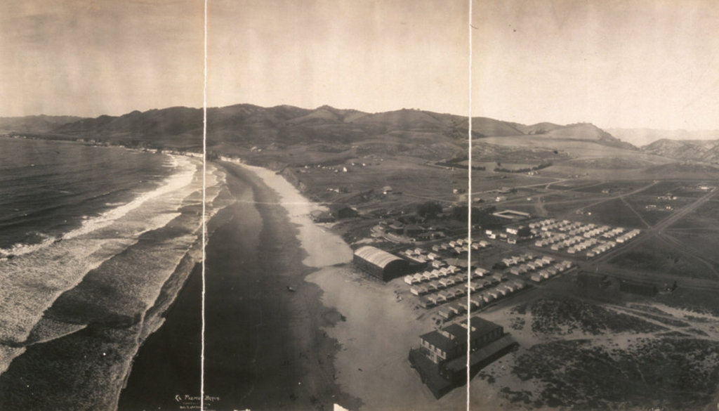
The view looking north along the shore at Pismo Beach, California, around 1906. Image courtesy of the Library of Congress, Panoramic Photographs Collection.

910_1906c loc

Pismo Beach in 2015:

910_2015

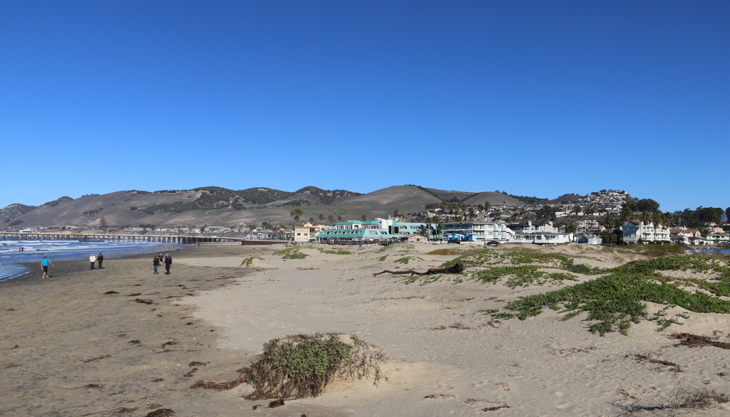
I couldn’t perfectly recreate the first photo, since it was taken a thousand feet or so in the air, but the second photo shows roughly the same view from the ground. The 1906 photo was taken by George R. Lawrence, an early pioneer of aerial photography. He developed what he called a “captive airship,” which was a kite-supported camera that could take pictures up to 2,000 feet in the air, all while being controlled remotely from the ground. In many ways, Lawrence’s invention was an early version of a drone, and like modern-day drones, it was seen as a potential surveillance tool for the military. However, it was also commercially valuable, as demonstrated by Lawrence’s most famous photo, which was taken in the aftermath of the 1906 San Francisco earthquake. He sold prints of this image for $125 each (over $3,000 today), earning around $15,000 from it, or close to $400,000 in 2016.

While he was in California, though, San Francisco wasn’t his only job. Hoping to promote tourism to their new resort, the El Pizmo Beach Company hired Lawrence to photograph Pismo Beach, especially their El Pizmo Inn in the lower right of the photo. The inn included the “Tent City,” which consisted of several block of tents that measured 14 feet by 18 feet and could be rented for $6 per week. Entertainment at the resort included the dance pavilion, which is the building in the lower center of the photo with the cylindrical-shaped roof.

In the 109 years between the two photographs, not much is left from the original image. The hills in the distance have not changed much,but Pismo Beach itself has become the resort city that the 1906 owners of the El Pismo Beach Company probably hoped it would be. In the years after the aerial photo was taken, the tent city continued to grow, attracting many visitors from San Francisco who sought warmer temperatures in the southern part of the state. By the early 1930s, most of the tents were replaced with more permanent cottages, and the dance pavilion burned down in 1945. There are few landmarks left to identify the original image, although, as a point of reference, the pier in the distance on the left side of the 2015 photo is at about the same spot where the dance pavilion once stood.

This post is part of a series of photos that I took in California this past winter. Click here to see the other posts in the “Lost New England Goes West” series.

Lost New England Goes West: Main Cell Block, Alcatraz, San Francisco

Alcatraz guard Carl T. Perrin, on duty on March 21, 1963, the last day of the prison’s operation. Photo taken by Keith Dennison, courtesy of the National Park Service.

909_1963-03-21 nps

The scene in 2015:

909_2015
The corridors between the cell blocks at Alcatraz were named after major streets; this particular one was known as Broadway, and it was the central corridor in the facility, separating blocks B and C. The block had three levels of cells, and most of the inmates were kept in either B or C blocks, with the more isolated D block being used for isolation and punishment, like solitary confinement.

Because Alcatraz was intended for the nation’s most problematic federal prisoners, the prison enforced many strict regulations. Each cell housed only one person, and conversations between inmates were strictly limited to discourage them from coordinating escapes. “Lights out” was at 9:30 P.M., and, unless they worked a prison job, the inmates spent nearly 23 hours a day in their cells, passing the time by reading, smoking, and occasionally playing musical instruments or making artwork. Images of the interior of the cells can be seen in this earlier post and this one.

This post is part of a series of photos that I took in California this past winter. Click here to see the other posts in the “Lost New England Goes West” series.

Lost New England Goes West: Alcatraz Island, San Francisco (3)

Another view of Alcatraz Island from the water, taken in 1938. Image courtesy of the National Park Service.

908_1938 nps

Alcatraz in 2015:

This view is very similar to the one in this earlier post, but the “then” photo here was taken almost 40 years later, once most of the construction on the island had been completed. When the 1938 photo was taken, the island had been operated as a federal prison for about four years, but the island had actually been used as a prison for much longer. The main prison building at the top of the hill had been completed in 1912 as a military prison, replacing a much smaller structure, known as the Citadel, which had stood there since before the Civil War.

To the left of the main prison is the lighthouse, which was built in 1909 after the previous one had been damaged in the 1906 earthquake. Next to the lighthouse is the burned-out remains of the Warden’s House. This mansion had been built in the 1920s, and was home to the various wardens until the prison closed in 1963. Along with several other buildings on Alcatraz, it was burned in 1970, during the Native American occupation of the island, and today only the shell remains. Right along the water is Building 64, which was built in 1905 and housed officers and their families, and to the right is the 1857 guardhouse, the oldest surviving building on the island.

This post is part of a series of photos that I took in California this past winter. Click here to see the other posts in the “Lost New England Goes West” series.

Lost New England Goes West: Alcatraz Guardhouse, San Francisco

The view on Alcatraz next to Building 64, facing toward the guardhouse, in 1937. Image courtesy of the National Park Service.

907_1937 nps

The view in 2015:

907_2015
As mentioned in an earlier post, the guardhouse in the center of this scene is the oldest surviving building on Alcatraz Island. It was built around 1857 as part of the Army’s initial fortification of the island, back when Alcatraz was seen as a valuable defensive position rather than as a prison. However, it did not take long for the Army to realize the value of the isolated island’s potential as a prison, and the guardhouse here was also used to house inmates.

Over the years, more buildings were added to the island, including Building 64 on the left side of the photo, which was built in 1905 to house the officers who were stationed on the island, along with their families. When the first photo was taken, the prison had been recently transferred to the Department of Justice, who used it to house the most difficult federal prisoners in the country. Many notorious criminals passed through here on their way to the main prison building, including Al Capone, Whitey Bulger, Arthur Barker, Alvin Karpis, and Machine Gun Kelly. The prison closed in 1963 because of the high operating costs, and today it is open to the public as part of the Golden Gate National Recreation Area.

This post is part of a series of photos that I took in California this past winter. Click here to see the other posts in the “Lost New England Goes West” series.

Lost New England Goes West: Alcatraz Dining Hall, San Francisco

The dining hall at the Alcatraz Federal Penitentary, sometime between 1933 and 1963. Image courtesy of the National Park Service.

906_1933-1963c nps

The dining hall in 2015:

906_2015
This dining hall is part of the main prison building at Alcatraz, which first opened in 1912 as a military prison. The first photo, taken during its time as a federal civilian prison, shows the dining hall set up for some sort of holiday dinner. All of the inmates ate their meals here together, and the food was supposedly the best in the entire federal prison system. Meals were 20 minutes long, and inmates could help themselves to as much food as they wanted, provided that they ate it in time and left no waste.

In the distance on the far left of the 2015 photo is the breakfast menu from March 21, 1963, the prison’s last day in operation. The meal consisted of assorted dry cereals, steamed whole wheat, scrambled eggs, milk, stewed fruit. toast, bread, butter, and coffee. Today, the dining hall is one of the stops on the self-guided tour of the island, which is operated by the National Park Service as part of the Golden Gate National Recreation Area.

This post is part of a series of photos that I took in California this past winter. Click here to see the other posts in the “Lost New England Goes West” series.

Lost New England Goes West: Clarence Anglin’s Cell, Alcatraz, San Francisco

Cell #152 in Alcatraz, shortly after Clarence Anglin’s attempted escape in June 1962. Image courtesy of the National Park Service.

905_1962 nps

The cell in 2015:

905_2015
Clarence Anglin and his brother John were convicted bank robbers whowere both incarcerated at Alcatraz. As explained in more detail in the previous post, they participated with their friend Frank Morris in what was possibly the only successful escape attempt from the prison. The first photo was taken in Clarence’s cell shortly after the escape was discovered, and the second one shows the cell as it appears today, complete with a replica of the dummy head that Anglin created to hide their disappearance.

In over 50 years since their disappearance, there have been no confirmed sightings of the three men, nor were their bodies ever discovered, which has led to plenty of speculation and reported sightings ever since. Perhaps the most interesting piece of evidence to surface recently, though, is a 1975 photo that was released last year, which supposedly shows the Anglin brothers in Brazil. Despite the resemblance to the escaped convicts, it remains inconclusive, but it is certainly possible that the men, now in their mid-80s, could still be alive and hiding in South America.

This post is part of a series of photos that I took in California this past winter. Click here to see the other posts in the “Lost New England Goes West” series.