Forest Park Lily Ponds, Springfield, Mass

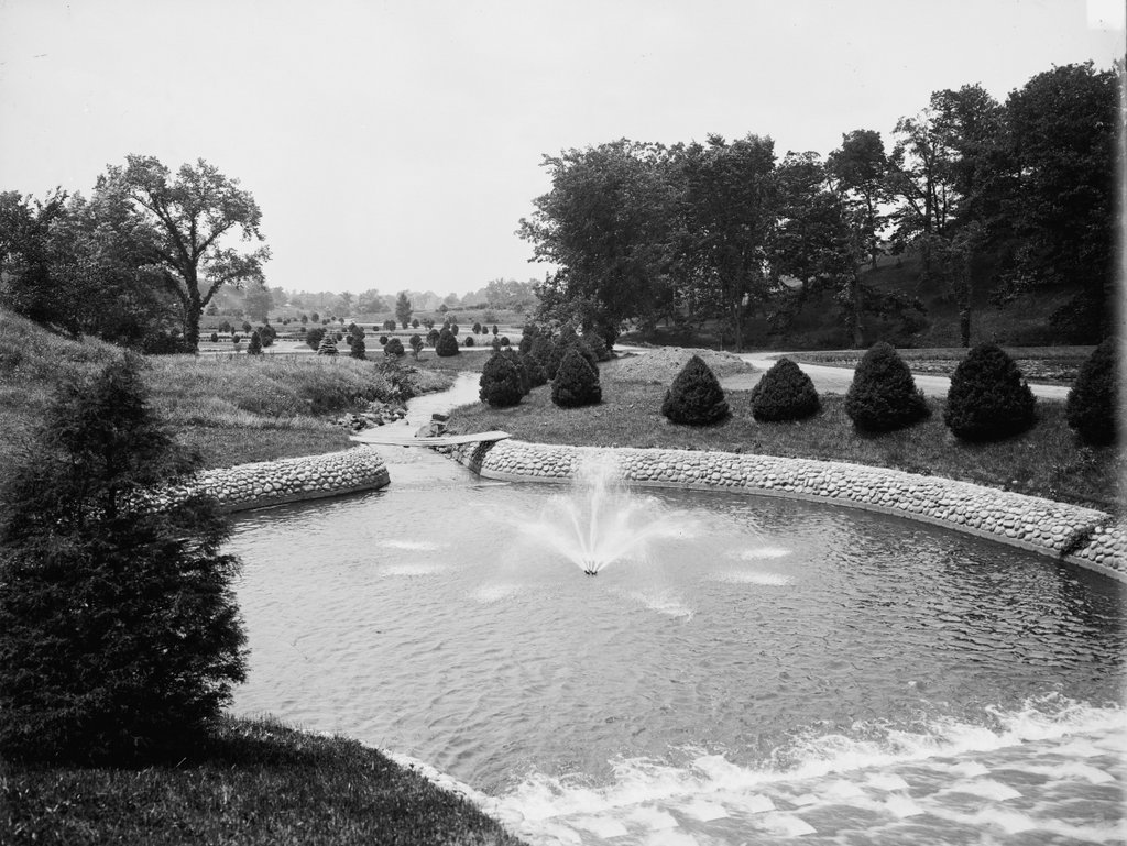
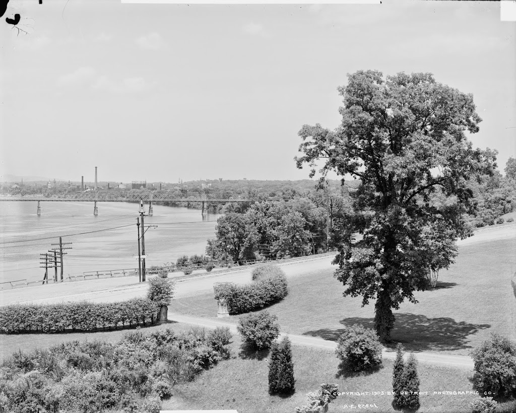
The lily ponds in Forest Park in Springfield, around 1907. Image courtesy of the Library of Congress, Detroit Publishing Company Collection.
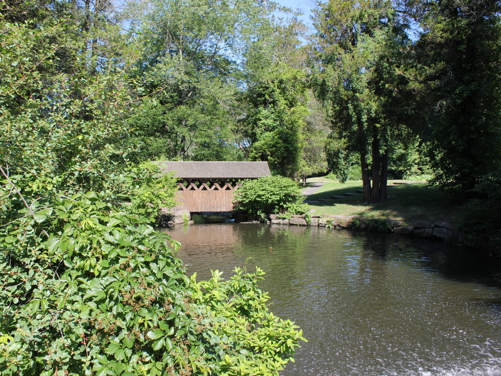
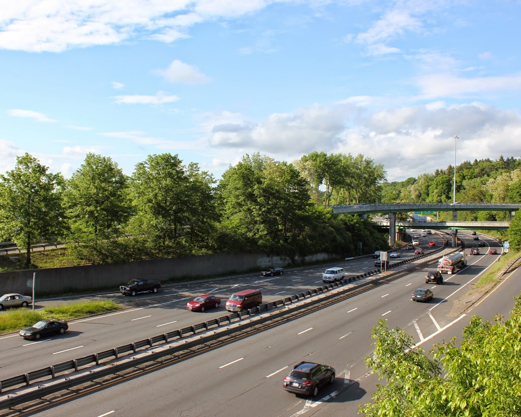
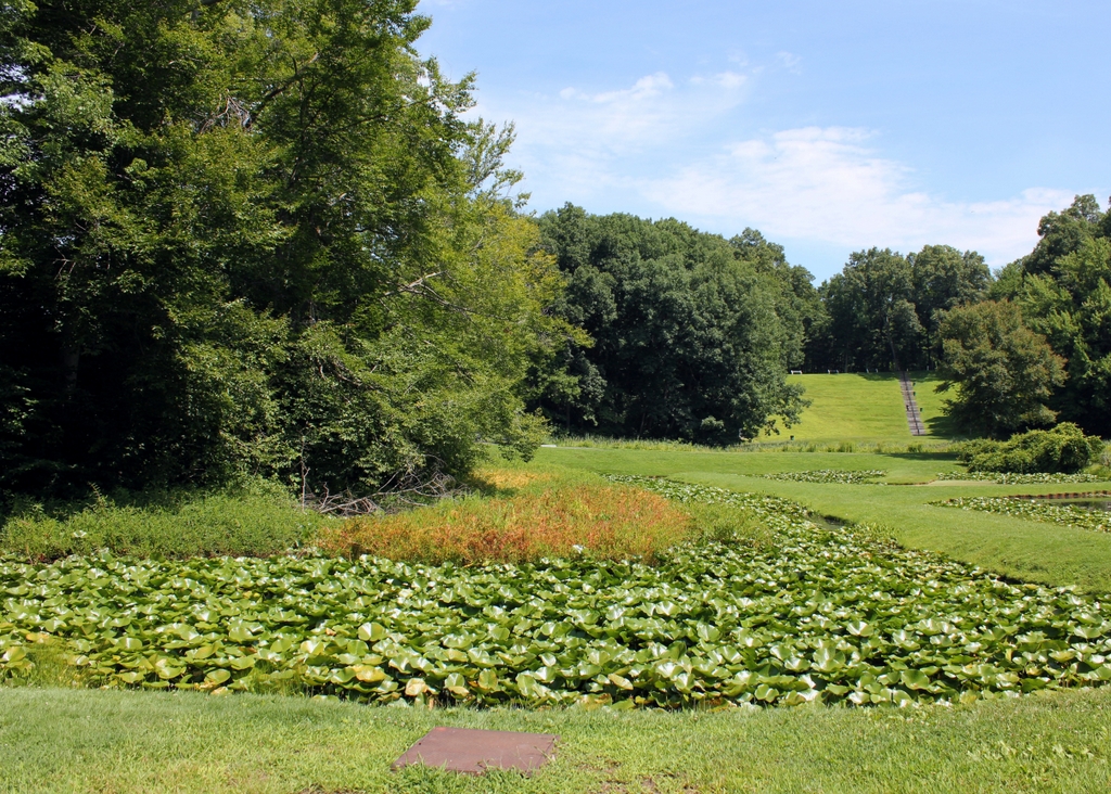
The scene in 2018:

Forest Park is the largest public park in Springfield, encompassing 735 acres of land in the southwestern corner of the city. The origins of the park date back to 1884, and over the years it has been steadily expanded through various donations and land purchases. One of the most significant of these donors was Everett H. Barney, a local ice skate manufacturer who owned much of what is now the western section of the park. He built his house, Pecousic Villa, on the property in 1883, and he subsequently landscaped the grounds with ponds, fountains, a waterfall, bridges, and a network of paths.

Barney had intended to construct a house here for his only child, George. However, George died in 1889, and Barney instead built a mausoleum for his son on the site of what would have been his house. With no other heirs, Barney donated his entire estate to the city, including the house and the meticulously-maintained grounds. His only stipulation was that he and his wife Eliza would be able to reside in the house for the rest of their lives, and they went on to live here until her death in 1905 and his in 1916.

The first photo was taken sometime around 1907, showing the lily ponds that Barney had constructed. It was taken from the path between the lily ponds and the Pecousic Brook, and the view faces north, with Pecousic Villa just out of view on the far left side, on the other side of the hill. Unlike the other sections of Forest Park, which were left in more or less a natural state, this scene was mostly artificial, and the plan was not necessarily admired by all. For example, in 1901 the Springfield Republican published a lengthy commentary on the park, in which it lamented that “Not all the changes of recent years have been for the better.” The article went on to explain:

Everyone must admire the enthusiasm with which Mr. Barney has cultivated the extensive grounds which he has generously added to the park, and criticism of the results would be a most ungrateful task, yet it must be clear from the principles which have been indicated, that a somewhat difficult problem is raised by the conflicting ideals which have been pursued. The rare beauty of the lotus and lily ponds is undeniable, but the general scheme of the park and that of Mr. Barney’s very valuable addition are incongruous. In the park the effort has been to keep as much of nature as is possible in a city park. Mr. Barney’s plan, carried out with diligent personal attention through many years, has involved a design which, though not conventional, is at least artificial.

This criticism notwithstanding, Forest Park proved to be a popular recreation area, with most visitors evidently remaining unfazed by the inconsistencies between the more natural eastern half of the park and the carefully-manicured areas here in the western half. One of the city’s other newspapers, the Springfield Union, praised Barney for his landscaping work in his obituary in 1916, writing:

Forest Park is Springfield’s great breathing ground, and a trip there always includes a visit to “Barney’s front yard.” There he showed his passionate love for nature and that he was an expert horticulturalist. He planted there rare shrubs and trees from Europe, Egypt, China, Japan and India, and there he planned and maintained lily ponds containing nearly all varieties of lilies. There, too, he maintained a lotus pond. Mr. Barney’s nature was a restless, untiring one, and he changed his lawns and flower gardens frequently. His taste ran strongly to mathematical arrangement of flower beds and shrubs, and one is constantly startled by coming suddenly on a stone deer or other piece of statuary.

Today, more than a century after the first photo was taken, Forest Park has undergone some significant changes, including the demolition of the Barney house in the late 1950s to make way for Interstate 91. However, many other scenes in the park, including this one, have remained largely the same. Forest Park is actually much more forested now than it was when it acquired its name, and there are far more trees in the present-day photo, including in the foreground and on the distant hillside. Overall, though, Barney’s lily ponds still look as they did when he first laid them out in the late 19th century, and much of his other landscaping work remains intact after having been enjoyed by many generations of Springfield residents.


Forest Park Fountain, Springfield, Mass

A fountain in Forest Park, around 1905. Image courtesy of the Library of Congress, Detroit Publishing Company Collection.

The scene in 2018:

Forest Park was established in 1884, when Orrick H. Greenleaf donated around 65 acres of land on the south side of Sumner Avenue. Other benefactors soon gave adjoining parcels to the city, but the single largest gift came in 1890, when ice skate manufacturer Everett H. Barney gave nearly 175 acres of what is now the western end of Forest Park. This gift included his home, Pecousic Villa, and its well-landscaped grounds, which featured aquatic gardens, ponds, and the meandering Pecousic Brook. Barney’s only stipulation was that he and his wife would be allowed to live in the house for the rest of their lives, with the city taking possession of it after their deaths.

The first photo shows a view of this section of the park, facing west from the top of a dam on the Pecousic Brook. At the foot of the dam is a small pool lined with stones, with a fountain in the center. Beyond the pool, the brook flows under a simple plank bridge, before rounding a curve to skirt past the aquatic gardens, which are visible in the upper left center of the photo. To the right is a steep hill leading up to a broad plateau, and there is a similar one just out of view on the left, forming a narrow valley for the brook to flow through.

Today, nearly 115 years since the first photo was taken, Forest Park has seen some major changes, but it remains the largest park in the city, and one of its most popular recreation areas. Further upstream of here, there are several more dams and ponds that have been constructed since the early 20th century, but the course of the brook remains largely the same in this scene. The dam is still here, as is the pool, although the perimeter now consists of large rocks, as opposed to the small, round stones of the first photo. However, perhaps the most noticeable change to this scene is the covered pedestrian bridge in the center of the 2018 photo, on the same spot where the plank bridge had once crossed the brook.

Springfield & Connecticut River from Forest Park (2)

Looking north up the Connecticut River toward downtown Springfield, from Laurel Hill in Forest Park, around 1905. Image courtesy of the Library of Congress, Detroit Publishing Company Collection.

The scene in 2018:

These photos were taken from the same spot as the ones in a previous post, but they show the view looking a little further to the left, directly up the Connecticut River. The location of these photos is Laurel Hill, a bluff on the western end of Forest Park. It was once part of the estate of Everett H. Barney, a wealthy ice skate manufacturer who built his mansion, Pecousic Villa, nearby in 1883. He had intended to build a second home here on Laurel Hill for his only child, George, but George died in 1889 at the age of 26, and Everett instead build a mausoleum here on the hill.

A year later, Everett donated his property – which included the house, a carriage house, and meticulously-landscaped grounds – to the city. This land became part of Forest Park, which had been established 1884 after another benefactor, Orrick H. Greenleaf, gave what is now the eastern section of the park. Barney’s gift extended the park all the way west to the Connecticut River, and his only stipulation was that he and his wife be allowed to live at Pecousic Villa for the rest of their lives.

Perhaps the most scenic part of the newly-expanded park was here at Laurel Hill, where an overlook near the mausoleum provided sweeping views of the Connecticut River and downtown Springfield. In the foreground of the photo is the western entrance to the park, flanked by hedges and a pair of stone markers with the letter “B” carved into them. Longhill Street runs across the foreground, along with trolley tracks that are barely visible in the road. More noticeable from this angle are the poles that supported the overhead wires for the trolleys. The railroad also passed through this scene, although the tracks are hidden from view because they ran further down the embankment between the street and the river.

In the center of the first photo is the South End Bridge, an iron truss bridge that was completed in 1879. It was the third bridge across the river in Springfield, after the Old Toll Bridge in 1805/1820 and the North End Bridge in 1877, and it provided direct access to the city from Agawam and points to the south and west, replacing an earlier ferry that had operated here. Just beyond and to the left of the bridge is the mouth of the Westfield River, which is one of the largest tributaries of the Connecticut River.

Further upstream from the bridge is downtown Springfield, which is marked by an assortment of church steeples and smokestacks. The white, wooden steeple of Old First Church is visible in almost the exact center of the photo, and just to the right of it is the granite tower of the Hampden County Courthouse. Other identifiable steeples include, from left to right, those of St. Joseph’s Church, St. Michael’s Cathedral, Church of the Unity, and South Congregational Church. Aside from these churches, another major landmark is the main arsenal of the Springfield Armory, which is visible to the right, on a bluff overlooking the city.

In the nearly 115 years since the first photo was taken, this scene has undergone some dramatic changes. The most obvious of these is the construction of Interstate 91, which now passes through the narrow space between Laurel Hill and the Connecticut River. This section of the highway was built in the early 1960s, and the project required the demolition of Pecousic Villa, which had been  acquired by the city after Everett Barney’s death in 1916. However, the carriage house was spared, and it still stands on the bluff, just out of view on the far right side of the scene. Both the mausoleum and the overlook on Laurel Hill are also still part of Forest Park, although the modern-day view lacks the same picturesque attributes of the first photo.

Aside from Interstate 91, another major change to this scene is the South End Bridge. Also known as the Julia B. Buxton Bridge, the present-day South End Bridge was completed in 1954, replacing the old 1879 bridge from the first photo. Further in the distance, the Springfield skyline is also very different from the early 20th century. For many years, the city had no skyscrapers because of height restrictions, but these were lifted in 1970 with the construction of the 371-foot Tower Square, which is visible in the center of the 2018 photo. Several other skyscrapers would be built in the ensuing years, including the Monarch Place office building to the right of Tower Square, and the Chestnut Park apartment building a little further to the right.

Despite all of these changes, though, there are some surviving landmarks from the first photo. The churches are no longer the dominant features in the skyline, yet some of them are still standing, including Old First Church, St. Michael’s Cathedral, and South Congregational. The old courthouse is also still there, as is the Armory, but these older buildings are now joined in this scene by modern hotels, office buildings, parking garages, and the silver dome of the Basketball Hall of Fame.

Springfield & Connecticut River from Forest Park

The view looking toward Springfield from atop Laurel Hill in Forest Park, around 1905. Image courtesy of the Library of Congress, Detroit Publishing Company Collection.

224_1905c-loc.tif

The same view in 2014:

224_2014

While driving along Interstate 91 through the Longmeadow curve, there is a semicircular retaining wall built into the side of the hill, with a flagpole on top.  I had never paid much attention to it, but when I came across the first photo above, I wondered if that is where it was taken from.  As it turns out, this overlook is part of what is called Laurel Hill, and is the section of Forest Park where the Barney Mausoleum is built.  From the Mausoleum, it is just a short path to this overlook, which once offered views of the city of Springfield and the Connecticut River.  Today, neither the city nor the river is visible from this spot, and the small dirt road barely visible in the 1905 photo is now Interstate 91.

From a traffic perspective, this is a major bottleneck in the Springfield area.  Route 5 and I-91, which are combined in this short section, serve as the primary north-south transportation corridor in western New England, and link Springfield to Hartford and points south.  However, because of the tight fit in trying to squeeze an interstate highway between the hills on the right and the railroad tracks on the left, I-91 is reduced to just two lanes, and that, combined with the many on/off ramps and curves, makes this a common site of traffic jams and accidents.  It all looks so much more peaceful 100 years ago.

Sumner Avenue, Springfield Mass

Looking east on Sumner Avenue, Springfield Massachusetts, from near the intersection with present-day Washington Road, around 1900-1910. Image courtesy of the Library of Congress, Detroit Publishing Company Collection.

223_1900-1910-loc.tif

The same view in 2014:

223_2014

Sumner Avenue is the primary thoroughfare across the southern part of Springfield, passing through the Forest Park neighborhood.  At the time that the first photo was taken, this was a prominent, expensive neighborhood with large, ornate houses, similar to the ones seen on Maple Street and other parts of the city.  However, like many of these other areas, the neighborhood has declined, with most of the wealthy residents moving to Longmeadow or somewhere else outside the city.  Today, most of the houses are still there, though, including the Smith Platt House on the extreme left, and the Lathrop House next to it.