Main Street, Springfield, Mass

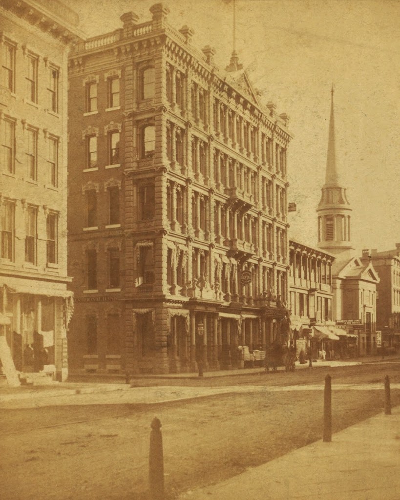
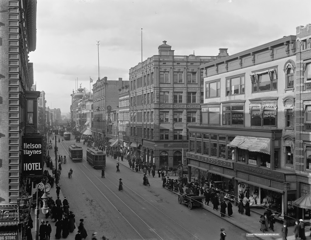
The view looking north on Main Street toward Elm Street and Court Square, around 1865-1875. Photo courtesy of New York Public Library.
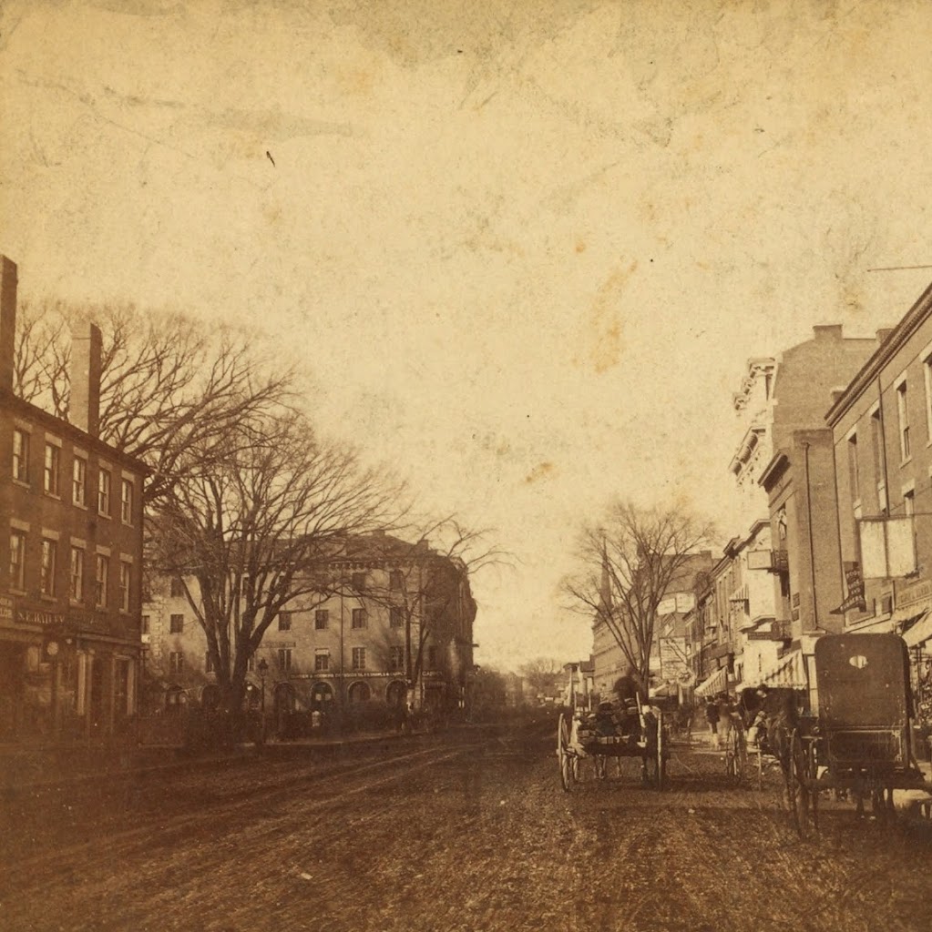
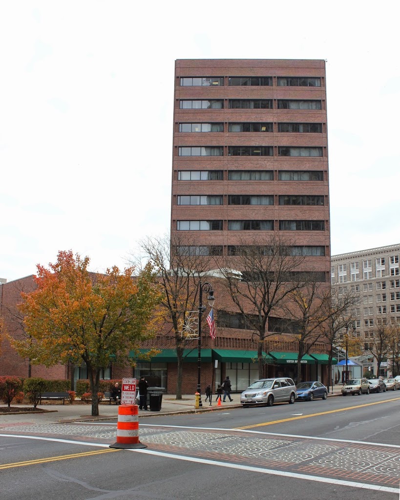
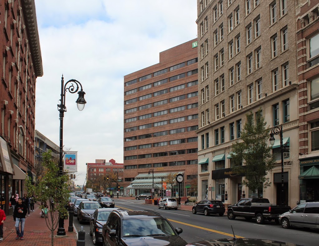
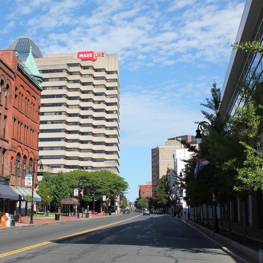
1870s

The scene in 2017:

The first photo has to be one of the earliest photographic views that I’ve seen of Main Street in Springfield.  Most of the views of Main Street that I have featured on this blog show a busy urban scene with large commercial buildings.  That wasn’t the case in this photo, which was probably taken right after the end of the Civil War.  There is certainly commercial activity going on in the foreground, in the immediate vicinity of Court Square, but further up Main Street it has not yet been developed to the extent that later photographs show, such as this one taken a block north and about 50 years later.

Many of the commercial buildings in this scene, especially the ones on the far left and far right, show the Federal style architecture that was common for commercial buildings in Springfield during the first half of the 19th century.  Most of these would be demolished by the turn of the century and replaced with larger, more modern buildings, such as the 1889 Chicopee Bank Building on the left-hand side in the 2017 photo.  Today, as far as I can tell, the only surviving examples are Byers Block just around the corner on Elm Street, Guenther & Handel’s Block on Stockbridge Street, and the Gunn and Hubbard Blocks on State Street opposite the Armory.

Almost everything from the first photo is gone today, including several blocks on the right-hand side, where the MassMutual Center was built in the 1970s.  However, there are at least two buildings from the first photo that still exist, in the block visible in the distance just in front of the church steeple.  This block was made up of three buildings, two of which survive today: the former Johnson’s Bookstore building and the Republican Block.  It is also possible that the 1865 Haynes Hotel (seen in this post) appears in the first photo, although from this angle it is hard to tell.

Corner of Main & Hillman Streets, Springfield, Mass

The southeast corner of Main and Hillman Streets in Springfield, around the 1870s or 1880s. Photo courtesy of the New York Public Library.

407_1865-1885c-2Bnypl

The scene in 2014:

407_2014

Nothing from the first photo still exists today; even the street network has changed.  The corner of Main and Hillman technically doesn’t exist anymore – Hillman Street now ends a block away from Main Street, and the rest is now a pedestrian walkway along one side of Center Square.  Further down the street, the church building is on the site of what is now the corner of Main and Harrison – this intersection was moved so that Harrison and present-day Boland Way were directly across from each other on Main Street.

There are a few notable buildings visible in the first photo, including the Third National Bank Building in the foreground.  This ornate building was the home of the bank, but the upper floors were the Evans House hotel, which was described in the 1884 King’s Handbook of Springfield as “the leading family hotel” and a “convenient, pleasant, and home-like hotel.” Today, neither the hotel, nor the bank, nor the building itself still exist, although the site is still used for banking, with TD Bank now occupying the site.

Further down the street in the first photo is First Baptist Church.  The congregation was established in 1811, and met in several different locations around the city before moving to the Main Street site and constructing the church building in 1847.  However, as the downtown area became more developed, property along Main Street became valuable commercial space, and in 1888 the church was sold and replaced by a commercial building, which can be seen in the center of this post, taken facing the opposite direction.

Corner of Main & Bridge Streets, Springfield, Mass

The northwest corner of Main and Bridge Streets in Springfield, sometime in the early 1880s. Photo courtesy of New York Public Library.

406_1865-1885c-2Bnypl

Main and Bridge in 1938-1939.  Image courtesy of the Springfield Preservation Trust.

406_1938-1939c spt

The same location in 2017:

The building in the first photo was the home of W.D. Kinsman’s store, which was described in the 1884 King’s Handbook of Springfield as a “fancy dry-goods and novelties establishment.”  According to the book, Warren D. Kinsman opened the business in 1866 and moved to the location at the corner of Main and Bridge Streets in 1880.  However, the engraving in King’s Handbook shows a building that is five bays wide on the Main Street facade, as opposed to the three which are seen in this photo.  This would seem to suggest a date of around 1880 for the first photo; the building must have been expanded to the right sometime soon after.  The Kinsman building was demolished by the 1930s, and Kresge’s 5 and 10 cent store was built on the site, as seen in the second photo.  Today, Kresge’s is also gone; it was replaced by the former Federal Building, which was renovated in 2009 and is now an office building.

Kibbe Brothers Candy, Springfield, Mass

Kibbe Brothers candy factory on Harrison Avenue in Springfield, in October 1910. Image courtesy of the Library of Congress, National Child Labor Committee Collection.

405_1910-10-2Bloc

The scene in 2014:

405_2014

I have previously featured a number of photos from Lewis Wickes Hine of the National Child Labor Committee, when he traveled around the country documenting child labor conditions in the early 1900s.  His work includes several Springfield companies, one of which was Kibbe Brothers Company, a candy company that had been in Springfield since 1843.

For many years, the company operated out of a building at the corner of Main and Harrison, but in 1890 they moved about a half a block down Harrison Ave, where this 1910 photo was taken.  This photo is rare among Hine’s photos in that it doesn’t feature any photos, but it does show the “Girls Wanted” and “Boys Wanted” signs in the window next to the main entrance.  Based on the other photos that Hine took of the factory workers, many of them were 14 to 15 years old, which was apparently the minimum working age at the time.  In some of the captions, he mentions that they made between $3.50 and $4.00 per week, which in 2014 dollars would be about $86 a week.

According to Springfield Present and Prospective (1905), the factory employed about 350 people and produced over 12 tons of candy each day, which was shipped as far as California.  However, the company was out of business by the mid-1930s, probably a victim of the Great Depression.  Today, part of the lot is occupied by the headquarters of Hampden Bank, and the rest of it is a parking lot and parking garage.

Main Street, Springfield, Mass

Looking north on Main Street in Springfield, toward Harrison Avenue, around 1910-1920. Image courtesy of the Library of Congress, Detroit Publishing Company Collection.

Springfield

The same location in 2014:

404_2014

These photos were taken facing the opposite direction of the ones in this post and this post, with the Haynes Hotel building on the far left and the Johnson’s Bookstore building on the far right.  These are the only two surviving buildings in the photo for several blocks down Main Street; everything on the right-hand side from Johnson’s Bookstore to the Fuller Block (the building in the distance with the onion dome in the first photo) at the corner of Bridge Street has been demolished.

Notice all of the trolleys in the first photo – and the pedestrians who seem to have no problem crossing right in front of them.  Today, there are no trolleys, far fewer pedestrians, and far more cars on this stretch of Main Street.

Nayasset Club, Springfield, Mass

The Nayasset Club on State Street in Springfield, opposite the Hampden County Courthouse, around 1910. Photo from View Book of Springfield, Massachusetts (1910).

Organizations

The same location in 2014:

403_2014

I previously mentioned the Nayasset Club in this post, where the club’s building can be seen on the right-hand side of State Street.  Here, the full building can be seen in the first photo, and it appears to have been completed right around the time when the photo was taken.  I don’t know what became of the club, but the building is now a parking lot, and soon this site will be developed as an MGM casino.