Lost New England Goes West: Sacramento Street, San Francisco (2)

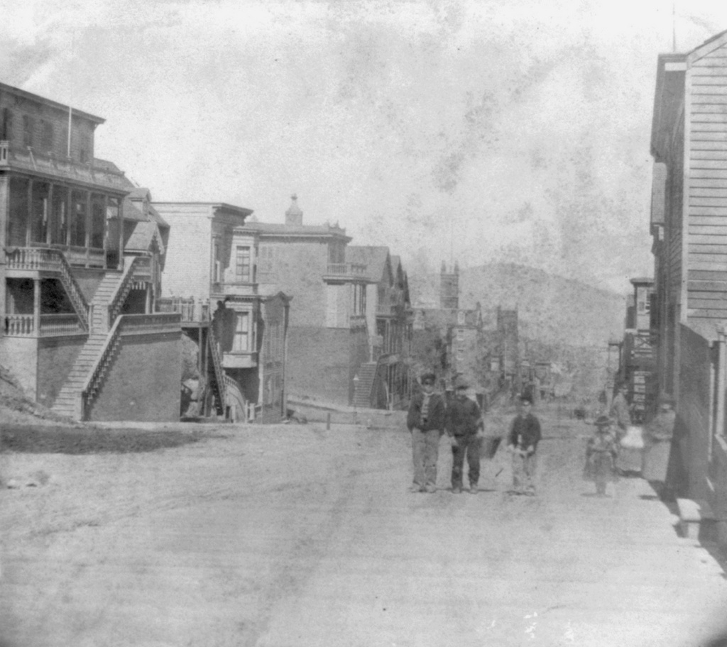
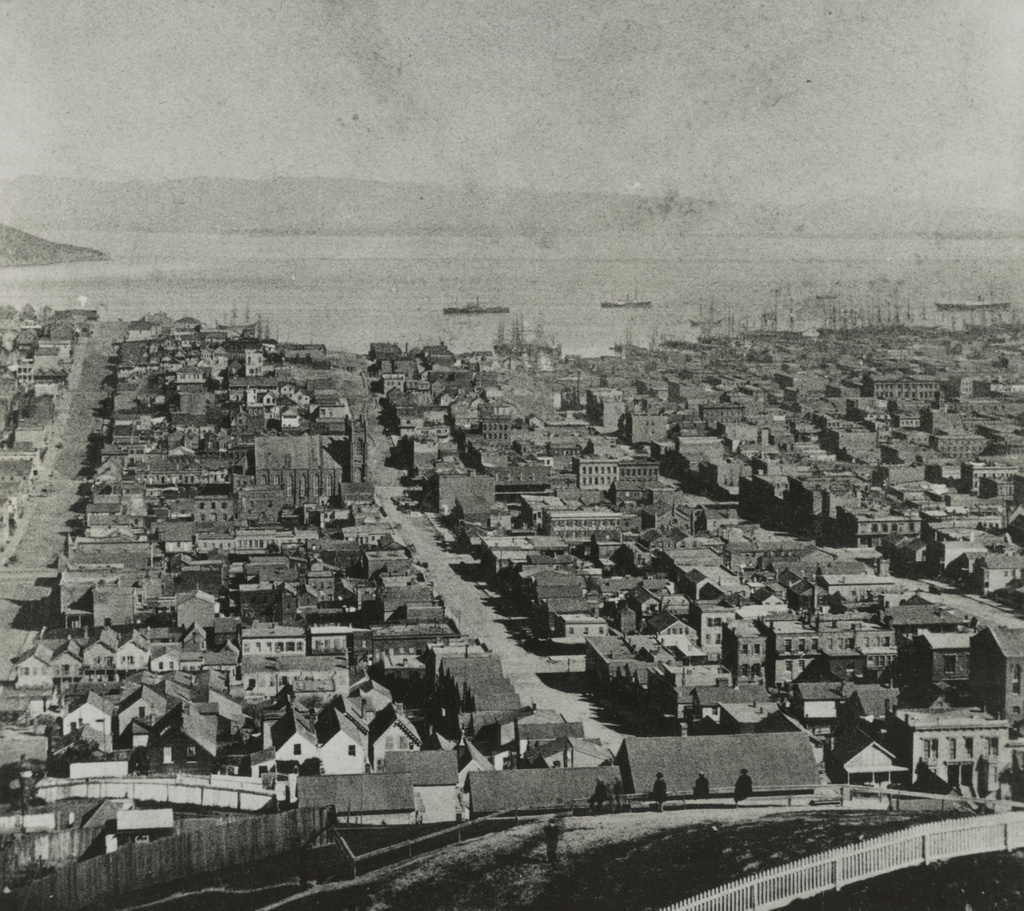
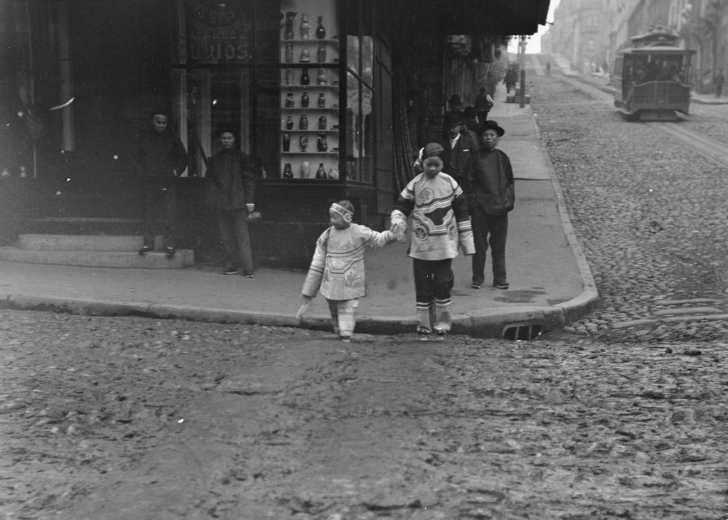
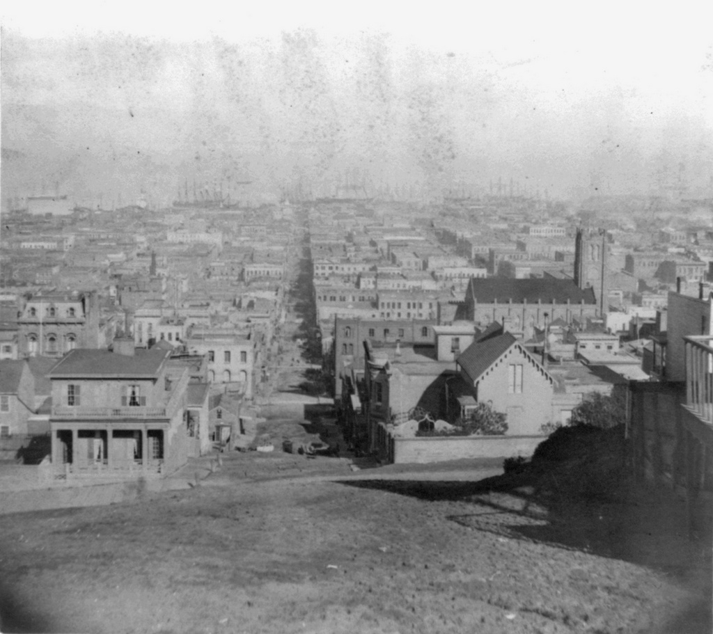
Looking down Sacramento Street from the corner of Powell Street in San Francisco, around 1866. Image courtesy of the Library of Congress, Lawrence & Houseworth Collection.

890_1866c loc

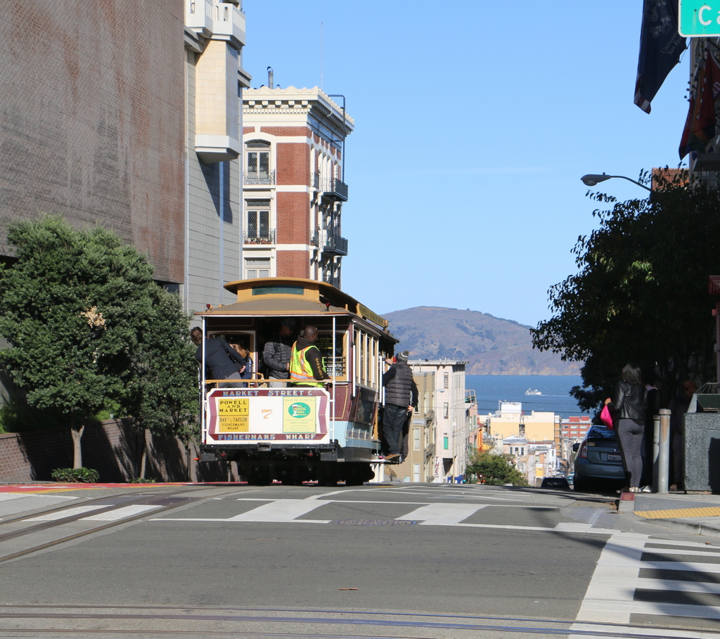
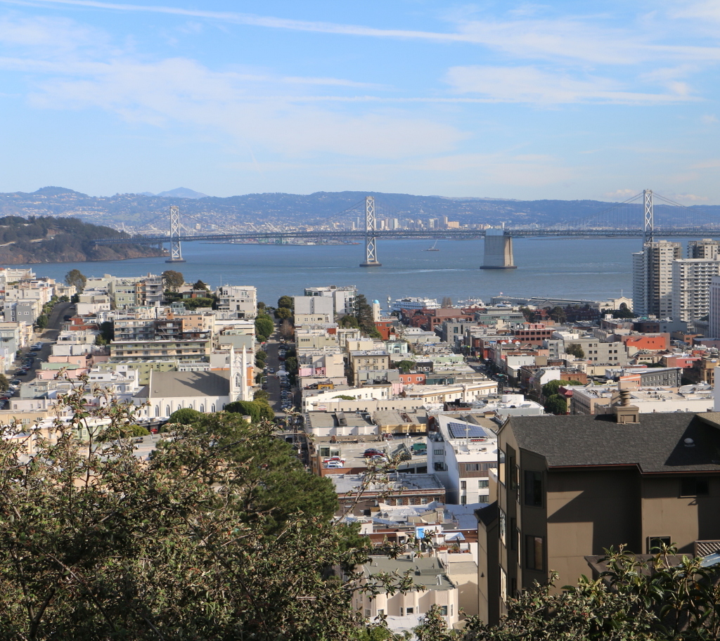
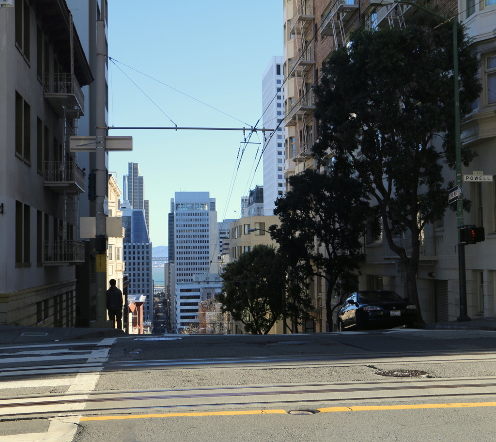
Sacramento Street in 2015:

890_2015
The first photo here was taken just a half block further up the hill from where, 40 years later, Arnold Genthe would take his famous photograph of the earthquake. Much of this view had changed by 1906, but many of the buildings from this 1866 view were still standing up until the fires destroyed this entire scene. One of the few buildings that survives today from the 1866 photo – in fact, it may be the only one left – is the church on the right side. This is the Old Saint Mary’s Cathedral, which was built in 1854 and, although gutted by the fires in 1906, was repaired and is still standing at the corner of California and Grant Streets.

The view of the church from here is now blocked by modern buildings, and the city’s skyline has obviously changed considerably in the 150 years since the first photo was taken. In the distance down Sacramento Street is the Financial District with its skyscrapers, and at the very end of the street, barely visible, is the Ferry Building, which was built over 30 years after the first photo was taken,. It was one of the few historic buildings still standing in this scene, and also one of the few that survived both the earthquake and the fires.

This post is part of a series of photos that I took in California this past winter. Click here to see the other posts in the “Lost New England Goes West” series.

Lost New England Goes West: Powell Street, San Francisco

Looking north on Powell Street from the corner of California Street in San Francisco, around 1866. Image courtesy of the Library of Congress, Lawrence & Houseworth Collection.

889_1866c loc

Powell Street in 2015:

889_2015
The image of a cable car descending a steep hill, with San Francisco and the bay visible in the distance, is what many people picture when they think of San Francisco, and although it wasn’t deliberate on my part, that is exactly what the present-day scene shows. However, the first photo shows a very different scene along Powell Street. At the time, San Francisco was still very much a “wild west” kind of city, and the Nob Hill area here had not yet developed into the wealthy neighborhood that it would soon become. The cable car system was also still several years away, so at the time the only way up the steep streets to Nob Hill was by horse or, as the young boys in the photo chose to do, by walking.

Any buildings from the first photo that would have still been standing 40 years later would have been destroyed in the 1906 earthquake, when fires spread across this entire area. Aside from the nearby Flood Mansion, all of the Victorian-era mansions on Nob Hill burned down, and the only other surviving building in the area was the Fairmont Hotel, located just to the left of this scene. However, like the rest of the city, the neighborhood was rebuilt, and today it remains one of the city’s most expensive areas, thanks to its commanding views and proximity to the center of San Francisco.

This post is part of a series of photos that I took in California this past winter. Click here to see the other posts in the “Lost New England Goes West” series.

Lost New England Goes West: View From Nob Hill, San Francisco

Facing northeast from the corner of California and Powell Streets in San Francisco, around 1866. Image courtesy of the Library of Congress, Lawrence & Houseworth Collection.

888_1866c loc

The view in 2015:

888_2015
Like the view in the previous post, these photos show San Francisco as it appeared in its early years. It had experienced rapid growth during the Gold Rush, and less than 20 years later in the 1860s it was becoming a major city and port on the west coast. The first photo shows the present-day Jackson Square, Portsmouth Square, and Financial District areas, with San Francisco Bay and Yerba Buena Island in the distance. There are a number of ships in the bay or at the wharves, which were likely arriving from or departing for ports around the world. At the time, the city was largely dependent on ships. The Transcontinental Railroad would not be completed for three more years, and the Panama Canal was still almost 50 years away, so the most economical trading route from San Francisco to New York and other east coast ports was the two month, 13,000 mile journey around the southern tip of South America.

Within a few years after the first photo was taken, San Francisco’s population reached 150,000, which was an astonishing 15,000% increase from just 20 years earlier. In the years that followed, the growth continued, and by the time the 1906 earthquake struck, the population was around 400,000. Many of the buildings in the first photo were likely still standing in 1906, but this entire area was destroyed by the fires that were started by the earthquake. At least one building in this view did survive, though. The Montgomery Block, visible just above and to the right of the center, was built in 1853 and stood at the corner of Montgomery and Washington Streets until 1959, when it was demolished and replaced with a parking lot.

Today, development in downtown San Francisco has completely blocked the view of the bay from here. The most prominent building in this view is the Transamerica Pyramid, which was completed in 1972 on the site of the Montgomery Block. It remains the city’s tallest building, and its pyramid shape is instantly recognizable in the San Francisco skyline.

This post is part of a series of photos that I took in California this past winter. Click here to see the other posts in the “Lost New England Goes West” series.

Lost New England Goes West: View From Russian Hill, San Francisco

The view looking east from the top of Russian Hill, looking down Vallejo Street and facing San Francisco Bay, around 1866. Image courtesy of the Library of Congress, Lawrence & Houseworth Collection.

887_1866c loc

The view in 2015:

887_2015
It was hard to get to the exact location of the original image, because most of Russian Hill is now covered in buildings. However, this view from the top of Vallejo Street just east of Jones Street was pretty close. The first photo was taken in the early years of San Francisco’s history, when the city was in the midst of a rapid population boom. By the mid-1860s, the initial Gold Rush was over, but the city continued its dramatic growth, increasing from about a thousand in 1848 to nearly sixty thousand in 1860. By 1870, the population was nearly triple that, and the section of the North Beach neighborhood seen here was completely developed.

The three streets in this view are, from left to right, Green Street, Vallejo Street, and Broadway Street. At the time, the area to the right of Broadway Street was part of the city’s infamous “Barbary Coast” – a red light district that attracted miners and sailors with drinking, gambling, prostitution, and entertainment. This continued until 40 years after the first photo was taken, when the entire area was destroyed by the 1906 earthquake and the fires that followed.

Today, the only identifiable building remaining from the first photo is the Saint Francis of Assisi Church, on the left side of Vallejo Street at the corner of Columbus Avenue. It was built in 1860, and although the fires in 1906 gutted the building, the brick walls and towers remained standing. The interior was rebuilt and rededicated in 1919, and today it is the National Shrine of Saint Francis of Assisi.

Remarkably, though, despite all of the changes to the neighborhood, the church still stands out as a major landmark. Unlike the nearby Financial District to the right, the development in this area is still largely two and three story buildings, so the view really doesn’t look dramatically different from 150 years ago. The one major change, of course, is the Bay Bridge in the distance, which was completed in 1936, connecting San Francisco to Yerba Buena Island on the left and Oakland on the other side of the bay.

This post is part of a series of photos that I took in California this past winter. Click here to see the other posts in the “Lost New England Goes West” series.

Lost New England Goes West: Chinatown, San Francisco (2)

The corner of Grant Avenue and Washington Street in San Francisco, around 1920-1930. Image courtesy of the Library of Congress, Arnold Genthe Collection.

886_1920-1930c loc

The view in 2015:

886_2015
While the Arnold Genthe photo in the previous post showed San Francisco’s Chinatown before the 1906 earthquake, this view a block away shows the neighborhood some 20 years after it was rebuilt. By this time, though, Chinatown was seeing the effects of many years of anti-Chinese immigration policies, such as the Chinese Exclusion Act of 1882, which made it almost impossible for Chinese women or families to immigrate to the United States. When the first photo was taken, the neighborhood’s population was at an all-time low, and this would not begin to rise again until after World War II, when the Exclusion Act was repealed due to American alliances with China during the war.

Today, it is the largest Chinese community in the world outside of Asia, and in the past 90 years or so this particular view has hardly changed. The building is still standing, as are the ones in the distance to the left, and even minor details such as the fire escapes and the lamppost are the same as they were in the 1920s. The influence of Chinese culture is still very apparent, and Grant Avenue in particular, as shown here, is a major tourist destination in San Francisco.

This post is part of a series of photos that I took in California this past winter. Click here to see the other posts in the “Lost New England Goes West” series.

Lost New England Goes West: Chinatown, San Francisco (1)

The corner of Jackson Street and Grant Avenue in San Francisco, around 1896-1906. Image courtesy of the Library of Congress, Arnold Genthe Collection.

885_1896-1906c loc

The scene in 2015:

885_2015
San Francisco’s Chinatown is the largest Chinese community in the world outside of Asia, and it was also America’s original Chinatown. Immigrants from China arrived here around the same time that almost everyone else did, during the Gold Rush of the late 1840s and early 1850s. Later on, many other Chinese people came to find work on projects such as the Transcontinental Railroad, and this neighborhood became an ethnic enclave within the city.

Photographer Arnold Genthe was primarily known for his portrait work, and his clients included many notable politicians, writers, and entertainers. In addition, he photographed the immediate aftermath of the 1906 earthquake, including the one in the previous post, but his works also included hundreds of photos of Chinatown that were taken beginning in the 1890s. His collection, which includes the first photo here, provides the only real glimpse into everyday life in Chinatown before the earthquake.

This scene, along with the rest of Chinatown, was completely destroyed in the earthquake, and some politicians sought to use the disaster to rebuild Chinatown further from the center of the city. However, the plans ultimately failed, and Chinatown was rebuilt here, where it continues to be a vibrant community as well as a popular tourist destination in the city.

This post is part of a series of photos that I took in California this past winter. Click here to see the other posts in the “Lost New England Goes West” series.