John Banister House, Newport, Rhode Island

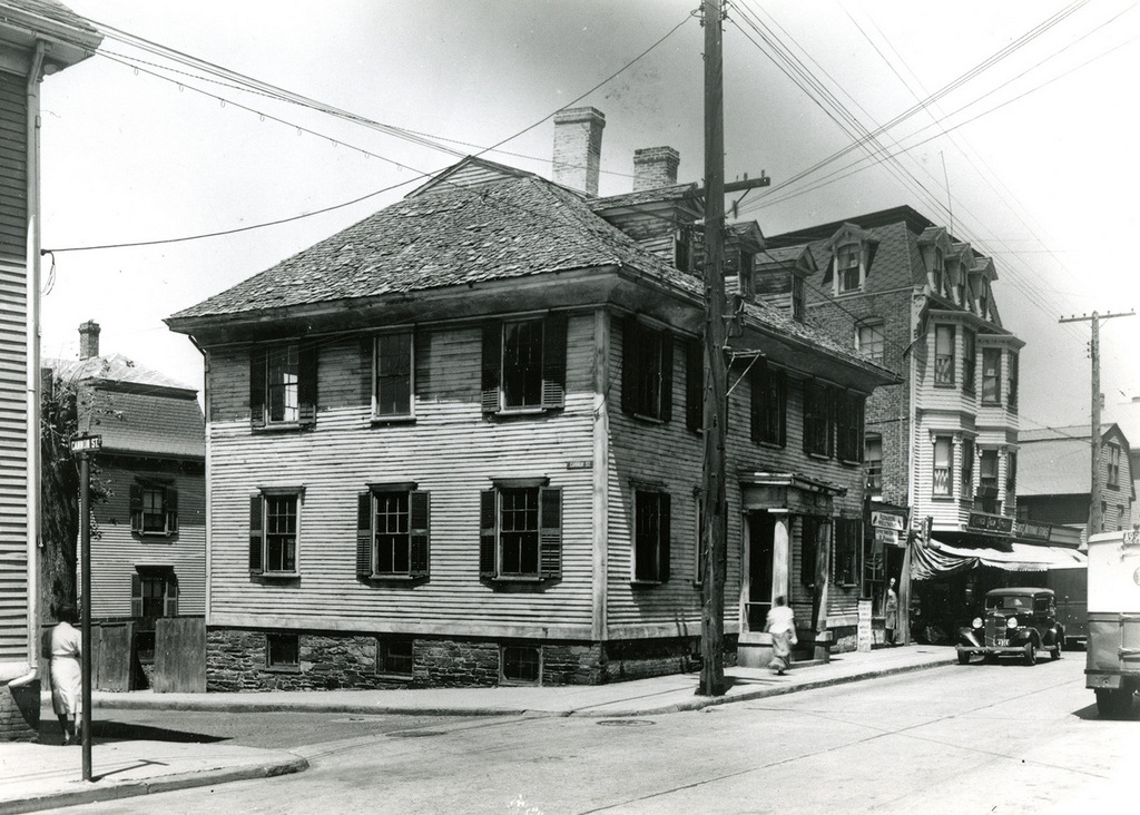
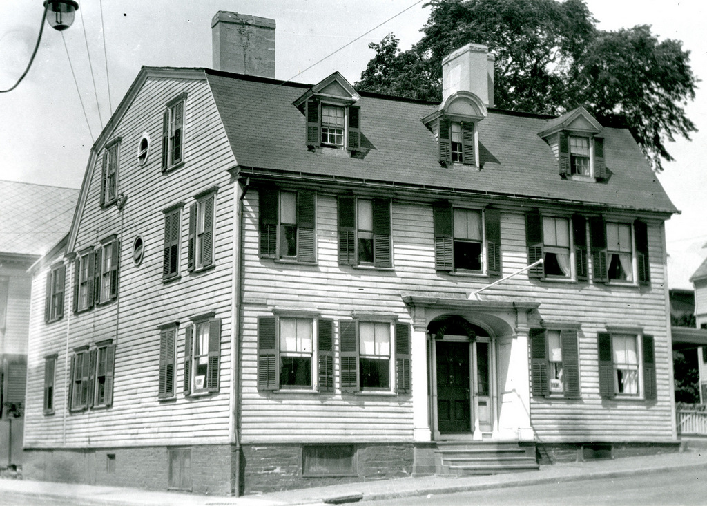
The house at 56 Pelham Street, at the corner of Spring Street in Newport, around 1930. Image courtesy of the Providence Public Library.
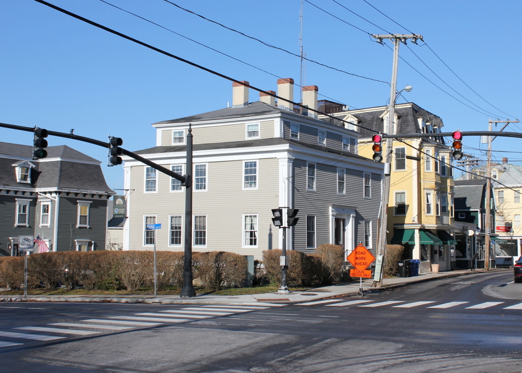
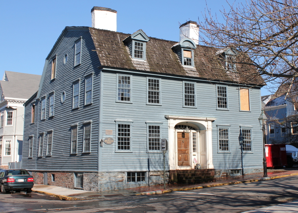
The house in 2017:

This large, elegant Georgian-style home was built in the early 1750s, and was built as the home of John Banister (1707-1767), a prosperous colonial merchant. Banister was originally from Boston, but subsequently came to Newport, where he married Hermione Pelham in 1737. She came from one of Newport’s leading families, and her great-grandfather, Benedict Arnold (1615-1678), had served for many years as the colonial governor of Rhode Island. Governor Arnold, whose other descendants included the Revolutionary War traitor of the same name, owned a significant amount of land in downtown Newport, including the Newport Tower, which still stands a few blocks away from here. This property was later inherited by the Pelham family, and then by John Banister after the death of his father-in-law in 1741.

Banister built this house on the property about a decade later. He and Hermione had two sons, John and Thomas, who grew up here, and John inherited the house after his father’s death in 1767. However, the two brothers later found themselves on opposite sides of the American Revolution. Thomas was a loyalist, and even enlisted in the British army during the occupation of Newport, while John supported American independence. In retaliation for his patriot views, the occupying British forces seized this house, along with John’s farm in nearby Middletown. The house became the headquarters of General Richard Prescott during the occupation, although John later reclaimed his property following the British evacuation of Newport in 1779. His brother Thomas was less fortunate, though. As a loyalist, his property was confiscated by colonial authorities, and he never returned to Newport after the army’s evacuation.

By the time the first photo was taken around 1930, the house was nearly 200 years old, and was already recognized for its historical significance. Then, in 1968, it became a contributing property in the Newport Historic District, a National Historic Landmark district that encompasses much of the downtown area. Over the years, the interior has been heavily modified, but the exterior has remained largely the same as it was when the house was built. Even these two photos, taken nearly 80 years apart, do not show much of a difference, aside from the removal of the shutters. However, in recent years the John Banister House has fallen into disrepair, as shown by several boarded-up windows in the 2017 photo. Shortly after this photo was taken, though, work began on a major renovation of both the interior and exterior, including restoring the original floor plan, replacing the shingles and windows, and repairing damage to the chimneys, foundation, and frame. When this work is completed, the house will again be used as a single-family home.

For more information on the Banister House and its ongoing restoration, see these articles here and here on the Newport This Week website.

Pelham Street, Newport, Rhode Island

Looking east on Pelham Street, toward the corner of Spring Street in Newport, around the early 1880s. Image courtesy of the Providence Public Library.

The scene in 2017:

These photos show the same scene as those in an earlier post, just from the opposite view along Pelham Street. Here, a mix of 18th and 19th century homes line either side of the narrow street, with the United Congregational Church standing in the distance at the corner of Spring Street. Probably the oldest of these is the Langley-King House, which is partially visible on the extreme left of the photo. It was built around 1710, expanded around the mid-18th century, and eventually restored in the early 1970s. Next to it is the three-story John Gidley House, which was built around 1744, and further in the distance are several other homes that date to around the 18th century.

On the right side of the street, probably the newest house in the first photo is the Anthony Stewart, Jr. House. It was built around the 1860s or early 1870s, and its Victorian-era Mansard roof and bay windows stand in sharp contrast to the colonial-era buildings all around it. Its neighbor to the right, the c.1804 Jonathan Bowen House, also features a Mansard roof, although this was evidently added at some point after the first photo was taken. Further in the distance on the right is the small gambrel-roofed Lucina Langley House, which was built sometime before 1771 and still stands at 43 Pelham Street. However, its neighbor to the left, at the corner of Spring Street, was demolished sometime soon after the first photo was taken, and was replaced by the present-day William M. Austin House in 1883.

Perhaps the most historically significant building in this scene is the United Congregational Church. This Romanesque Revival-style brownstone church was completed in 1857, and was the work of noted New York architect Joseph C. Wells. At the time, the interior was largely plain, in keeping with the Puritan traditions of the Congregational Church, but this changed in 1880, when the prominent artist John La Farge was commissioned to redesign the interior. His only restriction was that he could not include illustrations of figures, or any Christian symbols, as these could be seen as violations of the second commandment’s prohibition of graven images. As a result, La Farge drew heavily upon Byzantine and even Islamic tradition, incorporating intricate geometric patterns and other abstract designs into his work. This ultimately included 20 stained glass windows, along with a number of murals on the walls and ceiling, and it was completed shortly before the first photo was taken.

Today, more than 130 years after the first photo was taken, remarkably little has changed in this scene. All of the houses are still here, except for the one on the right at the corner of Spring Street, and the church is also still standing. It is now partially hidden by trees and by the Austin House, but the only significant change is the loss of the pyramidal roofs atop the towers, which were destroyed in the 1938 hurricane and were never replaced. All of the buildings in this scene are now part of the Newport Historic District, a National Historic Landmark district that was created in 1968. However, the United Congregational Church was also individually designated as a National Historic Landmark in 2012, in recognition of La Farge’s interior design of the building.

Trinity Church, Newport, Rhode Island

Trinity Church, seen looking east along Frank Street in Newport, around 1901. Image courtesy of the Providence Public Library.

The scene in 2017:

Newport features an impressive collection of colonial-era buildings that have survived to the present day, but one of the most significant of these is Trinity Church, which is seen in these two photos. It was built in 1725-1726 as an Anglican church, replacing an earlier building that the congregation had previously used, and it was the work of local architect and builder Richard Munday. His design was based on the churches of London architect Christopher Wren, and it also bears a strong resemblance to Old North Church, which had been built just a few years earlier.

Although the building itself was completed in 1726, the spire was not added until 1741, and it had to be rebuilt in 1768. Another change came in 1762, when the church was expanded by 30 feet. In order to do this, the building was divided in half, the rear section was moved back, and the addition was built in the middle of the two halves. However, it has seen few significant changes since then, and it remains remarkably well-preserved, both on the exterior and interior.

Unlike in most other New England towns, Newport’s colonial-era churches were not built at the head of large public squares. This was an effect of Rhode Island’s legacy of religious tolerance, in order to avoid showing preference to one denomination over another. Because of this, houses of worship tended to have less prominent locations. Here, Trinity Church was situated on a narrow lot bounded by Spring, Church, and Frank Streets. The church building itself filled up most of the lot, with just enough room for a small churchyard on the north and west sides. As the first photo shows, this left the church crowded on all sides, and nearly hidden from view by an assortment of modest houses and commercial buildings.

This situation continued for much of the 20th century. However, a fire in 1973 destroyed the building at the corner of Thames and Frank Streets. This loss helped to spur the redevelopment of the entire block, and during the 1970s the Newport Restoration Foundation acquired properties in the two-block area between Mill and Church Streets. This project was led by the Newport Restoration Foundation’s founder, the tobacco heiress Doris Duke, and it eventually involved the removal of all the buildings here on Frank Street. These buildings held little historical or architectural value, and they were replaced by Queen Anne Square, a public park that stretches from the front of Trinity Church down to Thames Street.

Today, the narrow, cobblestoned Frank Street is still there, although the western end of it is now a pedestrian walkway through Queen Anne Park. With the street no longer cluttered with buildings, Trinity Church is now easily visible from Thames Street and the waterfront area, and it stands as the only surviving structure from the first photo. The nearly 300 year old church is now one a contributing property in the Newport Historic District, a National Historic Landmark district that encompasses much of downtown Newport. However, it is also individually listed as a National Historic Landmark, making it one of 18 buildings in Newport to be recognized as such.

Spring and Cannon Streets, Newport, Rhode Island

The northwest corner of Spring and Cannon Streets in Newport, around 1925. Image courtesy of the Providence Public Library.

The scene in 2017:

The first photo shows a somewhat dilapidated building that stood at the corner of Spring and Cannon Streets. It was probably built sometime in the late 18th or early 19th centuries, and by the time the first photo was taken it was a two-family home. The 1920 census, which had been done a few years later, shows Danish immigrant Andrew Christensen living in one unit with his wife Katherine and their three children. The other unit was rented by French-Canadian immigrant Hector Renaud, his wife Louise, and their daughter Alice. Both men were employed by the navy, with Christensen serving as a chief boatswain’s mate in the navy, and Renaud as a machinist at the U. S. Naval Torpedo Station.

By the time the first photo was taken around 1925, the house appears to have been in poor condition, particularly the roof. It was evidently still occupied, though, because the city directories of the mid-1920s continue to list tenants here. By the 1930 census, it was rented by two more immigrant families, with Italian-born shoe repairer Pasquale Panaggio in one unit with his wife Sarah and four children, and Irish-born gardener Florence C. Sullivan in the other one with his wife Mary and two children.

Today, the old house from the first photo is no longer standing, and was presumably demolished at some point in the mid-20th century. However, there is a different historic building that is still standing on the site. The Newport Historic District building inventory lists it as the Jeremiah J. Sullivan House, with an estimated construction date of 1836-1839. Since this is clearly not the same building that was standing here when the first photo was taken, it must have been moved to this site at some point after the other building was demolished.

The streets have also changed since the first photo was taken. Cannon Street, once a narrow one-block street between Thames and Spring Streets, was significantly expanded in the mid-20th century, becoming part of Memorial Boulevard West. All of the buildings on the south side of the street were either moved or demolished, but the ones on the north side were largely unaffected. As a result, the other buildings from the first photo are still standing today, including the c.1894-1907 J. P. Ancaster House on the left, the c.1859-1876 Patrick Tiernan Building to the right, and the c.1758-1772 James Pitman House further to the right. All three buildings, along with the Sullivan House, are contributing properties in the Newport Historic District, which was designated as a National Historic Landmark in 1968.

Thames Street from Cannon Street, Newport, Rhode Island

Looking east on Cannon Street from the corner of Thames Street in Newport, around 1915. Image courtesy of the Providence Public Library.

The scene in 2017:

The first photo shows the view looking up the hill along Cannon Street, a narrow side street that stretched one block from Thames Street to Spring Street. At the time, the street was lined with a variety of houses, most of which appear to have been built during the 19th century. On the left side, at the corner of Thames Street, was a bicycle shop, and several bicycles are visible in the window, just above the dog on the sidewalk. Aside from the bicycles, the cars in the distance are the only other sign of modernity, as the rest of this scene had probably not undergone any significant changes in several decades.

However, this scene would change dramatically within only a year or two after the first photo was taken. Around 1916, the buildings in the foreground were demolished to build a new post office, which now stands on the left side of the present-day photo. Further changes came in the mid-20th century, when Cannon Street was significantly widened to become Memorial Boulevard West. All of the buildings on the south side of the street were either demolished or relocated, but the few remaining ones here on the north side were largely unaffected, aside from being renumbered with Memorial Boulevard West addresses.

Today, the only surviving building that is easily recognizable from the first photo is the yellow Victorian-style house just to the right of the center in the 2017 photo. According to the Newport Historic District inventory, it was built around 1850. However, it must have been significantly altered later in the 19th century, because its Mansard roof and small turret are more in line with architectural styles of the 1870s and 1880s. The house is hard to see in the first photo, but it is partially visible just behind the first car. At the time, it was the home of Mary Maloney, an Irish immigrant who worked as a laundress and lived here with her sister, her niece, and her nephew. The house has since been converted into a bed and breakfast, and it is now the Burbank Rose Inn.

Perry Mill, Newport, Rhode Island (2)

The Perry Mill, looking north along Thames Street from the corner of Fair Street in Newport, around 1902. Image courtesy of the Providence Public Library.

The scene in 2017:

As discussed in the previous post, the Perry Mill was built in 1835, on Thames Street in the southern part of downtown Newport. It was originally a textile mill, and was one of several such mills built during this period, in an effort to revive the city’s struggling economy. Newport’s shipping business had fallen on hard times since the American Revolution, and the Perry Mill was an attempt to compete with New England’s rapidly-growing industrial cities. However, Newport’s location on an island in the middle of Narragansett Bay proved a barrier to railroad transportation, and its fledgling manufacturing base never achieved the prominence of nearby mainland cities such as Providence and Fall River.

Despite this, Newport’s economy did ultimately recover, largely through becoming a Gilded Age summer resort community. By the time the first photo was taken at the turn of the 20th century, some of the wealthiest families in the country had summer homes here in Newport, although most of these were to the south of the downtown area. This section of Thames Street remained decidedly working-class, as shown by the businesses here, which included a coal dealer on the left, a flour and grain dealer on the ground floor of the Perry Mill, and a grocer in the building just beyond the mill.

Today, much of this scene has changed, particularly the buildings just beyond the Perry Mill, which were demolished in the mid-20th century to build America’s Cup Avenue. The mill building itself also underwent some changes, with the removal of the gabled roof and fourth floor. For many years, the property was owned by General Electric, but it was subsequently converted into retail use, and the upper part of the building was reconstructed. The brick section on the left side is also a 20th century addition, but otherwise the only noticeable sign of change is the slightly different shade of stone between the three lower floors and the fourth floor.