Front Steps, First Presbyterian Church, Holyoke, Mass

A group of children sitting on the front steps of the First Presbyterian Church, at 237 Chestnut Street in Holyoke, around 1892. Image from Picturesque Hampden (1892).

The scene in 2017:

As discussed in the previous post, the First Presbyterian Church of Holyoke was established in 1886, and moved into this newly-completed Romanesque Revival-style building two years later. It was built of contrasting granite and brownstone blocks, and had two front entrances on the Chestnut Street side. This particular scene shows the northwestern entrance, which is on the right side of the building when facing it from the street, and it provides good detail of the rough-faced blocks that make up the exterior of the building.

The first photo was taken only a few years after the church was completed, and shows a group of five young children sitting on the front steps. Although the children are unidentified, their parents likely worked in some of the many factories in Holyoke, and they themselves probably ended up working in the factories too. Some may have even attended this church for the rest of their lives, since the building was owned by the First Presbyterian Church for more than a century after the photo was taken.

Today, around 125 years later, not much has changed in this scene. The church is still standing, and this entrance has seen only minor changes, such as a new door and the addition of railings on the steps. The building is a good example of Romanesque Revival architecture, and it is one of many historic 19th century churches in Holyoke. Although the original congregation sold it in 2002, is still in use as a church, and is now the home of the Centro de Restauracion Emanuel.

First Presbyterian Church, Holyoke, Mass

The First Presbyterian Church, at 237 Chestnut Street in Holyoke, around 1892. Image from Picturesque Hampden (1892).

The church in 2017:

The First Presbyterian Church of Holyoke was established in 1886, with an initial membership of 77 people. James M. Craig was ordained as the first pastor, and the congregation worshipped in several different locations over the next two years. However, the church soon outgrew its temporary quarters, and in 1887 it acquired this property, at the corner of Chestnut and Cabot Streets. Construction of the church building began in September, and the first services were held here less than a year later, in August 1888. It was formally dedicated on March 5, 1889, in a ceremony that included a sermon by the Reverend John Hall, the prominent pastor of the Fifth Avenue Presbyterian Church in New York City.

Contemporary descriptions of the church do not mention an architect, but it features a Romanesque Revival-style design, which was popular for churches of this period. The exterior was built primarily of granite, but it also included contrasting brownstone trim that gave it a polychromatic appearance. The Chestnut Street facade, which is seen here in this view, was almost symmetrical, except for the different-sized turrets on the corners. Like most other Romanesque churches, it also incorporates rounded arches, stained glass, and tall, narrow windows into its design.

The congregation continued to grow over the next few decades, and by the early 20th century it had over 700 members. They would worship here throughout the rest of the century, although during this time the exterior of building was altered, including the removal of the upper part of the roof, and the shortening of the turret on the right side. Overall, though, the building survives as a good example of Romanesque Revival-style architecture, and it is one of many historic late 19th century church buildings that still stand in Holyoke. However, it no longer houses its original Presbyterian congregation. The property was sold in 2002, and it is now occupied by the Centro de Restauracion Emanuel.

High Street from Hampden Street, Holyoke, Mass

Looking south on High Street from the corner of Hampden Street in Holyoke, around 1892. Image from Picturesque Hampden (1892).

The scene in 2017:

Much of High Street in Holyoke has been remarkably well-preserved over the years, particularly this block on the west side of the street, between Hampden and Dwight Streets. It consists primarily of brick, three and four-story commercial blocks that were built in the second half of the 19th century, during the early years of Holyoke’s development as a major industrial center. The scene had largely taken on its present-day appearance by the time the first photo was taken in the early 1890s, and today the only significant difference is a noticeable lack of horse-drawn carriages.

According to district’s National Register of Historic Places listing, the one-story building in the foreground was built in the mid-20th century, but it seems possible that it might actually be the same one from the first photo, just with some major alterations. Either way, this is the only noticeable change in the buildings on this block. Just beyond this building are two matching three-story buildings, located at 169-175 High Street. These are perhaps the oldest buildings in the scene, dating back to around 1855, and have a fairly plain exterior design, unlike the more ornate building further down the street.

To the left of these two buildings is the four-story Dougherty’s Block, at 177-179 High Street. This was built sometime around the late 1880s, and was probably the newest building in the first photo. Beyond it is the 1870 Taber Building, with its distinctive ornate pediment above the third floor. However, the most architecturally-significant building in this scene is the Second Empire-style Caledonia Building at 185-193 High Street. It was built in 1874, and was originally owned by Roswell P. Crafts, a businessman who went on to become mayor of Holyoke in 1877 and from 1882 to 1883. The building was later owned by the Caledonian Benefit Society, which provided aid for Scottish immigrants.

Beyond the Caledonia Building, most of the other buildings also date to between 1850 and 1880. These include, just to the left of the Caledonia Building, the Johnson Building at 195 High Street and the R.B. Johnson Block at 197-201 High Street, both of which date back to around the 1870s. Further in the distance is the 1850 Colby-Carter Block at 203-209 High Street, and the c.1870 Ball Building at 211-215 High Street. The only noticeable change in this section is the six-story Ball Block, at the corner of Dwight Street. It was completed in 1898, a few years after the first photo was taken, and is visible on the far left side of the 2017 photo.

More than 125 years after the first photo was taken, this section of High Street survives as a good example of Victorian-era commercial buildings, representing a range of architectural styles from the plain brick buildings of the 1850s, to the more ornate styles of the 1870s and 1880s. Holyoke is no longer the thriving industrial city from the first photo, having experienced many years of economic stagnation since the mid-20th century. However, this has probably contributed to the survival of so many 19th century buildings, since there has been little demand for new construction, and today these historic buildings and streetscapes are among the city’s greatest assets.

School of the Immaculate Conception of Notre Dame, Holyoke, Mass

The former School of the Immaculate Conception of Notre Dame, on Chestnut Street opposite Hampden Park in Holyoke, around 1892. Image from Picturesque Hampden (1892).

The scene in 2017:

Holyoke grew into a major industrial center during the second half of the 19th century, and the jobs in the mills attracted large numbers of immigrants, particularly the Irish and French Canadians. Most of these immigrants were Catholic, in a region that had previously been almost entirely Protestant, and they soon set about establishing Catholic churches and other religious institutions. The first of these churches was St. Jerome’s, which was established in 1856. Two years later, the parish constructed a church building that still stands at the corner of Hampden and Chestnut Streets, just out of view to the right of this scene.

In 1869, St. Jerome’s Parish opened its first parochial school, the School of the Immaculate Conception of Notre Dame. It was originally an all-girls school, and was located in a wood-frame building that was moved to this site. That same year, the Convent of Notre Dame was completed just to the right of the school. It housed the nuns who taught at the school, and can be seen in the center-right of both photos, with its central tower and Second-Empire style architecture. Then, in 1872, the St. Jerome’s Institute was established as a school for boys, and was located on the other side of Hampden Street, at the corner of Elm Street.

The original Immaculate Conception building was replaced in 1883 by a much more substantial brick school building, which stands on the left side of both photos. It was designed by architect Donat R. Baribault, with an Italianate-style design that included a symmetrical front facade and a tower above the main entrance. By 1890, around the time that the first photo was taken, it had an enrollment of about 550 girls, and the principal of the school was also the sister superior at the adjacent Convent of Notre Dame.

The Immaculate Conception School later became the St. Jerome High School, and in 1963 it merged with several other parish high schools in the city to form Holyoke Catholic High School. The old 1883 school building became part of the Holyoke Catholic campus, and remained in use until 2002, when the school relocated to Granby. Holyoke Catholic has since merged with Cathedral High School in Springfield, and the consolidated school has been known as Pope Francis High School since 2016.

Today, most of the historic 19th buildings from the St. Jerome’s Parish are still standing, including the former Holyoke Catholic buildings. Although they were boarded up for more than a decade after the school moved to Granby, the buildings have since been converted into the Chestnut Park Apartments. This work was completed in 2015, and now there is hardly any difference between these two photos, which were taken 125 years apart. The buildings are now part of the Hampden Park Historic District, which was added to the National Register of Historic Places in 2012.

Canal Street, Holyoke, Mass

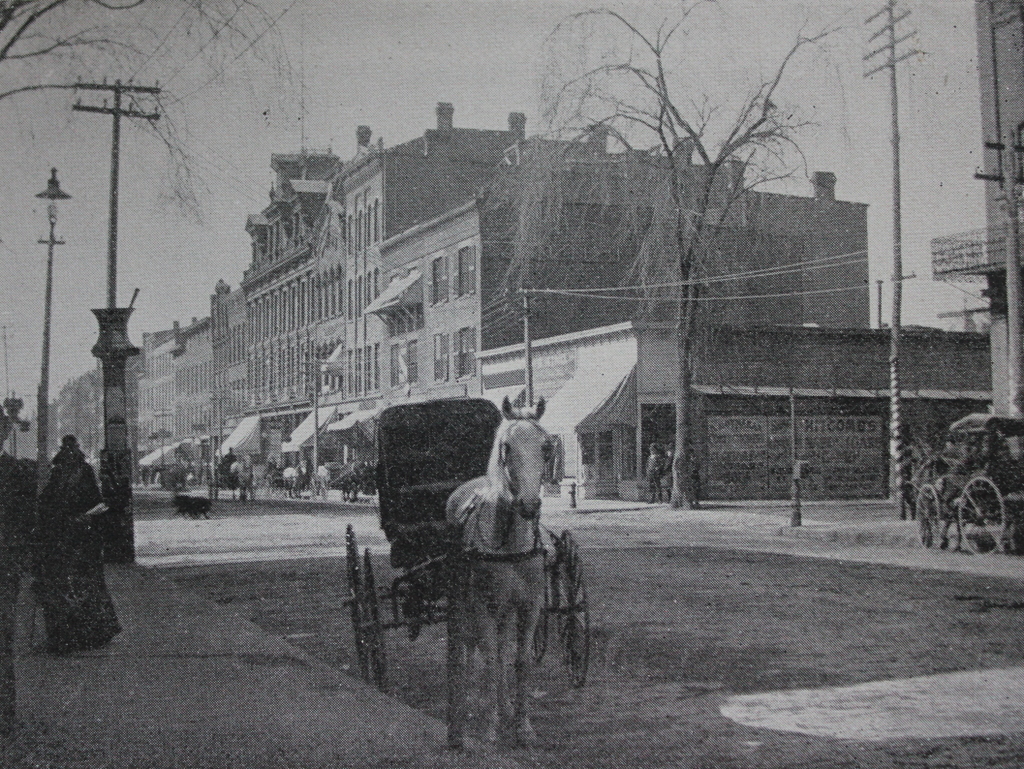
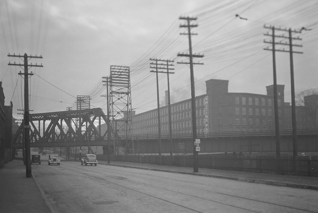
Looking southwest on Canal Street, toward the corner of Lyman Street in Holyoke, in 1936. Image taken by Lewis Hine, courtesy of the U. S. National Archives.
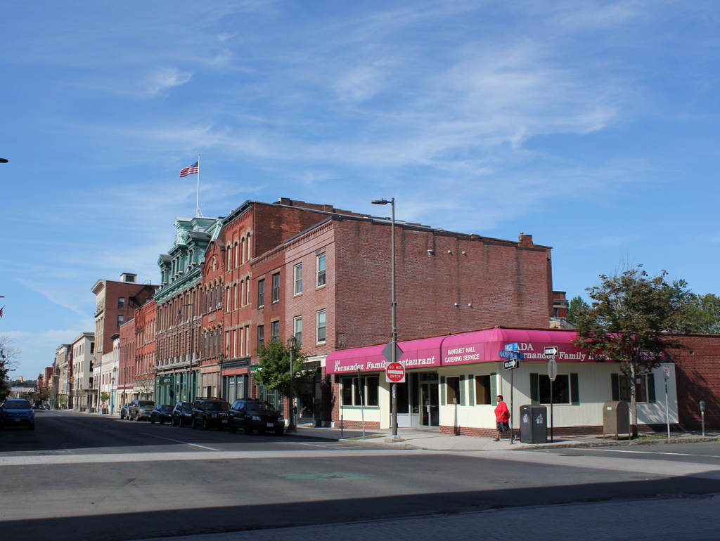
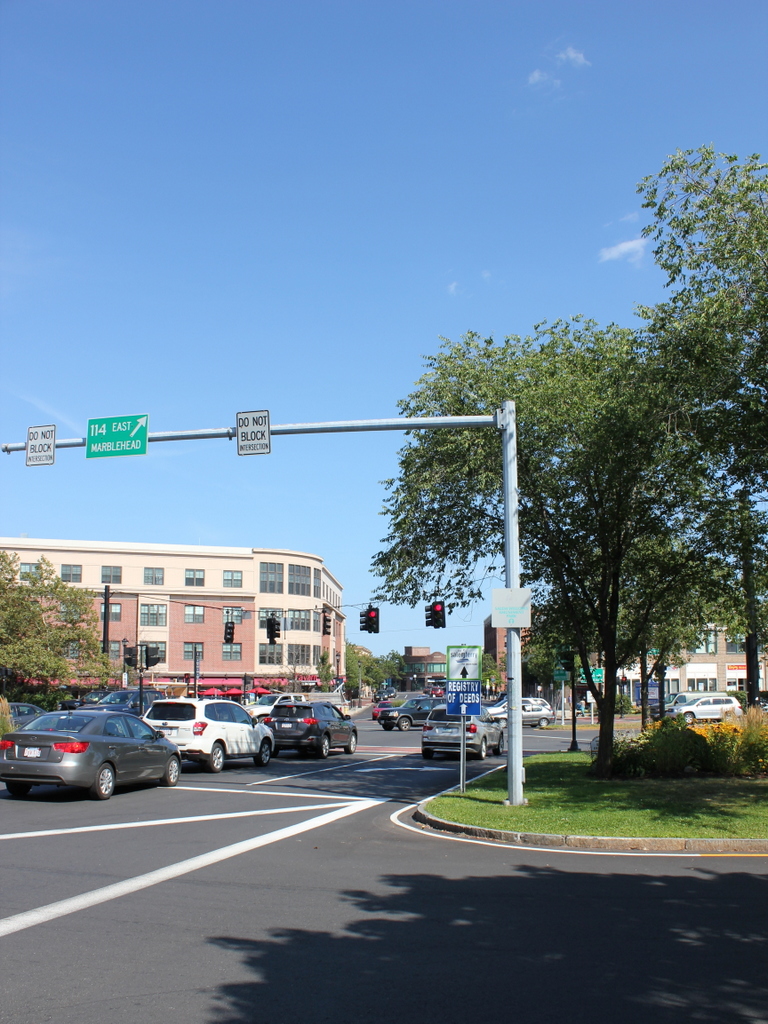
The scene in 2017:

The first photo was taken by the prominent photographer and social reformer Lewis Hine, who is best known for his early 20th century work with the National Child Labor Committee. However, later in life he also documented life across the country during the Great Depression, including a visit to Holyoke in 1936. At the time, the city was a leading producer of paper and textiles, and most of his photos focus on Holyoke’s industry. This photo shows the scene along Canal Street, with the Second Level Canal on the right. The Boston and Maine Railroad crosses through the middle of the photo, and in the background is the Whiting Paper Company, which was located in a building that had previously been occupied by the Lyman Mills. Hine’s original caption provides a short description of the photo:

Mt. Holyoke [sic]Massachusetts – Scenes. An old mill of absentee ownership, liquidated and sold at a great bargain to a new owner, who would not sell or rent, uses only a small part; railway transportation; electric power transmission. Lyman Mills (Now Whiting Company), 1936

The Lyman Mills company was incorporated in 1854, in the early years of Holyoke’s industrial development. It was located in the area between the First and Second Level Canals, on the south side of Lyman Street, and over the years its facility grew to include a number of mill buildings. The earliest of these, not visible from this angle, were built in 1849-1850, and were originally used by the Hadley Falls Company before being acquired by Lyman Mills. Other buildings, including the large one in the distance on the right side of the scene, were added later in the 19th century, and the company became a major producer of textiles. It also employed a significant number Holyoke residents, including many of the city’s French Canadian immigrants, and by the turn of the century it had a workforce of over 1,300 people.

However, as Hine’s caption indicates, the Lyman Mills corporation was liquidated in 1927. Although still profitable despite increased competition from southern manufacturers, the shareholders were evidently more interested in selling the company’s assets instead of continuing to operate it as a textile mill. Over a thousand employees were put out of work on the eve of the Great Depression, and the property was sold to the Whiting Paper Company, whose original mill was located directly adjacent to the Lyman Mills complex.

Founded in 1865 by William Whiting, this company went on to become one of the largest paper manufacturers in the country, and Whiting enjoyed a successful political career as mayor of Holyoke and as a U. S. Congressman. After his death in 1911, his son, William F. Whiting, took over the company and oversaw the expansion into the former Lyman Mills buildings in the late 1920s. The younger Whiting was a longtime friend of Calvin Coolidge, and in August 1928 Coolidge appointed him as the U. S. Secretary of Commerce, replacing Herbert Hoover, who would be elected president a few months later. Whiting served in this role for the remainder of Coolidge’s presidency, until Hoover’s inauguration on March 4, 1929.

The conversion of the Lyman Mills into paper production, along with Whiting’s brief tenure as Secretary of Commerce, occurred just a short time before the stock market crash of October 1929. By the time the first photo was taken seven years later, the country was still in the midst of the Great Depression. Like the rest of the country, Holyoke was hit hard by the Depression, but the Whiting Paper Company managed to survive and remain in business for several more decades. However, Holyoke continued to see economic decline throughout the mid-20th century, with most of its major manufacturers closing or relocating, and the Whiting Paper Company finally closed in 1967, just over a century after it had been established.

Today, however, this scene has hardly changed in more than 80 years since Lewis Hine took the first photo. Although no longer used to produce textiles or paper, the Lyman/Whiting complex is still standing in the distance, and has been converted into a mixed-use property known as Open Square. Closer to the foreground, the same railroad bridges still carry the tracks over Canal Street and the Second Level Canal, and even the transmission towers are still standing, although they do not carry any electrical wires anymore.

Railroad Station, Salem, Mass

The railroad station at the corner of Washington and Norman Streets in Salem, around 1910. Image courtesy of the Library of Congress, Detroit Publishing Company Collection.

The scene in 2017:

Salem was a prosperous seaport throughout the 18th and early 19th centuries, with a fleet of sailing ships that brought goods to the city from around the world. Given its location on the north shore of Massachusetts, it was heavily dependent on the sea for its commerce, but in 1838 the first railroad line was opened to Salem, connecting the city to East Boston by way of the 13-mile-long Eastern Railroad. The line initially ended here in Salem, at an earlier station on this site, but in 1839 it was extended north to Ipswich, and then to the New Hampshire state line the following year.

The 1838 railroad station was built at the southern end of downtown Salem, meaning that the extension of the line would have to pass directly through the center of the city. In order to accomplish this, the railroad dug a 718-foot tunnel directly underneath Washington Street, allowing trains to pass through without disrupting downtown Salem. The incline for the tunnel began immediately north of the station, just out of view to the left of this scene, and it re-emerged just north of present-day Federal Street. The 1917 book The Essex Railroad, by Francis B. C. Bradlee, provides a description of the 1839 construction of the tunnel:

In order to build it the old Court House, together with stores and other buildings standing south of Essex street, were demolished. Washington street was laid open throughout its entire length and a wide ditch was dug, much trouble being experienced from the sandy nature of the soil. Residents on the side of the street boarded up their house fronts and moved away for some weeks. The sidewalks were piled with gravel. A stone arch was built in the open ditch, and when this was finished the gravel was back-filled as far as possible and the surface restored. Three air holes surrounded with iron railings came up from the tunnel through the street for ventilation, but when the locomotives began to burn coal they were done away with. All this work was done on the most elaborate plans and models, it being considered one of the largest pieces of granite work ever undertaken up to that time in New England.

The original railroad station was used until 1847, when it was replaced by the one in the 1910 photo. It was designed by prominent architect Gridley J. F. Bryant, with a castle-like appearance that included two large crenellated towers on the north side of the building, as seen here. Trains passed directly through the building, and under a granite arch between the towers that resembled a medieval city gate. The interior originally included three tracks, and the upper level of the station housed the offices for the Eastern Railroad, including those of the president and the superintendent.

The station was badly damaged by an April 7, 1882 fire that started when a can of flares exploded in one of the baggage rooms. The wooded portions of the building were destroyed, but the granite exterior survived, and the rest of the station was soon rebuilt around it. Then, in 1884, the Eastern Railroad was acquired by its competitor, the Boston and Maine Railroad, and the station became part of a large railroad network that extended across northern New England. The first photo, taken around 1910, shows the a side view of the front of the building, with the original granite towers dominating the scene. In the lower left, a locomotive emerges from the station, while railroad flagmen – barely visible in front of the train – warn pedestrians and vehicles on the street.

In 1914, much of the area immediately to the south of the station was destroyed in a catastrophic fire that burned over a thousand buildings. The station itself survived, though, and remained in use for more than a century after its completion. However, it was demolished in 1954 in order to extend the tunnel south to its current entrance at Mill Street. By this point, intercity passenger rail was in a serious decline, due to competition from automobiles and commercial airlines, and the replacement station was a much smaller building on Margin Street, just south of the new tunnel entrance.

The 1950s station was used until 1987, when the present-day station was opened at the northern end of the tunnel, at the corner of Washington and Bridge Streets. Salem is no longer served by long-distance passenger trains, but it is now located on the MBTA Newburyport/Rockport commuter rail line, and trains still pass through the tunnel that runs underneath Washington Street. On the surface, though, there are no recognizable landmarks from the first photo, and today the scene is a busy intersection at the corner of Washington and Norman Streets. The former site of the historic station is now Riley Plaza, a small park that was dedicated in 1959 and named in honor of John P. Riley (1877-1950), a Salem resident who was awarded the Medal of Honor for his service in the Spanish-American War.