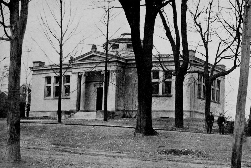
Gaylord Library, South Hadley Mass

The Gaylord Library on College Street in South Hadley, around 1904-1910. Image courtesy of the Library of Congress, Detroit Publishing Company Collection.

568_1900-1910 loc

The library in 2015:

568_2015
The epitaph on William Shakespeare’s grave warns that, “cursed be he that moves my bones,” so I suppose it is a good thing that he was never buried here in South Hadley, where the old town cemetery was moved back in 1902 to build a library. Perhaps Shakespeare would’ve approved in the name of literature, but either way the first photograph shows the site of the former cemetery, soon after it was redeveloped as the Gaylord Memorial Library.

This site was originally home to the First Congregational Church of South Hadley as well as the adjoining cemetery, but in 1894 the church burned, along with a small library that was housed inside the church.  Local philanthropist William H. Gaylord offered to donate money to build a library if the graves were moved, and the plan was approved.  The library opened in 1904, and later in the year both William Gaylord and his wife Betsey died, on the same day.  They left an endowment to maintain the library, which operated independently until 1968, when it became a branch of the South Hadley Public Library.  Because of costs, however, it reverted to an independent library in 1995, and is open to the public on a limited schedule, Thursdays through Saturdays.

Pearsons Hall, South Hadley, Mass

Pearsons Hall on the campus of Mount Holyoke College in South Hadley, around 1900-1910. Image courtesy of the Library of Congress, Detroit Publishing Company Collection.

567_1900-1910 loc

Pearsons Hall in 2015:

567_2015
Mount Holyoke College was established in 1837 as the Mount Holyoke Female Seminary, and for most of the 19th century a single building, known as the Seminary Building, housed most of the classrooms and dorm rooms, as well as the library and gymnasium. However, it burned in 1896, and the following year the school built four new dormitories, one of which was Pearsons Hall.  It is named for Dr. D.K. Pearsons, who donated money to the school to help rebuild following the fire.  Today, the building is still there, and it continues to be used as a dormitory for the college.

Samuel Warner House, Wilbraham Mass

The Samuel Warner House on Stony Hill Road in Wilbraham, on September 3, 1923. Image from Register of the Ancestors of Samuel Warner and his Descendants (1924).

562_1923-09-03 regofancestorsofsamuelwarner

The house in 2015:

562_2015

This house on Stony Hill Road was probably built in the late 1700s, and for many years it was home to some of my ancestors, starting with Samuel Warner Jr., my great-great-great-great-great grandfather.  He was a veteran of two wars, having served with his father in the French and Indian War, where they fought at Fort Ticonderoga and Fort Crown Point in New York.  He returned to Ticonderoga several decades later, when he was stationed at Fort Ticonderoga in 1776-1777 during the American Revolution.  His son, Samuel Warner III, later took over the farm, and lived here his entire life.  He died in 1824 and his son, Samuel Warner IV, my great-great-great grandfather, acquired the property following his marriage in 1827.  He was a fairly prominent citizen of Wilbraham, serving as a town selectman in 1857 and as a member of the Wesleyan Academy Board of Trustees from 1848 until 1858.  He died in 1859, and the house was later owned by two more generations until 1893, when it was sold to someone outside the family for the first time in probably over a century.

The first photo was taken during a family reunion for the Samuel Warner Association, which consists of descendants of the third Samuel Warner, who lived from 1763 to 1824.  Several of my family members are visible in the photo, including my great grandmother, who is standing 6th from the right, in the white outfit.  Her three daughters are seated together in the front row on the right, and my grandmother is the one furthest to the left, just to the right of the tear in the paper.

Today, the house is still there, but with significant modifications.  It now serves as offices for the Country Club of Wilbraham, which is located on the former Warner property.  There have been some significant additions behind and to the right of the house for dining and banquet facilities, but overall the historic house itself is still relatively intact on the exterior.

Springfield and Eastern Street Railway, Palmer Mass

A Springfield and Eastern Street Railway trolley in downtown Palmer, on Main Street opposite Bridge Street, in 1905. Image courtesy of the Palmer Public Library.

561_1905 palmerhistcom

The scene in 2015:

561_2015
The town of Palmer was once a major transportation hub, as indicated by its nickname, the “Town of Seven Railroads.” Although not all of these railroads were ever operational, at the time that the first photo was taken there were five different railroads operating in the town, but that didn’t include the many trolley lines that also served Palmer. The trolley line along Main Street belonged to the Springfield and Eastern Street Railway, and it connected Monson, Brimfield, and other points east to the city of Springfield, some 15 miles to the west. The line opened in 1898 as the Palmer and Monson Street Railway, and connected the two rapidly developing industrial towns. In 1901, the line was extended to connect with the Springfield Street Railway, and in 1905 the company was renamed to reflect its role in connecting Springfield to the towns to the east.

The first few decades of the 20th century were the heyday for trolleys, but as time went on they faced competition from buses and automobiles.  The line closed by the late 1920s, and today nothing from the first photo has survived., including the building directly behind the trolley in the 1905 scene.  It was the Converse Hotel, which at the time was conventiently located on the main road from Boston to Springfield.  Today, its former location at the corner of Main and Walnut Streets is now a parking lot.

Wales Road, Monson Mass

Looking up Wales Road from Main Street in Monson, around 1892. Image from Picturesque Hampden (1892).

560_1892c picturesquehampden

Wales Road in 2015:

560_2015
Most of the houses at the western end of Wales Road date to the second half of the 19th century, including the two on the left, which were built around 1850.  At the time that the first photo was taken, Monson was becoming a significant factory town, and many of those factories were situated in the southern part of the town center, within easy walking distance of the houses seen here.  Not long after the first photo was taken, a trolley line was built along Main Street in Monson, and it ended here at Wales Road.  Today, the trolleys are long gone, and the house on the right has since been replaced, but otherwise most of the houses in this area from the 1892 scene are still there.

Columbia Straw Works, Monson Mass

The Columbia Straw Works factory on Main Street in South Monson, around 1892. Image from Picturesque Hampden (1892).

559_1892c picturesquehampden

Main Street in 2015:

559_2015
In the second half of the 19th century, Monson developed into a significant industrial town, with the Chicopee Brook and its tributaries providing power to a number of different factories, including this facility on the left, which was built in the early 1880s by Alvin A. Gage and Rice Munn Reynolds to manufacture straw hats, which were sold at their store on Broadway in New York City.  Reynolds was the son of Monson industrialist Joseph L. Reynolds, and he had previously represented Monson in the Massachusetts House of Representatives in 1876 and 1877.  He also served as a town selectman and was one of the founders and trustees of Monson Savings Bank, which still exists today.  However, he committed suicide under rather mysterious circumstances in 1898, and his share of the business went to his brother Theodore, whose untimely death came less than two years later at the age of 57, following what the Boston Post described as “a supposedly slight illness.”  Theodore owned three mills in Monson, including this one, and was also the third largest stockholder in the Boston & Albany Railroad.  At his death, according to the Boston Post, he was worth close to $10 million, which would be around $280 million in 2015 dollars.

Following the death of Theodore Reynolds, the property was acquired by F.W.A. Langewald, who operated it as the Crescent Worsted Mill.  However, it burned within a few years.  The 1912 Hampden County atlas shows a couple small buildings on the site, but it appears that the fire marked the end of this location as a major industrial site.  Today, the only remnants of the factory itself are the stone foundations in the woods beyond the house on the right.  The small stream that once powered the factory still passes through the site, and across the street in the distance is the tenement house where many of the workers once lived.  It is the only recognizable building from both photos, and today it is an apartment building.