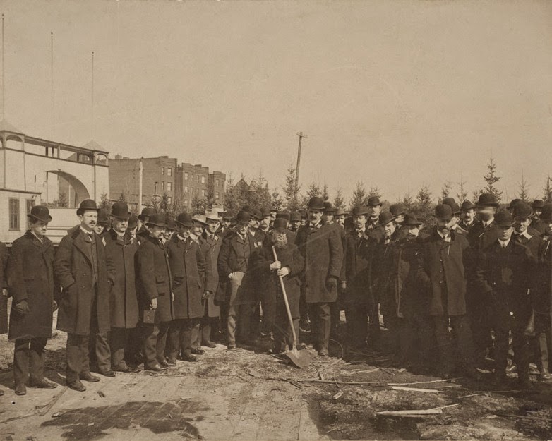
Ebenezer Hancock House, Boston

The Ebenezer Hancock House in Boston’s Blackstone Block, before 1886. Photo courtesy of Boston Public Library.
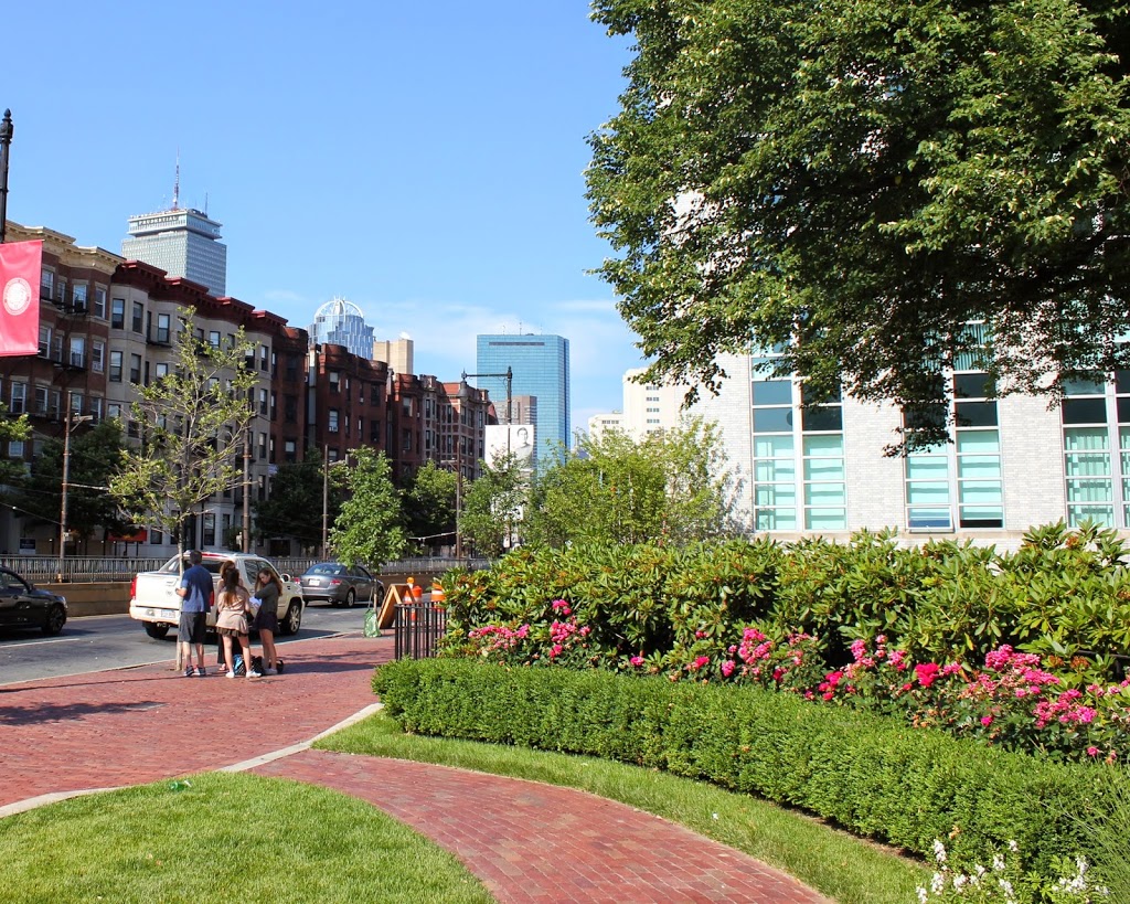
269_1800sc-bpl

The scene in 2014:

269_2014

Boston’s Blackstone Block is in an odd location; the collection of historic 18th and 19th century buildings and narrow, 16th century alleys sits as sort of a time capsule, surrounded by modern development.  On one side is the Government Center area, where street scenes like this were demolished wholesale and replaced with concrete monoliths and open paved areas, and on the other side is the Central Artery, where the elevated highway was originally built in the 1950s before being put underground as part of the Big Dig.

However, the Blackstone Block appears virtually unchanged in over 125 years.  A few notable landmarks are visible in these photos, including the Ebenezer Hancock House in the center.  In the 19th century, it was home to William H. Learnard’s shoe store, who operated out of the building from the 1820s until 1886.  He wasn’t the only person to own a shoe store here, though.  The building functioned as a shoe store from 1798 until 1963, and is today used for offices.  Originally, though, it was a house, and was built around 1767 and later owned by Ebenezer Hancock, the brother of John Hancock.

Also of note in this photo is the Boston Stone, seen in the background, embedded in the wall of the building to the left of the Ebenezer Hancock House.  Supposedly, this stone, which actually predates the circa 1835 building, was once used as the zero milestone for Boston, but this doesn’t appear to be likely.  The building, though, is probably the one thing that has changed the most since the first photo was taken.  At some point in the mid 20th century, the building was trimmed down to just three stories.  Today, it has all of its floors again, but this is a recent addition; photos in this post, from the other side of the building, show that the extra stories weren’t there in 2011.

Old Feather Store, Boston

The Old Feather Store at Dock Square in Boston, around 1860. Image courtesy of Boston Public Library.

Colonial

The location in 2014:

268_2014

The building in the 1860 photo looks like it belongs in Elizabethan England, not in 19th century Boston.  However, the building actually dates to the same century as Queen Elizabeth – it was built around 1680, and survived until around the time that this photo was taken.  Despite its age and unique architecture, historical preservation was not a major concern in the 1860s, and it was demolished.  At least one of its contemporaries survives to this day, though.  Just a few blocks up North Street (the road in the foreground of the 2014 photo) is the Paul Revere House, which was built around the same time, and is the only remaining 17th century building in downtown Boston.

As an example of the way Boston has expanded in the past few centuries, the Old Feather Store was built right on the waterfront, but by the time it was taken down, it was over a quarter mile from the harbor.  This area was originally known as Dock Square, because of its proximity to the Town Dock.  As a result, it has long been a center of commercial activity in the city.  Although the buildings that replaced the Old Feather Shop are also long gone, there is one commercial building that is in both photos; Faneuil Hall can be seen behind and to the right of the Old Feather Shop, and on the right-hand side in 2014.

Copp’s Hill Burying Ground, Boston

Copps Hill Burying Ground, around 1904. Image courtesy of the Library of Congress, Detroit Publishing Company Collection.

Cemeteries

The cemetery in 2014:

267_2014

It’s almost a little eerie to see how little the cemetery has changed in the past 110 years.  Many of the headstones are even still tilted the same way as they were in 1904, and a few of the trees are still there; the tall, skinny tree in the 1904 photo just to the left of the corner of the building in right-center appears to be the same one that is there today.

The cemetery is located just up the hill from Old North Church, and is a stop on the Freedom Trail in Boston’s North End.  Although it doesn’t have as many famous interments as the Granary Burying Ground, there are still some notable people buried here, including Puritan ministers Increase and Cotton Mather, and Edmund Hartt, a shipbuilder whose most famous work, the USS Constitution, still sits right across the harbor from here.

Scollay Square, Boston

Scollay Square in Boston, around 1906. Image courtesy of the Library of Congress, Detroit Publishing Company Collection.

266_1906c-loc

The same scene in 2014:

Scollay Square is one of the more dramatic, and perhaps infamous examples of urban renewal in Boston.  Located at the corner of Tremont and Court streets, it was a busy commercial center for several centuries.  However, by the 1950s it was a seedy neighborhood with low-income residents, so the entire area was demolished in the 1960s and replaced with Government Center, which included City Hall and City Hall Plaza (just to the right of where the 2014 photo was taken).

The two small buildings in the center of the square in the 1906 photo are two different subway stations; the one in the foreground is Court Street on the East Boston Tunnel (present-day Blue Line), and the larger, more ornate one in the background is the Scollay Square station on the Tremont Street Subway (today’s Green Line).  This was the original terminus of the East Boston Tunnel when it opened in 1904; it extended from Maverick Station in East Boston, and ran under Boston Harbor and up State Street to here.  In 1916, the line was extended to Bowdoin, and the Court Street Station was closed, and a new station was opened under the Scollay Square station; not surprisingly, it was called Scollay Under.

Today, very little remains from the 1906 photo.  Only two buildings survive; the one on the far left (modern-day Bank of America), and the Suffolk County Courthouse, visible in the distance in left-center (and no longer visible from this spot today, although it’s still there).  Even the subway station has changed; the Blue and Green lines still meet here, but it is now the Government Center station, and the entrance is further to the right, at City Hall Plaza.  The station itself was reconstructed in the 1960s, and is currently being reconstructed again.  It was closed earlier this year, and is not scheduled to reopen until 2016.

Arlington Street Church, Boston

Arlington Street Church in Boston, around 1862.  Photo taken by J.J. Hawes, courtesy of Museum of Fine Arts, Boston.

ArlingtonStChurch_ca1862_byJJHawes_MFABoston

The church around 1904. Image courtesy of the Library of Congress, Detroit Publishing Company Collection.

264_1904c-loc

The church in 2014:

264_2014

For the first two centuries of Boston’s history, this location was right on the waterfront. However, as the city grew in population, they needed more land, so by the 1850s, the city started filling in the Back Bay, adding new real estate along the Charles River from the Public Garden (seen in the lower right of the 1904 photo) to the Kenmore Square area.  The Arlington Street Church, completed in 1861, was one of the first buildings to be constructed on the newly-created land.  The first photo shows the neighborhood just as it began to be developed; plenty of empty land beyond the church is visible in the space between it and the apartment building to the right.  Today, it remains an active church, and aside from no longer having ivy on its walls, it looks very much the same as it did 110 years ago.

South Station, Boston

South Station around the time that it opened in 1899. Image courtesy of the Library of Congress, Detroit Publishing Company Collection.

263_1899c-loc

The same view around 1905, after the construction of the Atlantic Avenue Elevated. Image courtesy of the Library of Congress, Detroit Publishing Company Collection.

Transportation

South Station in 2014:

These three photos reveal the changes that have taken place here at South Station over the past 115 years.  While the building itself (or at least most of it) has remained essentially the same, its surroundings have continually changed.

Before 1899, four different railroads had terminals in the general vicinity of the present-day station.  To make things simpler, South Station was built, and all four lines were rerouted to it.  A few years later, in 1901, the Atlantic Avenue Elevated was built, as seen in the second photo.  The rapid transit line included a station at South Station, which can be seen on the far right of the 1905 photo.

The third photo shows the result of changes in the way people travel; the Atlantic Avenue Elevated closed in 1938, and was demolished four years later.  Even South Station was seeing a severe drop in passengers in postwar America, as cars became the primary method of travel.  However, Boston’s colonial-era street network was not particularly accommodating to large number of cars, so the Central Artery was built in the 1950s.  Most of the Central Artery was elevated, but it was put underground for a few blocks near South Station, and was known as the Dewey Square Tunnel.

The Dewey Square Tunnel turned out to be a foreshadowing of things to come; part of Boston’s infamous Big Dig involved putting the entire Central Artery underground.  Today, the tunnel is still there, directly underneath where I was standing when I took the photo.  It is the only existing part of the Central Artery; the remainder of the 1950s-era expressway was demolished upon completion of the Big Dig.

Today, South Station has been trimmed a bit – notice that the facade on both sides is shorter than in the first two photos.  This was a result of demolition in the 1960s, at a time when many railroads were cutting back or eliminating passenger service.  However, today South Station is a busy transportation center again – it is the busiest railroad station in New England and the sixth busiest in the country, and it is the northern terminus of the Northeast Corridor, the busiest rail line in the country.