King’s Chapel Burying Ground, Boston

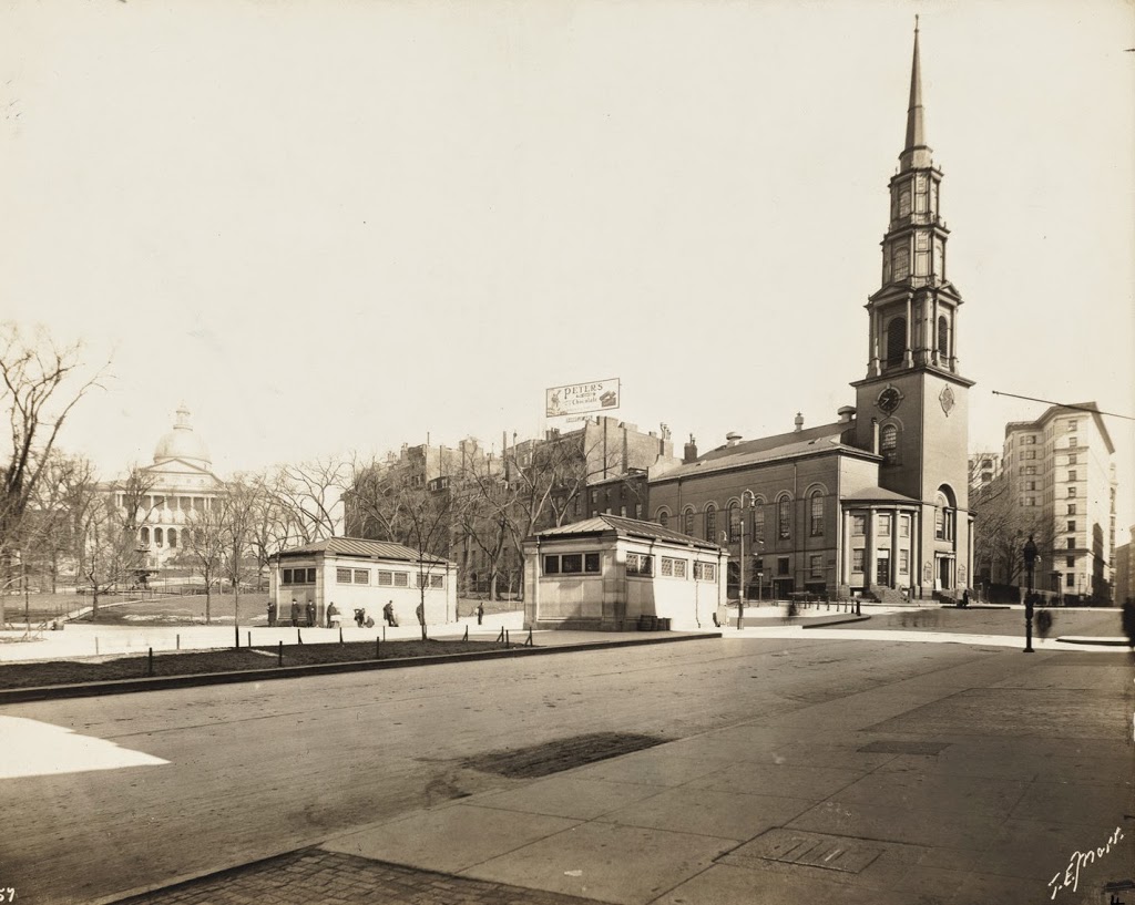
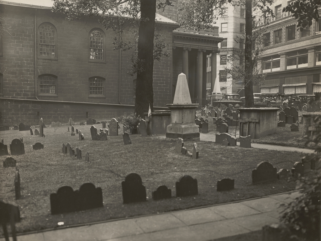
The scene in the King’s Chapel Burying Ground in Boston, around the 1920s. Image courtesy of the Boston Public Library.
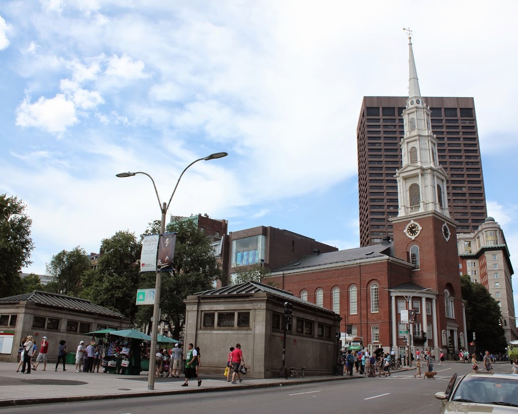
The scene in 2021:

King’s Chapel Burying Ground is the oldest cemetery in Boston, dating back to the very beginning of the European colonization of the area. According to tradition, the first burial here was Isaac Johnson, one of the wealthiest and most influential of the original settlers of the Massachusetts Bay Colony. He had extensive landholdings, but he died in September 1630, only a few months after his arrival in the New World. As the story goes, Johnson was buried on his property in Boston, and as other people died in the coming months and years, they were likewise buried here.

In reality, there is no contemporary evidence to indicate that Johnson was even buried in Boston, let alone in this specific plot of land. The earliest account of this story was written nearly 50 years after the fact, in the diary of Judge Samuel Sewall. But, one way or another, this site became a burial ground very early in Boston’s history, although the exact date is uncertain. It would remain the town’s only cemetery until 1659, when Copp’s Hill Burying Ground was established in the North End.

There are no surviving gravestones from the early burials here. The oldest is dated 1658, for William Paddy, although this stone had an interesting history. Paddy was presumably buried here at King’s Chapel, but the gravestone itself was discovered buried under the street next to the Old State House in 1830. It seems highly unlikely that Paddy would have been buried there, and there were no human remains in the vicinity, so the stone was probably removed from the burying ground at some point, perhaps in the 1700s, and repurposed as something else. In any case, it was safely returned here after its discovery in 1830, and has remained here ever since.

Gravestones became more common here during the late 1600s and early 1700s, often with highly ornate, intricate carvings decorated with images of skulls and other symbols of death. Perhaps most notable among them is the gravestone of Joseph Tapping, a large slate stone that stands at the entrance to the graveyard. It is dated 1678, and it features a scroll pediment at the top, and beneath it is a large hourglass atop a winged skull. Beneath the skull is a striking image of a skeleton, likely symbolizing death, trying to extinguish a candle while Father Time tries to restrain him. Another notable gravestone is that of Elizabeth Pain, dated 1704. It likewise features a skull and hourglass, but it also has a large coat of arms carved into it. This design somewhat resembles a capital “A,” which has led some to speculate that this gravestone inspired Nathaniel Hawthorne to write The Scarlet Letter.

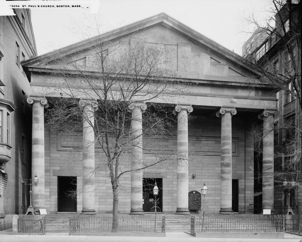
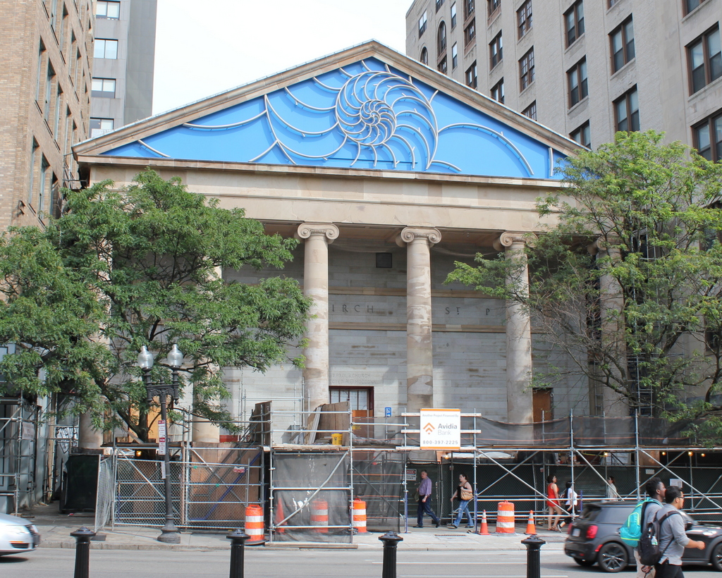
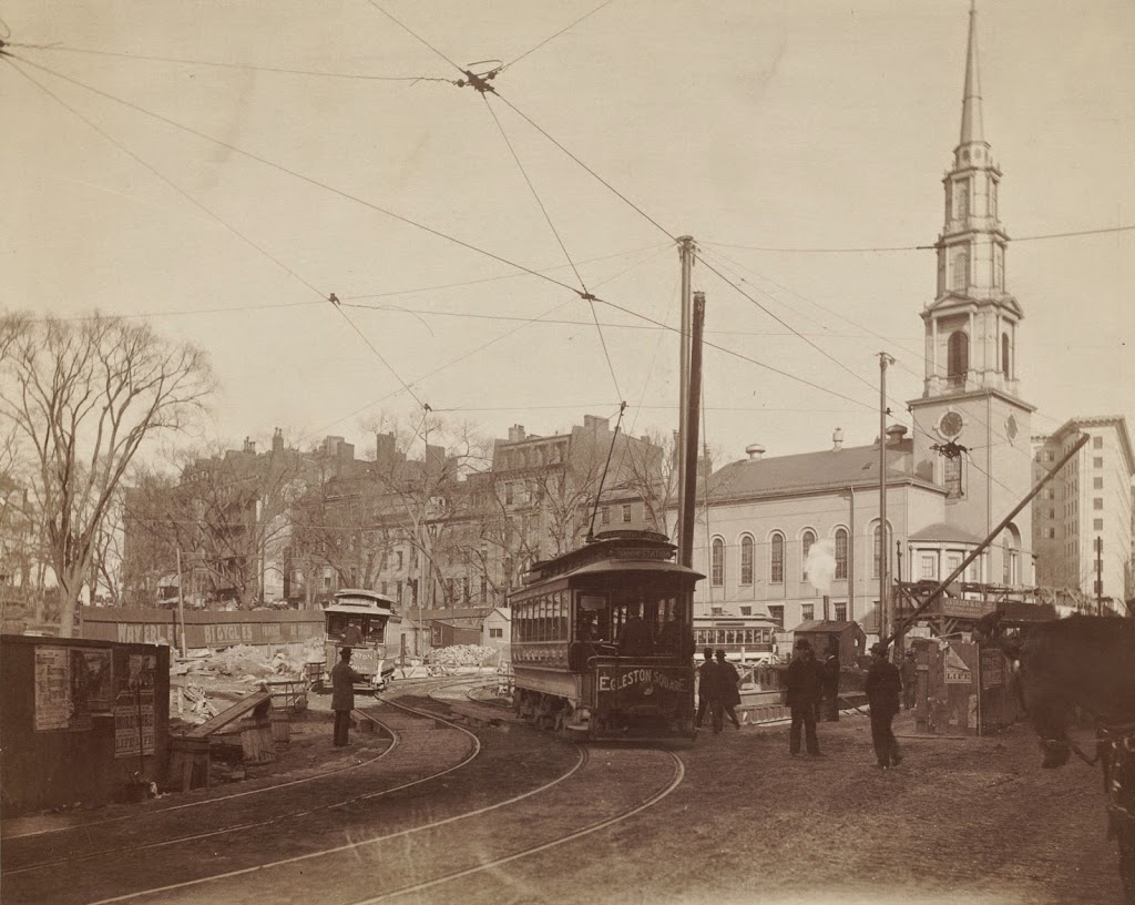
In the meantime, in 1688 King’s Chapel was built on the southern portion of the graveyard. It was the first Anglican church in a town that was otherwise dominated by Puritanism, and this was the only land that the church officials were able to acquire. It was originally built of wood, although it was later rebuilt with stone in 1754, as shown in these two photos. The church was not at all affiliated with the graveyard, but, because of its proximity, it came to be known as King’s Chapel Burying Ground, and the name has stuck ever since.

The graveyard continued to be used throughout the 18th and into the early 19th centuries. However, by that point Boston was growing rapidly, and the old burial grounds such as this one were becoming overcrowded and, in the minds of many, posed health risks. So, in 1831 the Mount Auburn Cemetery was established in Cambridge and Watertown, in the suburbs of Boston. In contrast to the crowded, urban setting here, this new cemetery would be laid out like a rural park. And, while the old graveyards featured gravestones with grim, Puritan-era reminders of death, Mount Auburn would have monuments that were generally more neoclassical in style.

By the time the first photo was taken around the 1920s, King’s Chapel Burying Ground had not been used as an active cemetery for many decades. And, in the meantime, many of the old gravestones had been rearranged during the 19th century, evidently to create more orderly rows of stones. As a result, the location of many of the stones no longer corresponded to the site of the remains that they were intended to mark. This practice continued after the first photo was taken, and today the arrangement of the stones is very different from a century ago, as shown in the present-day photo.

Today, King’s Chapel Burying ground is a popular stop on the Freedom Trail, and a nice summer day will find many tourists circulating through the old graveyard. None of the particularly famous gravestones are readily visible in this scene, although the obelisk in the center of the photo stands out amid the otherwise relatively small colonial-era stones. It marks the gravesite of Thomas Dawes, a builder and architect who was also a militia colonel during the American Revolution. Just beyond the obelisk is a tomb that was long believed to have been the final resting place of William Dawes Jr., Thomas’s cousin. He had been one of the riders who, along with Paul Revere, warned of the advancing British redcoats before the Battles of Lexington and Concord. However, it appears that he is actually buried at the Forest Hills Cemetery in Jamaica Plain.

Aside from the graveyard itself, a few of the surrounding buildings are still standing from the first photo. Most notably is King’s Chapel itself, which remains an active church, although it has been a Unitarian congregation—rather than Anglican—ever since the end of the American Revolution. Further in the distance, on the right side of the scene, the other survivor from the first photo is the Tremont Building. Constructed in 1895, this office building still stands at the southwest corner of Tremont and Beacon Streets, and it is currently part of the Suffolk University campus.

Scollay Square, Boston

Scollay Square, looking north from the corner of Tremont and Court Streets, sometime in the 1860s. Image courtesy of the Boston Public Library.

823_1860-1869c bpl

Scollay Square on August 26, 1897. Image courtesy of the City of Boston Archives.

823_1897_08_26 coba

Scollay Square around 1942. Image courtesy of the Boston Public Library, Leslie Jones Collection.

823_1942c bpl

The scene in 2015:

823_2015
These four photos reveal the dramatic transformations that have occurred at Boston’s Scollay Square over the past 150 years. The square once included a long, narrow row of buildings in the middle, which appear on city maps as early as the 1720s. The construction date for the building in the first photo is unknown, but it was once at the southern end of this row, and in 1795 it was purchased by William Scollay, a real estate developer for whom the square would eventually be named. By the time the first photo was taken, all of the other buildings in the middle of the square had been demolished, and Scollay’s building was taken down soon after, around 1870.

The second photo shows a very different scene. Some of the buildings along the square are still standing, but the Scollay Building is gone, as are the horse-drawn trolleys from the first photo. Instead, they have been replaced by electric trolleys, like the one shown in the photo. However, these would not last long, at least not on the surface. The second photo was taken only about a week before the Tremont Street Subway opened, and the photo shows some of the construction activity as the workers prepared the Scollay Square station for its opening day on September 3. The station itself is not visible, but its ornate entrance can be seen in this post, which shows the scene from a slightly different angle.

Scollay Square had long been a major commercial center in the city, but by the time the third photo was taken in the 1940s, it had seen a dramatic decline. Many of the old buildings were still standing, but the businesses had become seedier. The 1942 photo shows a number of bars, liquor stores, cheap restaurants, and burlesque theaters, and the area was particularly popular among sailors on leave from the Boston Navy Yard and college students from the many nearby schools. One prominent hotel and theater in both the second and third photos was the Crawford House on the far right. It was built in 1865 and underwent several renovations, including one in 1926 that completely altered the front. The building burned in 1948, and all but the first two floors were demolished a few years later.

By the 1950s, the area was being targeted for urban renewal. Looking to replace the area with something more respectable, the Boston Redevelopment Authority demolished over a thousand buildings in the vicinity to build the Government Center complex, which includes the Center Plaza to the left, the John F. Kennedy Federal Building in the center, and the Boston City Hall, just out of view to the right. The old Scollay Square subway station was also extensively renovated and renamed Government Center. When the last photo was taken, the station was undergoing a another renovation, so if there is one thing that the second and fourth photos have in common, it is subway station construction.

Cathedral Church of St. Paul, Boston

The Cathedral Church of St. Paul on Tremont Street in Boston, around 1900-1910. Image courtesy of the Library of Congress, Detroit Publishing Company Collection.

713_1900-1910c loc

The building in 2015:

713_2015
This historic church was built in 1819 as St. Paul’s Church, making it the third Episcopal congregation in the city after Old North Church and Trinity Church.  It was designed in the Greek Revival style by Alexander Parris, whose other works in the Boston area include the United First Parish Church in Quincy as well as Quincy Market in Boston.  All three of these buildings still stand today, and all of them clearly show the Greek Revival influence of Parris’s work.

Only a few years after the first photo was taken, the church became the cathedral for the Episcopal Diocese of Massachusetts, and it has served in that role ever since, even as the buildings around it have grown taller over the years.  As of the 2015 photo, the church was under renovation, which explains the construction area in front.  The most obvious change to the exterior, though, is the design on the pediment.  The church’s original design called for a relief design of Paul preaching to King Agrippa II, but it never came about.  Instead, in 2013, the church added the nautilus shell design with the bright blue background, which looks completely out of place on a 196 year old Greek Revival church.  As one Episcopal priest put it, “it looks more like the entrance to a fancy seafood restaurant than a cathedral.”

Boylston Station, Boston

The Boylston subway station, at the corner of Tremont and Boylston Streets in Boston, on August 12, 1897. Image courtesy of the City of Boston Archives.

687_1897-08-12 coba

The station in 2015:

687_2015
The first photo captures the ending of one era and the beginning of another.  Just a few weeks after the photo was taken, the trolleys that are seen here on congested Tremont Street would be moved underground, giving Boston the distinction of having the country’s first subway tunnel.  The first two stations were Park Street, just over a quarter mile to the north, and this one here at Boylston Street, in the southeast corner of Boston Common.  The project was a major civil engineering milestone, but it didn’t come without tragedy.  At this location earlier in the year, a leaking gas line in the work area under the intersection caused an explosion that killed six people.  The explosion is explained further in this post, which features photos that were taken diagonally across the street from here.

Today, the view really hasn’t changed too much.  The trolleys on the Green Line are still running under this intersection, the distinctive station entrances are still here, as is Boston Common in the background.  Even in the 19th century, this intersection of Boylston and Tremont streets was busy, necessitating the police officer in the left center of the 1897 photo.  The slow shutter speed of the camera has blurred most of the traffic around him, but he is standing perfectly still, posing for the photographer as trolleys, carriages, and pedestrians pass by.  It is still a major intersection today, albeit without the nostalgia of a 19th century officer directing traffic on a cobblestone street.

Park Street Station, Boston

Tremont Street during construction of the Park Street subway station in 1897. Photo courtesy of Boston Public Library.

336_1897-2Bbpl

Park Street Station after completion, taken in 1906. Photo courtesy of Boston Public Library.

336_1906-2Bbpl

Park Street Station in 2014:

336_2014

As mentioned in previous posts, the Tremont Street Subway (today’s MBTA Green Line) was the first subway in the country, and Park Street was one of the first two stations, along with Boylston.  The station opened in 1897, and helped to relieve congestion on Tremont Street by removing the trolleys from the surface, as seen in the first photo.  Today, the station is still there, as is Park Street Church behind it.

See this post and this post for a few photos of the interior of the station.

Tremont Street Trolleys, Boston

Looking up Tremont Street toward Park Street Church in Boston, in 1895. Photo courtesy of Boston Public Library.

335_1895-2Bbpl

Tremont Street in 2014:

335_2014

These photos were taken from almost the same spot as the ones in this post and this post, but the first one here shows Tremont Street as it appeared before the construction of the Tremont Street Subway.  By the time the 1895 photo was taken, Tremont Street was becoming crowded with traffic, from pedestrians to carriages and even trolleys, as seen in the distance of the first photo.  Toalleviate the congestion, the trolley lines were put underground, making this the first subway in the country.  Today, Tremont Street is still a busy road, but trolleys such as the green and orange one in the 2014 photo are purely for tourism – the real trolleys still run underground through here on the MBTA Green Line.