Great Gulf, Mount Washington, New Hampshire

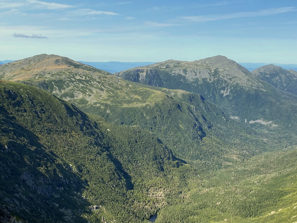
The Great Gulf, seen from just north of the summit of Mount Washington, around 1900. Image courtesy of the Library of Congress, Detroit Publishing Company Collection.
The scene in 2021:

These two photos show the view looking north from Mount Washington, with the Great Gulf in the foreground and the summits of the northern Presidential Range beyond it. Mount Washington is the highest peak in New England and the northeastern United States, and it stands at the center of the Presidential Range, a north-south oriented range that contains many other high peaks. The five highest peaks are named after the first five presidents, mostly in descending order of elevation, and each one is higher than any other mountain in the northeast outside of the Presidential Range.

Mount Washington, the highest, is 6,288 feet above sea level. It is followed by Mount Adams (5,774 feet), which is seen on the right side of this scene; Mount Jefferson (5,712 feet) on the left side of the scene; Mount Monroe (5,384 feet) out of view on the opposite side of Mount Washington; and Mount Madison (5,367 feet) on the extreme right-hand side of this scene.

Just out of view in the foreground on the right side is a portion of Mount Washington, which extends to the northeast away from the summit area. That slope of Mount Washington, along with the northern Presidentials in the distance, form the walls of the Great Gulf, a large glacial cirque. There are a number of different cirques around Mount Washington that were formed by glacial activity, including Tuckerman Ravine, Huntington Ravine, and Ammonoosuc Ravine. However, the Great Gulf is by far the largest of these, extended more than two miles in length and over a mile in width.

The first recorded description of the Great Gulf comes from Darby Field in 1642. Although this was still very early in the history of European colonization in New England, and several centuries before recreational hiking became popular in the region, Darby Field and his two Native American guides became the first known people to have climbed Mount Washington. This achievement was considered remarkable enough that John Winthrop, governor of the Massachusetts Bay Colony, provided a lengthy account of Field’s expedition in his journal. Regarding the final ascent to the summit, Winthrop wrote:

They went divers times through the thick clouds for a good space, and within 4 miles of the top, they had no clouds but very cold. By the way among the rocks, there were two ponds, one a blackish water, and the other reddish. The top of all was plain about 60 feet square. On the north side was such a precipice, as they could scarcely discern to the bottom. They had neither cloud nor wind on the top, and moderate heat. All the country about him seemed a level, except here and there a hill rising above the rest, and far beneath them. He saw to the north, a great water which he judged to be 100 miles broad, but could see no land beyond it.

Although Winthrop’s description was secondhand information at best, the account seems reliable, since it contains information that Field would only have known if he had actually reached the summit. The “two ponds” are likely the Lakes of the Clouds, located along the ridgeline between the summits of Mount Washington and Mount Monroe, and the description of the “plain” at the summit likewise corresponds to reality. And, his description of the Great Gulf also helps to verify the account, since Field would have only known about “such a precipice, as they could scarcely discern to the bottom” if he and his guides had actually stood here at the edge of the Great Gulf headwall.

Aside from Field’s journey, there were very few recorded ascents of Mount Washington during the colonial period. However, this began to change by the early 19th century, as New Englanders began to travel to the White Mountains to experience the scenery here. By 1819 there was a footpath from Crawford Notch to the summit, and this was later followed by a carriage road in 1861 and a cog railway in 1868. The summit area became a seasonal community, with several hotels and even its own newspaper.

However, despite the extensive development on Mount Washington, the other summits on the Presidential Range remained largely untouched, as did the Great Gulf. Visitors were generally happy to admire these scenes from afar, and there were few landscapes that could compete with this view here in these photos. Writing in his 1856 book Incidents in White Mountain History, Benjamin G. Willey provided the following description of this scene:

[G]oing a few rods northward, you come to the brink of an almost unfathomable abyss, known as the Great Gulf. It is a rocky, precipitous descent of two thousand feet. Rising up opposite you from the bottom of this Gulf, almost perpendicularly, is the great range of mountains, comprising Clay, Jefferson, Adams and Madison. This vast range may be seen from their roots to their summits by one standing on the brink. Deep down in the very bottom of the hollow are rough, confused piles of rocks, with narrow and deeply-worn ravines between them. Springing up occasionally, near the very base of the mountain range, are tall spruces, while further up on their sides are birches and small firbushes. Toward the east, the Gulf has an opening, surrounded on all its other sides by mountains.

A few years later, in his 1860 book The White Hills: Their Legends, Landscape, and Poetry, described the scene in even more rapturous language, from an overlook on the nearby carriage road. He wrote:

Yet the glory of the view is, after all, the four highest companion mountains of the range. Clay, Jefferson, Adams, Madison, that show themselves in a bending line beyond the tremendous gorge at the right of the path, absurdly called the ” Gulf of Mexico,” and are visible from their roots to their summits. . . . Except by climbing to the ridge through the unbroken wilderness of the northern side, there is no such view to be had east of the Mississippi of mountain architecture and sublimity. They do not seem to be rocky institutions. Their lines have so much life that they appear to have just leaped from the deeps beneath the soil. We say to ourselves, these peaks are nature’s struggle against petrifaction, the earth’s cry for air.

This scene certainly captivated visitors, but few were adventurous enough to actually descend into this “unfathomable abyss.” Because of its remoteness, the upper reaches of the Gulf escaped large-scale logging, and even the trail builders of the late 1800s tended to avoid the area. A single hiking trail was built through the Gulf as far as Spalding Lake in the lower foreground of these photos, but it did not ascend the headwall of the mountains. Nor did it apparently see much use, because it did not see much subsequent maintenance.

The Great Gulf was still an essentially trailless wilderness when the first photo was taken around 1900, but this would soon change. From 1908 to 1910, Warren W. Hart oversaw the construction of a series of trails in the area, starting with the Great Gulf Trail, which traversed the Gulf, climbed the headwall, and ended near the spot where these two photos were taken. Another trail, named the Six Husbands Trail, was opened to the summit of Mount Jefferson by way of the steep slopes in the right-center of the scene. Two other trails—Adams Slide and the Buttress Trail—climbed Mount Adams, and the Wamsutta and Chandler Brook Trails climbed the northeastern slopes of Mount Washington from the Great Gulf.

At the time, the Great Gulf was still in private hands, but in 1916 it was purchased by the U.S. Forest Service. It subsequently became part of the White Mountain National Forest, and in 1964 it was designated as the Great Gulf Wilderness, which conferred greater protections on the land than other portions of the national forest. As a result, this view from atop the headwall looks essentially the same as it did over 120 years earlier, and in all likelihood it also looks the same as it did over 380 years ago, when Darby Field first described the “precipice” where he could “scarcely discern the bottom.”

Boston Light

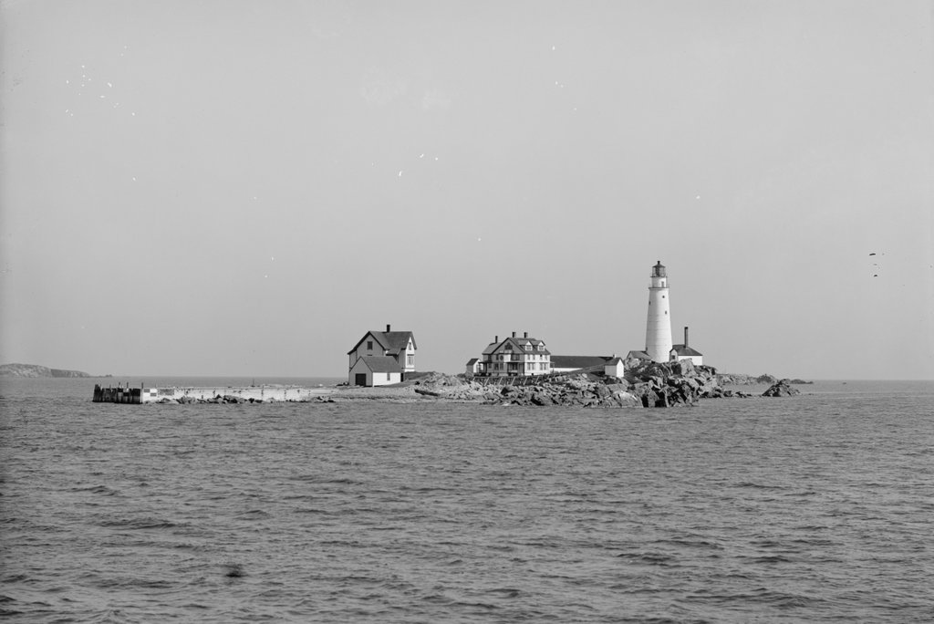
Boston Light on Little Brewster Island in Boston Harbor, around 1906. Image courtesy of the Library of Congress, Detroit Publishing Company Collection.

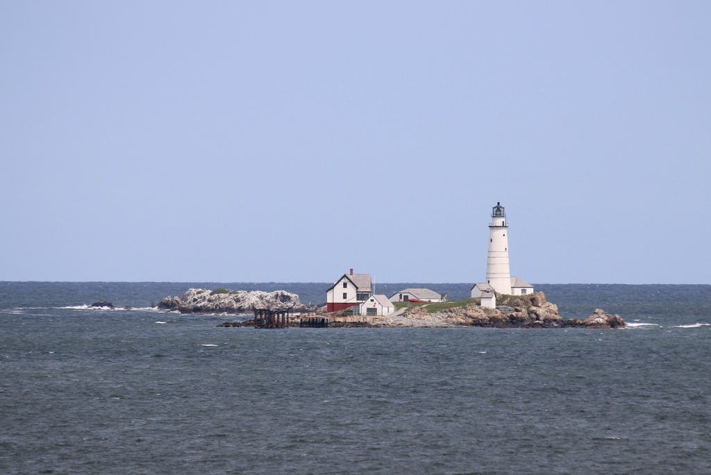
The scene in 2021:

These two photos were not taken from the exact same angle; the first one was probably taken from a boat near the island, while the second one was taken with a telephoto lens from about two miles away on Georges Island. But, they both show essentially the same view of Little Brewster Island, the site of the first lighthouse in the present-day United States and the second-oldest existing lighthouse in the country.

During the colonial era, Boston was one of the most important seaports in British North America. Boston benefited from a large natural harbor, protected from the open ocean by a number of islands and peninsulas, but these same landforms also posed hazards to ships entering and leaving the harbor. So, to protect ships and the lives of their sailors, the first lighthouse in the British colonies was constructed here on Little Brewster Island, a small outcropping near the outer edge of the harbor. It was about 60 feet tall, built of rubble masonry, and it was lit for the first time on September 14, 1716.

The occasion was noted in The Boston News-Letter three days later, with the paper describing:

Boston, By vertue of An Act of Assembly made in the First Year of His Majesty’s Reign, For Building & Maintaining a Light House upon the Great Brewster [sic] (called Beacon Island) at the Entrance of the Harbour of Boston, in order to prevent the loss of the Lives & Estates of His Majesty’s Subjects; The said Light House has been built; And on Fryday last the 14th Currant the Light was kindled, which will be very useful for all Vessels going out and coming in to the Harbour of Boston, or any other Harbours in the Massachusets-Bay, for which all Masters shall pay to the Receiver of Impost, One Peny per Ton Inwards, and another Peny Outwards, except Coasters, who are to pay Two Shillings each, at their clearing Out. And all Fishing Vessels, Wood Sloops, etc. Five Shillings each by the year.

The first lighthouse keeper was George Worthylake, but he would soon become the first American lighthouse keeper to die in the line of duty. On November 3, 1718, he was returning to the lighthouse accompanied by his wife Ann and their daughter Ruth, along with an enslaved man, a servant, and a friend of the family. They took a sloop back to the vicinity of island, then boarded a canoe to make their landing. However, the canoe capsized, and all six people drowned.

Here again, The Boston News-Letter reported the tragedy:

Boston, On Monday last the 3d Currant an awful and Lamentable Providence fell out here, Mr. George Worthylake (Master of the Light-House upon the Great Brewster (called Beacon-Island) at the Entrance of the Harbour of Boston) Anne his Wife, Ruth their Daughter, George Cutler, a Servant, Shadwell their Negro Slave, and Mr. John Edge a Passenger; being on the Lord’s Day here at Sermon, and going home in a Sloop, drop Anchor near the Landing place and all got into a little Boat or Cannoo, designing to go on Shoar, but by Accident it overwhelmed, so that they were Drowned, and all found and Interred except George Cutler.

Although the article does not mention the specific burial place, George, Ann, and Ruth were all buried in Copp’s Hill Burying Ground, beneath a triple headstone that still survives today.

Aside from this article in the News-Letter, other writers covered the event. Perhaps most famously, 12-year-old Benjamin Franklin wrote a ballad, which he titled “The Lighthouse Tragedy.” No copies of the poem are known to survive, but in his autobiography Franklin referenced this and another similar poem that he wrote about Blackbeard, observing that:

They were wretched stuff, in the Grub-street-ballad style; and when they were printed he sent me about the town to sell them. The first [the lighthouse poem] sold wonderfully, the event being recent, having made a great noise. This flattered my vanity; but my father discouraged me by ridiculing my performances, and telling me verse-makers were generally beggars. So I escaped being a poet, most probably a very bad one.

In the meantime, the lighthouse continued in operation under a new keeper, and in 1719 a cannon was installed on the island for use as a fog signal. The tower was badly damaged by a fire in 1751, but it was subsequently repaired and remained in use until the start of the American Revolution. It was ultimately destroyed by the British on July 13, 1776, following their evacuation of Boston several months earlier.

Little Brewster Island remained devoid of a lighthouse for the rest of the American Revolution, but as the war was winding down in 1783 the Massachusetts legislature authorized the funding to construct a new lighthouse here. It was completed by the end of the year, and like its predecessor it was built of rubble masonry. However, it was somewhat taller, standing 75 feet in height. This tower, with some alterations over the years, is still standing today, as shown in the two photos in this post.

The lighthouse was completed prior to the current U.S. Constitution. At the time, the national government had very limited powers, so matters such as lighthouses were the responsibility of the individual states. Under the new Constitution, though, this became a part of the role of the federal government, which took over the operation of Boston Light in 1790.

Over the years, the exterior appearance of the lighthouse changed several times. In 1809, in response to large cracks in the walls, six iron bands were installed around the tower in order to provide additional structural support. Then, in 1859 the height of the tower was increased to 89 feet, and a new second-order Fresnel lens was installed in the lantern. Also during this time, the interior of the tower was lined with brick, and a brick entryway was added to the base of the tower.

By the time the first photo was taken around 1906, the lighthouse was joined by a number of other buildings on the island. Among these were two houses for the lighthouse keepers, along with ancillary structures such as the fog signal, cistern, oil house, and boathouse. The boathouse was situated next to a pier, and it was equipped with a marine railway. At the time, the light station was staffed by a head keeper and two assistant keepers, and they often lived here with their families as well.

Although still in active use as a lighthouse, the importance of Boston Light had diminished somewhat by the time this photo was taken. Around the turn of the 20th century, most large vessels began taking a more northerly channel into Boston Harbor, bypassing the old lighthouse. To accommodate this traffic, a new lighthouse was constructed in 1905 at the Graves, a rocky ledge about three miles to the northeast of Boston Light. This new lighthouse was taller than Boston Light, and it was also equipped with a larger first-order Fresnel lens.

Despite these changes in shipping routes, Boston Light remained an important lighthouse. There were some changes here in 1939, when the U.S. Lighthouse Service was absorbed by the Coast Guard, and there were further changes during World War II, when the light was extinguished for security purposes, although it was relit after the war. Then, in the postwar era, the role of lighthouse keepers started to become redundant, and lighthouses across the country were steadily automated, which eliminated the need for light stations that were staffed full time. However, just as Boston Light was the first lighthouse in the country, it was also the last one to be automated, in 1998.

Today, this scene is still easily recognizable from the first photo more than 115 years later. The large duplex keeper’s house is gone, having been deliberately burned in 1960, and the pier was destroyed during the blizzard of 1978.  Overall, though,  most of the other buildings are still here, including the 1884 keeper’s house, the 1899 boathouse, the 1889 oil house, and the 1876 fog signal building, which now also houses a generator. And, of course, the lighthouse is still here, with few exterior changes aside from the removal of one of the metal bands, leaving only five in its current appearance. It is the second oldest active lighthouse structure in the country, predated only by the 1764 Sandy Hook Light in New Jersey.

Despite being automated in 1998, Boston Light is still staffed by a resident keeper, although this is largely a ceremonial role. Along with most of the other harbor islands, Little Brewster Island is now part of the Boston Harbor Islands National Recreation Area. Unlike some of the larger islands, there is no ferry service or public access to Little Brewster, although the lighthouse can be seen from passing boats, from the mainland in Hull, or from Georges Island, as shown in the present-day photo.

Old Patent Office Building, Washington, DC (2)

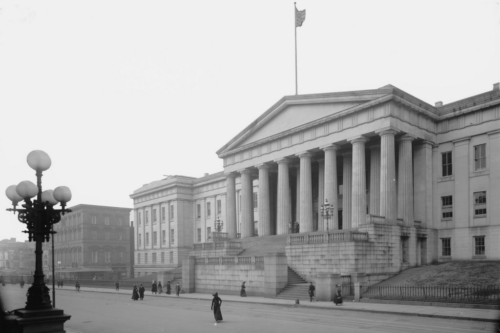
The south entrance to the Old Patent Office Building on F Street NW in Washington, DC, around 1900-1906. Photographed by William Henry Jackson; image courtesy of the Library of Congress, Detroit Publishing Company Collection.

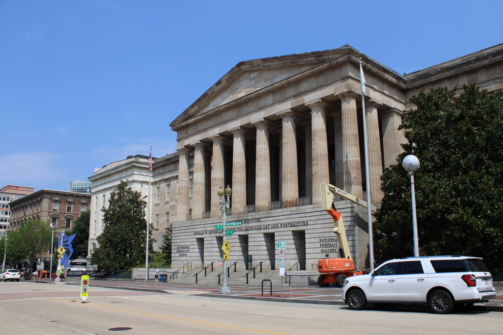
The scene in 2021:

As explained in the previous post, this building was constructed between 1836 and 1867 as the home of the Patent Office. The oldest section, which opened in 1840, is shown here in the foreground, and it can be distinguished from the rest of the building by its darker-colored sandstone exterior. It was designed by architect Robert Mills in the Greek Revival style, and the entrance here on F Street NW once had a large staircase leading up to the portico, as shown in the first photo.

This staircase was eventually removed in 1936 when the street was widened, but the rest of the building avoided possible demolition in the 1950s, when there had been a proposal to replace it with a parking lot. It was ultimately preserved, was designated as a National Historic Landmark, and it is now the home of the Smithsonian American Art Museum and the National Portrait Gallery.

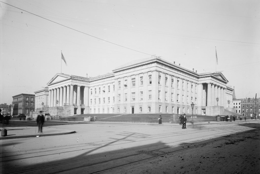
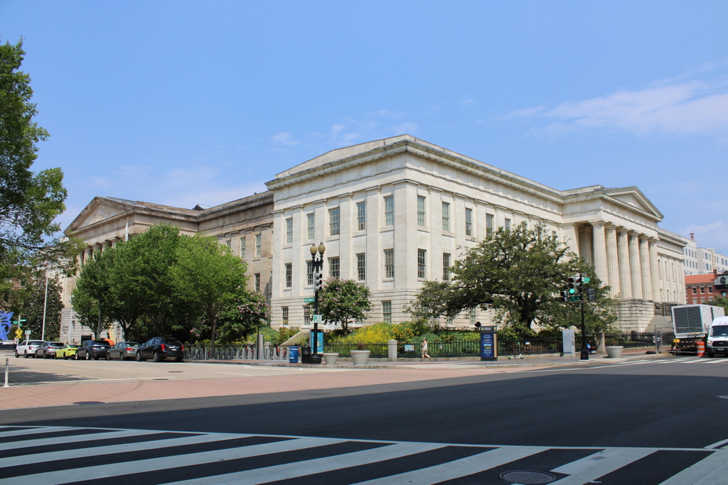
Old Patent Office Building, Washington, DC

The Old Patent Office Building, seen from the corner of 7th Street NW and F Street NW in Washington, DC, around 1900. Image courtesy of the Library of Congress, Detroit Publishing Company Collection.

The building in 2021:

These two photos show the Old Patent Office Building, which was constructed in stages between 1836 and 1867. The building has a roughly rectangular footprint, with a courtyard in the center, and it occupies the entire block between F Street NW, G Street NW, 7th Street NW, and 9th Street NW. It was designed by prominent architect Robert Mills, with a Greek Revival style that was popular for public buildings of this era.

The oldest part of the building is the southern wing, shown here on F Street NW on the left side of the scene. It was completed in 1853, and it can be distinguished from the rest of the structure by the darker-colored sandstone exterior, in contrast to the lighter-colored marble of the later wings on the east and west. This wing originally had a large staircase at the main entrance, as shown in the first photo, but this was removed in 1936 when the street was widened.

The primary purpose for this building was to serve as a repository for models of new inventions, which had to be submitted as part of the patent process. However, the building also served a number of other roles in its early years, including as the home of the Department of the Interior from 1852 to 1917, as a hospital and barracks in the aftermath of the Battle of Antietam in 1863, and as the site of Lincoln’s second inaugural ball in 1865.

The building suffered a major fire in 1877 that caused significant damage to the building and the loss of many patent models, but it was subsequently restored. The Patent Office remained here until 1932, and the building was subsequently occupied by the Civil Service Commission. It was threatened by demolition in the 1950s, but it was ultimately preserved and designated as a National Historic Landmark in 1965. Since 1968, it has been the home of the Smithsonian American Art Museum and the National Portrait Gallery. With the exception of the stairs on the left side, the exterior has remained well-preserved throughout this time, and it stands as perhaps the finest example of Greek Revival architecture in Washington.

Soldiers and Sailors Monument, Boston

The Soldiers and Sailors Monument on Boston Common, around 1890-1901. Image courtesy of the Library of Congress, Detroit Publishing Company Collection.

The monument in 2021:

This monument stands on Boston Common, and it was dedicated in 1877 in honor of the soldiers and sailors from Boston who fought for the Union during the Civil War. Nearly every town or city in New England has some kind of Civil War monument for its residents, but this one in Boston is particularly grand. It rises 126 feet in height, and it features five bronze statues, four bronze bas relief plaques, and a variety of other carvings and sculptures. It was the work of prominent Boston sculptor Martin Milmore, whose other noteworthy Civil War monuments include the Sphinx in Mount Auburn Cemetery.

The design of the monument was based on ancient Roman victory columns. On the lower part of the column are carvings of four allegorical figures, representing north, south, east, and west, and symbolizing the reunification of the country. On the top of the column is a larger-than-life bronze statue representing America, with the flag in her left hand and a sheathed sword and laurel wreath on her right hand, symbolizing peace and victory.

Near the base of the monument are four bronze statues, each nine feet in height. Two are male figures and two are female, and they represent the Army, the Navy, Peace, and History. From the angle of these two photos, the two statues in the foreground are Peace on the left and Navy on the right. The statue of a soldier, representing Army, is barely visible on the left side, and the History statue is hidden from view in this scene. In between the statues are four bronze bas reliefs, each depicting a scene related to the war. One shows soldiers departing for the war, another shows them returning, and the other two commemorate the Navy and the Sanitary Commission.

The statue was dedicated on September 17, 1877, on the fifteenth anniversary of the Battle of Antietam. It was a major event, drawing Civil War veterans from across the state, along with many prominent dignitaries, including Generals George B. McClellan and Joseph Hooker. The day’s festivities began with a long procession to the Common, where the Colt’s Armory Band opened the ceremony with a hymn. The sculptor, Martin Milmore, then delivered brief remarks and presented the monument to the city. He was followed by Alderman Francis Thompson and Mayor Frederick Prince, who each gave an address. Next was the keynote speech, delivered by General Charles Devens, a Massachusetts native and Civil War general who was, by this point, serving in the Cabinet as the US Attorney General.

The first photo was taken several decades after the monument was installed here, at a time when many of the city’s Civil War veterans were still alive. Today, more than a century later, the city has undergone significant transformations, but this scene has remained essentially unchanged. The monument looks as good now as it did in the first photo, largely because of a major restoration that was completed in 2014. This project included cleaning and repointing the granite, along with removing, cleaning, repairing, and reinstalling the four pedestal statues.

Mount Auburn Sphinx, Watertown, Mass

The Sphinx at Mount Auburn Cemetery in Watertown, around 1900-1906. Image courtesy of the Library of Congress, Detroit Publishing Company Collection.

The scene in 2021:

Civil War monuments are a ubiquitous feature in towns throughout New England. Most of these were dedicated in the late 19th century, and their designs typically consist of a soldier in uniform, standing atop a pedestal that is inscribed with names of battles, patriotic sentiments, or similar statements. However, perhaps the most unusual Civil War monument in the region is the Sphinx, located here in Mount Auburn Cemetery. It was commissioned by Dr. Jacob Bigelow and designed by prominent sculptor Martin Milmore, and it was installed in 1872, on a site directly across from the cemetery chapel.

Jacob Bigelow was a prominent Boston physician who, in the early 19th century, proposed the idea of a rural, park-like cemetery on the outskirts of Boston. The result was Mount Auburn Cemetery in Watertown and Cambridge, which opened in 1831. This carefully-landscaped cemetery was a sharp contrast to the grim, overcrowded colonial-era graveyards in downtown Boston, and it served as a model for many similar cemeteries that would subsequently be opened across the region during the mid-19th century.

In the aftermath of the Civil War, Bigelow wanted to create a monument in the cemetery that would celebrate the two main accomplishments of the war: the preservation of the union, and the end of slavery. However, rather than a standard soldier-with-gun-atop-pedestal design, Bigelow envisioned a sphinx, which represented the combination of intellect and strength. He also saw this ancient symbol as being a representation of the nation’s future potential, as he explained in his remarks to the cemetery’s trustees in 1871:

It essays to express the present attitude and character of a nation perhaps as far remote in time from the building of the pyramids as was that event from the earliest constructions attempted by man. The same ideal from which, as it were, on the dividing ridge of time, has looked backward on unmeasured antiquity, now looks forward to illimitable progress. It stands as a landmark of a state of things which the world has not before seen—a great, warlike and successful nation, in the plentitude and full consciousness of its power, suddenly reversing its energies, and calling back its military veterans from bloodshed and victory to resume the still familiar acts of peace and good will to man. What symbol can better express the attributes of a just, calm and dignified self-reliance than one which combines power with attractiveness, the strength of a lion with the beauty and benignity of woman?

The resulting statue was carved of Hallowell granite, and it sits atop a base with an American water lily on the front, and an Egyptian lotus on the back. On either side is an inscription, which is written in Latin on the left side and in English on the right side. The English translation reads:

American Union preserved
African slavery destroyed
By the uprising of a great people
By the blood of fallen heroes

Despite—or perhaps because of—its unconventional design, the Sphinx appears to have been well-received by contemporary observers. Writing shortly after it was installed here, the Boston Daily Evening Transcript remarked:

The Mount Auburn Sphinx has solved her own riddle, and stands upon her everlasting base at last. She is intended to commemorate the war and the heroes it cost us, and if the peril of art in such commemoration has been the falling into a monotonous sameness and peopling New England with statues of the “private soldier at rest,” that peril has in this case been notably avoided. It is certainly unique, and certainly not grotesque. Egyptian art has long been laid under contribution for expressions of reverence for the memory of the dead.

The first photo was taken about 40 years later, showing the Sphinx at the turn of the 20th century. Since then, very little has changed here aside from the landscaping around the base of the pedestal. Mount Auburn Cemetery still has the same park-like appearance that Bigelow had worked to create, and his Sphinx remains one of its most distinctive features, along with being a remarkably innovative way of memorializing the Union soldiers of the Civil War.