Mount Jefferson from Mount Monroe, New Hampshire

Mount Jefferson and the northern Presidential Range from near the summit of Mount Monroe, around 1900. Image courtesy of the Library of Congress, Detroit Publishing Company Collection.

The scene in 2020:

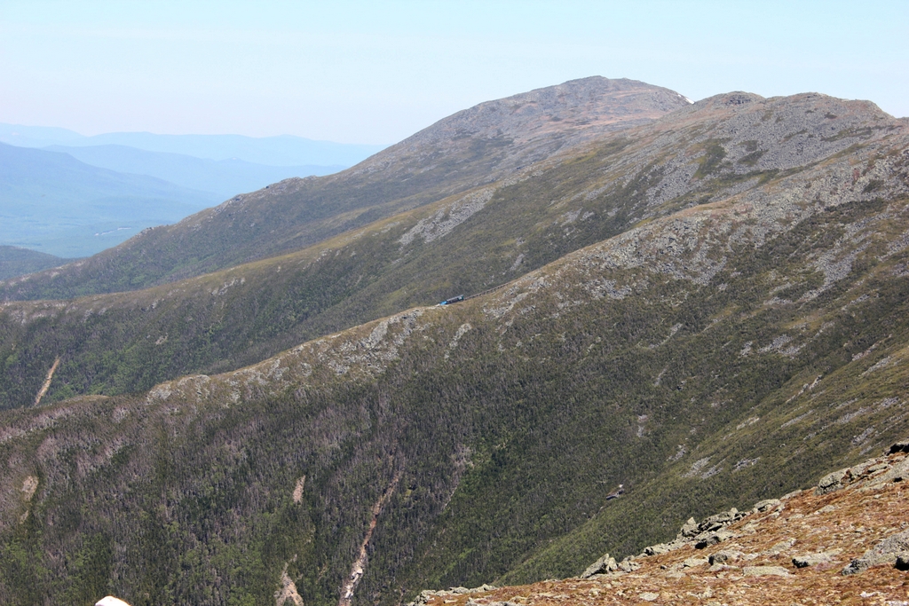
The first photo here was taken from the same spot, and perhaps even on the same day, as the one in the previous post. However, while that photo shows the summit of Mount Washington from Mount Monroe, this view looks a little further to the west, showing the western side of Mount Washington with Mount Jefferson further in the distance. As was the case with the previous post, I took the 2020 photo without having first seen the 1900 one. I took the photos during a hike along the southern Presidential Range from Crawford Notch to Mount Monroe, and later discovered that several of the photos lined up perfectly with ones that were taken around 1900 by the Detroit Publishing Company. In this particular view, perhaps the most remarkable similarity is that both photos show a Mount Washington Cog Railway train in the exact same location, right in the center of the photo.

The highest mountain visible in this scene is Mount Jefferson, which is a little over three miles away from here. At 5,712 feet, it is the third-highest peak in the northeastern United States, after the nearby Mount Washington and Mount Adams. Along with Mount Madison and Mount Monroe, these comprise the five highest peaks in the region, and they are named in honor of the first five presidents, with the elevation rank corresponding to the order in which they served as president. However, Madison and Monroe are very close in elevation, and subsequent surveys discovered that Monroe is actually slightly higher, despite being named for the fifth president.

Aside from Mount Jefferson, the most visible landscape feature here is Ammonoosuc Ravine, a large glacial cirque in the foreground that forms the western slope of Mount Washington. Further in the distance is Burt Ravine, a somewhat smaller cirque to the northwest of Mount Washington. In between these two ravines is a ridgeline that runs diagonally across this scene. The steep slopes of this ridge, combined with the heavy precipitation here, makes it prone to landslides, and both photos show the scars of large slides here on the southern side of the ridge.

Both photos also show the Mount Washington Cog Railway, which runs along this ridge between Ammonoosuc and Burt Ravines. Completed in 1869, this three-mile railroad was a major engineering feat, with trains rising about 3,500 feet in elevation from the base station to the summit. This was far too steep for conventional trains, so the railway’s founder, Sylvester Marsh, developed a rack-and-pinion system with a gear on the locomotive that engaged a rack in the center of the track. This allowed the gear to pull the train up the mountain, and then safely lower it in a controlled descent on the return trip.

The Mount Washington Cog Railway was the first of its kind in the world, and it today it is the world’s second-steepest railroad. The single steepest part of the route is a trestle known as Jacob’s ladder, with a maximum grade of more than 37%. This trestle is visible in the center of both photos, and coincidentally both photos show a train at the same spot at the base of the trestle. As was the case more than a century ago, the trains still climb and descend with the locomotive always on the downhill side of the train and a single passenger coach facing uphill. The only difference is the type of locomotive; for most of the railroad’s history it operated steam locomotives, but it now primarily uses biodiesel locomotives, which are more environmentally friendly and less expensive to run.

Overall, the type of locomotive on the trestle is essentially the only difference between these two photos. Although the summit of Mount Washington has been heavily developed with over the years with many buildings and other structures, the rest of the Presidential Range has remained largely unchanged, with few signs of human activity aside from hiking trails. Most of the range, along with much of the surrounding land, is now protected as part of the White Mountain National Forest, which was established in 1918 and has grown to over 750,000 acres of land in New Hampshire and Maine.

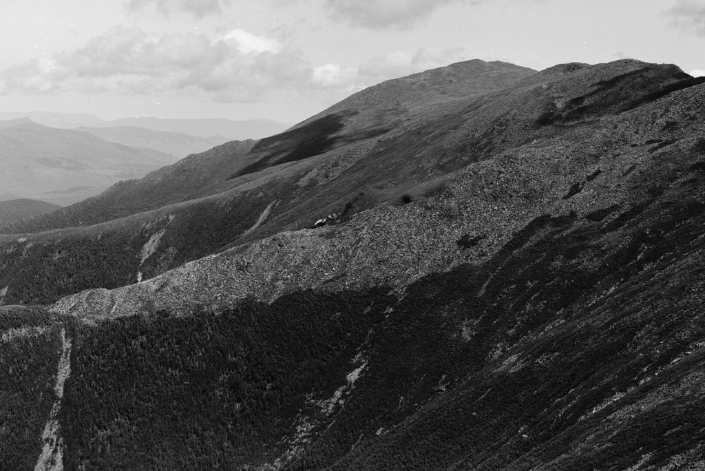
Mount Washington from Mount Monroe, New Hampshire

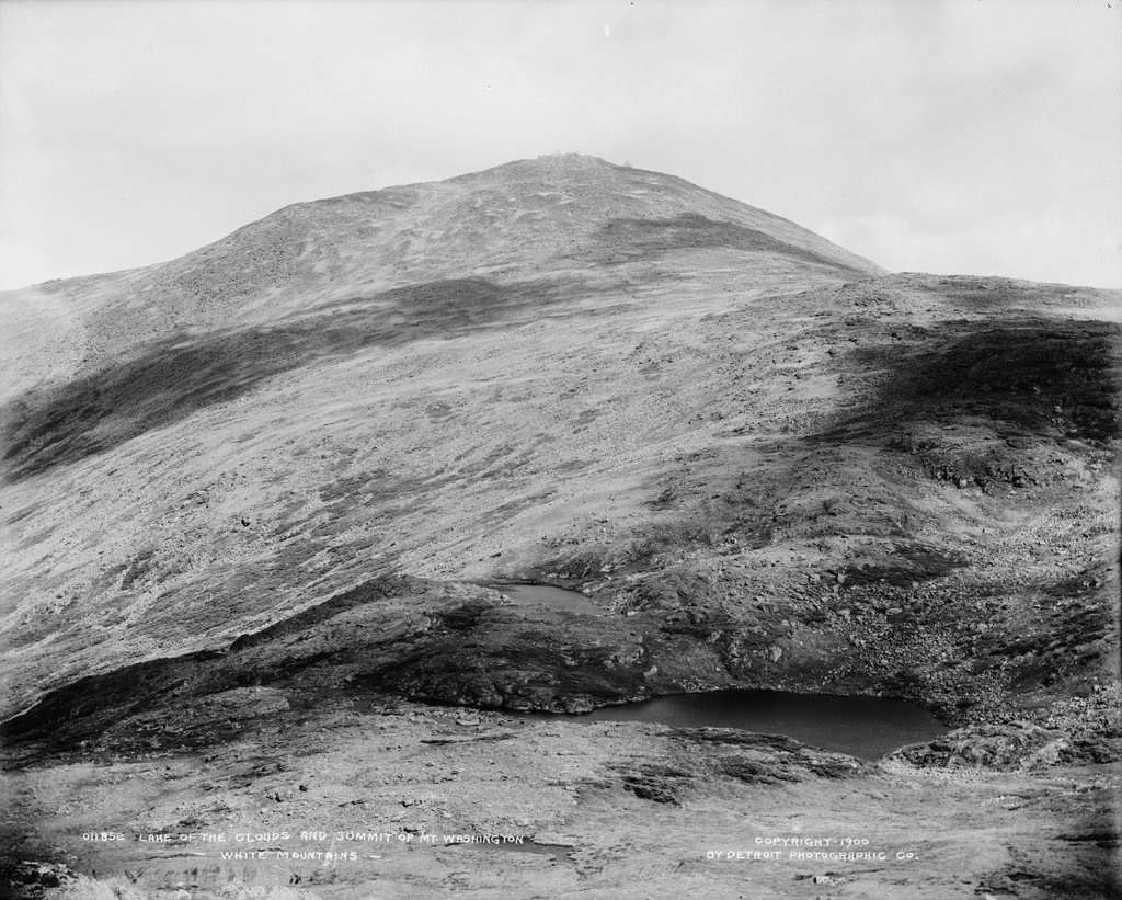
The summit of Mount Washington, seen looking north from Mount Monroe in the Presidential Range of the White Mountains, around 1900. Image courtesy of the Library of Congress, Detroit Publishing Company Collection.

The view in 2020:

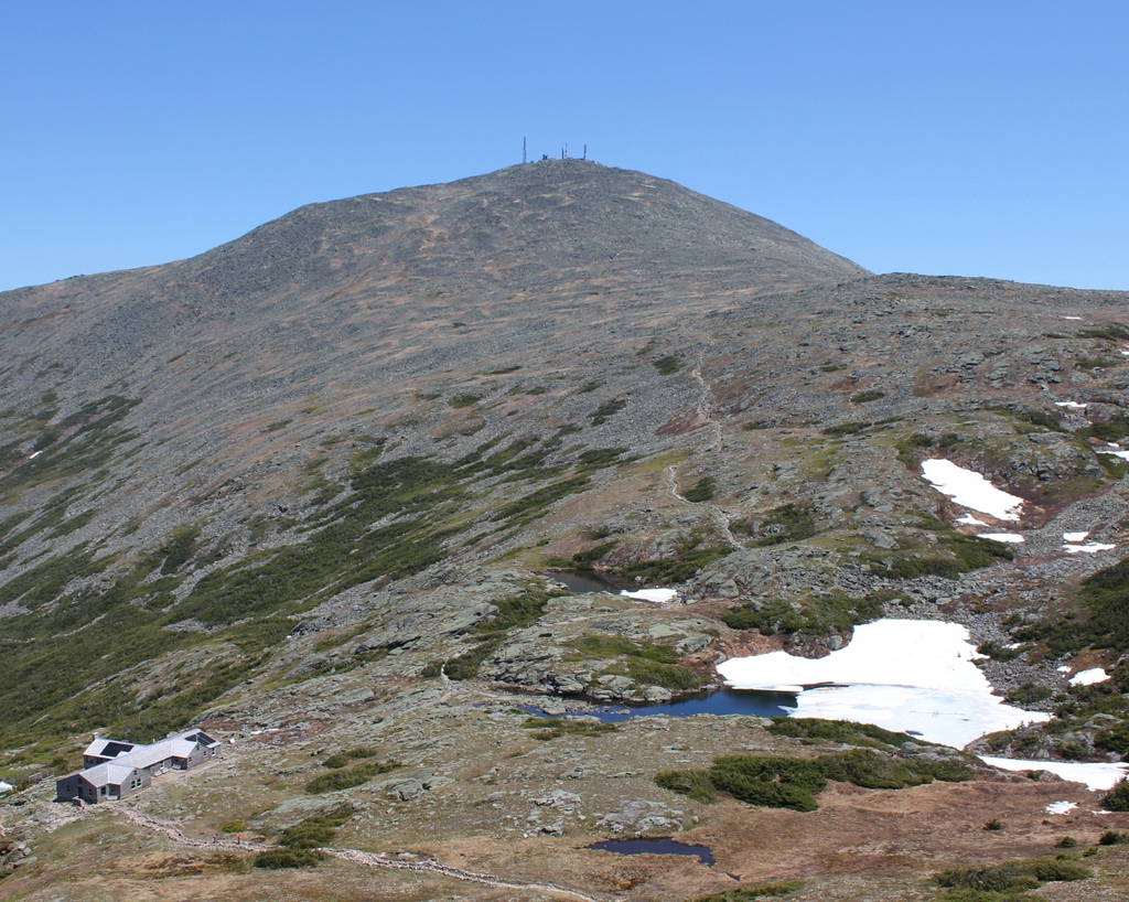
Rising 6,288 feet above sea level, Mount Washington is the highest peak in the northeastern United States. It stands at the center of the Presidential Range, a north-south oriented mountain range that forms a massive ridgeline of bare rocks and alpine vegetation. The range is infamous for its harsh and unpredictable weather, particularly at the summit of Mount Washington, which for many years held the world record for fastest surface wind speed ever recorded, at 231 miles per hour. Hypothermia is a year-round threat to hikers, and although there is no permanent ice cap, pockets of snow can linger well into the summer, as shown in the 2020 photo, which was taken on June 18.

Aside from Mount Washington, most of the other peaks in the range are also named for presidents. The five highest peaks are named after the first five presidents, in order of elevation, so that Mount Adams is the second-highest and Jefferson the third-highest. However, Mount Monroe, where these photos were taken from, is actually the fourth-highest, but it was named for the fifth president because of a surveying error. Monroe is the southernmost of these five major peaks; to the south are several lower peaks in the Presidential Range, including Mount Eisenhower and Mount Pierce.

Mount Washington’s high elevation and inhospitable climate have long attracted visitors to the summit. The first recorded ascent occurred in 1642, when Darby Field climbed the mountain accompanied by two Native American guides. Governor John Winthrop recorded the event in his diary, referring to the mountain as “the white hill,” since the mountain’s eventual namesake would not be born for another 90 years. Field’s exact route is uncertain, but he evidently approached it from the south, as Winthrop mentions two ponds along the way, which were likely the Lakes of the Clouds shown here in this scene. Aside from helping determine Field’s route, the mention of the lakes also helps to verify his ascent, since he would not have known about them unless he actually climbed at least this far.

The mountain was only occasionally climbed during the rest of the 17th and 18th centuries, but this began to change in the early 19th century. In 1819, local residents Abel and Ethan Allen Crawford cut an 8.5-mile path from Crawford Notch to the summit of Mount Washington, following the ridgeline of the southern Presidential Range. The trail passed through this scene just to the East of the summit of Mount Monroe, and most of it is still in use today as part of the Appalachian Trail, making it the oldest continuously-maintained hiking trail in the country. Ethan Allen Crawford built a cabin, and later a hotel, at the base of the trail, and he also acted as a guide for hiking groups setting out from Crawford Notch. The Crawford family later improved the trail for use as a bridle path, and by the 1840s visitors could ride to the top of the mountain on horseback.

The first building at the summit was a small hotel that opened in 1852. It was joined a year later by the rival Tip Top House, which still stands atop the mountain today. At the time, the only ways to get to the top were by foot or by horseback, but this would soon change. The Mount Washington Carriage Road opened in 1861, bringing visitors up the east side of the mountain, and the Mount Washington Cog Railway followed eight years later on the western slopes of the mountain. These two routes helped to spur more development, and by the time the first photo was taken around 1900 the summit was crowded with buildings, including the Tip Top House, a weather observatory, and the massive Summit House hotel, which could accommodate 150 guests. The summit even had its own daily newspaper, Among the Clouds, which was published during the summer months from 1877 to 1917.

By the late 19th century it was easier than ever to reach the summit, but many visitors chose to test their abilities by hiking up the mountain. However, because of the mountain’s notorious and often unpredictable weather, this sometimes led to tragic consequences for unprepared or unlucky hikers. The first known fatality in the Presidential Range was Frederick Strickland, who began his hike on October 19, 1849, when the mountain was already covered in deep snow. He climbed via the Crawford Notch, and he would have passed through this scene on his way up the mountain. Strickland made it to the top, becoming the first known hiker to do so in winter conditions, but he ultimately succumbed to hypothermia while descending the western side of the mountain. His body was discovered well below the tree line, near where the present-day Jewell Trail crosses Clay Brook.

One of the most famous tragedies on the mountain occurred on June 30, 1900, when William Buckingham Curtis and Alan Ormsbee both died of hypothermia while ascending the mountain. Both men were experienced outdoorsmen, and Curtis was renowned as an athlete and promoter of amateur athletics. As with Frederick Strickland a half century earlier, they hiked up the Crawford Path from Crawford Notch. Their goal was to attend the Appalachian Mountain Club meeting at the summit, but they faced harsh conditions along the way, including dense fog, sleet, and high winds. They climbed to the summit of Pleasant Dome (now Mount Eisenhower), and they were last seen alive soon after by a descending group that warned them of the deteriorating conditions ahead.

The first photo was probably taken within a year or two of Curtis’s and Ormsbee’s deaths, and it shows the section of the mountain where their journey came to an end. It is unclear as to whether they took the Crawford Path to the east of Mount Monroe, or if they took  the loop trail over the summit, but just to the north of Monroe they took shelter in a dense stand of stunted spruce trees. For unknown reasons, they subsequently left this shelter, and Curtis’s body was discovered a short distance beyond the trees, somewhere near the foreground on the far right side of these two photos. Ormsbee managed to continue up the mountain, but he ultimately died just a few hundred feet short of the summit.

In the aftermath of this tragedy, the Appalachian Mountain Club built a small shelter here in the area between Mount Monroe and Mount Washington, near the spot where Curtis died. It was completed in 1901, and was large enough for about six to eight people, yet uncomfortable enough to discourage use for anything other than an emergency situation. However, hikers nonetheless used the shelter for regular camping, and in 1915 it was replaced by the Lakes of the Clouds Hut, which was built a little lower on the slope on the far left side of the scene. Far more than just serving as an emergency shelter, this hit was staffed by the AMC, and provided overnight accommodations along with meals for hikers.

Today, around 120 years after the first photo was taken, Mount Washington remains a popular destination, accessible either by train, by car, or by foot. The Lakes of the Clouds Hut has been expanded several times over the years, and it now has bunk space for 90 hikers. The hut is located at the convergence of several major trails, including the Crawford Path, which still follows essentially the same route that the Crawford family laid out more than two centuries ago. The only significant change to the path is here between Mount Monroe and Mount Washington, where it was rerouted to access the hut, and to eliminate unnecessary switchbacks.

Overall, this scene has changed very little since the first photo was taken, aside from the construction of the hut. The surrounding land is now protected as part of the 750,000-acre White Mountain National Forest, which was established in 1918. The Presidential Range is a particularly important part of this national forest, as it features a number of rare alpine plants, including the Robbins’ cinquefoil, an extremely rare flower that can only be found here on the slopes of Mount Monroe. Because of the fragile nature of many of these plant species, combined with the thousands of people who climb Mount Washington each year, one of the present-day challenges here is balancing conservation with recreation in order to ensure that this view continues to remain unchanged for the next 120 years and beyond.

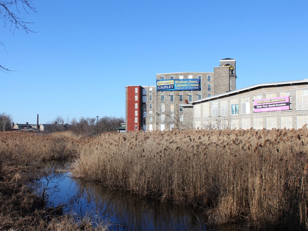
Barnard Mills, Fall River, Mass

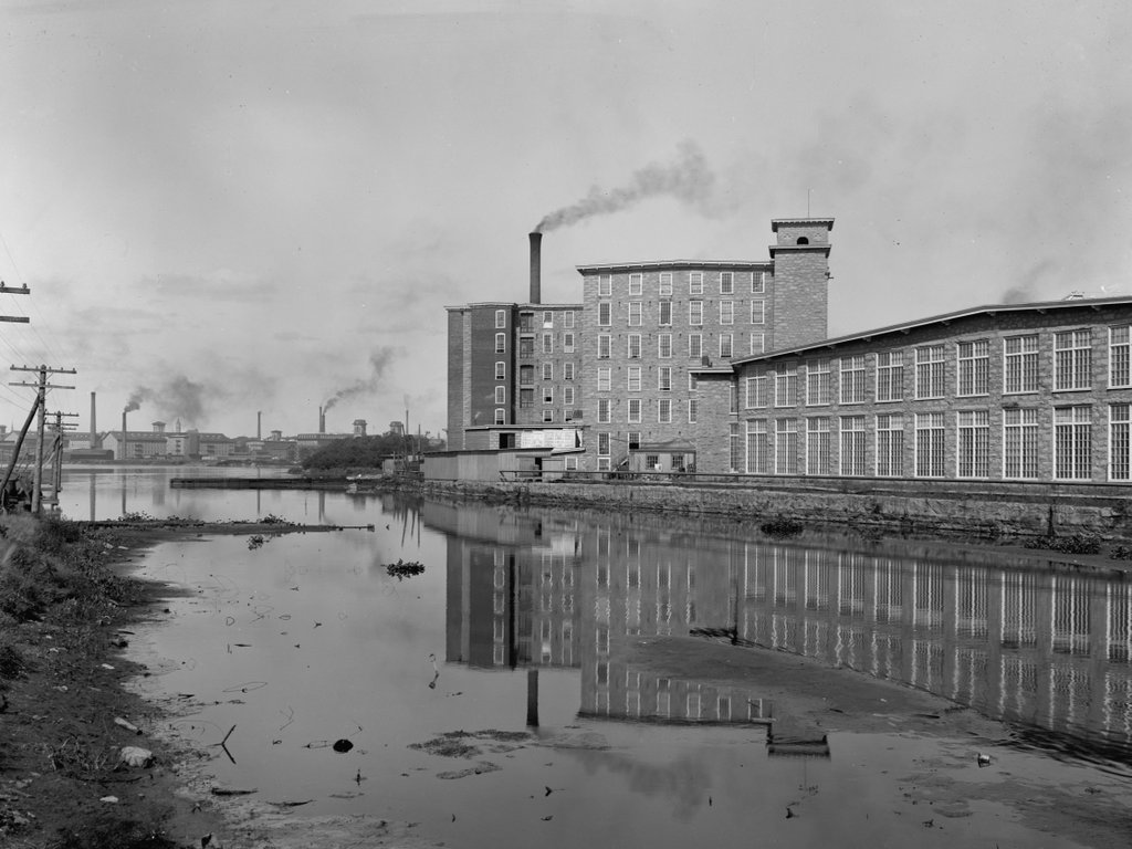
The Barnard Mills from across the Quequechan River in Fall River, around 1910-1920. Image courtesy of the Library of Congress, Detroit Publishing Company Collection.

The scene in 2020:

The city of Fall River owes both its name and its 19th century population boom to the Quequechan River, which flows westward through the center of the city and into Mount Hope Bay. Along the way, the river drops about 130 feet in elevation as it passes through the city, making it ideal as a source of water power. During the 19th century, this led to the establishment of many different textile mills along the river, to the point where the river’s capacity had essentially reached its limit by mid-century. However, by this point Fall River was well-established as an important textile center, and more mills continued to open here, many using coal as an energy source rather than water power.

Fall River’s largest textile boom came in the post-Civil War era, when over a dozen new companies opened in the city. Among these was the Barnard Manufacturing Company, which was incorporated in 1872. This was not a particularly auspicious time to start a large corporation, given the impending economic recession caused by the Panic of 1873, but it was during this time that the company built this mill complex on the north side of the Quequechan River, just west of Quarry Street. The main building, a large five-story mill with a tower on the side, was completed in 1875, and like many of the other Fall River mills, it was constructed of locally-quarried granite.

Upon completion, the Barnard Mills had 28,400 spindles, 768 looms, and it could produce around nine million yards of print cloth each year. The company was named for its president, Louis L. Barnard, who was also involved in the Sagamore Mills elsewhere in Fall River. The first treasurer of the Barnard Mills was Nathaniel B. Borden, who came from a prominent local family. His father, also named Nathaniel, had been a mayor and Congressman, and his uncle Simeon was a land surveyor known for his work on the early 1830s trigonometrical survey of Massachusetts. However, he does not appear to be closely related to the most famous Borden in Fall River, Lizzie Borden, who would have been a teenager when this mill opened.

The facility was subsequently expanded in 1896, with the construction of a two-story weave shed to the southeast of the original mill. This new building increased the capacity of the mill to 66,480 spindles and 4,769 looms, and by this point the company employed 500 people. The first photo was taken a couple decades later, showing the original 1875 building in the distant center, with the 1896 weave shed in front and to the right of it. In the foreground is the Quequechan River, and further downstream in the distance on the far left side are a few other textile mills. These buildings feature similar architecture to the Barnard Mills, and they are likewise built of local granite.

Fall River’s textile industry was still prospering when the first photo was taken, but it entered a steep decline in the 1920s. Many companies moved to the south during this decade, and the remaining ones were hurt by the Great Depression, which followed the 1929 stock market crash. The Barnard Mills ultimately survived longer than most, closing in 1939.

Today, Fall River is far removed from its heyday as a textile manufacturing center, but many of the historic mill buildings are still standing, and have been repurposed for other uses. Here at the Barnard Mills, the buildings have been converted into commercial and retail use. The complex is now known as the Tower Mill, and its tenants include a Planet Fitness gym, a building supply outlet, and a party dress shop, as shown by the large advertisements on the building. Aside from these signs, though, the buildings have retained much of their historic exterior appearance, and many of the other mills in the distance are also still standing. Perhaps the most significant change to this scene is the river itself, which is now a narrow stream that winds its way through the reeds in what had once been the millpond.

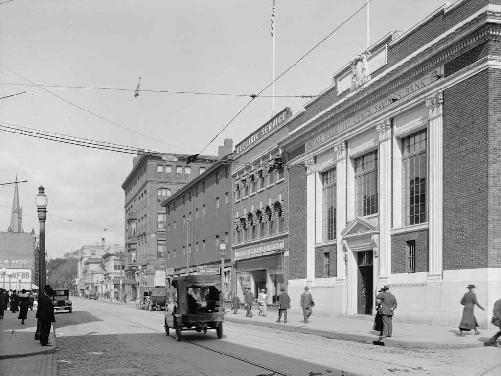
North Main Street, Fall River, Mass

Looking north on North Main Street from the corner of Bank Street in Fall River, around 1914-1920. Image courtesy of the Library of Congress, Detroit Publishing Company Collection.

The scene in 2020:

Throughout the 19th century, Fall River was a prosperous textile manufacturing center. The city saw dramatic population growth during this time, particularly in the post-Civil War period. Between 1860 and 1900, the city grew nearly eightfold, from 14,000 to nearly 105,000, and by the turn of the century it was the third-largest city in Massachusetts, behind only Boston and Worcester.

However, the same textile industry that had brought such prosperity also led to the city’s decline, as mills closed and businesses relocated to the south starting in the 1920s. This, combined with a catastrophic fire that destroyed much of the downtown area in 1928, both hurt the local economy, and these problems were only exacerbated by the stock market crash at the end of the decade.

The first photo was taken in the final years of the textile industry’s heyday in Fall River, probably sometime between 1914 and 1920. The earliest possible date is 1914, when the Fall River Five Cents Savings Bank building was built on the far right side of the scene, at the corner of North Main and Bank Streets. The neighboring building to the left of it was also built in 1914, and in the first photo it was occupied by the Fall River Electric Light Company.

Just beyond the electric company building is the Mount Hope Block, which was perhaps the oldest building in the first photo. It was built in 1845, in the aftermath of a large fire two years earlier, and it was originally known as the Mount Hope House. At the time, it was one of two hotels in Fall River, and in 1847 a state gazetteer declared that “in the erection and furnishing no pains have been spared to make it a desirable place for any one disposed to spend a few days.” Later in the 19th century it was known as the Narragansett Hotel, and by the early 20th century it was the Evans House. The building initially occupied the entire length of the block between Bank and Franklin Streets, but the southern portion was demolished to build the bank and the electric company buildings, leaving only the northern half as shown in the first photo.

Beyond the Mount Hope Block, on the other side of Franklin Street, the largest building in the first photo is the Hotel Mellen. It opened in 1888, and was the city’s finest hotel throughout the first half of the 20th century. The building survived the 1928 fire, but it was subsequently gutted by a fire in 1943, leaving only the brick walls still standing. The hotel was rebuilt inside the brick shell of the old building, although the new one was six stories in height, rather than five.

Today, more than a century after the first photo was taken, there is very little that survives from the first photo, especially in the foreground. The bank is still standing at the corner, but the former electric company building and the Mount Hope Block are both gone. Both of these buildings were here when the Downtown Fall River Historic District was created in 1983, but they were demolished at some point after that, and the site is now occupied by a large wing of the bank building. This facility still serves as the main offices of the Fall River Five Cents Savings Bank, which is now branded as BankFive.

Further in the distance, the reconstructed Hotel Mellen is also gone. The hotel closed around the early 1960s, and the building was converted into a temporary city hall after the old city hall building was demolished to build Interstate 195. The current Brutalist-style city hall was completed in 1976, and the old hotel was then demolished soon after. Beyond the Hotel Mellen, there are several surviving buildings from the first photo, but for the most part this side of North Main Street has undergone signficiant changes, unlike the right-hand side of the street, which has been better-preserved over the years.

First Congregational Church, Fall River, Mass

The First Congregational Church, seen looking up Cherry Street from the corner of June Street, around 1913-1920. Image courtesy of the Library of Congress, Detroit Publishing Company Collection.

The church in 2020:

The First Congregational Church of Fall River was established in 1816, and throughout most of the 19th century the church worshipped in a building at the northwest corner of North Main and Elm Streets. However, in 1913 the church moved into this new building, which was donated by one of its parishioners, Sarah S. Brayton. The building was designed by the prominent Boston architectural firm of Shepley, Rutan & Coolidge, and it features a granite, Gothic Revival exterior. It was formally dedicated on January 9, 1913, on the 97th anniversary of the church’s founding. Among those in attendance was Sarah Brayton, who was 78 years old at the time, and the dedication sermon was delivered by the Rev. Nehemiah Boynton of the Clinton Avenue Congregational Church in Brooklyn.

The first photo was taken within a few years after the building was completed. It is a rather strange angle, because it shows the rear and side of the church, with the parish house in the foreground on the left. Further up in the distance, on the other side of Rock Street, is the B.M.C. Durfee High School, which was built in 1886. The three girls on the sidewalk are likely students at the school, and are apparently walking home at the end of the school day. During the early 20th century, the Durfee High School ended at 1:25 p.m., and the photo was taken ten minutes later at 1:35, according to the school’s clock tower.

Today, more than a century after the first photo was taken, almost nothing has changed in this scene except for the trees, which now partially hide the buildings. The church is still an active congregation, and the exterior of the building has remained well-preserved. Further up the hill, the old high school building was converted into a family and probate courthouse in the 1990s, but it has retained its historic exterior appearance. The high school building was added to the National Register of Historic Places in 1981, and two years later both it and the church were designated as contributing properties in the Highlands Historic District.

Rock Street from Pine Street, Fall River, Mass

Looking north on Rock Street from the corner of Pine Street in Fall River, around 1913-1920. Image courtesy of the Library of Congress, Detroit Publishing Company Collection.

The scene in 2020:

The first photo shows a street scene in Fall River with an interesting assortment of commercial storefronts, single-family homes, and multi-family homes, along with a church and a school. The buildings also vary widely in age; some date back to the 1840s, while others were built just a few years before the photo was taken. Remarkably, though, all of the buildings from the first photo are still standing today, and this scene does not look substantially different from its appearance more than a century ago.

The city of Fall River developed into a major textile manufacturing center during the early 19th century, and some of the oldest buildings in this scene were built during that time. In the distance, on the left side of the street, is a group of four houses, located at 222, 232, 242, and 254 Rock Street. The oldest of these, number 222, is hidden from view by the building in the foreground, but it was built around 1815. Just beyond it, and also hidden here, is number 232, built around 1848. Both of these buildings have had significant exterior alterations, but the two that are visible in the distance of this scene, at 242 and 254 Rock Street, were built in the mid-1840s and have remained well-preserved over the years. In particular, 254 Rock Street survives as an excellent example of Carpenter Gothic architecture.

On the right side of the street, the oldest building here is at 223 Rock Street, which is the three-story building just beneath the clock tower. It was built around 1845, but it was originally located at 151 Rock Street. It was moved to its current location in 1913, so its presence here in the first photo establishes the earliest possible date for the photo.

Closer to the foreground, on the far right side of the scene, is 201-203 Rock Street. It was built around 1861, and its original owner was Albert Winslow, a former New Bedford whaling ship captain who retired to Fall River. According to the 1861 city directory he ran a grocery store here at the house, presumably in the basement storefront, and the 1870 census shows him living here with his wife Permela, their five children, and his sister Rowena. By 1900 both Albert and Permela were still living here, as were their three daughters: Hope, Amelia, and Ella. Permela died in 1902, and Albert in 1908, but the three sisters were still here when the first photo was taken. They evidently rented a portion of the house, because both the 1910 and 1920 censuses show a second family living here.

Until the late 19th century, this section of Rock Street primarily consisted of small wood-frame houses. However, in 1886 the city constructed the B.M.C. Durfee High School a block to the north of here. Most of the building is hidden from view in this scene, but its prominent clock tower is visible in the distance on the right side of the photos.  Another major addition to this scene is the First Congregational Church, which stands opposite the high school building in the distance on the left side of Rock Street. The church was designed by the prominent architectural firm of Shepley, Rutan & Coolidge, and it was dedicated in January 1913, probably only a few years before the first photo was taken. Aside from the school and church, the other new building in the first photo was the Gee Building, the two-story commercial building in the foreground on the left side. It was built in 1910, at the northeast corner of Rock and Pine Streets.

Today, more than a century after the first photo was taken, some of the buildings here have undergone changes, but overall this section of Rock Street remains well-preserved. In the foreground, probably the most visible difference is the ground floor of the Gee Building, which has been completely altered from its early 20th century appearance. The storefront on the Winslow house across the street has also changed, but not to the same extent. Further in the distance, both the church and the high school are still standing, although the high school has since been converted into a probate and family courthouse. The only building in this scene that was constructed after the first photo was taken is the house in the distance at 253-255 Rock Street, which was built in 1923. Because of their preservation and historic significance, all of the buildings on this block of Rock Street are now part of the Lower Highlands Historic District, which was added to the National Register of Historic Places in 1984.