High Street from Division Street, Holyoke, Mass

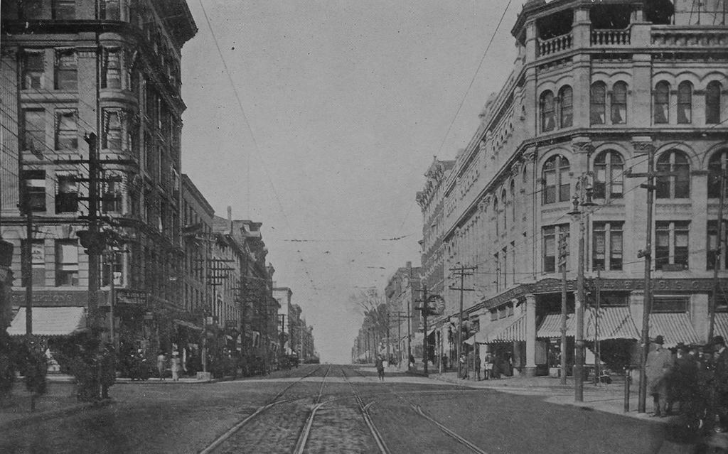
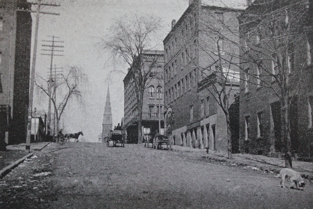
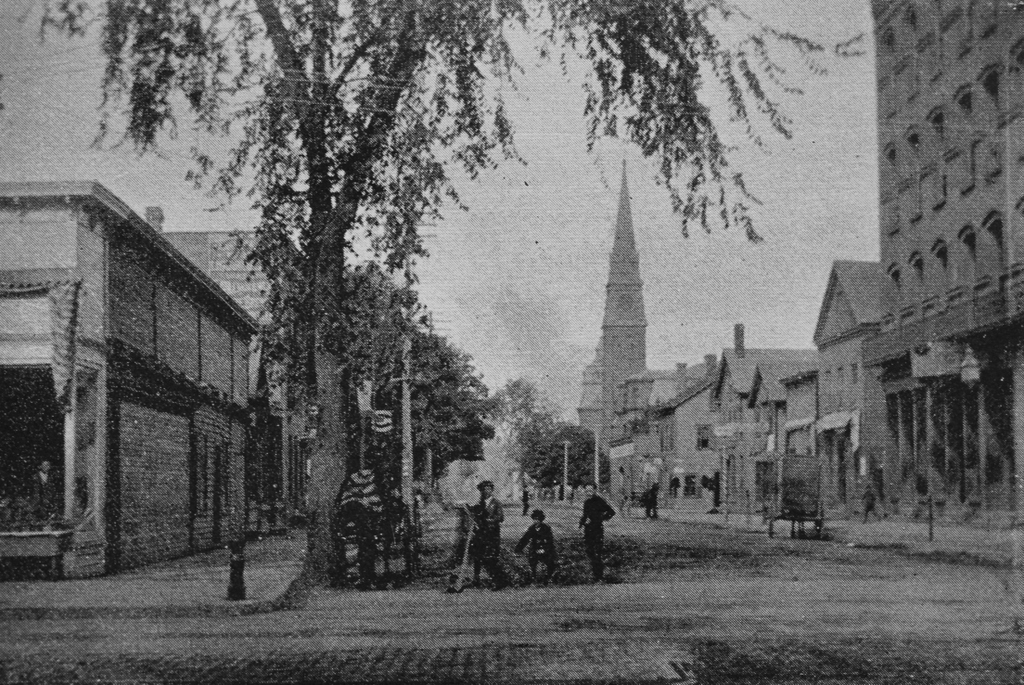
Looking north on High Street from the corner of Division Street in Holyoke, around 1910-1915. Image from Illustrated & Descriptive Holyoke Massachusetts.
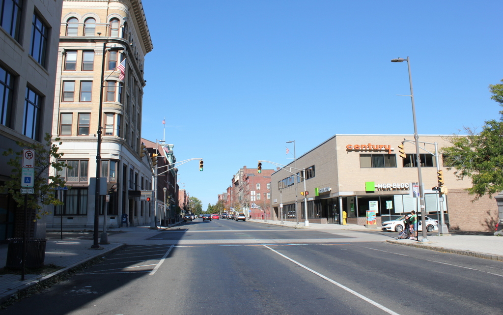
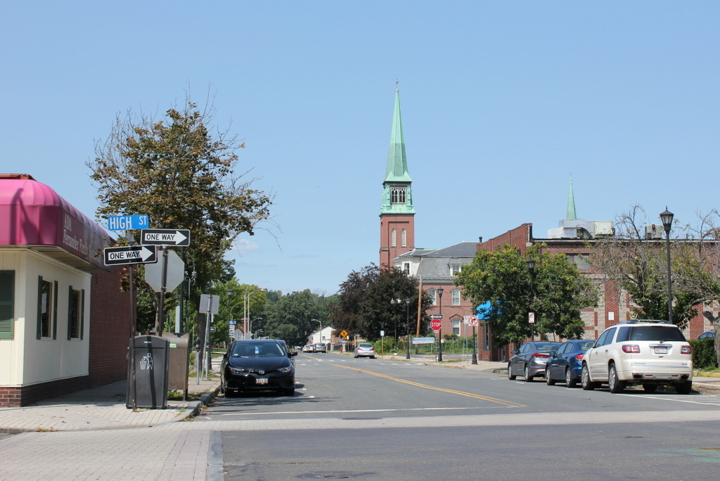
The scene in 2017:

High Street has been the commercial center of Holyoke since the second half of the 19th century, and it is still lined with a number of historic buildings that date back to this period. This particular block, looking north from Division Street toward Suffolk Street, has not remained as well-preserved as some of the blocks to the north, as shown by the differences between these two photos. However, there are still some surviving buildings from the first photo, particularly in the foreground on the right side.

Starting on the far right, closest to the foreground, is the Guyott House, a hotel that was built in the mid-1880s and was operated by brothers Theodore and Victor Guyott. It occupies a corner lot, and features a small tower that projects slightly above the roofline and outward from the walls. Just to the left of it is a four-story building with an ornate brownstone facade. Built in 1892, it was also owned by the Guyott brothers, and was evidently used as part of the hotel at some point. Although these two buildings have very different exterior designs, they both feature Romanesque-style architecture, and both were designed by noted Holyoke architect George P. B. Alderman.

Further in the distance is a four-story, brick building at 320-322 High Street. It was probably built around the same time as its neighbors to the right, although its architect appears to be unknown. On the left side of this building, in the first photo, is the old central fire station, which was completed in 1864. It was probably the oldest building visible in the first photo, and served as the city’s first central fire station until around 1915, when a new fire station was built on Maple Street. This new building is still standing as the Holyoke Transportation Center, but the old one was demolished soon after the first photo was taken, and the present six-story Young Men’s Hebrew Building was constructed on the site.

Several other buildings on the right side have also since been demolished, including the Cunningham Building, which once stood at the corner of Suffolk Street on the other side of the fire station. However, the left side of the scene has undergone more drastic changes in the century since the first photo was taken. The small two-story building, constructed sometime in the early 1910s, appears to still be there, but not much is left from the 19th century. Perhaps the only relatively unaltered 19th century building along this section of High Street is the Conway Block, which was built around 1885 and still stands in the distance on the southwest corner of Suffolk Street.

High Street from near Dwight Street, Holyoke, Mass

Looking north on High Street, from just south of the corner of Dwight Street in Holyoke, around 1910-1915. Image from Illustrated & Descriptive Holyoke Massachusetts.

The scene in 2017:

The first photo shows the commercial center of Holyoke during the early 20th century, when the city was at the height of its prosperity. Both sides of High Street were lined with commercial buildings, most of which had been built in the second half of the 19th century. They represented a range of architectural styles, and two of the most significant buildings stood in the foreground at the corner of Dwight Street. On the left is the six-story Ball Block, which was built in 1898, and on the right side of the first photo is Delaney’s Marble Block, which was built in 1885 and was designed by noted local architect James A. Clough.

Today, more than a hundred years after the first photo was taken, Holyoke has undergone some significant changes. Much of its manufacturing base was gone by the mid-20th century, and the city has since experienced rising poverty rates and declining population. However, this economic stagnation may have also helped to preserve many of the historic commercial blocks on High Street, since there has been little demand for new developments. Almost all of the buildings are still standing from the first photo, and the only noticeable loss is Delaney’s Marble Block, which was demolished around 1950 to build the present-day two-story building. The buildings in this scene are now part of the North High Street Historic District, which was added to the National Register of Historic Places in 1986.

Main Street, Holyoke, Mass

Looking north on Main Street from near the corner of Dwight Street in Holyoke, around 1891. Image from Holyoke Illustrated (1891).

The scene in 2017:

The first photo shows a row of late 19th century buildings along the east side of Main Street, looking north from near Dwight Street, toward Mosher Street. The buildings represent a mix of architectural styles, but the one that stands out the most is the large, highly ornate Romanesque-style Whiting Street Building in the center of the photo. It was built in 1885 at 32 Main Street, and was owned by the estate of Whiting Street, a prominent Northampton philanthropist who had died a few years earlier in 1878. Around the same time, he also became the namesake of the Whiting Street Reservoir, which opened at the base of Mount Tom in 1888, on land that Street had once owned.

One of the early tenants of the Whiting Street Building was the American Pad and Paper Company, which had been established here in Holyoke in 1888 by Thomas W. Holley. The company, which later came to be known as Ampad, built its business around purchasing scraps from the city’s many paper mills, which were then bound into notebooks and sold at competitive prices. In the process, Holley is said to have invented the first legal pad, a development that, if true, likely would have occurred here in this building.

Early on, American Pad and Paper occupied three rooms here at 32 Main Street, and eventually expanded to eight rooms. The company was here when the first photo was taken in the early 1890s, but around 1895 it moved into a building of its own, at the corner of Appleton and Winter Streets. Over the years, Ampad would go on to become a major producer of pads and other office supplies, and it ultimately outlived nearly all of Holyoke’s other paper mills. The company is still in business today, although not in Holyoke. It is now headquartered in Texas, and it closed its last Holyoke facility in 2005.

In the meantime, this building here on Main Street was subsequently occupied by another writing pad company, the Whiting Street Ruling and Stationery Company. Around 1901, it was renamed the Affleck Ruling and Stationery Company, and was described in a 1905 advertisement in the city directory as “Manufacturers Paper, Pads and Tablets, Paper Rulers and Printers. Mourning Cards and Fine Cards for Engravers.” The company remained here until around 1907, but by the following year it had moved to a new location at 18 North Bridge Street.

Today, more than 125 years after the first photo was taken, none of the buildings from that scene are still standing. The one on the far right was likely the first to go, and was replaced by the present-day building at some point during the early or mid-20th century. Most of the other buildings survived until at least the 1970s, although the Whiting Street Building was destroyed in a fire in 1977. The ones further in the distance were still standing a year later, when they were inventoried as part of the state’s MACRIS database of historic resources, but they have since been demolished, leaving only vacant lots where they once stood.

Main Street near Court Street, Springfield, Mass

The east side of Main Street, looking toward the corner of Court Street in Springfield, around 1938-1939. Image courtesy of the Springfield Preservation Trust.

The scene in 2017:

The first photo shows a group of four buildings along the east side of Main Street, representing a wide range of late 19th and early 20th century architectural styles. On the left side is the ornate Beaux Arts-style Union Trust Company building, which was completed in 1907. It was designed by the noted architectural firm of prominent Boston-based architectural firm of Peabody & Stearns, and housed the Union Trust Company. This company was formed by the 1906 merger of three city banks, and it still occupied the building when the first photo was taken in the late 1930s.

Just to the right of the Union Trust Company, in the center of the first photo, is a five-story Second Empire-style building that once housed the Massachusetts Mutual Life Insurance Company. The company was originally located in the Foot Block, at the corner of Main and State Streets, from 1851 to 1868, before moving into this building. However, its offices were only here for about five years before the building was gutted by a fire on February 5, 1873, although it was soon reconstructed based on plans by architect George Hathorne. The company would remain here until 1908, when a new, larger office building was completed a block south of here, where the Foot Block had previously stood.

The third building to the right was probably built sometime in the early 20th century, based on its architectural style. By the time the first photo was taken, the ground floor of this five-story building housed the Woman’s Shop, which offered “Distinctive Outer Apparel,” according to the sign above the entrance. To the right of it, at the corner of East Court Street (now Bruce Landon Way), is the Springfield Five Cents Savings Bank. It was built in 1876, and featured an ornate Main Street facade, including cast iron columns. A better view of the exterior can be seen in an earlier post, which shows the view of this scene from the opposite direction.

Today, almost 80 years after the first photo was taken, most of the buildings are still standing. The former Woman’s Shop building has remained relatively unaltered except for the exterior of the second floor, and the Union Trust Company building is now listed on the National Register of Historic Places because of its architectural significance. Even the Five Cents Savings Bank building is still there in the distance, although it is hard to tell from this angle. The Main Street facade was rebuilt in the mid-20th century, but the building itself remains standing, with the original southern facade visible along Bruce Landon Way. Overall, the only building from the first photo that is completely gone is the former MassMutual headquarters, which was demolished sometime around the 1950s and replaced with the current Modernist building.

Hampden Street near High Street, Holyoke, Mass

Looking northwest up Hampden Street, toward High Street in Holyoke, around 1892. Image from Picturesque Hampden (1892).

The scene in 2017:

These two photos show Hampden Street, just down the hill from where the photos in the previous post were taken. However, while the other post shows the view looking straight down the street, this view provides a better look at the buildings on the north side of Hampden Street. On the far right side of the first photo is one of the many tenement houses that were built in this area for the workers of the Lyman Mills. Just to the left of it, the building at the corner of High Street was built around the early 1860s by W. L. Martin, a coal, wood, and flour dealer who had his store here in the building. On the other side of High Street is a similar four-story brick commercial block, probably dating to the 1860s or early 1870s, and further in the distance is the tower of St. Jerome’s Church, located at the corner of Chestnut Street. The first photo also shows some of the traffic on the streets, with several horse-drawn carriages near the top of the hill and a stray dog in the foreground on the right.

Today, about 125 years later, this scene is still recognizable from the first photo, although several of the buildings are gone. The building on the right, along with the rest of the Lyman Mills tenements, was demolished in the late 1930s as part of an early urban renewal project. The bricks were saved, though, and were incorporated into the apartments that now occupy the site. The building on the other side of High Street is also gone, and the site is now a surface parking lot. However, the W. L. Martin Block is still standing, without many exterior changes from this angle. In the background, St. Jerome’s Church is also still there, although most of the interior had to be reconstructed after a major fire in 1934. Both the church and the Martin Block are now contributing properties in two different historic districts on the National Register of Historic Places, with the church in the Hampden Park Historic District, and the Martin Block in the North High Street Historic District.

Hampden Street from High Street, Holyoke, Mass

Looking northwest on Hampden Street from the corner of High Street in Holyoke, around 1892. Image from Picturesque Hampden (1892).

The scene in 2017:

The first photo shows downtown Holyoke during the height of the city’s prosperity. At the time, Holyoke included a number of factories along its extensive canal system, and it was a leading producer of paper and textiles. Further up the hill was High Street, which was the main commercial center of the city. It was part of the city’s street grid – a rarity among New England’s otherwise largely unplanned cities and towns – and was intersected by cross-town streets that led further up the hill to the residential neighborhoods. The names of these streets alternated between those of prominent early industrialists (Lyman, Dwight, Appleton, etc.) and those of Massachusetts counties (Suffolk, Essex, Hampshire, etc.).

Hampden Street, shown here in these two photos, was named for Holyoke’s own county, and, perhaps not coincidentally, is the longest of all these county streets, extending all the way up the hill to Easthampton Road. Here in the center of Holyoke, probably the most notable landmark along the street is St. Jerome’s Church, which stands at the corner of Chestnut Street, near the center of both photos. It was built in 1858, in the early years of Holyoke’s development, and it was the first of many Roman Catholic churches that would be built in the city, in order to serve the predominantly Catholic immigrants who worked in the factories. By the time the first photo was taken, the area around the church included a number of other parish buildings, including the Second Empire-style rectory, which is visible in front of the church.

Today, around 125 years after the first photo was taken, Holyoke has undergone some significant changes, most notably the loss of most of its industrial base in the mid-20th century. Much of the downtown area has remained remarkably well-preserved, but this particular scene along Hampden Street is the exception. The brick commercial block on the far right is gone, as are all of the other buildings in the foreground on the right side. On the other side of the street, the one-story building on the far left could plausibly be the same one from the first photo, but if so it has been altered beyond recognition. Otherwise, nothing is still standing from the left side, and the only surviving buildings from the first photo are the church and rectory in the distance.