Converse Street, Longmeadow, Mass

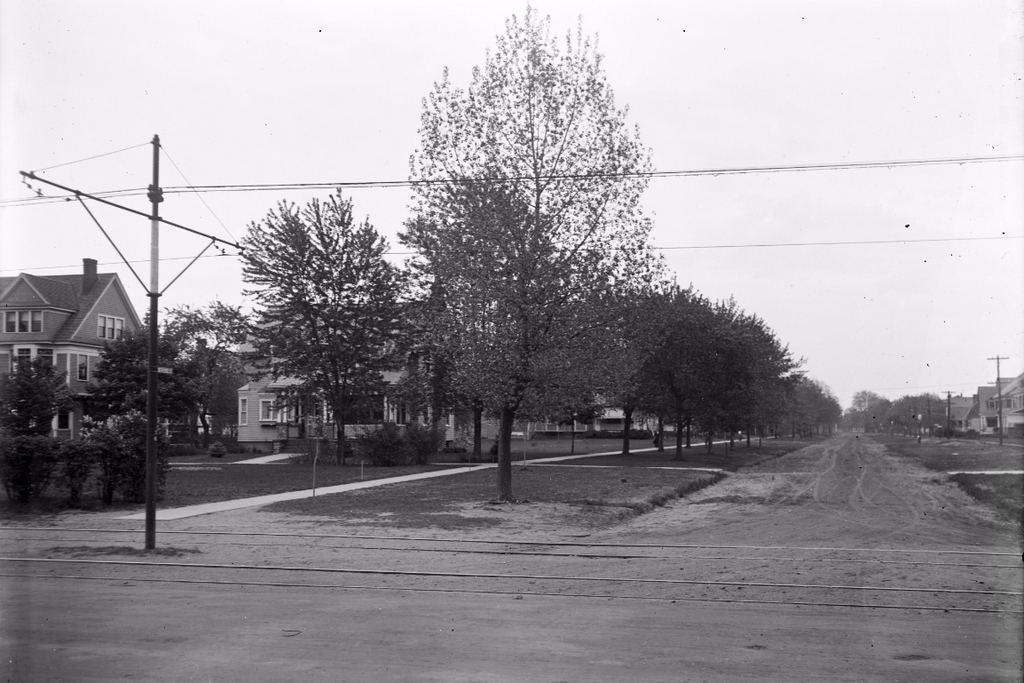
Looking east on Converse Street from the corner of Longmeadow Street, on May 13, 1913. Image courtesy of the Longmeadow Historical Society, Emerson Collection.

954_1913-05-13 longhs

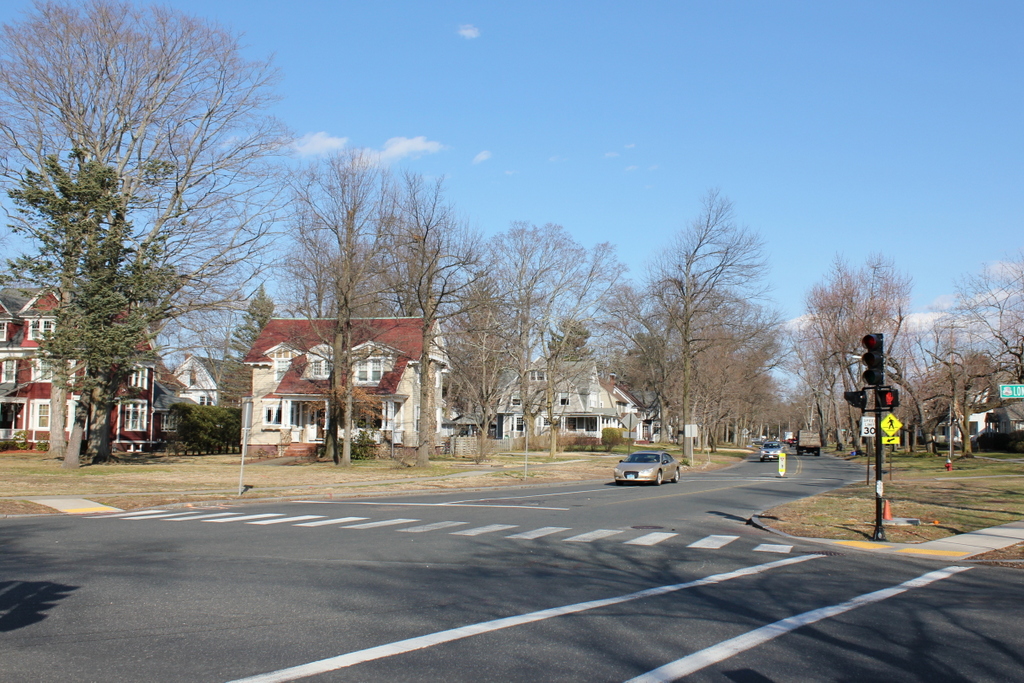
The view in 2016:

954_2016
The two photos on the left are the same ones seen in the previous post, and this view shows some of the development along the western end of Converse Street that was happening in the 1910s. Part of the South Park Terrace development, most of the houses along Converse Street had just been built when the first photo was taken, and more would be added in this area as Longmeadow became a major suburb of Springfield. In the century since the first photo was taken, Converse Street has been paved, and the end was angled a bit to share a traffic light with Englewood Road on the other side of Longmeadow Street, but otherwise not much has changed in this scene, and most of the historic early 20th century homes here are still standing.

Longmeadow Street, Longmeadow, Mass

Looking south on Longmeadow Street from the corner of Bliss Road, on March 27, 1908. Image courtesy of the Longmeadow Historical Society, Emerson Collection.

952_1908-03-27 longhs

Longmeadow Street in 2023:

Most of the views along Longmeadow Street have not changed much over the past century, but here there are some noticeable differences. To the left is St. Mary’s Church, which was built in the early 1930s along with the house next to it. They replaced the two houses on the left side of the first photo, but the third house in the distance is still standing. It is now part of Bay Path University, whose main campus is located on the right side of the street, just out of view in this scene.

Another change from the first photo is the trolley tracks, which were built in the 1890s. Part of the Springfield Street Railway, they helped to spur development in Longmeadow by making it easy for people to live here and commute to Springfield. This led to new housing developments such as the scenes in earlier posts on Bliss Road and Belleclaire Avenue, both of which are just around the corner from here.

Bliss Road, Longmeadow, Mass

Looking east on Bliss Road from near Longmeadow Street, on May 14, 1918. Image courtesy of the Longmeadow Historical Society, Emerson Collection.

950_1918-05-14 longhs

Bliss Road in 2016:

950_2016
As Springfield grew in population in the early 20th century, so did Longmeadow to the south. From a population of just over 800 in 1900, the town more than tripled by 1920 as large tracts of land were subdivided and developed. This was the case here on Bliss Road, where most of the houses here were newly built when the first photo was taken. The two houses on the right are slightly older, dating to about 1905-1910, but the rest, including the row of Craftsman-style bungalows on the left, were built around 1915.

Very little has changed here in the past 98 years; the Bliss Road went from a dirt road to one of the main east-west roads in town, but otherwise the houses are all still standing, with a couple of new ones in the distance. Even small details, like the fire hydrant on the right side of the road, remain today, and I have to wonder if some of the telephone poles from the first photo are still there too.

First Church Parsonages, Longmeadow, Mass

Looking south along the Town Green from Williams Street in Longmeadow, around 1902-1921. Image courtesy of the Longmeadow Historical Society, Emerson Collection.

947_1902-1927c longhs

The view in 2016:

947_2016
The first photo shows two of the houses that have been used as the parsonage for Longmeadow’s First Church of Christ, which is located just out of view to the right of the photos. The building in the distance just to the left of center is the Cordis House, which was built in 1832 for Jonathan Condit, the pastor of the church. He briefly lived here, as did the next pastor, Hubbard Beebe, but in 1845 it was sold to Thomas Cordis, whose descendants continue to own the house.

The house on the right side of the first photo was built only 25 years later, but it shows a shift in architectural style from the fairly plain Green Revival design of the Cordis House to the far more decorative Italianate style that became popular in the mid 19th century. This parsonage was built in 1857, and was first occupied by John Wheeler Harding, who served as pastor from 1850 until 1891. Several other pastors lived here before it was moved in 1921 to build the Community House. The old parsonage is now located just to the south of the church, where it has been used as a church school, the residence of the church caretaker, and currently as a Montessori school.

Town Green, Longmeadow, Mass

Facing north on the Town Green in Longmeadow, on July 5, 1903. Image courtesy of the Longmeadow Historical Society, Emerson Collection.

946_1903-07-05 longhs

The Green in 2016:

946_2016
Longmeadow’s Town Green is a historic district on the National Register of Historic Places, and it is surrounded by a number of buildings dating back to the 18th and 19th centuries. There have been some changes since the first photo was taken, particularly to the church and its parsonage. The church, surprisingly, is the same one from the first photo, just with some significant alterations, and the parsonage is the same building, just in a different location. It is located in about the center of the 1903 photo, just north of Williams Street, but it was moved to the other side of the church around 1921, where it is visible on the far right in the 2016 photo. The large Colonial Revial-style Community House, which was built on the old site of the parsonage in 1921, is the newest building in this scene and the only one that does not appear in the 1903 photo.

Corner of Belmont and Sumner Avenues, Springfield, Mass

A commercial building on Belmont Avenue, just north of Sumner Avenue at the “X” in Springfield’s Forest Park neighborhood, photographed on April 8, 1911. Image courtesy of the Longmeadow Historical Society, Emerson Collection.

940_1911-04-08 longhs

The view in 2016:

940_2016
When the first photo was taken, this section of the Forest Park neighborhood was still in the process of being developed, and the “X”, the six-way intersection of Sumner Avenue, Belmont Avenue, and Dickinson Street, would soon become its focal point. Completed in 1908, this building was among the first commercial buildings in the area, and it was in an ideal location on the north side of Sumner Avenue, wedged between Belmont Avenue and Dickinson Street. In 1911 its tenants included, from left to right, Drown’s Bakery, Chin Sam Laundry, Joseph Novrack First Class Shoe Repairing, and Joseph E. Hartt Meat Market. Over the years, other similar buildings were added around it, and the original facade has been altered, but it is still standing today.