Blandford Street Incline, Boston

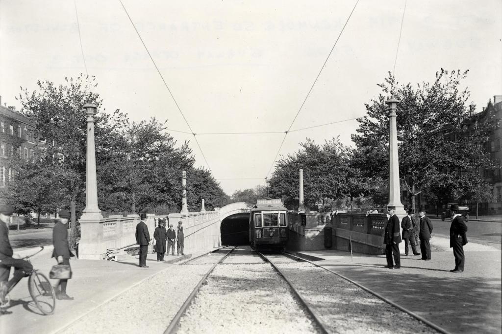
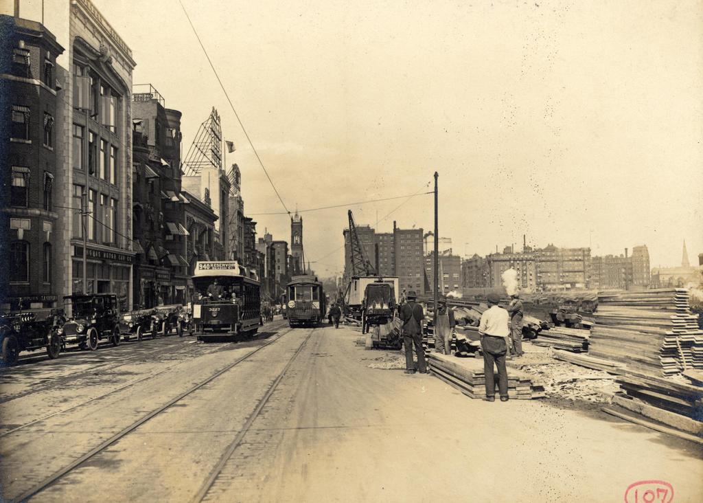
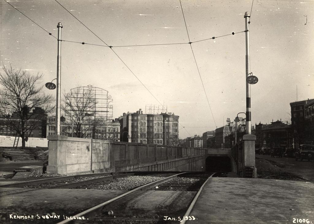
Facing east on Commonwealth Avenue toward Kenmore Square, with the Blandford Street Incline in the foreground, on January 3, 1933. Image courtesy of the City of Boston Archives.

710_1933-01-05 coba

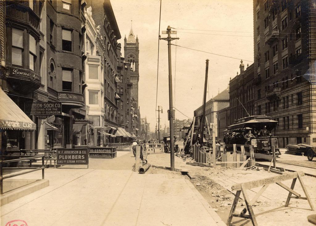
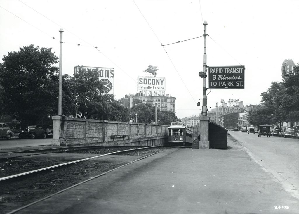
The same location in 1943. Image courtesy of the City of Boston Archives.
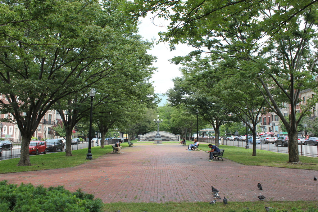
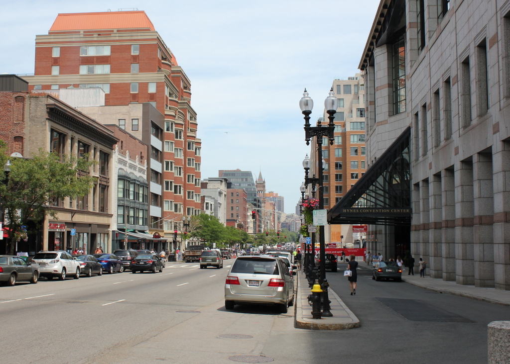
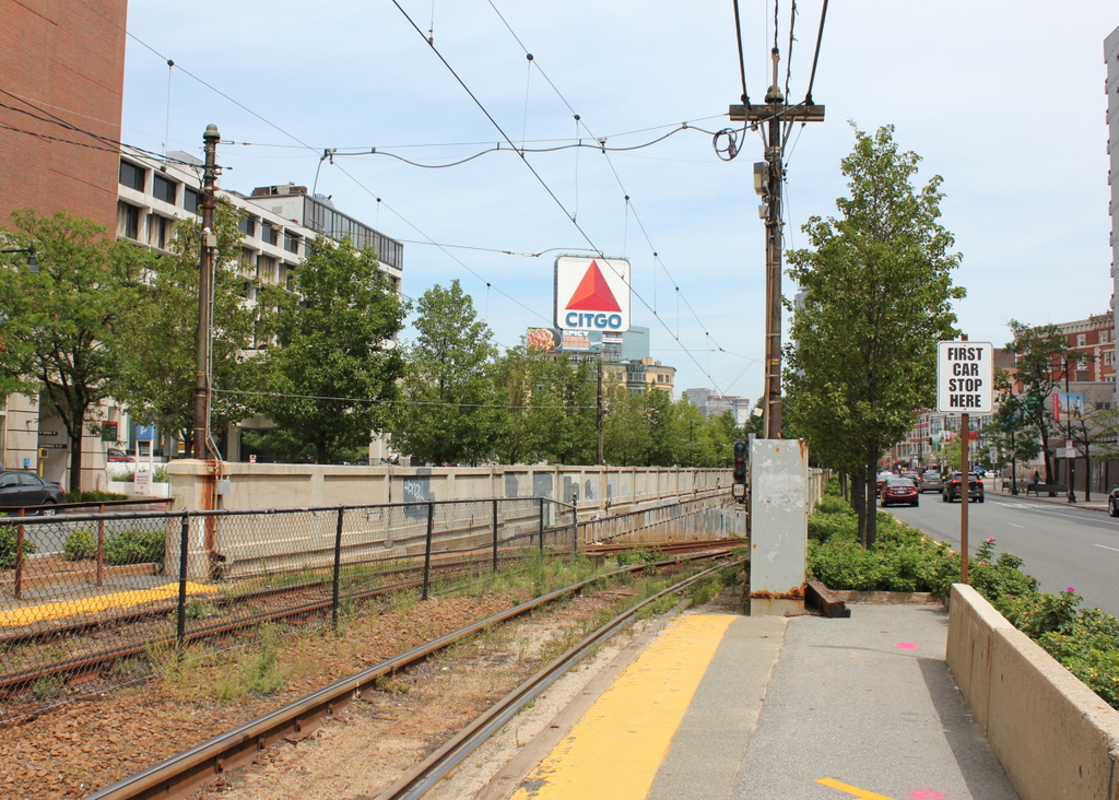
710_1943 coba

The view in 2015:

710_2015
As mentioned in this post, trolley cars once entered and exited the subway from an incline in the median of Commonwealth Avenue just east of Kenmore Square.  However, in 1932 the tunnel was extended a little to the west, with one branch emerging here, at the present-day Boston University campus.  The first photo shows the incline shortly after it opened, and not much had changed ten years later when the second one was taken.

The most obvious change in the first two photos is the signs – by 1943 Kenmore Square had become home to many large advertisements, including ones for Dawson’s Pale Ale and Lager, Socony, the Hotel Kenmore, and Gulf.  Several of these signs were easily visible from Fenway Park, with the Gulf sign in particular being prominent in photographs of the park from that era.  Another sign in the foreground indicates that Park Street is a mere nine minutes away, which either suggests that the trolleys ran much faster than they do now, or that the Boston Elevated Railway was being a little generous in their estimates.

The second photo also reveals a largely forgotten piece of Boston history; the trolley coming up from the tunnel has “National League Park” as its destination.  Long before the Red Sox, the Boston Braves were the city’s original Major League Baseball team, and from 1915 to 1952, they played about a mile up Commonwealth Avenue from here.  After the team moved to Milwaukee for the 1953 season, the old stadium was purchased by Boston University and converted into Nickerson Field, with some of the original structure still standing today.

In the 2015 scene, the subway incline hasn’t changed much; even the poles supporting the overhead wires appear to be the same ones from the first two photos.  To the left, the Boston University campus has continued to expand, and today several of BU’s buildings are visible here.  In the distance, many of the buildings in Kenmore Square are still standing, and although none of the 1940s signs still exist, Kenmore Square is now home to arguably the city’s most famous sign, which appears to be located at the same spot as the old Socony sign.  This Citgo sign is visible over the Green Monster at Fenway Park, and has been identified with the Boston Red Sox ever since it was first constructed in 1965.

Kenmore Subway Incline, Boston

The subway incline at Kenmore Square on October 2, 1914. Image courtesy of the City of Boston Archives.

708_1914-10-02 coba

The scene in 2015:

708_2015
When Boston’s first subway tunnel opened in 1897, it extended as far west as the Boston Public Garden, where trolleys came to the surface and traveled west along Boylston Street.  However, because of the traffic congestion, the tunnel was extended a little over a mile to Kenmore Square, with cars surfacing just east of the square in the median of Commonwealth Avenue.  From here, the trolley lines split and either continued on Commonwealth Avenue (today’s B branch), or turned onto Beacon Street (today’s C branch).  The first photo was taken a day before the line officially opened in 1914, and the trolley car has a “Special Car” sign on top of it.  Less visible on the side of the car is a poster that reads “The Boylston Street Subway will open Saturday,” which was October 3.  The first photo was taken just to the left of the one in the previous post, probably only a few years later.

This subway incline ended up being used for just 18 years.  In 1932, the tunnel was extended under Kenmore Square, where it split into today’s B and C branches of the Green Line before surfacing just west of the square.  The original incline was closed off, and the Commonwealth Avenue Mall reverted back to its pre-1914 appearance.  Today, the only remaining trace of it is the arch in the distance, which once formed the top of the tunnel.

Boston & Albany Rail Yard, Boston

The Boston & Albany yard along Boylston Street in Boston’s Back Bay, on October 4, 1912. Image courtesy of the City of Boston Archives.

702_1912-10-04

The view in 2015:

702_2015
The Boston & Albany Railroad maintained a rail yard on this site in the Back Bay for many years, but as the city continued to grow around it in the 20th century, it began to be eyed for potential redevelopment.  The yard took up most of the triangular-shaped area between Boylston Street, Huntington Avenue, and Dalton Street, which included the entire south side of Boylston Street west of Exeter Street, as seen in the 1912 photo.  The first photo shows some familiar landmarks on the left, including the firehouse on the far left, the Tennis and Racquet Club, and in the distance the tower of the New Old South Church.  All three are still standing today, but the view to the right has changed significantly.

By the early 1960s, there were several different options for redeveloping the rail yard.  In 1957, the Massachusetts Turnpike had been completed from the New York border to Route 128 in Weston, just outside Boston.  From there, however, it was uncertain which route the highway would take into the city. One option was to build it parallel to the right-of-way of the Boston & Albany Railroad, which would have included passing through this yard.

One of the problems with running the highway through here, though, came when the Prudential Life Insurance Company purchased the yard, with the intent of building a large complex that would include the tallest skyscraper in the city.  Such a plan would be a great economic benefit to the city, but it threatened the highway that would also serve the economic interests of the city.

In the end, both proposals went through, and the Massachusetts Turnpike was completed through here in 1965, a year after the Prudential Tower was completed directly above it.  Today, as seen in the 2015 photo, the highway runs parallel to the railroad, and they both pass under the Prudential complex and the Hynes Convention Center, which can be seen in the foreground. In the distance to the right is the lower part of the Prudential Tower, which 51 years after its construction is still the second-tallest building in the city.

Boylston Street, Boston (2)

Looking east on Boylston Street from near Hereford Street, on June 7, 1912. Image courtesy of the City of Boston Archives.

699_1912-06-07 coba

Boylston Street in 2015:

699_2015
These two photos don’t line up perfectly, but they are close.  The building just beyond the trolley on the left is the same one on the far left of the 2015 photo, so the 1912 photo just shows the view from a little further back.  Both illustrate some of the dramatic changes to Boylston Street, especially on the right side.  This section of the Back Bay south of Boylston Street was once a rail yard for the Boston & Albany Railroad, and there were no buildings on this side of the street west of the Hotel Lenox at Exeter Street.

Today, many of the early 20th century buildings on the left side of the street are still standing, but the right side has been completely redeveloped.  This section between Boylston Street an Huntington Avenue now includes the Prudential Tower, the rest of the Prudential Center complex, as well Hynes Convention Center, which is in the foreground of the 2015 photo.  The rail yard is gone, but the main tracks are still there, parallel to the Massachusetts Turnpike.  Both the tracks and the Pike run underneath the Hynes Convention Center, just to the right of where the photo was taken.

Boylston Street, Boston

The view looking east on Boylston Street from just west of Exeter Street, on July 19, 1912. Image courtesy of the City of Boston Archives.

696_1912-07-19 coba

Boylston Street in 2015:

696_2015
These photos were taken a little over a block away from where the the photos in the previous post were taken, and they show Boylston Street in the area just west of Copley Square.  The first photo was taken during construction of the Boylston Street Subway, which was completed in 1914 and allowed trolleys, such as the one seen in the photo, to travel under Boylston Street along the present-day Green Line.

Most of the older brownstone buildings seen on Boylston Street in the first photo have since been demolished, but many of the newer commercial buildings are still standing today.  These include, on the left side of the street, the small white building, which was built around 1908, and the larger red brick building beyond it.  In the distance is the tower of the New Old South Church, which was rebuilt in 1940 and today is partially hidden in this view.

On the right-hand side of the street, the McKim Building of the Boston Public Library can be seen in the distance; it was completed in 1895, and is still the main branch of the Boston Public Library today.  However, the library has long since outgrown the original building, so today the circulating collections are housed in the much more modern-looking Johnson Building, which was completed in 1972 and can be seen in the right center of the photo.  On the far right of both photos is the Hotel Lenox, which was built around 1901 and is still a hotel today, with few changes to the building’s exterior appearance.

One item of interest from the first photo is the trolley to the right.  It is overflowing with passengers, some of whom appear to be hanging on to the outside of the car.  There is a poster on the front of the car that reads “Baseball To-day, American League,” so these passengers were probably heading to Fenway Park, which had opened just a few months earlier.  On this particular day, the Red Sox were playing a doubleheader against the White Sox; Boston would end up winning both games, and later in the season they defeated the New York Giants in the World Series to win the team’s second championship title.  Over a century later, many Red Sox fans still take this route to Fenway Park, although today the trolleys run under the street in the tunnel that was being built in the first photo.

Park Street Subway Station, Boston (4)

Another view of the Park Street station on the Tremont Street Subway, taken on July 31, 1897. Image courtesy of the City of Boston Archives.

694_1897-07-31 coba

The station in 2015:

694_2015
The first photo shows the interior of Park Street station as it appeared about a month before it opened as one of the first two subway stations in the United States.  It was taken from around the same location as the one in the previous post, just facing the opposite direction.  These two photos, taken nearly 120 years apart, show some of the changes that have taken place over the years inside this historic station.  The original 1897 trolley platforms soon became inadequate for the number of passengers that used the station, so from 1914 to 1915 they were extended to the south, which is why the station appears much larger in the 2015 photo.  Other changes have included removing the two stairwells that can be seen at the southern end of the platforms in the first photo; today, the station can only be accessed through the entrances closest to Park Street.

Not everything has changed, though.  One of the defining features of the Green Line is that it still runs trolleys rather than conventional rapid transit subway cars like those on the other three subway lines.  As a result, the station platforms are level with the tracks, and there is no third rail, with power instead being supplied by overhead wires.  Many of the destinations haven’t changed either.  Although Boston’s trolley network is significantly smaller than it was in 1897, many of the places on the sign in the first photo can still be accessed from here, including the Back Bay, Copley Square, Brookline, Allston, Brighton, and Newton.