North Pearl Street from State Street, Albany, New York

Looking north on North Pearl Street from the corner of State Street in Albany, around 1904. Image courtesy of the Library of Congress, Detroit Publishing Company Collection.

The scene in 2019:

Pearl Street is one of the main north-south streets through downtown Albany, and these photos show the view looking north from the corner of State Street. When the first photo was taken, much of the streetscape consisted of four-story brick Italianate-style commercial buildings from the second half of the 19th century. However, the one major exception was the Albany Savings Bank, which stands on the left side of the scene. The building, with its Corinthian columns and large dome, was designed by noted architect Henry Ives Cobb, and it was constructed in 1898.

Just to the left of the bank was another notable downtown building, the Tweddle Building. It stood at the corner of State and North Pearl Streets, and it is more visible in a photo from an earlier post, which shows it from State Street. Here on the North Pearl Street side of the building, it had several different retail tenants on the ground floor. Starting on the far left side of the first photo, it housed “Cut Price Druggists,” which had a window advertisement for “Lime-Ade,” declaring it to be “First Aid to the thirsty.” Just to the right of the drugstore is the Whittle Brothers florist shop, and further to the right is the umbrella shop of J. McElwee, which had an outdoor display advertising for “Covering and Repairing” of umbrellas.

Elsewhere in the first photo, a number of signs adorn the sides of the buildings and extend outward across the sidewalk, hoping to catch the attention of the pedestrians. On the far right side near the foreground, these included the Albany & Troy Candy Kitchen, the Hallwood Cash Register Company, Harry Ellis’s men’s furnishings shop, the W. F. Antemann & Son jewelry shop, and the Joseph Feary & Son boot and shoe store. Antemann’s shop was marked by a large pocket watch sign, but many of his competitors apparently had the same idea, since there are at least three similar pocket watch signs visible across the street on the left side. Also on the left side, just beyond the bank, is Failing’s Apothecary, with a name that inspires even less confidence than the competing “Cut Price Druggists” a block away.

On the street, the traffic in the photo consists primarily of horse-drawn wagons. The most visible of these is the well-decorated wagon of the Grand Union Tea Company, on the far left side of the photo. The driver is perhaps delivering tea to the Cut Price drugstore, and the horse is staring directly at the camera. There are no automobiles visible in the photo, although by this point there were already thousands registered in the state of New York, and within just a few years they would largely displace the horse-drawn vehicles. In the meantime, though, the only sign of new transportation methods in the first photo is the electric trolley in the distance.

Today, around 115 years after the first photo was taken, very little remains of the early 20th century scene, especially here in the foreground. Cars now dominate the street, with not a draft animal in sight, and even the trolleys are long gone, having been replaced by buses, such as the one in the lower center of the 2019 photo. Most of the buildings here are also gone. Among the first to be demolished was the Tweddle Building on the far left, which was replaced by the 17-story Ten Eyck Hotel in the mid-1910s. This hotel was then demolished in the early 1970s, around the same time as the Albany Savings Bank building. The spot where the hotel once stood is now a modern office building, and the site of the bank is the Ten Eyck Plaza.

Despite all of the changes, though, there are a few surviving buildings near the foreground on the right side of the scene. Closest to the camera is the four-story building at 23-25 North Pearl Street, which was occupied by Feary’s boot and shoe store in the first photo. It was built in 1854, and it is still standing today, with few significant exterior changes aside from the storefronts. A little further north, just beyond Maiden Lane, are two other historic buildings, at 29-31 North Pearl Street. These were built in 1869 and feature distinctive cast iron lintels over the windows. The main facade of 29 North Pearl was altered at some point in the 20th century with a Tudor-style appearance, but otherwise the buildings are still recognizable from the first photo.

Overall, the best-preserved section of this scene is far in the distance. The two blocks between Pine and Columbia Streets are still lined on both sides with predominantly 19th and early 20th century buildings. These include the former YMCA building, site of the first basketball game played away from the sport’s Springfield birthplace, and the Kenmore Hotel, an ornate High Victorian Gothic building that opened in 1878. These buildings, along with the other historic buildings in this scene, are now part of the Downtown Albany Historic District, which was added to the National Register of Historic Places in 1980.

State Street from South Pearl Street, Albany, New York

Looking west on State Street from near the corner of State and South Pearl Streets in Albany, around 1904. Image courtesy of the Library of Congress, Detroit Publishing Company Collection.

The scene in 2019:

State Street is the main east-west route through downtown Albany, originally starting at the Hudson River wharves and extending westward up the hill in a straight line toward the state capitol. It provided a direct link between the city’s water and rail transportation and its government institutions, and in the process it passed through the heart of Albany’s central business district, which is shown here in these two photos.

The first photo was taken around 1904, and it shows a busy street scene. Dozens of pedestrians are visible walking on the sidewalks and crossing the street, and there is also a mix of horse-drawn wagons, along with at least three trolleys traveling up and down the hill. Automobiles are conspicuously missing from the scene, but this would not last long. The New York state legislature, meeting in the state capitol at the top of the hill here, had passed the first motor vehicle registration laws in the country in 1901, and by 1904 the state had some 15,550 registered cars on its roads.

The buildings on either side of State Street in the first photo reflect the changes in architectural styles during the late 19th century, along with the city’s growth during this same time. Starting on the far left is the Globe Hotel, which is perhaps the oldest building in the photo. It appears to have been built around the mid-19th century, and by the time the first photo was taken it housed the hotel, along with a number of retail tenants. These included a fruit market at the corner of South Pearl Street, and the photographic supply shop of Finch & Hahn on the State Street side of the building.

Further in the distance, towering above the Globe Hotel, is the Albany City Savings Institution building, which was probably the newest building in the first photo. This large Beaux-Arts building was designed by noted local architect Marcus T. Reynolds, and it opened in 1902 as the city’s first skyscraper. Just beyond the bank is another new building, the Empire Theatre, a burlesque theater that opened here in 1898.

On the other side of State Street, starting in the foreground, is the Tweddle Building. It was built at the corner of North Pearl Street in the mid-1880s, replacing the earlier Tweddle Hall, which had been destroyed in a fire in 1883. Beyond it is the Ten Eyck Hotel, with a painted sign on the side of the building proclaiming it to be “positively fire proof.” The nine-story hotel opened in 1899, filling a void in Albany’s hotel business after the Delavan House burned in 1894. This disaster, which claimed the lives of 16 people, would have still been fresh in people’s minds when the Ten Eyck opened, and likely explains why the owners went to such lengths to advertise its fireproof construction.

Beyond the Ten Eyck, on the other side of Chapel Street, is the Albany Savings Bank. This ornate building was completed in 1875, and it was occupied by the bank until the late 1890s, when the bank moved to a new building on North Pearl Street. The county then purchased the building, and it was in use as county offices when the first photo was taken.

Further up the hill from the bank building are two other commercial blocks, followed by St. Peter’s Episcopal Church on the other side of Lodge Street. The main portion of the church was designed by architect Richard Upjohn, who was particularly well-known for his Gothic-style churches. It was consecrated in 1860, but in 1876 the parish added the 180-foot tower, which was designed by Upjohn’s son, Richard M. Upjohn.

At the top of the hill, in the distant center of the first photo, is the New York State Capitol. Construction on the capital had begun in 1867, but it was not completed until 1899, when Theodore Roosevelt was governor. By the time the first photo was taken, Roosevelt had become president, but less than a decade later another politician with the same last name would arrive at the capitol. Franklin Roosevelt served here as a senator from 1911 to 1913, and he later returned as governor, serving from 1929 until he was elected president in 1932.

Today, nearly 120 years after the first photo was taken, the capitol still dominates the background of this scene. It remains in use as the seat of the state government, although it has since been joined by a number of other government buildings, including the 34-story Alfred E. Smith State Office Building, which rises above the roof of the capitol in the present-day photo.

However, most of the other buildings in this scene at the turn of the century are gone now, including everything in the foreground. The Globe Hotel was altered beyond recognition in the early 20th century, and was known as the Arkay Building until the late 1920s, when it was demolished to build the National Savings Bank, which stands on the site today. Across the street, the Tweddle Building was demolished in the mid-1910s, and in its place the Ten Eyck Hotel built a new 17-story skyscraper. The hotel also continued to operate the older Ten Eyck, which became known as the Annex, and both buildings stood here until they were demolished in the early 1970s.

Further in the distance, only a few recognizable buildings from the first photo are still standing, aside from the capitol. On the left, the Albany City Savings Institution is still here, although it was altered in the 1920s with the addition of a large clock tower, and it is now mostly hidden from this angle by the National Savings Bank. Across the street, St. Peter’s Church is also still standing. Unlike the Savings Institution building, it has not been overshadowed by taller neighbors, and it continues to be a very prominent feature here on State Street. It remains an active Episcopalian parish, and in 1980 it was named a National Historic Landmark, becoming one of four Albany buildings, including the capitol, to receive this designation.

Union Station, Albany, New York

The platforms on the east side of Union Station in Albany, around 1904. Image courtesy of the Library of Congress, Detroit Publishing Company Collection.

The scene in 2019:

Taken nearly 120 years apart, these two photos capture one of the ways in which transportation changed in the United States over the course of the 20th century. The first photo shows a large, recently-completed downtown railroad station, with several trains waiting on the tracks and a group of people on one of the platforms. However, in the present-day scene the railroad station has been converted into offices, while the tracks and platforms are completely gone, replaced with a parking garage. Another even larger parking garage stands in the distance on the right side, and further to the right, just out of view, is an interstate highway.

Albany’s Union Station was completed in 1900, and it was primarily used by the New York Central and Hudson River Railroad. However, it was also used by the Delaware and Hudson Railway and the New York Central-controlled West Shore Railroad, and it was the western terminus of the Boston and Albany Railroad, which the New York Central had begin leasing earlier in 1900. The station building featured a granite, Beaux-Arts exterior, and it was designed by the prominent Boston architectural firm of Shepley, Rutan and Coolidge. This firm was particularly well-known for their railroad stations, and they designed a number of them for the Boston and Albany, including Union Station in Springfield and South Station in Boston.

The station was built at the corner of Columbia Street and Broadway, with the main entrance on the western side, facing Broadway. However, this view shows the other side of the station, looking north from the southern end of the platforms. Here, three large island platforms were situated between the tracks, and passengers could access them via two underground tunnels. The train on the left side of the first photo is a New York Central passenger train, with 4-4-0 locomotive number 1135 in the lead. Another unidentified locomotive stands on the far right side of the photo, and further in the distance just to the left of that train is a group of men—possibly railroad employees—leaning against and sitting on a row of baggage carts. These trains were just two of the 96 daily trains that served Union Station when it first opened at the turn of the 20th century. Of these, there were 42 New York Central trains, 31 Delaware and Hudson, 13 West Shore, and 10 Boston and Albany.

Passenger rail travel continued to increase nationwide throughout the first half of the 20th century, eventually peaking during World War II. This was also the busiest time for passenger trains in Albany, with 121 daily trains here at Union Station. However, the postwar period saw a sharp decline in ridership, a problem exacerbated by the development of the Interstate Highway System starting in the 1950s. By the 1960s, many of the railroad companies that had dominated the nation’s economy a half century earlier were now teetering on the brink of bankruptcy. As a result, the New York Central merged with its longtime rival, the Pennsylvania Railroad, in 1968, forming the Penn Central Railroad.

For nearly a decade prior to the merger, the New York Central had been looking to rid itself of Albany’s Union Station, which was under-utilized and expensive to maintain. The station was also near the path of the planned Interstate 787, which would cut through part of the station’s passenger yard. Soon after the formation of Penn Central, the newly-formed railroad opened a new, much smaller passenger station directly across the river from here in Rensselaer, and the old Albany station was unceremoniously closed on December 29, 1968.

A few months later, the New York Times published an “obituary” of the station, titled “In Melancholy Memory of Albany’s Union Depot.” The article lamented the closure of the grand station, recalling its long history during the heyday of passenger trains and contrasting its architecture with that of the new station, which was described as a “one-story crackerbox of concrete blocks.” At the time, the fate of the old station was still undetermined, but the article mentioned several different proposals, which ranged from converting it into a museum to demolishing it and building a high-rise luxury apartment building and marina on the site.

Ultimately, neither of these proposals materialized, and the building was instead converted into offices in the 1980s. It was originally the home of Norstar Bancorp, and it was initially named Norstar Plaza, although it was subsequently renamed Peter D. Kiernan Plaza after the death of the bank’s president. The bank then went through a series of mergers, and over the next two decades the building was home to Fleet Financial Group, FleetBoston Financial, and then Bank of America. The building was used by Bank of America until 2009, and it now serves as offices for several other companies.

Overall, the present-day scene is drastically different from the view in the early 20th century. The most dramatic change is the parking garage in place of the station tracks and platforms, but other changes have included the tall building just beyond the station on the other side of Columbia Street. However, the station itself has not seen many exterior changes since the first photo was taken, even though much of it is hidden by trees from this angle. Today it stands as an excellent work of Beaux-Arts architecture, and it also serves to highlight the benefits of historic preservation and adaptive reuse.

Pennsylvania Station, New York City

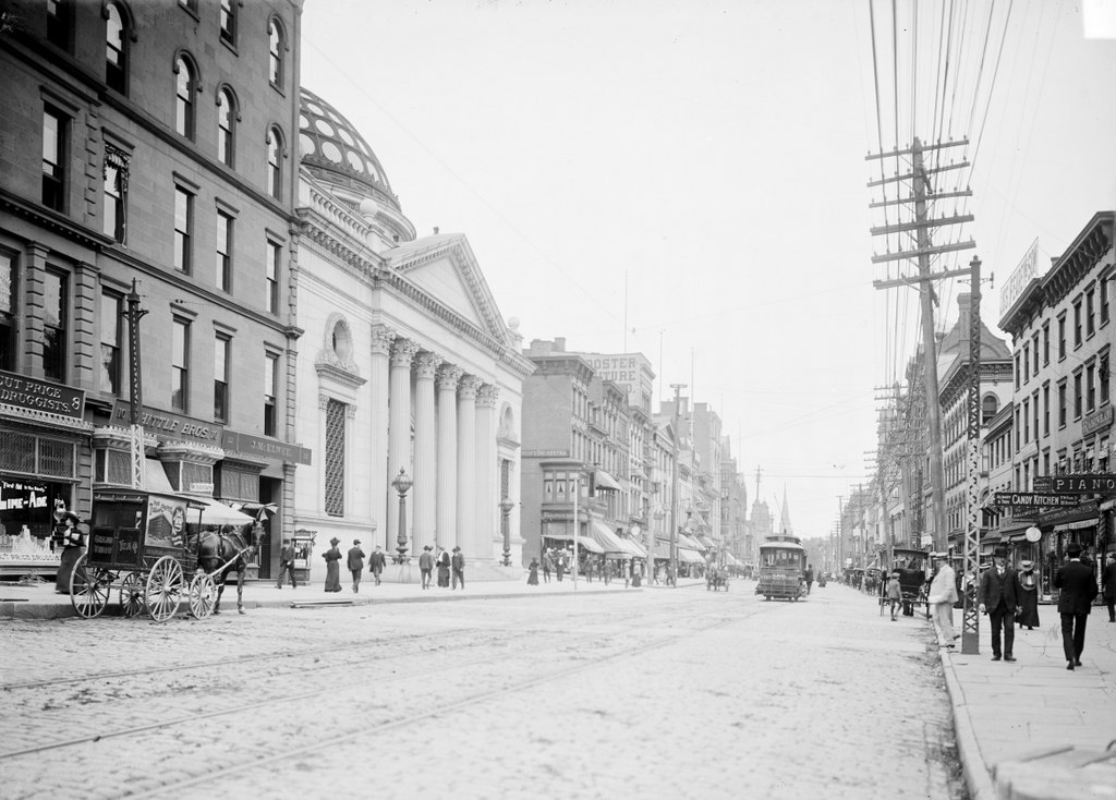
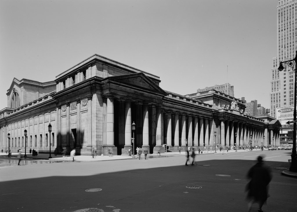
Pennsylvania Station, seen from the corner of 7th Avenue and 31st Street in New York City, probably in 1912. Image courtesy of the Library of Congress, Detroit Publishing Company Collection.

Pennsylvania Station on May 5, 1962. Image courtesy of the Library of Congress, Historic American Buildings Survey Collection.
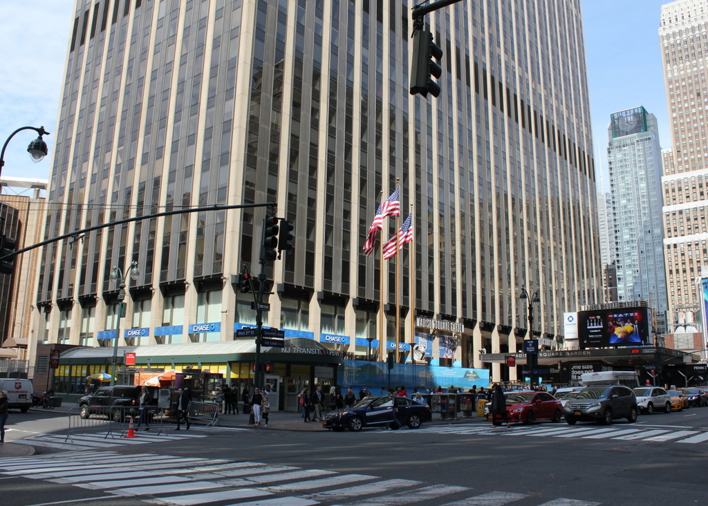
The scene in 2019:

During the heyday of rail travel in the late 19th and early 20th century, passenger stations in major cities were typically large, ornate buildings. As the first place that most travelers would see upon arriving in a new city, these stations sought to convey a strong first impression by demonstrating the importance and grandeur of both the city and the railroad company. Consequently, when the Pennsylvania Railroad—one of the largest corporations in the world at the time—constructed a rail line into the largest city in the country, it built what was arguably the grandest railroad station in American history.

Throughout the 19th century, the Hudson River was a major obstacle for railroad traffic heading to and from New York City. At the time, Manhattan’s only direct rail link was to the north, across the narrow Harlem River. This connected the city to upstate New York, New England, and other points north and east, but travel was much more difficult when heading south or west. In the absence of bridges or tunnels, the only way for these railroads to reach Manhattan was by ferry from the New Jersey side of the river.

As early as the 1880s there were proposals to bridge the Hudson, but these would have been prohibitively expensive, given the necessary height of the bridge and the amount of valuable Manhattan real estate that would have been required for the approaches. The only other option was to tunnel under the river, but this did not become a viable alternative until the development of electric locomotives, as there would have been no way to provide ventilation for steam locomotives in the tunnel. Even then, it would entail significant expense and engineering challenges along the way, not least of which was the difficulty of tunneling through the viscous mud on the riverbed.

The final plans consisted of two parallel tunnels under the Hudson River, which would bring Pennsylvania Railroad trains into the heart of Manhattan at a new station in midtown. This would be done in conjunction with the Long Island Rail Road, which was building similar tunnels under the East River. These tunnels would meet the Pennsylvania Railroad here at the new station, providing direct rail access to Manhattan for Long Island commuters.

Work on both the Hudson River and East River tunnels began in 1904, as did the excavation work for the new Pennsylvania Station. The station site occupied two full city blocks, and it was bounded by West 31st Street, West 33rd Street, 7th Avenue, and 8th Avenue, in the middle of the city’s Tenderloin neighborhood. This spot was four blocks west and nine blocks south of the city’s other major rail hub, Grand Central Terminal, which was operated by the Pennsylvania Railroad’s rival, the New York Central.

Pennsylvania Station included 11 tracks and 21 platforms, but its most notable feature was its above-ground portion, shown here in this view along 7th Avenue. The massive building was designed by the prominent architectural firm of McKim, Mead & White, and it is often regarded as their magnum opus. It featured ornate Beaux-Arts architecture, with an exterior of pink granite that was lined with columns and other classically-inspired elements. Here on the east side of the building, the main entrance was topped by a large clock, with allegorical representations of Day and Night on either side. The clock was also flanked by six eagles, with three on each side. All of these statues, along with the matching figures above the other three entrances to the station, were the work of noted sculptor Adolph Weinman, who is perhaps best known for designing the Mercury dime and the Walking Liberty half dollar.

On the interior, the main entrance opened to a 225-foot long, 45-foot wide arcade that was lined with shops. This led to the main waiting area in the center of the building, which spanned the width of the station from West 31st Street to West 33rd Street and featured a ceiling that rose 150 feet above the floor. It was said to have been the largest such waiting room in the world at the time, and it included ticket offices, baggage check windows, and telephone and telegraph offices, in addition to two smaller adjoining waiting rooms, with one for men and one for women. Beyond the waiting room, on the west side of the building, was the main concourse, with its distinctive iron and glass arched ceiling. The station also included two covered carriage drives, which led down to the lower level. These were located on the north and south sides of the station, and they were accessed here on the 7th Avenue side, beneath the pediments on the left and right side of this scene.

Pennsylvania Station was completed in the late summer of 1910, and part of it opened on September 8. The rest of the station opened on November 27, drawing an estimated 100,000 visitors throughout the day, in addition to the 25,000 passengers on the more than 80 trains that arrived and departed from here. Aside from a few short early morning delays the opening went smoothly, and the station was easily able to accommodate the large crowds. Reporting on the opening day, the New-York Daily Tribune described the station as a “fresh mechanical miracle,” and further noted:

And in thousands they flooded the acres of its floor space, gazed saucer eyed like awestruck pigmies at the vaulted ceilings far above them, inspected curiously the tiny details of the place, so beautifully finished, on their own level and pressed like caged creatures against the grill which looked down upon subterranean tracks, trains and platforms. W. W. Egan, the station master, was of the opinion that some of them had been there all night. There was no let up all day, at all events, and late last night the steel and stone palace still entertained its thousands of liliputian admirers swarming in and out and round about.

Aside from its colossal dimensions and great distances, the most noteworthy feature of this human achievement is its silence. It’s too big to be noisy, too dignified in its spaciousness for staccato sounds. The steady hum of its tense life spells only peace, like the drone of bees in a summer garden. The stealthy trains circulate in its underworld unnoticed. Even the announcers’ calls fade into faraway song, echoing in a canyon.

The hordes of sightseers caused no indigestion in the huge maw of this monster. Passengers came and went or waited without inconvenience or crowding, though they were outnumbered fifty to one. A delay here and there in providing car equipment, due to untried complications at the Harrison transfer station, only accentuated the general smoothness with which the eighty-four trains to and from the West were operated.

The first photo was taken within a year or two after the station opened, probably sometime in 1912. The presence of many horse-drawn vehicles suggests an early 1910s date, but the most helpful clues in dating the photo are the advertisements for Broadway shows, which are visible on the extreme right side of the photo. These productions, which include The Master of the House, The Little Millionaire, Hanky Panky, and Little Women, all premiered in either 1911 or 1912.

Penn Station, as it was commonly known, remained in use throughout the first half of the 20th century, with ridership here peaking during World War II. However, this quickly began to change after the end of the war, as commercial airlines and private automobiles began to eclipse railroads for long-distance travel. Railroads across the country began to struggle financially, including the once-mighty Pennsylvania Railroad, which had difficulty maintaining its iconic station here in New York.

This neighborhood, which had been a red light district prior to the construction of Penn Station, was valuable Midtown real estate by the mid-20th century. In addition, the cavernous station that had so impressed visitors in 1910 was both costly and underutilized, so in 1954 the railroad optioned the air rights to a developer. This agreement would allow for the demolition of the above-ground portion of the station, leaving only the tracks and platforms from the original structure.

Nothing came of this initial plan, but in 1962 the site became the subject of a new redevelopment proposal, which would involve demolishing the station, constructing a new, smaller station underground, and building a new Madison Square Garden and an office building atop it. The second photo was taken around this time, in May 1962, evidently as part of an effort to document the building’s architecture before its demolition. By this point, the interior had undergone some significant changes since the station opened, but the 7th Avenue facade was largely unchanged from this angle, aside from the accumulation of a half century of grime on the pink granite walls and columns.

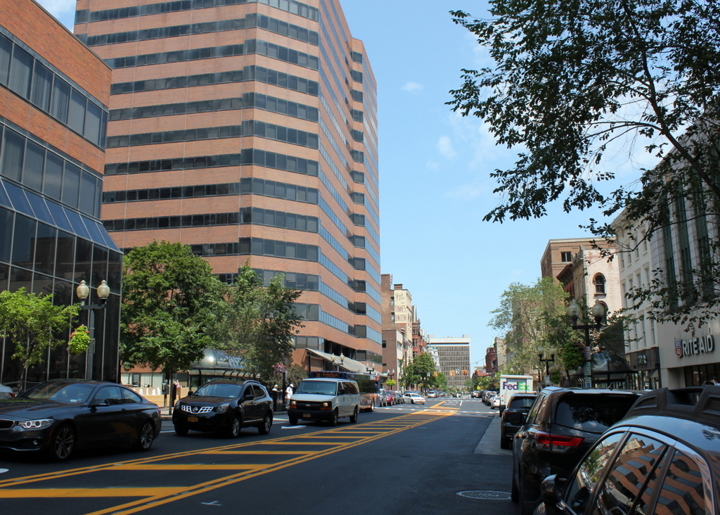
These redevelopment plans caused significant controversy, as Penn Station was still a major New York landmark, despite the reduced importance of rail travel. However, demolition began in October 1963, just over a year after the second photo was taken, and the building was mostly gone by 1966. Madison Square Garden opened in 1968, and occupied the western two-thirds of the site. In the present-day scene, it is barely visible on the far left side of the photo. To the east of it is an office building, which stands in the foreground of the photo along 7th Avenue.

The reconstructed Penn Station was also completed in 1968, although almost none of it can be seen above ground aside from the entrances, one of which is visible in the lower right side of the photo. It remains in use as New York’s primary intercity rail station, and it is the busiest station in North America, with an annual ridership of over 100 million. However, it lacks all of the grandeur and architectural distinction of its predecessor, and its design is particularly unimpressive compared to the historic Grand Central Terminal, which still stands as the city’s other major railroad station.

In hindsight, though, the loss of the original Penn Station may not have been entirely in vain. The demolition helped to draw attention to the need for historic preservation, at a time when many important buildings were being lost to urban renewal projects in cities across the country. Here in New York, it led to the creation of the New York City Landmarks Preservation Commission, in order to protect significant buildings in the city. These included Grand Central Terminal, which was threatened by a similar redevelopment proposal that would have put a skyscraper atop the station building. This was successfully blocked by the Commission, and their ruling was upheld in a 1978 Supreme Court decision, thus preserving Grand Central in its historic appearance.

Union Station, White River Junction, Vermont

The railroad station at White River Junction, around 1900. Image from The Gateway of Vermont: Hartford and its Villages (1903).

The scene in 2018:

As discussed in an earlier post, the village of White River Junction is situated at the confluence of the White River and Connecticut River, on the border of Vermont and New Hampshire. Once sparsely-settled farmland within the town of Hartford, this area became an important railroad crossroads in the late 1840s, as new rail lines began spreading across northern New England.

By 1850, there were four different railroads that met here in White River Junction: the Vermont Central Railway from the northwest, the Connecticut River Railroad from the south, the Connecticut and Passumpsic Rivers Railroad from the north, and the Northern New Hampshire Railroad from the east. A fifth line, the Woodstock Railroad, was built in 1875, connecting White River Junction to the town of Woodstock, located 14 miles west of here.

The arrival of the railroads led to a small but thriving village, which was centered around the depot here, where the rail lines met. The first passenger station opened here on this spot in 1849. It was a union station, meaning that it was used by all of the railroads. This original depot burned in 1861, in a large fire that began in a nearby factory. The flames quickly spread, destroying a number of industrial buildings and warehouses, along with both the passenger and freight depots. It was one of many fires that hit White River Junction during the late 19th and early 20th centuries, and it was the first of three stations here that would be destroyed by fires.

The replacement station was completed here in 1862, but it burned within a couple decades, and around 1880 it was replaced by a third station, which is shown here in the first photo. It was from this station that, in the early morning hours of February 5, 1887, a northbound Central Vermont passenger train departed, heading for Montreal. However, just ten minutes later, at a bridge less than five miles northwest of here, the last four cars of the train derailed and fell onto the frozen White River. The cars caught fire with many passengers and crew trapped inside, and an estimated 37 people were killed, making it the deadliest rail accident in Vermont history.

The first photo was taken around the turn of the 20th century, showing the view of the station from the northwest. By this point, the various rail lines here at White River Junction had been consolidated into the Boston & Maine Railroad and the Central Vermont Railway. The Boston & Maine owned two-thirds of the station, with the Central Vermont owning the remaining third. These two companies controlled a significant portion of the rail traffic in northern New England, and White River Junction remained an important hub within their networks. In addition, the station housed a restaurant and the local telegraph office, which served as a major relay point for communications between Boston and Montreal.

Like its two predecessors, this station was also destroyed by a fire, which started on the morning of November 28, 1911. It evidently began as a result of faulty wiring in the telegraph office, and it soon consumed the entire building. The station was a total loss, but valuables such as the mail, baggage, and the contents of the ticket office were safely removed, and firefighters prevented the flames from spreading to neighboring buildings.

A day after the fire, the Barre Daily Times expressed optimism that the fire would lead to a new, improved station here, noting:

Now is the time for the Central Vermont and Boston & Maine railroads to get together and build a union station at White River Junction that will be just right. With the old station in ruins, they will have to start over again, and the new project ought to be accomplished with the added features, such as subways to the business streets of the village.

Evidently not everyone shared this hope for the future, though, because a few days later the Times quoted the Springfield Republican of Massachusetts, which had written “Travelers will find waiting at White River Junction, Vt., drearier than ever now that the railroad station has been burned.” To this, the Times added “Nevertheless, they ought to be able to find amusement in delving in the mysteries of antiquity, meaning the ruins of the old station.”

As it turned out, the Republican‘s assessment of the situation proved particularly accurate. For more than 25 years after the fire, passengers had to use a converted freight house as a temporary station, as the two railroads squabbled over the construction of its replacement. The new station, shown here in the present-day photo, was finally completed in 1937. It featured a Colonial Revival exterior that was designed by Jens Fredrick Larson, a noted architect and World War I flying ace who designed much of the campus at nearby Dartmouth College.

Today, more than 80 years after the station opened, the two railroad companies that built it are now long gone, and White River Junction is no longer the major passenger rail hub that it once was. The station is still here, and it remains in active use, although its passenger service is limited to just two daily trains on Amtrak’s Vermonter route, a significant drop from a village that, at its peak, saw up to 50 passenger trains stop here every day.

However, there are remnants of the past here in the present-day scene, including Boston & Maine engine #494, which is visible under the pavilion in front of the station. It was built in 1892 by the Manchester Locomotive Works in New Hampshire, and it remained in use until 1938. A year later it was an exhibit the 1939 World’s Fair, and in 1957 it was donated to the town of Hartford, which eventually restored it and put it on display here. In the 2018 photo, it contrasts with the modern diesel locomotive on the far right, which is operated by the New England Central Railroad, the successor to the Central Vermont.

Old North Bridge, Concord, Mass (3)

Looking west across the Old North Bridge over the Concord River in Concord, around 1875-1885. Image courtesy of the New York Public Library.

The scene around 1900-1909. Image courtesy of the Library of Congress, Detroit Publishing Company Collection.

The scene in 2018:

As discussed in more detail in an earlier post, the Old North Bridge over the Concord River was the site of the Battle of Concord at the beginning of the American Revolution. It occurred on April 19, 1775, only a few hours after the opening shots of the war in nearby Lexington, and it was the first American victory of the war, resulting in the British abandoning their search for colonial munitions and returning to Boston.

Because of its historical significance, the battlefield is now marked with two monuments. On the east side of the river, directly behind the spot where this photo was taken, is a granite obelisk dedicated in 1837, and on the west side of the bridge is the statue The Minute Man, visible in the distance of all three photos. This statue was the work of prominent sculptor Daniel Chester French, and it was dedicated on the 100th anniversary of the battle on April 19, 1775, in a ceremony that included dignitaries such as President Ulysses S. Grant.

Aside from the monuments, the most significant landmark here on the battlefield is the bridge. The original one was removed in 1788, and from 1793 to 1875 there was no bridge on this site after the roads were rerouted. However, as part of the centennial celebrations of 1875, a new one was built around the same time that the statue was installed. This bridge, shown here in the first photo, bore no resemblance to the original one. It was designed by noted architect William R. Emerson, and it featured a rustic Victorian-style design, with cedar logs for railings and two half-arbors at the middle of the bridge.

The centennial bridge was ultimately destroyed in a storm in 1888, and it was replaced by a simpler yet sturdier wooden bridge, as shown in the second photo. It was similar to, although not identical to, the original bridge here at this spot, and it stood here until it too was destroyed in 1909. Its replacement, built later in 1909, lasted until 1955, when it sustained serious damage in a flood. The current bridge was completed the following year, and it was designed to be a replica of the original colonial-era bridge.

In 1975, this bridge became a focal point for the bicentennial celebrations here in Concord. As was the case a century earlier, the event included a visit from the president, with Gerald Ford speaking from a platform here at the eastern end of the bridge, which was located just out of view on the right side of the scene. Since then, very little has changed here. The battlefield has been well-maintained in its 1775 appearance, and today the site probably looks more like it did on the day of the battle than in either of the two earlier photos. Much of this is due to the efforts of the National Park Service, which has administered the battlefield since 1959, when the bridge and the surrounding area became a part of the Minute Man National Historical Park.