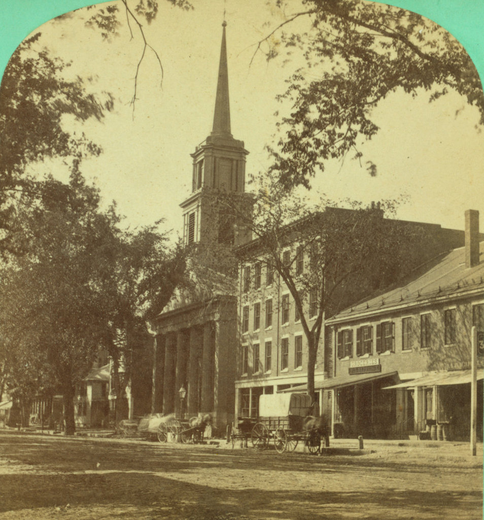
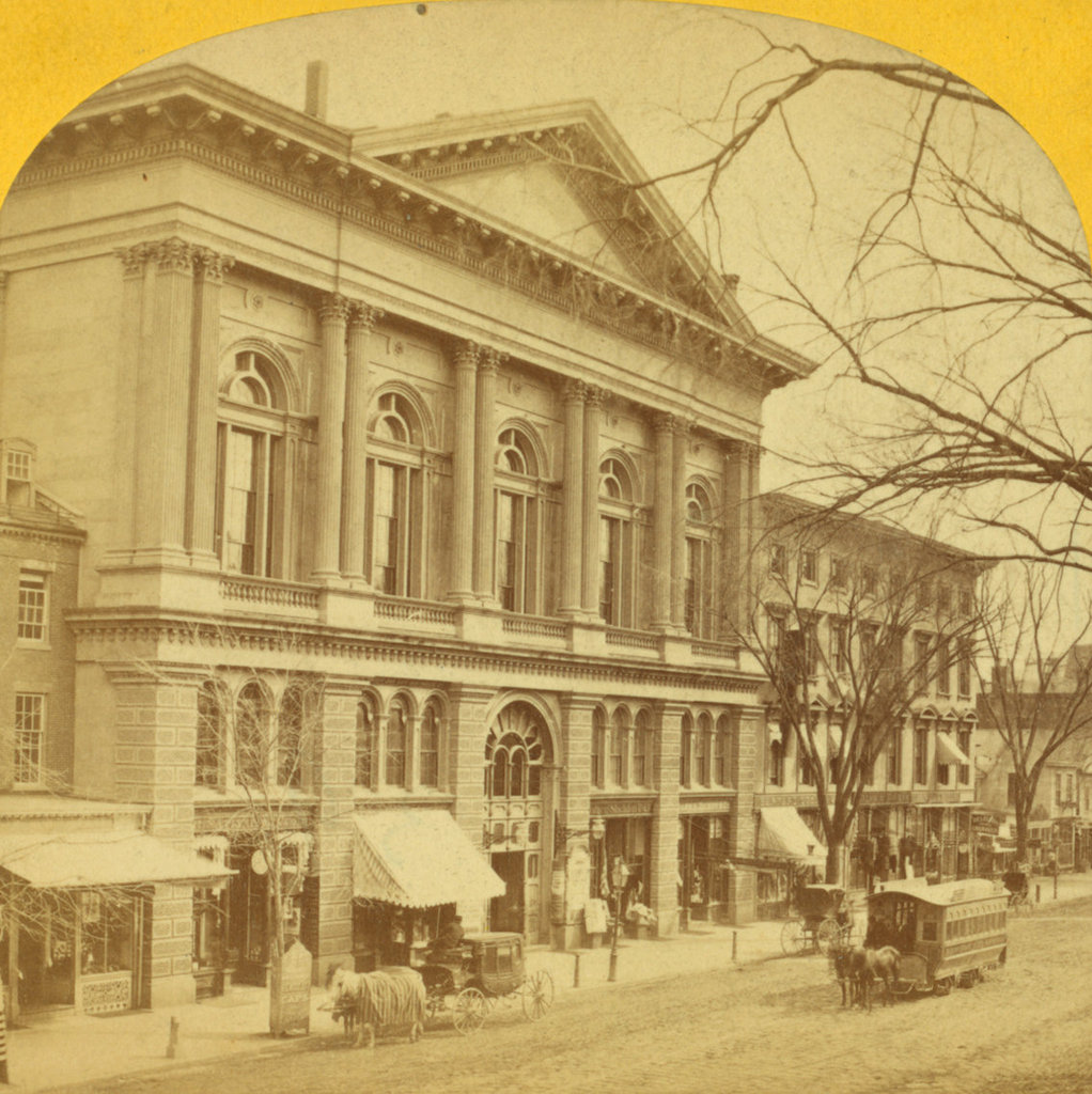
Calvinist Church, Worcester, Mass

Looking south along Main Street from near School Street in Worcester, with a view of the Calvinist Church building, sometime between 1865 and 1885. Image courtesy of the New York Public Library.

1015_1865-1885c-nypl

The scene in 2016:

1015_2016
Organized in 1820 after a split with the First Church, the members of the Calvinist Church met in different locations in Worcester until 1825, when this building was completed on Main Street, just North of George Street. It was built on the property of Daniel Waldo, a prominent local merchant who provided the land and paid the $14,000 construction costs. Architecturally, it fit in with the popular Greek Revival design of New England churches at the time, which most prominently included a portico with a triangular pediment, supported by large pillars.

Although located in the northern part of downtown Worcester, as the city grew this area became more commercially developed, as the first photo shows. Because of this, in 1885 the church moved into a new building a few blocks north of here, and the old 1825 building was subsequently demolished.

Today, the only building left from the first photo is the Elwood Adams Block, just to the right of the church. It was built in 1831 as a two and a half story commercial building, similar to the one next to it in the first photo, but in 1865 it was extensively renovated, adding two floors and an Italianate-style facade. At some point after the photo was taken, several other historic buildings were added to this scene. On the far right is the 1885 Armsby Block, and further down Main Street on the left side of the photo is the 1905 Thule Building. Along with the much older Elwood Adams Block, these buildings are all listed on the National Register of Historic Places.

Halfway House, Mt. Washington, NH

The Halfway House on the Mount Washington Carriage Road in New Hampshire, around the 1870s. Image courtesy of the Mount Washington Auto Road.

971_1870sc mwar

The scene in 2016:

971_2016
Mount Washington is the tallest peak in the northeastern United States, and it has been a popular tourist destination since the mid-19th century. By the end of the 1860s, the mountain had a hotel at the summit, along with both a cog railway and a carriage road to bring visitors to the top. The nearly eight-mile long carriage road opened in 1861, and this small building along the side of the road served an important purpose for early travelers. Known as the Halfway House, it was located about four miles up the road, hence the name, and it was used as a toll house. It was also a good resting place during the four-hour carriage ride up the mountain, and when necessary its location just below the treeline made it a refuge from the unpredictable and often dangerous weather in the alpine zone.

The building in the first photo was later replaced with a more substantial two-story structure. This one served the same purpose as the original, but over time it suffered from vandalism because of its isolated location, and it was finally destroyed by a fire in 1984. Today, the carriage road is now the Mount Washington Auto Road, and aside from cars replacing horses, not much has changed about the road, which still follows the same route that was laid out in the 1850s. The drive to the summit now takes about 30 minutes, and while the Halfway House no longer stands here, the site is still used as a stopping place. It is no longer necessary to rest horses here, but the climb is still taxing for cars, so the site here is used by drivers heading up the mountain to cool their radiators, and by those heading down to cool their brakes.

Matthews Hall, Cambridge, Mass

Matthews Hall at Harvard University, probably around 1872-1890. Image courtesy of the Boston Public Library.

959_1872-1890c bpl

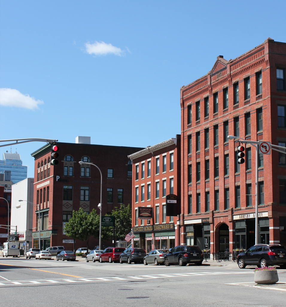
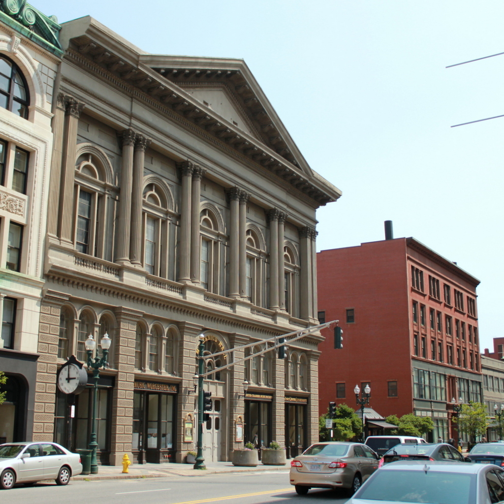
The building in 2016:

959_2016
The Gothic architecture of Matthews Hall is very different from the Georgian style of the neighboring Massachusetts Hall, which is some 150 years older. However, they both contribute to the appearance of the Old Yard at Harvard Yard, which includes a variety of historic 18th and 19th century buildings. Matthews Hall was one of the first buildings designed by Boston architectural firm Peabody & Stearns, and it was completed in 1872 as a dormitory, named for its benefactor, Nathan Matthews.

Today, Matthews Hall is still a dormitory, and like the others at Harvard Yard it is a freshman-only dorm. Over the years it has housed a wide range of notable students, including newspaper publisher William Randolph Hearst, Nobel laureate physicist Philip Warren Anderson, Senator Chuck Schumer, Secretary of the Treasury Robert Rubin, and actor Matt Damon.

Equitable Building, Boston

The Equitable Building at the corner of Milk and Devonshire Streets in Boston facing south on Devonshire Street, on June 17, 1875. Image courtesy of the Boston Public Library.

820_1875-06-17 bpl

The view down Devonshire Street in 2015:

820_2015
Like the photo in the previous post, taken just around the corner on Milk Street, this scene shows Boston during the 100th anniversary celebration of the Battle of Bunker Hill, when many of the city’s buildings were decorated with flags and patriotic bunting. The building in the foreground here was the home of the Equitable Life Assurance Society’s Boston branch, and it was also known as the Henry H. Hyde Building, after the company’s founder. This area was devastated by the Great Boston Fire of 1872, but within a few years the city had largely rebuilt, and in 1874 Equitable opened this elegant Second Empire style building as their Boston office, in a prominent location directly across from the Post Office, which can be seen to the left in the first photo.

Based on city maps, the Equitable Building was demolished sometime between 1912 and 1938, and was replaced with the old First National Bank Building. his was, in turn, demolished in the 1970s to build One Federal Street, a 38 story skyscraper that now fills the rectangular block between Milk, Devonshire, Arch, and Federal Streets. Since this is the heart of Boston’s Financial District and the home of many of its skyscrapers, there are no surviving buildings from the 1875 photo in the 2015 scene.


Milk Street, Boston (2)

Looking west up Milk Street from Devonshire Street in Boston, on June 17, 1875. Image courtesy of the Boston Public Library.

819_1875-06-17 bpl

Milk Street in 2015:

819_2015
When the first photo was taken, the city was celebrating the 100th anniversary of the Battle of Bunker Hill, and these buildings on Milk Street were covered in patriotic bunting. All three of the buildings in the center of the photo were new; just three years earlier the area had been destroyed in the Great Boston Fire of 1872, as seen in the view looking down Milk Street in this post. However, the city soon rebuilt, and this area quickly became a major commercial center again.

All three of these buildings survive today, although with some alterations. The one on the left, at the corner of Milk and Hawkey Streets, is the Goddard Building. It was completed in 1873, and over the years it has been expanded, with two additional stories on top. The building to the right of it has also grown over the years. It was built on the site of Benjamin Franklin’s birthplace, and the decorative facade includes a bust of Franklin above the second story windows. The third building in the photo, on the right, was also built in 1873, at the corner of Milk and Washington Streets. It was originally the home of the Boston Transcript newspaper, which at the time was the largest circulating daily newspaper in New England. The newspaper has been defunct since 1941, but the historic building is still standing today.

Boylston Market, Boston

Boylston Market, at the corner of Boylston and Washington Streets in Boston, around 1870. Image courtesy of the Boston Public Library.

816_1870c bpl

The scene in 2015:

816_2015
Boylston Market was built here in 1810, and it was designed by noted architect Charles Bulfinch. It functioned as a market on the first floor, and a meeting space and performance hall on the third floor, known as Boylston Hall. Both the building and the street were named for Ward Nicholas Boylston, a Boston philanthropist who gave substantial donations to Harvard in the early 19th century. Prior to its construction, the city’s primary marketplace was Faneuil Hall, which was a considerable distance away from here. At the time, this area was in the southern end of the city, and some of its residents, including future president John Quincy Adams, formed the Boylston Market Association to built the market here

Aside from its use as a marketplace, the building was also used by organizations such as the Handel and Hadyn Society, which held concerts in the third floor hall, and the New England Anti-Slavery Society, which held conventions in the same hall. In 1859, it was expanded, and in 1870 it was moved 11 feet south away from Boylston Street. This is presumably why the building to the left in the first photo, home of the White Bear Billiard Room, has a sign that reads “Building to be Torn Down.”

Although moving the large brick building was a significant undertaking, Boylston Market was demolished just 17 years later, in 1887. It was replaced by the Boylston Building, which served much the same function as its predecessor, with retail space on the first floor and warehouse and office space on the upper floors. As seen in the 2015 photo, it is still standing today, and it is listed on the National Register of Historic Places. There is at least one surviving element from the original building, though. The cupola was saved, and it now forms the steeple of the Calvary Methodist Church in the nearby town of Arlington.