State House, New Haven, Connecticut

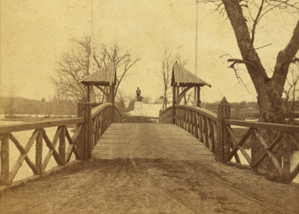
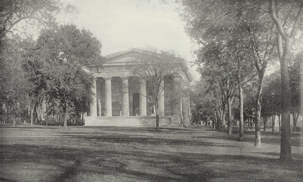
The Connecticut State House on the New Haven Green, seen from the south side of the building, sometime around the 1870s or 1880s. Image from The Connecticut Quarterly (1895).

The scene in 2018:

During the early colonial period, the modern-day state of Connecticut actually contained two separate colonies. In the northern part of the state was Connecticut Colony, which was centered around Hartford on the Connecticut River. To the south, along the shores of Long Island Sound, was New Haven Colony, which was centered around its namesake town. These two colonies were ultimately merged in 1664, but the divide between Hartford and New Haven persisted for many years. In 1701, the two towns were designated as co-capitals of the Connecticut Colony, and legislative sessions altered between them, with the May session being held in Hartford each year, and the October session here in New Haven.

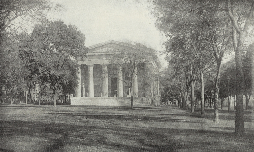
Two capital cities also meant two capitol buildings, and New Haven had a series of different state houses that were all located here on the New Haven Green. The last of these, which is seen in the first photo, was completed in 1831, replacing an earlier brick state house that had been in use since 1763. Its design was the work of Ithiel Town, a prominent Connecticut architect whose earlier New Haven works had included Trinity Church and Center Church, both of which are still standing nearby on the Green. Together, these three buildings demonstrated Town’s wide range of abilities, between the Federal-style Center Church, the Gothic-style Trinity Church, and the Greek Revival-style State House.

Town’s imposing design for the State House gave the building the exterior appearance of an Ancient Greek temple. It was built of stone, and had porticoes on both the north and south sides of the building, with classically-inspired columns, entablatures, and pediments. On the interior, the building included space for both the state and county governments. The basement and the first floor housed county offices, along with the county courtroom, a jury room, and various committee rooms. The upper floor had the two legislative chambers, with the House of Representatives at one end of the building and the Senate at the other, and there was also a room for the secretary and two rooms for the governor.

Following its completion in 1831, New Haven’s State House served, along with the older Hartford State House, as one of the state’s seats of government for more than 40 years. However, by the 1860s it was clear that maintaining two separate capitol buildings was both expensive and redundant. Railroads had significantly shortened the travel time between the two cities, which are a mere 35 miles apart, and the practice of having two capital cities apparently had more to do with each city’s sense of prestige than with any major convenience. Both cities lobbied hard to become the sole capital, and even Meriden threw its hat into the ring as a sort of compromise candidate. In the end, though, the question was settled by the voters of Connecticut, who chose Hartford as the capital, perhaps in part because of that city’s promise to contribute land and $500,000 toward the construction of a new State House.

The final legislative session at the New Haven State House was held here in 1874, and the following year Hartford took over as the state’s only capital. The new State House was completed in 1878, and still stands in Hartford’s Bushnell Park. In the meantime, the old 1797 State House was used as Hartford City Hall for many years, and it has since been preserved as a museum. However, here in New Haven the public sentiment was strongly divided over the fate of the city’s former State House. Having been vacated by both the state government and the county courts, the building was in need of a new use, and many argued in favor of preserving it and converting it into a public library. Perhaps with this proposal in mind, city voters approved an 1887 referendum to spend $30,000 on repairs to the building. However, the city council overruled this decision, and determined to demolish the iconic structure instead.

Even in the 1880s, long before the modern historic preservation movement gained widespread appeal, this was a highly controversial decision, with many praising the building’s architecture and its symbolic significance to the city of New Haven. Among the outside voices calling for its preservation was the Boston Advertiser, which published an editorial to that effect in 1889. In it, the newspaper argued:

That old State House is a priceless memento of a glorious past. It is a perpetual reminder that New Haven was originally an independent colony, and that, for nearly two centuries and a half it shared with Hartford the honor of being a state capital. Within those walls were uttered words whose echoes reached the continent and beyond the sea. Its style of architecture suggests the classic learning which, from the beginning, has been more faithfully taught in that locality than anywhere else in the world. . . . To tear down that building would be to obliterate one of the chief milestones on the path of time.

Not everyone in New Haven saw the State House in such a light, though. Apparently still embittered at losing the capital contest to Hartford some 15 years earlier, the New Haven Register responded to the Advertiser with an editorial of its own, arguing:

It will be news to most New Haveners to be told that the State House is a “priceless memento of the glorious past.” It is not, nor has it ever been priceless. It is a memento of New Haven’s folly in allowing Hartford to gobble up the capital. It is a perpetual reminder that New Haven in the past has shown a deplorable lack of public spirit in important crises. It is not a “chief milestone on the path of time.” Rather it is an encumbrance, a public nuisance, a bone of contention, an eyesore, a laughing stock, a hideous pile of brick and mortar, a blot on the fair surface of the Green. The Boston paper doesn’t know what it is talking about.

Both of these excerpts are quoted from The New Haven State House, a book that was published in 1889 shortly after the building was demolished. Interspersed within this history of the building were a number of advertisements, several of which attempted to use the demolition as a marketing strategy. One such ad declared “Two Great Mistakes! The greatest mistake ever made by New Haven people is shown by the destruction of the State House. The Second Mistake is in supposing that B. Booth has only second hand and auction goods at 388, 390 and 392 State St.” Another simply stated “The State House Gone. The City Market Remains,” and a third was for a photographic studio that promised “the Best Views of the Old State House that were made.”

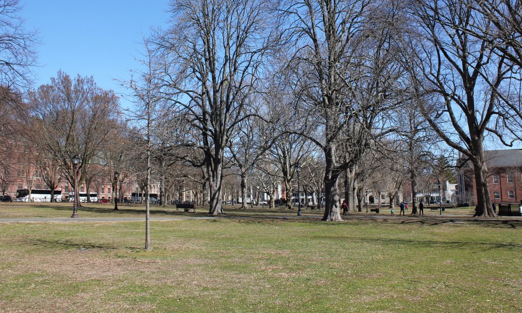
Following the demolition of the State House, the area was cleared and reverted to open park land, as part of the New Haven Green. However, this western portion of the Green, known as the Upper Green, was also the city’s colonial-era burial ground, where an estimated 4,000 to 5,000 people were buried. The headstones have long since been removed – aside from a small portion of the graveyard that is located in the basement of Center Church – but the remains themselves are still interred here under the Green. Today, though, there is little here to suggest the presence of a burial ground, or the former presence of a state capitol building. However, the New Haven Green is not without historic buildings, as three early 19th century churches still stand on the far right side of this scene, including the two designed by Ithiel Town.

Mark Twain House, Hartford, Connecticut

The Mark Twain House on Farmington Avenue in Hartford, around 1880. Image courtesy of the New York Public Library.

The house in 2018:

Samuel Clemens, better known by his pen name Mark Twain, was born and raised in Missouri, and he is probably best identified with the Mississippi River, where many of his works are set. However, Mark Twain actually spent much of his literary career in Hartford. He moved here in 1871, a year after his marriage to Olivia Langdon, and the couple initially rented a house here in the Nook Farm neighborhood. Mark Twain came to Hartford in part because it was the home of his publisher, Elisha Bliss. However, the city also enjoyed a thriving literary community, with prominent authors such as Charles Dudley Warner and Harriet Beecher Stowe also living in Nook Farm.

After several years of renting, Mark Twain decided to build a house of his own. He purchased a lot on Farmington Avenue, just around the corner from Harriet Beecher Stowe’s house on Forest Street, and he hired architect Edward Tuckerman Potter, who designed this ornate High Victorian Gothic-style house. It was completed in 1874, and the family would go on to live here for the next 17 years. At the time, the couple had two young daughters, Susy and Clara, and a third daughter, Jean, would be born in 1880. They had one other child, a son named Langdon, but he died in 1872 at the age of 19 months. The first photo was taken around the time that Jean was born, and it shows the house as it appeared before the servants’ wing was added to the right side of the scene in 1881.

Mark Twain was already a prominent author by the time he moved into this house, having recently published books such as The Innocents Abroad (1869) and The Gilded Age: A Tale of Today (1873). However, his 17 years at this house would become perhaps the most productive of his career, and he wrote many of his most famous works here, including The Adventures of Tom Sawyer (1876), A Tramp Abroad (1880), Life on the Mississippi (1883), The Prince and the Pauper (1881), Adventures of Huckleberry Finn (1884), and A Connecticut Yankee in King Arthur’s Court (1889).

Despite significant literary success throughout the 1880s, Mark Twain suffered several major financial setbacks in the early 1890s. Because his Hartford house was so expensive to maintain, he and his family moved to Europe, where he went on lecture tours. He eventually succeeded in paying off his creditors and becoming financially stable again, but during this time he also experienced struggles within his own family. In 1896, his youngest daughter Jean was diagnosed with epilepsy – which would ultimately lead to her early death in 1909 at the age of 29 – and only five months later, in August 1896, his 24-year-old daughter Susy died of spinal meningitis. Her death hit the family particularly hard, and they never lived in this house again, in part because of its association with Susy.

Mark Twain finally sold this house in 1903, a year before his wife Olivia’s death. He would eventually return to Connecticut, although not to Hartford. In 1908, he built a home in Redding, near the southwest corner of the state in Fairfield County. He named it Stormfield, after his short story “Captain Stormfield’s Visit to Heaven,” which would prove to be his last story published during his lifetime. It was at Stormfield that, on Christmas Eve in 1909, Jean drowned after apparently having a seizure in the bathtub. Less than four months later, Mark Twain also died at his Redding house, having outlived his wife and three of his four children.

In the meantime, the new owner of his Hartford home was Richard M. Bissell, an insurance executive who would later go on to serve as president of The Hartford for many years. He and his wife Mary had three children who grew up here, including Richard M. Bissell, Jr., who was born in 1909. The younger Richard went on to become a high-ranking CIA executive during the Cold War. He was involved in the development of the U-2 spy plane, and he was later appointed Deputy Director for Plans in 1959, a position that put him in charge of planning clandestine operations. These included the disastrous 1961 Bay of Pigs Invasion, the failure of which ultimately led to his departure from the CIA in 1962.

Richard Bissell, Jr. spent the first eight years of his life here in this house, before he and his family moved to Farmington in 1917. The elder Bissell subsequently leased the house to the Kingswood School, a private school for boys that Richard Bissell, Jr. attended. The Bissell family sold the property in 1920, but the sale included a stipulation that allowed Kingswood to remain here until 1922. They did so, and after they left the new owners announced plans to demolish the house and build an apartment building on the site. These plans were eventually scrapped after a significant public outcry, and the interior of the house was instead divided into 11 apartment units in 1923.

The threatened demolition of the historic house helped to spur support for its preservation, and in 1929 it was purchased by the Mark Twain Memorial and Library Commission. The ultimate goal of this organization was to restore the house to its original appearance, but these plans took many years to come to fruition. In the meantime, the first floor became a branch of the Hartford Public Library, and the upper floors continued to be rented to residential tenants while the organization raised funds for the restoration.

This work was finally completed in 1974, and today the entire house is open to the public as a museum. Thanks to the preservation efforts that began nearly a century ago, there is very little difference between these two photos, aside from the addition of the 1881 servants’ wing. The neighboring Harriet Beecher Stowe House has also become a museum, known as the Harriet Beecher Stowe Center, and both of these houses are now designated as National Historic Landmarks because of their literary significance.

Pelham Street, Newport, Rhode Island

Looking east on Pelham Street, toward the corner of Spring Street in Newport, around the early 1880s. Image courtesy of the Providence Public Library.

The scene in 2017:

These photos show the same scene as those in an earlier post, just from the opposite view along Pelham Street. Here, a mix of 18th and 19th century homes line either side of the narrow street, with the United Congregational Church standing in the distance at the corner of Spring Street. Probably the oldest of these is the Langley-King House, which is partially visible on the extreme left of the photo. It was built around 1710, expanded around the mid-18th century, and eventually restored in the early 1970s. Next to it is the three-story John Gidley House, which was built around 1744, and further in the distance are several other homes that date to around the 18th century.

On the right side of the street, probably the newest house in the first photo is the Anthony Stewart, Jr. House. It was built around the 1860s or early 1870s, and its Victorian-era Mansard roof and bay windows stand in sharp contrast to the colonial-era buildings all around it. Its neighbor to the right, the c.1804 Jonathan Bowen House, also features a Mansard roof, although this was evidently added at some point after the first photo was taken. Further in the distance on the right is the small gambrel-roofed Lucina Langley House, which was built sometime before 1771 and still stands at 43 Pelham Street. However, its neighbor to the left, at the corner of Spring Street, was demolished sometime soon after the first photo was taken, and was replaced by the present-day William M. Austin House in 1883.

Perhaps the most historically significant building in this scene is the United Congregational Church. This Romanesque Revival-style brownstone church was completed in 1857, and was the work of noted New York architect Joseph C. Wells. At the time, the interior was largely plain, in keeping with the Puritan traditions of the Congregational Church, but this changed in 1880, when the prominent artist John La Farge was commissioned to redesign the interior. His only restriction was that he could not include illustrations of figures, or any Christian symbols, as these could be seen as violations of the second commandment’s prohibition of graven images. As a result, La Farge drew heavily upon Byzantine and even Islamic tradition, incorporating intricate geometric patterns and other abstract designs into his work. This ultimately included 20 stained glass windows, along with a number of murals on the walls and ceiling, and it was completed shortly before the first photo was taken.

Today, more than 130 years after the first photo was taken, remarkably little has changed in this scene. All of the houses are still here, except for the one on the right at the corner of Spring Street, and the church is also still standing. It is now partially hidden by trees and by the Austin House, but the only significant change is the loss of the pyramidal roofs atop the towers, which were destroyed in the 1938 hurricane and were never replaced. All of the buildings in this scene are now part of the Newport Historic District, a National Historic Landmark district that was created in 1968. However, the United Congregational Church was also individually designated as a National Historic Landmark in 2012, in recognition of La Farge’s interior design of the building.

Spring Street from Prospect Hill Street, Newport, Rhode Island

Looking north on Spring Street from the corner of Prospect Hill Street in Newport, around 1888. Image courtesy of the Providence Public Library.

The scene in 2017:

Downtown Newport has a remarkable collection of historic buildings from the 18th and early 19th centuries, but few street scenes have remained as well-preserved as this block of Spring Street. Aside from the addition of pavement and telephone poles, there are hardly any differences between these two photos, which were taken nearly 130 years apart. However, these buildings were already old when the first photo was taken, so it has been nearly 250 years since there were any major changes to this scene.

Most of the buildings in this scene date back to the mid to late 18th century. Starting in the foreground, at the corner of Spring Street and Prospect Hill Street, is the Lyn Martin House, which was built sometime between 1758 and 1777. The next two houses were also built during this same time period, including the Robert Brattle House at 209 Spring Street, and the Benjamin Howland House further in the distance at 205 Spring Street. Just beyond the Howland House is the Cremin House at 199 Spring Street, which was somewhat newer than its neighbors, having been built around 1785-1790. However, the newest building along this section of Spring Street is the William N. Austin House, which is barely visible on the far right side of the scene. It was built in 1883 at the corner of Spring and Pelham Streets, and replaced a very modest colonial-era building that once stood on the site.

With the exception of the Austin House, all of these buildings date back to Newport’s golden age as a prosperous seaport in the 18th century. However, the American Revolution caused irrevocable harm to Newport’s shipping industry, and the city experienced a long economic decline throughout the first half of the 19th century. As a result, though, there was very little new development in the city during this period, which may have helped contribute to the survival of so many colonial-era buildings, including these ones along Spring Street.

By the time the first photo was taken around 1888, Newport has reinvented itself as one of the nation’s premier resort communities, with the Vanderbilts, Astors, and other Gilded Age families spending their summers in palatial seaside homes. Most of this development was occurring in the southern part of Newport, leaving the downtown area largely intact as a quaint reminder of the city’s past. There are a few signs of progress, including the trolley tracks on Spring Street, but otherwise the scene looks much the same as it would have been a century earlier.

Today, all of the buildings from the first photo are still standing, with only a few significant alterations. The most obvious of these is the addition of the porch on the left side of the Martin House, but other changes include the dormer windows atop the neighboring Brattle House. Further in the distance, there are no noticeable changes to the Howland House, but it is now operated as the Howland House Inn. Along with much of the surrounding area, these buildings are now part of the Newport Historic District, which was designated as a National Historic Landmark in 1968.

Spring Street from Church Street, Newport, Rhode Island

Looking north on Spring Street from the corner of Church Street in Newport, around 1887. Image courtesy of the Providence Public Library.

The scene in 2017:

These photos were taken directly across Spring Street from Trinity Church, and show the west side of the street, on the block between Church and Mary Streets. A small portion of the churchyard is visible on the far left side of the scene, with an assortment of commercial and residential buildings beyond it. Most of the buildings from the first photo are still standing today, with remarkably few exterior changes, but the one significant difference between the two photos is the building in the foreground, at the corner of Church Street. The first photo shows a colonial-era, gambrel-roofed house that was probably built in the early or mid-18th century. It was probably constructed as a house, but by the late 19th century it included a storefront on the Spring Street facade, which was occupied by the L. Schaefer shoe repair shop. However, the building was demolished sometime around the turn of the 20th century, when the present-day building was constructed on the site.

Further down the street, most of the buildings are still standing. Starting closest to the foreground is the blue and white John Preston Mann House, which was built around 1827. Next to it, with the mansard roof and two-story bay window, is the William B. Sherman House, which was built around the 1860s and is now the Outlook Inn. Further in the distance, barely visible in both photos, is the gambrel-roofed Samuel Barker House. This elegant house was built around 1714, and stands as probably the oldest recognizable building in this scene, predating most of its neighbors by more than a century. Today, all of these buildings, including the turn-of-the-century corner building, are now contributing properties in the Newport Historic District, which was designated as a National Historic Landmark in 1968.

Broadway from Farewell Street, Newport, Rhode Island

Looking north on Broadway from the corner of Farewell Street in Newport, around 1884. Image courtesy of the Providence Public Library.

The scene in 2017:

This view shows the west side of Broadway, looking north from the Colony House at the corner of Farewell Street and Courthouse Way. Although taken more than 130 years apart, not much has changed in these two photos. Like much of downtown Newport, this area has remained remarkably well-preserved since the colonial era, and both photos show an eclectic mix of historic buildings that date as far back as the 17th century.

Perhaps the oldest building in this scene is the one on the far left, at 2-6 Broadway. It was built sometime before 1700, and was once owned by Peleg Sanford (1639-1701), who served as the colonial governor of Rhode Island from 1680 to 1683. Sanford came from a leading Rhode Island family, with his father, John Sanford (c.1605-1653), having briefly served as governor of Newport and Portsmouth in 1653. However, his most notable relative was his grandmother, Anne Hutchinson (1591-1643), the famed religious dissenter whose 1638 banishment from Boston had helped lead to the establishment of Newport.

Peleg Sanford died in 1701, and the house was later owned by his son-in-law, Job Almy, who purchased the property in 1723. The house would remain in the Almy family for over a century, until it was sold in 1827. By this point, the first floor of the house had been converted into a storefront, and the building would see even more drastic changes around 1845, when it was enlarged to its present size. This addition concealed most of its original appearance, although the building retained its overhanging second floor, which was a distinctive feature of many 17th century homes.

By the time time the first photo was taken around 1884, the building was occupied by several commercial tenants, including J. B. Deblois & Son, whose grocery store was located in the corner storefront. In later years, the ground floor was occupied by Lalli’s, a variety store that was in business here from 1923 until 1986. It was during this time that, in 1976, the exterior of the building was restored, giving it more of a 17th century appearance. Today, despite all of these changes, the structure of the original house is still there, making it possibly one of the oldest surviving buildings in Newport.

Aside from the Peleg Sanford House, there are a number of other historic buildings in this scene. Immediately to the right of it is the William P. Shefield House, which was built around 1850, although its exterior has been altered beyond recognition since the first photo was taken. Next, in the center of the scene, is the William H. Stanhope House, at 12-18 Broadway. It was built around 1815 as a private home, and its Federal-style architecture is still recognizable today, despite having been converted to commercial use during the 19th century. Further in the distance, barely visible in the 2017 photo, are two late 18th century homes at 20-24 and 26-30 1/2 Broadway, both of which are also now commercial properties.

Today, the vehicles on the street have changed, and this block of Broadway is now a one way street for southbound traffic, but otherwise the buildings themselves have seen few changes. All of them are now contributing properties in the Newport Historic District, which encompasses much of downtown Newport. The district was designated as a National Historic Landmark in 1968, because of the survival of so many historic buildings from the 17th, 18th, and 19th centuries.