Brooklyn Bridge Promenade

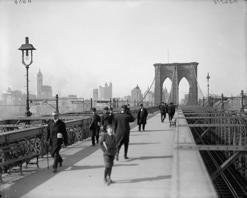
The view along the Brooklyn Bridge Promenade, looking toward Manhattan, between 1908 and 1920. Image courtesy of the Library of Congress, Detroit Publishing Company Collection.

125_1908-1920 loc

The same view in 2013:

125_2013

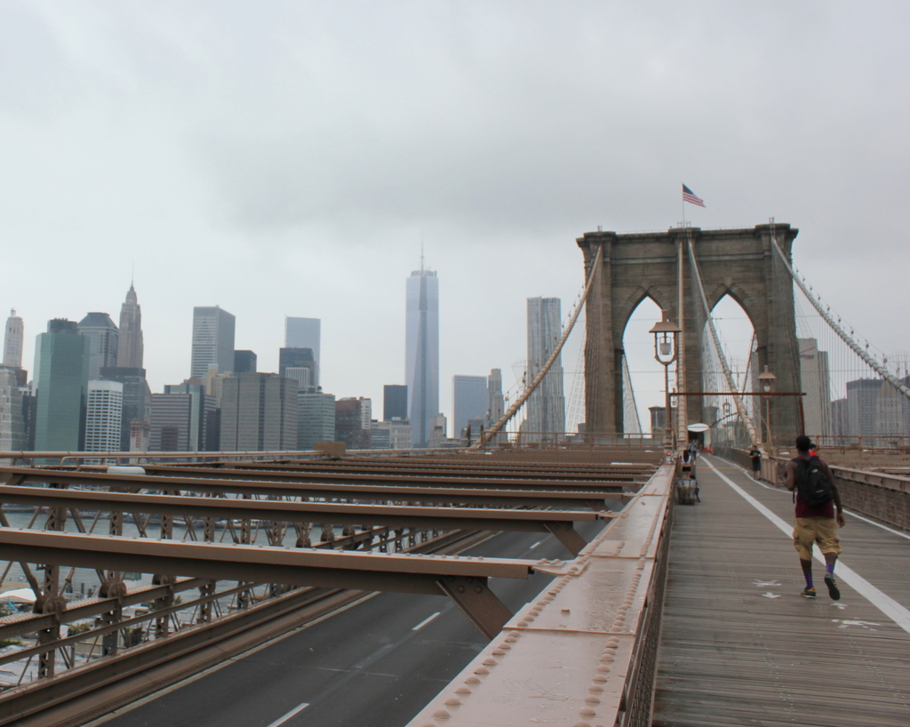
The angle here isn’t exact, since they were taken from different sides of the walkway, but both photos show the same view of the Brooklyn Bridge and of the Manhattan skyline.  The first photo is interesting, because although the subject of the photo is the bridge, the background shows three different buildings that were, at one point, the tallest in the world:

1. New York World Building: The tallest from 1890 to 1894, demolished in 1955 to expand the approaches for the Brooklyn Bridge.  The dome of the building is barely visible under the left-hand arch of the bridge tower.

2. Park Row Building:  Held the record from 1899 to 1901, and the building still exists, although it’s not visible in the 2013 photo.  It can be seen in the first photo, near the center, with the two towers on top.

3. Singer Building: Held the record from 1908 to 1909, and was demolished in 1968.  It is readily visible on the far left of the first photo, and its location today is marked by One Liberty Plaza, the large black rectangle at the base of the new World Trade Center building.

Corner of Dwight and Sanford Streets, Springfield

The building that once stood at the corner of Dwight and Sanford Streets. Photo from Springfield Present and Prospective (1905).

120_1800s spp

The location in 2014:

120_2014

As seen in today’s photo, the buildings in the first photo don’t exist anymore, and in fact neither does the street on the right, Sanford Street. The first photo shows two different 17th century houses: the old Nathaniel Ely Tavern in the foreground, built in 1660, and the Margaret Bliss House just beyond it, built around 1695. Obviously both buildings are long gone. I don’t know when they were demolished, but it is safe to say they were gone before the MassMutual Center was built in the 1970’s.

Monson Academy, Monson, Mass.

The old Monson Academy building, prior to the 1880s. Photo from Our County and Its People: A History of Hampden County, Massachusetts (1902).

118_1860s-1880s ocaip

The second Monson Academy building, probably around 1900. Photo from Our County and Its People: A History of Hampden County, Massachusetts (1902).

118_1900c ocaip

The same site in 2010:

118_2010

And one year later, following the June 1, 2011 tornado:

118_2011

Monson Academy was founded in 1804, when the building in the first photo was built. It served as the main building until 1886, when it was destroyed in a fire. It was replaced by the building in the second photo, which also burned, in 1953. Finally, in 1961, the building in the last two photos, Harper Gumnasium, was built on the site. Barely visible to the right of the Harper Gymnasium is the much-older Holmes Gymnasium, which was built in 1900. Both buildings were destroyed by the June 1, 2011 tornado, and were demolished the following year.

Holmes Gymnasium, Monson, Mass.

The Holmes Gymnasium, part of Monson Academy, taken between 1900 and 1902. Photo from Our County and Its People: A History of Hampden County, Massachusetts (1902).

117_1900-02 ocaip

The building in 2006:

117_2006

The building in 2011, in the immediate aftermath of the June 1 tornado:

117_2011

Holmes Gymnasium was built as part of Monson Academy in 1900, on the hill overlooking downtown Monson.  Although the academy moved to Wilbraham in 1971 to merge with Wilbraham Academy, the building survived until 2011, when it had its entire upper floor sheared off by the June 1 tornado that devastated West Springfied, Springfield, Monson, Brimfield, and other Western Mass towns. The remains of the building were demolished the following year.

Old City Hall, Springfield, Mass

Springfield’s old City Hall, sometime before 1905. Photo from Springfield Present and Prospective (1905).

115_1905c spp

The view in 2023:


Although settled in 1636, Springfield wasn’t incorporated as a city until 1852. Four years later, the first city hall was built here, on the north side of Court Square. It was dedicated with much fanfare on January 1, 1856, and stood here for nearly 50 years. During this time, the city offices were housed on the first floor, with the police department in the basement and a 2,300-seat auditorium on the upper floor. The auditorium was used for a variety of events, including one that resulted in the destruction of the building. On January 6, 1905, a fire started in the auditorium, allegedly caused when a monkey overturned a kerosene lantern. Regardless of the cause, though, the building was a total loss, and eight years later the present-day Springfield Municipal Group was dedicated, with new City Hall, Symphony Hall, and campanile tower in between. Today, the only remnant of the old building is its bell, which is located on the corner just to the right of the current City Hall.


Court Square Theater, Springfield

Springfield’s Court Square Theater, as it appeared between 1900 and 1910. Image courtesy of the Library of Congress, Detroit Publishing Company Collection.

112_1900-1910-2Bloc

The building in 2015:


The Court Square Theater was built in 1892, and substantially expanded in 1900.  Originally, the building was symmetrical, but the 1900 addition gave the building an extra five rows of windows on the front facade, and also extended the right-hand side of the building all the way back to State Street.  A photo on this blog shows a rare glimpse of the building prior to the expansion.  The other two buildings visible along Court Square are the the 1835 Byers Block, and the 1889 Chicopee Bank Building.  Neither buildings have changed much in appearance since the first photo was taken.

Right now, the Court Square Theater building stands vacant.  The theater section itself (not visible) was demolished in 1957, and there have been various proposals for restoring the building, but so far none have begun.