Boylston Street, Boston

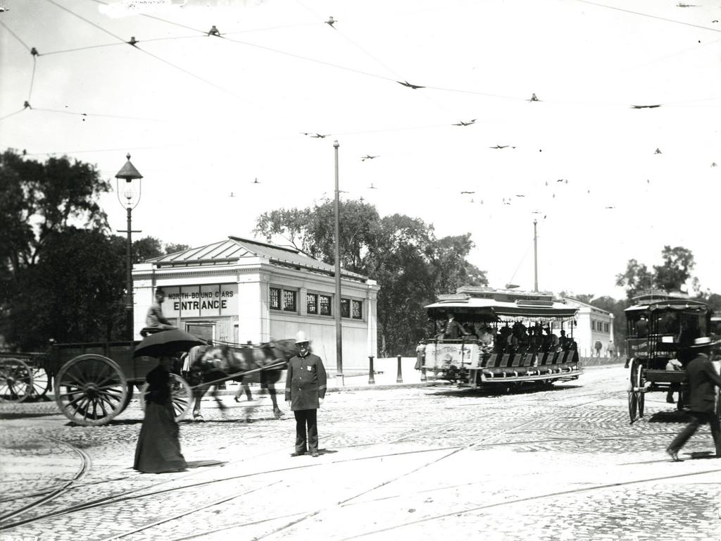
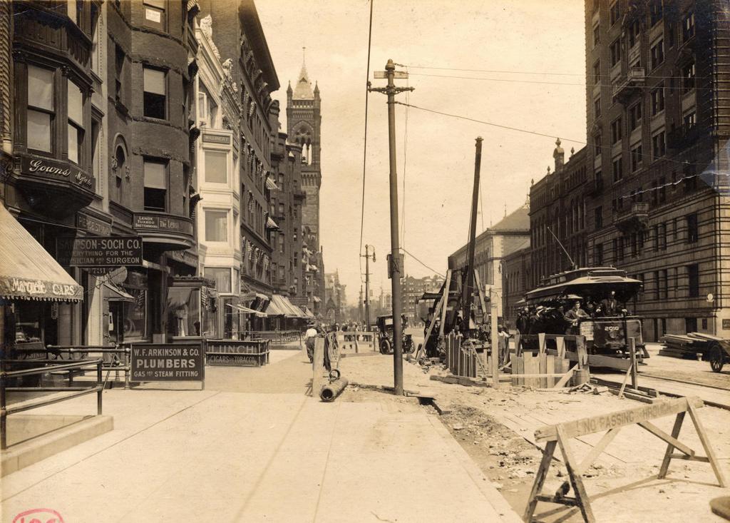
The view looking east on Boylston Street from just west of Exeter Street, on July 19, 1912. Image courtesy of the City of Boston Archives.

696_1912-07-19 coba

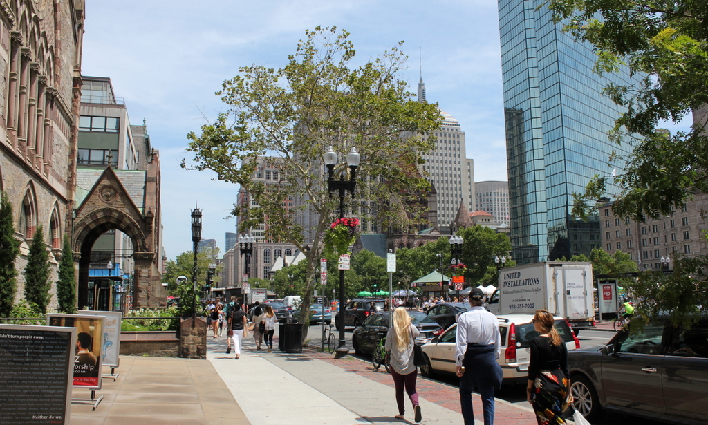
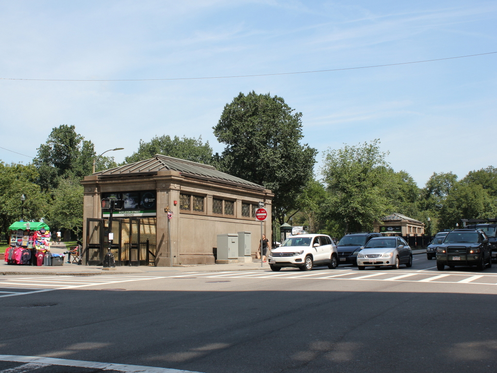
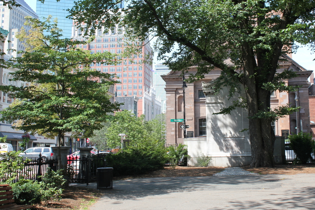
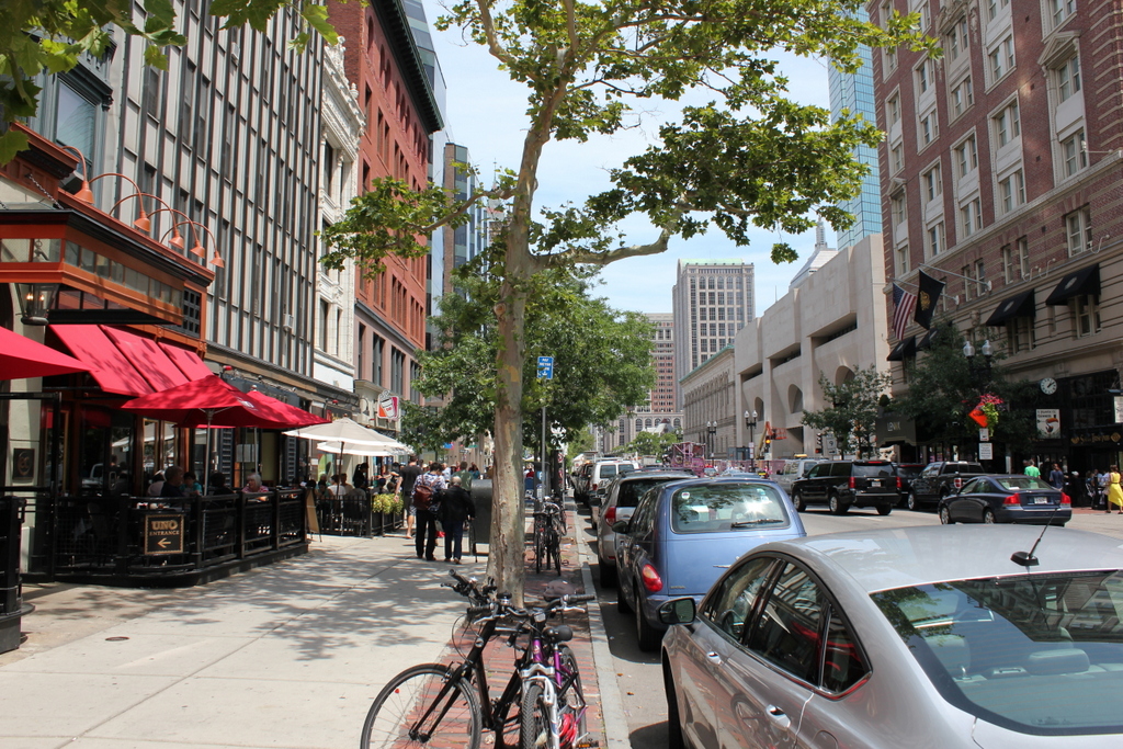
Boylston Street in 2015:

696_2015
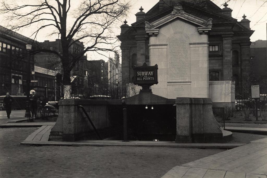
These photos were taken a little over a block away from where the the photos in the previous post were taken, and they show Boylston Street in the area just west of Copley Square.  The first photo was taken during construction of the Boylston Street Subway, which was completed in 1914 and allowed trolleys, such as the one seen in the photo, to travel under Boylston Street along the present-day Green Line.

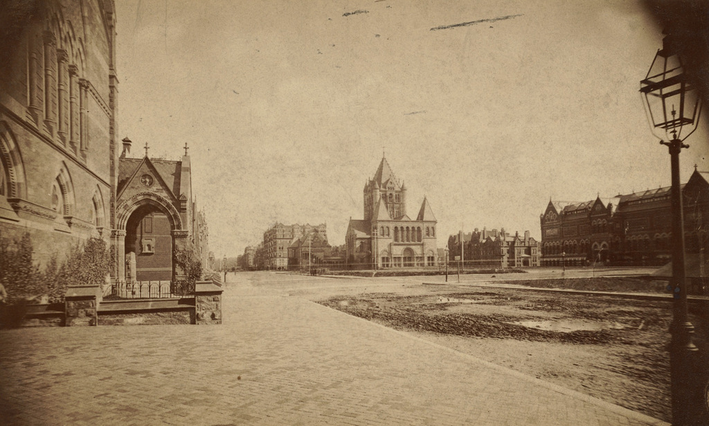
Most of the older brownstone buildings seen on Boylston Street in the first photo have since been demolished, but many of the newer commercial buildings are still standing today.  These include, on the left side of the street, the small white building, which was built around 1908, and the larger red brick building beyond it.  In the distance is the tower of the New Old South Church, which was rebuilt in 1940 and today is partially hidden in this view.

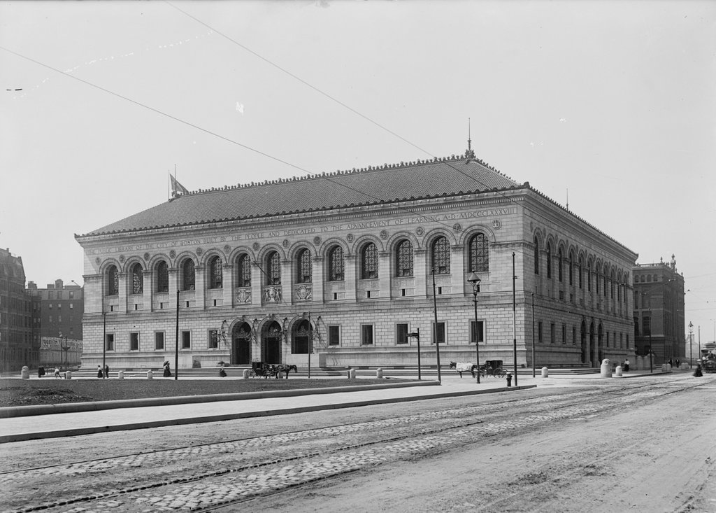
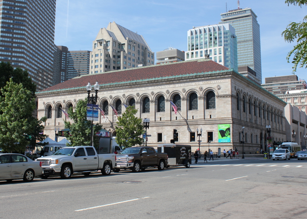
On the right-hand side of the street, the McKim Building of the Boston Public Library can be seen in the distance; it was completed in 1895, and is still the main branch of the Boston Public Library today.  However, the library has long since outgrown the original building, so today the circulating collections are housed in the much more modern-looking Johnson Building, which was completed in 1972 and can be seen in the right center of the photo.  On the far right of both photos is the Hotel Lenox, which was built around 1901 and is still a hotel today, with few changes to the building’s exterior appearance.

One item of interest from the first photo is the trolley to the right.  It is overflowing with passengers, some of whom appear to be hanging on to the outside of the car.  There is a poster on the front of the car that reads “Baseball To-day, American League,” so these passengers were probably heading to Fenway Park, which had opened just a few months earlier.  On this particular day, the Red Sox were playing a doubleheader against the White Sox; Boston would end up winning both games, and later in the season they defeated the New York Giants in the World Series to win the team’s second championship title.  Over a century later, many Red Sox fans still take this route to Fenway Park, although today the trolleys run under the street in the tunnel that was being built in the first photo.

Copley Square, Boston (2)

Copley Square as seen from in front of the New Old South Church in Boston, in 1893. Image courtesy of the Boston Public Library.

695_1893 bpl

Copley Square in 2015:

695_2015
The first photo shows Copley Square as it appeared only about 20 years after this section of Boston was developed.  In the second half of the 19th century, the Back Bay was transformed from a polluted marsh to one of the city’s premier neighborhoods.  Many of the city’s important cultural institutions moved here, with many of them surrounding the Copley Square area, including the New Old South Church on the left, the Trinity Church in the center, and the Museum of Fine Arts on the right.  Also under construction, but just out of view of the camera on the right, was the main branch of the Boston Public Library.

Today, the Copley Square area has seen some significant changes from the 19th century.  It remains the focal point of the Back Bay, but what started as neighborhoods of Victorian rowhouses evolved into low-rise commercial buildings, and eventually modern skyscrapers, especially in the area south of Boylston Street.  The two churches from the 1893 photo are still standing, but all of the other buildings are gone, including the Museum of Fine Arts, which moved to a larger facility further down Huntington Avenue in the early 1900s.  The old building was demolished, and replaced in 1912 with the Copley Plaza Hotel, which still stands today.

The most prominent new building in the 2015 scene is the John Hancock Tower, which was completed in 1976 and is the tallest building in New England.  Beyond it, near the center of the photo, is the 1947 Berkeley Building, which is also known as the Old John Hancock Building.  Together, these skyscrapers, along with the ones seen facing the other direction in this post, make up Boston’s High Spine, a string of skyscrapers extending west from downtown Boston, roughly along the Boylston Street and the Massachusetts Turnpike.

Boylston Station, Boston

The Boylston subway station, at the corner of Tremont and Boylston Streets in Boston, on August 12, 1897. Image courtesy of the City of Boston Archives.

687_1897-08-12 coba

The station in 2015:

687_2015
The first photo captures the ending of one era and the beginning of another.  Just a few weeks after the photo was taken, the trolleys that are seen here on congested Tremont Street would be moved underground, giving Boston the distinction of having the country’s first subway tunnel.  The first two stations were Park Street, just over a quarter mile to the north, and this one here at Boylston Street, in the southeast corner of Boston Common.  The project was a major civil engineering milestone, but it didn’t come without tragedy.  At this location earlier in the year, a leaking gas line in the work area under the intersection caused an explosion that killed six people.  The explosion is explained further in this post, which features photos that were taken diagonally across the street from here.

Today, the view really hasn’t changed too much.  The trolleys on the Green Line are still running under this intersection, the distinctive station entrances are still here, as is Boston Common in the background.  Even in the 19th century, this intersection of Boylston and Tremont streets was busy, necessitating the police officer in the left center of the 1897 photo.  The slow shutter speed of the camera has blurred most of the traffic around him, but he is standing perfectly still, posing for the photographer as trolleys, carriages, and pedestrians pass by.  It is still a major intersection today, albeit without the nostalgia of a 19th century officer directing traffic on a cobblestone street.

Arlington Station, Boston

The entrance to the Arlington subway station, taken from the Boston Public Garden in front of the Arlington Street Church, on March 17, 1937. Image courtesy of the City of Boston Archives.

680_1937-03-17

The scene in 2015:

680_2015
When the present-day Green Line subway tunnel was built in 1897, it only went as far west as Arlington Street; from here, the trolleys came to the surface (as seen in this post) and traveled along the center of Boylston Street through the Back Bay.  However, in 1914 the subway was extended west to Kenmore Square, and from here the closest stations were either a third of a mile to the east at Boylston, or an equal distance to the west at Copley Square.  This gap was resolved in 1921 when Arlington station opened here, with the original entrance being located in the Public Garden at the corner of Arlington and Boylston Streets.

The station has been renovated over the years, and the Public Garden entrance no longer exists, but many of the surrounding buildings from nearly 80 years ago are still standing.  The most prominent is the 1861 Arlington Street Church, which is partially blocked in both photos by the back of a statue and monument honoring William Ellery Channing, a Unitarian minister who was once the pastor of the congregation that later built the church.  Many of the buildings along Boylston Street in the distance are also still there today, but the skyline behind them has dramatically increased; some of the skyscrapers visible today include the old John Hancock Building, the new John Hancock Tower, and the Prudential Tower.

Hotel Bristol, Boston

The Hotel Bristol on Boylston Street, just west of Clarendon Street, on October 4, 1912. Image courtesy of the City of Boston Archives.

677_1912-10-04 coba

The scene in 2015:

677_2015
The Hotel Bristol was built at the corner of Boylston and Clarendon Streets sometime in the 1870s, probably soon after the land was filled in as part of the massive Back Bay landfill project.  I couldn’t find too much information on the hotel, and it does not appear to have been one of the city’s top hotels.  It was probably more of a residential hotel, catering to long-term occupants as opposed to temporary visitors.  In the 1912 photo, there were also several businesses on the ground floor, including an auto supply company on the left and a drugstore, T. Metcalf Co., to the right.  Barely visible on the extreme right is the Walker Memorial Building, part of the original Massachusetts Institute of Technology campus before the school moved across the river to Cambridge.  That building was demolished in 1939, but I don’t know how long the Hotel Bristol survived.  It was still listed on the 1938 city atlas, but today the site is occupied by a modern office building.

Boston Public Library, Boston

The Boston Public Library’s McKim Building at Copley Square in 1899. Image courtesy of the Library of Congress, Detroit Publishing Company Collection.

674_1899c loc

The building in 2015:

674_2015
This style of Renaissance Revival architecture was common for public libraries in the United States in the early 20th century, but Charles Follen McKim’s design for the Boston Public Library was the first.  It was constructed between 1888 and 1895, and is one of the most architecturally significant library buildings in the country.  It set the stage for similar grand libraries in American cities, including the main branch of the New York Public Library, which opened just over a decade later. Like many of Boston’s other cultural institutions, the library was strategically located in the Back Bay neighborhood, which had gone from polluted tidal marsh to affluent residential neighborhood in less than 50 years. However, one of the challenges in constructing large buildings here was the high water table and the tendency of the filled-in ground to subside.  As a result, the 19th century Back Bay buildings are supported by wooden piles; the library alone has about 4,000  piles that were driven 25 to 31 feet into the ground in the 1880s.

Today, the McKim Building is well-preserved on both the exterior and interior.  The interior includes a grand staircase and the massive Bates Hall reading room, along with a central courtyard, all of which was, as the inscription reads, “dedicated to the advancement of learning.” The main branch of the Boston Public Library has since outgrown the original building, so in 1972 an addition was put on the back, expanding the building to include the entire city block between Dartmouth and Exeter Streets.  Named after its architect, Philip Johnson, this building houses the library’s circulating collections, leaving the original building for the library’s extensive research collections.  Many of these collections are also available online, including a large number of historic photographs on Digital Commonwealth, which has been a great resource for this blog.

The greatest change in this scene, however, is the city around the library.  The section of the Back Bay to the north of Boylston Street has been largely preserved in its original Victorian appearance.  However, to the south of Boylston Street, as seen here, the area has become home to some of the city’s tallest buildings, including the Prudential Tower to the right, the second-tallest in New England after the nearby John Hancock Tower.  Probably the oldest building in the 2015 photo other than the library is the Lenox Hotel, barely visible on the far right beyond the library.  It was built in 1900, so it may have even been under construction when the first photo was taken.